- Time of past OR future Camino
- 2016 SJPP-Logrono
2022 Leon-Sarria
2023 Frances
-
Remove ads on the forum by becoming a donating member. More here.
Search 74,075 Camino Questions
You are using an out of date browser. It may not display this or other websites correctly.
You should upgrade or use an alternative browser.
You should upgrade or use an alternative browser.
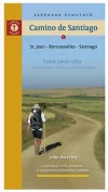
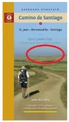
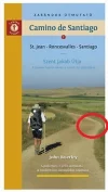
John Brierley cover photo
- Thread starter Cathy G
- Start date
The one from Galicia (the round) and the one from Castilla & Leon. Individually numbered and made by the same people that make the ones you see on your walk.
- Time of past OR future Camino
- cycled from Pamplona Sep 2015;Frances, walked from St Jean May/June 2017. Plans to walk Porto 2020
I was originally of the opinion that is was somewhere between Santo Domingo de Calzada and Belorado; but the meseta might be a better choice possibly half way down the Alto de Mostelares looking (over Itero) towards the Tierra de Campos (around Boadilla). But happy for someone to come up with a more accurate location. (I had a good look through the book and there is nothing to identify any of the photographs other than those well known sights.) Cheers
- Time of past OR future Camino
- First one in 1977 by train. Many since then by foot. Next one ASAP.
Can someone tell me where exactly in the Meseta the cover photo on Brierley's book is taken?
Very glad you asked! I've wondered about that myself....
Last edited:
€2,-/day will present your project to thousands of visitors each day. All interested in the Camino de Santiago.
- Time of past OR future Camino
- Most recent: Fall 2023 Aragonés, Frances
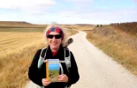
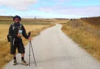
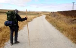
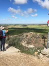
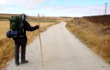
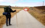
In September 2012, walking with my dear friends Helen, John and Simon (all pictured ), we think we identified the location between Ledigos and Moratinos. Helen had been keeping a look out for the spot and I'll never forget the shout from up ahead "I think I found it!". Interested to hear if others agree with us! I recently attended a Canadian Company of Pilgrims event and John Brierley was the guest speaker. I talked with him after and the cover location was a question I had meant to ask but forgot to!
Attachments
Last edited:
RJM
Veteran Member
- Time of past OR future Camino
- Camino's Frances, Fisterre, Portuges. Over 180 day
Hmmm...could be. Not sure.In September 2012, walking with my dear friends Helen, John and Simon (all pictured), we think we identified the location between Ledigos and Moratinos. Helen had been keeping a look out for the spot and I'll never forget the shout from up ahead "I think I found it!". Interested to hear if others agree with us! I recently attended a Canadian Company of Pilgrims event and John Brierley was the guest speaker. I talked with him after and the cover location was a question I had meant to ask but forgot to!
Comparison:
Ideal sleeping bag liner whether we want to add a thermal plus to our bag, or if we want to use it alone to sleep in shelters or hostels. Thanks to its mummy shape, it adapts perfectly to our body.
€46,-
€46,-
- Time of past OR future Camino
- Most recent: Fall 2023 Aragonés, Frances
Maybe compare the curves of the road. The pilgrim on the Brierley cover is standing closer to the curve than my pals in my photos. The landscape and the lines of the cultivated area above and to the right seem very close.
RJM
Veteran Member
- Time of past OR future Camino
- Camino's Frances, Fisterre, Portuges. Over 180 day
Maybe compare the curves of the road. The pilgrim on the Brierley cover is standing closer to the curve than my pals in my photos. The landscape and the lines of the cultivated area above and to the right seem very close.
The road curvature could be similar to so many places on the Camino.
I was thinking along the line of terrain features. Those two small distinct peaks on the ridgeline in the distance. That would be a unique terrain feature.
...and ship it to Santiago for storage. You pick it up once in Santiago. Service offered by Casa Ivar (we use DHL for transportation).
- Time of past OR future Camino
- Most recent: Fall 2023 Aragonés, Frances
My last bit of evidence in support of our location  On page 163 in the Brierley (2011 edition) there is a photo at the bottom of the page that shows the same location.
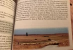
Upper right in this photo there are 3 features - A taller full tree, a skinny tree and a shorter bush. These show up on the Brierley cover as well. On the upper left of the page 163 photo there is very tall tree. All of these features are in this enlarged part of my photo.
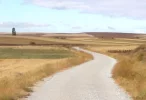

Upper right in this photo there are 3 features - A taller full tree, a skinny tree and a shorter bush. These show up on the Brierley cover as well. On the upper left of the page 163 photo there is very tall tree. All of these features are in this enlarged part of my photo.

- Time of past OR future Camino
- First one in 1977 by train. Many since then by foot. Next one ASAP.
Not bad, Theatregal !
I checked my 2012 edition, page 163 -- and my 2018 edition, too, where the 2012 picture appears on page 164.... I was skeptical of your suggestion at first, but the more I think about it the more plausible it seems! But that raises the question of WHERE between Ledigos and Moratinos?!
BTW - Brierley 2012 offered us just one ('gold dot') route between them, but Brierley 2018 offers an alternate ('green dot') Ledigos-Terradillos route. I assume that in 2012 you walked the 'gold dot' route?
RJM
Veteran Member
- Time of past OR future Camino
- Camino's Frances, Fisterre, Portuges. Over 180 day
Hmmm.....I believe you pilgrims were spot on. Good detective work.My last bit of evidence in support of our locationOn page 163 in the Brierley (2011 edition) there is a photo at the bottom of the page that shows the same location.
View attachment 54094
Upper right in this photo there are 3 features - A taller full tree, a skinny tree and a shorter bush. These show up on the Brierley cover as well. On the upper left of the page 163 photo there is very tall tree. All of these features are in this enlarged part of my photo.
View attachment 54095
The 2024 Camino guides will be coming out little by little. Here is a collection of the ones that are out so far.
- Time of past OR future Camino
- Most recent: Fall 2023 Aragonés, Frances
Looking at the timeline of my photos, it has to be between Terradillos and Moratinos - so somewhere in the 3km or so between. Yes, we walked the 'gold dot' route in 2012.Not bad, Theatregal !
I checked my 2012 edition, page 163 -- and my 2018 edition, too, where the 2012 picture appears on page 164.... I was skeptical of your suggestion at first, but the more I think about it the more plausible it seems! But that raises the question of WHERE between Ledigos and Moratinos?!
BTW - Brierley 2012 offered us just one ('gold dot') route between them, but Brierley 2018 offers an alternate ('green dot') Ledigos-Terradillos route. I assume that in 2012 you walked the 'gold dot' route?
- Time of past OR future Camino
- First one in 1977 by train. Many since then by foot. Next one ASAP.
I'll be walking that way in September -- and will let the Forum know what I see....
Get a spanish phone number with Airalo. eSim, so no physical SIM card. Easy to use app to add more funds if needed.
- Time of past OR future Camino
- cycled from Pamplona Sep 2015;Frances, walked from St Jean May/June 2017. Plans to walk Porto 2020
Wow - we sure do have some keen detectives on the forum. The more I look at the photo I agree that Ledigos to Sahagun is a possibility. If you know that most of these photos are taken in Spring or early Summer when the grain crops are high and green it helps with location. (John and his daughter do their walks in April and May, as I understand it). The reason I punted for the Itero area is that line of hills in the Western distance.. I have travelled this section in Sept and May and in May it was very green and wet. But hey unless John comes on line I doubt we will truly pin it down. Cheers
- Time of past OR future Camino
- .
After Castrojeriz you climb up to the Alto de Mostelares. As you look west it seems as if the flat plain goes on forever. But after a few kms it dips and you go downhill. This pic was taken shortly after reaching the bottom, still a few km from reaching the Ermita de San Nicolas.
- Time of past OR future Camino
- cycled from Pamplona Sep 2015;Frances, walked from St Jean May/June 2017. Plans to walk Porto 2020
Hola Tom, that was my thinking when I made my first post. I will search through my photos. I have one taken from the top, looking west. It might help.After Castrojeriz you climb up to the Alto de Mostelares. As you look west it seems as if the flat plain goes on forever. But after a few kms it dips and you go downhill. This pic was taken shortly after reaching the bottom, still a few km from reaching the Ermita de San Nicolas.
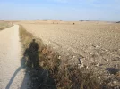
This the photo taken from the top of Castro; Alto de Mostelares. Cheers
Attachments
Last edited:
Train for your next Camino on California's Santa Catalina Island March 16-19
Mick Beede
New Member
- Time of past OR future Camino
- France's, Primitivo, Le Puy
I think you’re spot on TomAfter Castrojeriz you climb up to the Alto de Mostelares. As you look west it seems as if the flat plain goes on forever. But after a few kms it dips and you go downhill. This pic was taken shortly after reaching the bottom, still a few km from reaching the Ermita de San Nicolas.
RJM
Veteran Member
- Time of past OR future Camino
- Camino's Frances, Fisterre, Portuges. Over 180 day
Those trees match exactly to the ones in the guidebook as does their proximity to the ridge line and the ridge line itself. Pretty much nails it down.My last bit of evidence in support of our locationOn page 163 in the Brierley (2011 edition) there is a photo at the bottom of the page that shows the same location.
View attachment 54094
Upper right in this photo there are 3 features - A taller full tree, a skinny tree and a shorter bush. These show up on the Brierley cover as well. On the upper left of the page 163 photo there is very tall tree. All of these features are in this enlarged part of my photo.
View attachment 54095
- Time of past OR future Camino
- Us:Camino Frances, 2015 Me:Catalan/Aragonese, 2019
This looks like Brierley's cover also.
And checkout this thread: https://www.caminodesantiago.me/community/threads/a-photo-from-my-2014-camino.67425/
And checkout this thread: https://www.caminodesantiago.me/community/threads/a-photo-from-my-2014-camino.67425/
Ideal sleeping bag liner whether we want to add a thermal plus to our bag, or if we want to use it alone to sleep in shelters or hostels. Thanks to its mummy shape, it adapts perfectly to our body.
€46,-
€46,-
❓How to ask a question
How to post a new question on the Camino Forum.
Most read last week in this forum
Why in the world am I planning another camino? Isnt twice enough?
I was browsing german jakobswege and happened upon this list of (probably) current albergues on the market: https://www.jakobsweg.de/pilgerherberge-kaufen/.
In typical german fashion, all the...
Just curious.
I'm sure we ran a poll somewhere.
But I wonder in any given year, what the % of return Pilgrims might be?
A large proportion of us here seem to 'repeat offenders' but we are only a...
Has anyone walked the Camino while "shy" or introverted?
I (26 f, USA) am walking the Camino Frances in May 2025 mostly excited but also a bit nervous about the social aspect of the journey. I...
Im too tired to elaborate after walking 20KM and climbing 2 mountains today but this just happened:
The 'hospitalero' just made a joke at the bar towards me about what to do with my dead body if I...
- Locked
Similar threads
- Replies
- 13
- Views
- 2K
- Replies
- 20
- Views
- 2K
- Replies
- 14
- Views
- 804
❓How to ask a question
How to post a new question on the Camino Forum.
Most downloaded Resources
-
“All” Albergues on the Camino Frances in one pdf“All” Albergues on the Camino Frances in one pdf
- ivar
- Updated:
-
A selection of favorite albergues on the Camino FrancésFavorite Albergues along the Camino Frances
- Ton van Tilburg
- Updated:
-
Profile maps of all 34 stages of the Camino FrancesProfile maps of all 34 stages of the Camino Frances
- ivar
- Updated:


