Search 74,075 Camino Questions

Is the El Norte well signposted?

Gaelic59

El Norte aspirant
Time of past OR future Camino
Camino Frances 2011, 2013--now planning for Camino El Norte in May 2015
I am planning the El Norte for late May, and would like to hear
--the ease of finding ones way
--whether the road is predominantly trail or asphalt
--experiences and hints that could help
--references on books that I might benefit from.

I walked the Frances in 2011 & 2013 and found John Brierley's book very informative.
My Spanish is not good enough to follow the sites I have found.
Ayudarme por favor
eduardo
 
A selection of Camino Jewellery
Well marked, except when leaving Deba: a local land owner changes the arrows around so pilgrims will get lost. So in Deba, stop at the tourist info office and they will give you a handmade map with correct directions.

Mostly asphalt I'm afraid. And the few bits that aren't are steep, going up and down ;0) Do bring walking poles. If not super limber, avoid going over the Brusco as you come into to Noja, walk around. As beautiful as the views are, that is the one and only place I have ever felt was dangerous on my Caminos. Lovely ravine for you to fall backwards towards the surfers below.

Experience: the food and drinks! Aim for a mid-afternoon lunch and order Menu del dia. Gorgeous food most times, certainly much better than the CF Pilgrim menu. Plus, if you don't make that meal your main meal, you will find yourself eating sandwiches at night (bocadillos). Try the local Txacoli (sparkling wine), cidra (cider) and vermud solera (aged vermouth). For favourite meals: fabada (bean and meat soup) also called something or asturiano stew and has another name. Also grilled sardines. Anchovies in Santona. When in San Sebastian try two of the most well known restaurants for their pinxos (tapas): La cuchara de San Telmo and A fuego negro. Both on the same street in the old part of town, but La cuchara has its entrance on the back of the building, to the right of the little plaza. In Bilbao, in the old part of town, there is an inner courtyard with lots of pinxos restaurants all around it. Lots of wonderful food to sample. In llanes, indulge in Carbayones, a lovely local desert.

Tip, in Bilbao, do NOT stay at the albergue across the river from the Guggenheim, the Botxo. There is no security at night. Too bad because the location is fantastic. Impecable albergue, 50 meters from the train stop in Mogro where you should take the train to cross the brige: Casa piedad - duvet, bed made, towels, shampoo, private bathroom. In Noja, stay at the hotel la Casona - they have a few rooms for pilgrims at 10 euros. Mine had two single beds and its own bathroom with bathtub, and since noone else showed up I had it all for myself and for 10Euros. In on the main plaza, next to the church, restaurants and tourism info center and certainly beat the local muni on the way into town whom I've heard is falling apart. Also, do NOT stay at the albergue in San Vicente de la Barquera, but do go up the hill to the fortified part of the town and visit the church up there: it's one of these churches with such a special feel, and historical relevance, like Eunate on CF. In Santillana del mar stay in the pilgrim section of the Solar de Hidalgo, a magnificent manor house as you enter the older part of town, on your right. Pilgrim rooms in the back, but to get there you walk through 100s of years of history. Just skip the 4Euro breakfast. And in Santiallana have dinner at El pasaje de los nobles - little chabby chic place with a lovely menu. Has entrances on 2 streets. Finally, as you leave Guemes, aim for the longer route along the cliffs and not the inner route, along ... cars ;0)

As for guides, si hablas espanol Eduardo, why not go for la Guia practica del Camino de Santiago: Camino del Norte (Costa y primitivo) from Editorial Buen Camino. If German is up your alley, or if you just want very detailed maps of the area, and not just a sketch of the Camino path itself, why not try the Rother books.

Have a wonderful Camino!
 
If you buy the CSJ guides then you will have all the information you need including directions which is useful for those places where the signing is maybe less clear, there is a change of path or even a lorry blocking the view of the arrow :(. The 2 booklets Los Caminos del Norte A Ruta de la Costa; 1-Irun to Villaviciosa and 2-Villaviciosa to Melide will get you to the Francés where you will probably not need a guide book. CSJ have one but it covers the whole Francés, we did suggest having a Melide to Santiago section available but I don't think they do one yet.
 
3rd Edition. More content, training & pack guides avoid common mistakes, bed bugs etc
I am planning the El Norte for late May, and would like to hear
--the ease of finding ones way
--whether the road is predominantly trail or asphalt
--experiences and hints that could help
--references on books that I might benefit from.

I walked the Frances in 2011 & 2013 and found John Brierley's book very informative.
My Spanish is not good enough to follow the sites I have found.
Ayudarme por favor
eduardo
I waked the Norte/primitivo in June last year. Yes, the trails are well marked. As in CF, you have to be careful in/out of major towns.
W.r.t to asphalt, I find the Norte/primitivo and CF about the same. After so many ups/downs, asphalt is at times a relief for my feet. You can always walk along the grass edges if you are so anti-asphalt.
I relied entirely on the cicerone guide for everything, planning, maps, accommodation, contacts etc. Although it is not structured as good as Brierley's, it is the best English language guide.
An overview of the northern routes is also published by the tourism office.
Thanks for the update --that is useful first hand information.
 
I'm not sure how to put this less bluntly: El Camino del Norte (la costa) is being changed to benefit a bar and sidereria. The true camino leaves Gijón, rises up onto a ridge, runs along flat terrain for a bit, and then drops down to pass a church where peregrinos can rest, find fresh water, and even sleep overnight under some trees. The signs up on the ridge are being changed to direct peregrinos to drop down a kilometer before the church so that they pass by a bar/restaurant and sidereria. This puts peregrinos walking along a local 2 lane road instead of walking through trees, meadows, and not encountering cars. The camino has passed the church for over 1,000 years, but now due to political corruption the local council of municipality (el ayuntamineto de Carreño) is participating in this change without any public discussion… they are producing maps with the false camino represented as the true camino. It is very sad to watch this unfold.
 
A selection of Camino Jewellery
I'm not sure how to put this less bluntly: El Camino del Norte (la costa) is being changed to benefit a bar and sidereria. The true camino leaves Gijón, rises up onto a ridge, runs along flat terrain for a bit, and then drops down to pass a church (Santa Eulalia) where peregrinos can rest, find fresh water, and even sleep overnight under some trees. The signs up on the ridge are being changed to direct peregrinos to drop down a kilometer before the church so that they pass by a bar/restaurant and sidereria. This puts peregrinos walking along a local 2 lane road instead of walking through trees, meadows, and not encountering cars. The camino has passed the site of the church for over 1,000 years, but now due to political corruption the local council of municipality (Ayuntamineto de Carreño, Asturias) is participating in this change without any public discussion. The municipality is producing maps with the false camino represented as the true camino. It is very sad to watch this unfold.
 
Thanks for the information. Maybe a subversive local resident could occasionally repaint some of the yellow arrows to signal the original route? :)
 
Train for your next Camino on California's Santa Catalina Island March 16-19
Thanks for the information. Maybe a subversive local resident could occasionally repaint some of the yellow arrows to signal the original route? :)
True enough and already in the works. Obliterating the 12 false arrows for the false camino is first up.

The real camino is marked after the problem intersection.

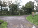
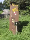
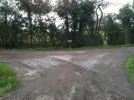
The problem intersection can been seen in the attached photos. The intersection where the false camino begins has signs for too many things and all too close together… and conflicting indications for the camino This will take some sorting out by someone in the local government who is not in on the change.

What I think would make a difference is one of those concrete posts with the camino's icon, the sea shell, planted awey from the others. Anybody know who makes and installs them?
 

Attachments

  • interseccion_a.webp
    interseccion_a.webp
    430 KB · Views: 15
  • interseccion_b.webp
    interseccion_b.webp
    752.4 KB · Views: 15
This is the original route, I take it?

View attachment 17306
Yes, that is the original route. One can find it on many web sites… the local issue is that the local government is placing metal signs of maps demonstrating false caminos. Check out the images above and you will see where the issue lies. To stay on the original route one has to take the road to the left that rises a bit… going to the right and down leads one to a local 2 lane road where cars and tractors drive
 
Last edited:
Thanks for the information. Maybe a subversive local resident could occasionally repaint some of the yellow arrows to signal the original route? :)
Hummmm… it appears that a subversive local resident took up your advice. The intersection that was causing the most confusion has been made clear by moving a sign and painting out erroneous arrows. Next up, communication with the local government so they learn where El Camino de Santiago runs and modify their various signs accordingly.
 

Attachments

  • intersection.webp
    intersection.webp
    149.7 KB · Views: 9
Train for your next Camino on California's Santa Catalina Island March 16-19

❓How to ask a question

How to post a new question on the Camino Forum.

Most read last week in this forum

Planning on walking Norte-Primitivo starting about June 10, 2025. Are the albergues very busy at that time and also what will the weather be? I did this the end of August and September of 2017 and...

Featured threads

❓How to ask a question

How to post a new question on the Camino Forum.

Featured threads

Forum Rules

Forum Rules

Camino Updates on YouTube

Camino Conversations

Most downloaded Resources

This site is run by Ivar at

in Santiago de Compostela.
This site participates in the Amazon Affiliate program, designed to provide a means for Ivar to earn fees by linking to Amazon
Official Camino Passport (Credential) | 2024 Camino Guides
Back
Back
Top