• ⚠️ Emergency contact in Spain - Dial 112 and AlertCops app. More on this here.
  • Remove ads on the forum by becoming a donating member. More here.

Search 74,075 Camino Questions

Help with GPS tracks for the Ruta del Ebro

peregrina2000

Moderator
Staff member
The Ruta del Ebro is high on my list for 2016, and since I'll likely be walking alone, I am going to try once again to make friends with my GPS. The only GPS tracks I've seen for the route are on this website: http://www.mapacaminosantiago.es/jacobeoebro/01-deltebre-santcarlesdelarapita.htm

What I can't figure out is how to transfer the tracks from the web to my computer (basecamp) so I can then get them to my GPS. Hoping one of you GPS experts can help with this. Thanks, Laurie
 
€2,-/day will present your project to thousands of visitors each day. All interested in the Camino de Santiago.
The one from Galicia (the round) and the one from Castilla & Leon. Individually numbered and made by the same people that make the ones you see on your walk.
The path is mostly very well marked, and Peter Robbins' maps are excellent if you can manage to download them (I couldn't, I expect because of technological incompetence).

I uploaded my Ebro trails (Sant Carles to Gallur) on wikiloc, so you can see them there if you search for, eg, Batea (although they show where I went wrong as well ...).
 
Last edited:
Have a super time, Laurie. I enjoyed it very much in May - but it IS a lonely camino. I stayed in four albergues, and was totally alone in three of them!
Links to my Ebro camino and associated photographs are on my web site.
The storks are amazing ... they are everywhere, and I took too many pictures of them!

P1020676-001.webp

Stephen.
x
 
Perfect memento/gift in a presentation box. Engraving available, 25 character max.
Laurie, I have translated the KMZ files into gpx and put them into the resource area here. The file contains all 17 tracks from the site. If you download the file, it can be opened in:
  • Garmin Basecamp or Garmin Mapsource, which I have tested, and
  • any mapping program that can use the gpx file standard (I haven't tested this!).
From Basecamp, you should be able to then transfer the tracks to a connected GPS unit.

Do you need detailed instructions on a sequence of steps for this?
 
The 2024 Camino guides will be coming out little by little. Here is a collection of the ones that are out so far.
Laurie, I have translated the KMZ files into gpx and put them into the resource area here. The file contains all 17 tracks from the site. If you download the file, it can be opened in:
  • Garmin Basecamp or Garmin Mapsource, which I have tested, and
  • any mapping program that can use the gpx file standard (I haven't tested this!).
From Basecamp, you should be able to then transfer the tracks to a connected GPS unit.

Do you need detailed instructions on a sequence of steps for this?

Thank you a million, Doug. I have the files on my computer now. I do have a question about transferring them to the Garmin. What is the difference between transferring them to the device or transferring them to the memory card? I assume it makes more sense to put them on the memory card, which has a lot more space, but I know that my tech assumptions are frequently wrong.
 
Thank you a million, Doug. I have the files on my computer now. I do have a question about transferring them to the Garmin. What is the difference between transferring them to the device or transferring them to the memory card? I assume it makes more sense to put them on the memory card, which has a lot more space, but I know that my tech assumptions are frequently wrong.
I don't know that it really matters if you have the space. When I was testing this worked with the tracks I had translated, I put them into the User Data folder on the memory card.

Whatever you do, once you have transferred the tracks, disconnect your GPS, restart it and make sure that you can find the tracks in the Track Manager.

Doug, thank you so much for this little nudge. I have the tracks on the GPS, BUT I find that they are all in the "archived tracks" section. The device says there are no current tracks. This is EXACTLY the problem I had this summer, when my tracks disappeared from current tracks to archived tracks. It turns out, as I think I posted on another thread, that the GPS moves "current tracks" to "archived tracks" when the device is full and the memory card has space. When I was transferring the files from my computer, I put them all on the memory card. So it must be that the memory card is for "archiving" and the device is for "current" tracks. I just don´t understand what sense this makes, since I can't figure out how to transfer a file from archive to current. Should I try to resend the tracks on my computer to the device, and this time send them to the device itself rather than to the memory card? Thanks, Laurie

and p.s., you should know that anyone who offers me technology help is in it for the long haul, so you should feel free to tell me "enough" when you can't take it anymore!
 
A selection of Camino Jewellery
And a quick update -- I just sent one of my Ebro tracks to the device rather than the memory card, but when I unplugged the GPS and looked for the track it was also in the archive along with all the others I sent yesterday. So it seems that whether you send the tracks to the device or to the memory card, they all wind up as archived tracks.
 
I'll try and replicate this, but it wasn't doing that on my etrex30 when I checked the tracks last night.
 
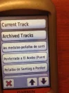
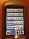
Oh, wait a minute. This is what my screen shows.

gps1.webp gps.webp


I assumed that meant that because the tracks were all listed under the "archived tracks" button, that they were actually stored in that part of the machine. But when I click on archived tracks, it tells me there are no archived tracks. And when I click on current track they tell me there are no current tracks. So this long list of tracks is neither archived nor current, right? That just means they are there for me to use when I need them?
 
3rd Edition. More content, training & pack guides avoid common mistakes, bed bugs etc
Have a super time, Laurie. I enjoyed it very much in May - but it IS a lonely camino. I stayed in four albergues, and was totally alone in three of them!
Links to my Ebro camino and associated photographs are on my web site.
The storks are amazing ... they are everywhere, and I took too many pictures of them!

View attachment 22186

Stephen.
x

Thanks, Stephen, your pictures are great, and I will spend time to read your blog carefully. I see you started in late April. I can't start walking till about May 18-20 and I'm nervous about the heat. I know that things are changing and never the same, but as between this camino and the Mózarabe from Almería, I am hearing enough bad info about heat on the latter camino that I'm definitely leaning towards this one for next year. But it might also be a scorcher. Buen camino, Laurie
 
Oh, wait a minute. This is what my screen shows.

I assumed that meant that because the tracks were all listed under the "archived tracks" button, that they were actually stored in that part of the machine. But when I click on archived tracks, it tells me there are no archived tracks. And when I click on current track they tell me there are no current tracks. So this long list of tracks is neither archived nor current, right? That just means they are there for me to use when I need them?

Laurie, I think you are correct, that is that these tracks are going to be available to use. The etrex30 has a similar approach, although a slightly smaller display. If you scroll down to the track you want and select/open it you should get a screen that includes an option to 'View Map'. Scroll to and select that option. The track should come up on screen with any mapping you have loaded, with a single option bar 'Go'. To navigate the track, select that 'Go' option, otherwise use the 'Back' button to go to the previous page.
 
Laurie, I think you are correct, that is that these tracks are going to be available to use. The etrex30 has a similar approach, although a slightly smaller display. If you scroll down to the track you want and select/open it you should get a screen that includes an option to 'View Map'. Scroll to and select that option. The track should come up on screen with any mapping you have loaded, with a single option bar 'Go'. To navigate the track, select that 'Go' option, otherwise use the 'Back' button to go to the previous page.
So, I have just checked on my machine, and indeed, when I click on any particular stage, it pulls up the map of that stage. This suggests to me that I will be able to use them. But I wonder if you have any ideas about what may have happened to me this year.

About a day before my departure, I opened my gps and couldn't find any of my downloaded tracks, so I frantically went around and re-loaded them. Turns out that I then had more than one copy of each stage, which was confusing and unhelpful. But the more general problem happened again to me -- one day, out of the blue, when I turned on the machine and went to track manager, none of the tracks were there. They all "reappeared" a few days later, but do you have any idea what I could have done to make that happen? Thanks, Doug, Laurie
 
The 2024 Camino guides will be coming out little by little. Here is a collection of the ones that are out so far.
Laurie, until I made a small adjustment to the memory card holder, it would sometimes slide open and the card contacts would not be meeting up with those in the GPS unit itself. This will mean that any information stored on the memory card is inaccessible - maps, tracks, the works. If you have found this happening, eg when replacing batteries, it is possible to tighten the small claws on each side of the metal holder so they the holder is less likely to slip open accidentally. If you want to do this yourself, you will need a small pair of needle-nosed or similar pliers, and be careful! When I did it, I was concerned not to go too far and break the holder.

If this had occurred and you reloaded the track, it might have been that you then had copies of the tracks in both the devices memory and on the memory card, which would have explained the duplicates you later found.
 
@peregrina2000 - Laurie, I have found another source of tracks for all the major routes in Spain on the Centro de Descargas run by the Centro Nacional de Información Geográfica (CNIG). It provides KML files as downloads, which can be imported directly into Basecamp once they have been saved.

I have checked a couple of the early tracks, and the CNIG tracks appear to be the basic route, ie they do not have extensions into towns for accommodation, etc. I also checked a couple of the alignments in Google Earth where there were a couple of legs that appeared unusually straight, and it appears that in at least one place the track goes straight across a ridge line well away from the road network. It appears that at that point, the track provided is not a particularly accurate representation of where you might need to walk. At this point, the tracks that I downloaded the other day are even further away from where you might actually walk. Whichever you use, do so with caution!
 
3rd Edition. More content, training & pack guides avoid common mistakes, bed bugs etc
@peregrina2000 - Laurie, I have found another source of tracks for all the major routes in Spain on the Centro de Descargas run by the Centro Nacional de Información Geográfica (CNIG). It provides KML files as downloads, which can be imported directly into Basecamp once they have been saved.

I have checked a couple of the early tracks, and the CNIG tracks appear to be the basic route, ie they do not have extensions into towns for accommodation, etc. I also checked a couple of the alignments in Google Earth where there were a couple of legs that appeared unusually straight, and it appears that in at least one place the track goes straight across a ridge line well away from the road network. It appears that at that point, the track provided is not a particularly accurate representation of where you might need to walk. At this point, the tracks that I downloaded the other day are even further away from where you might actually walk. Whichever you use, do so with caution!

Hi, Doug, I'm not even sure I understand this post. I have been looking at the tracks that you downloaded and changed to gpx files, and that I then downloaded and they look pretty reliable to me -- can you give me some idea about what looks bad to you? Thanks.

and p.s. alansykes has downloaded all his tracks as well, on wikilocs, so I can use those if it seems prudent
 
Not all of the 'track' actually follows a track on the ground. If one were to try and follow the GPS track, you would be scrub-bashing and crossing a couple of pretty steep ridgelines.

If you look at the track from Xerta to Gandesa, it follows the river for about six km, before heading north west along a stream. Rather than following the bend of the river to its junction with the stream, the GPS track seems to cross straight across the ridge line. It might be that what is intended is to use the tunnel through the ridgeline just before where the track is marked, or the track network just after it. There appear to be other parts of the route that go through tunnels as well. The photographs linked on Google Earth show that while they once might have been used for vehicular traffic, they are now bike and walking paths.

I can only assume that the Via Verde is well enough marked so that you are not likely to be tempted to follow the GPS track religiously at these places.
Thanks, Doug, I have read that there are several long stretches through tunnels. Seems that they have no lighting, and are very long and dark, so it looks like I'll have to bring a good headlamp this year instead of the one I use in albergues. And I'm comparing Alan's tracks from his current walk to the ones I've downloaded and it looks like they are ok. Laurie
 
The one from Galicia (the round) and the one from Castilla & Leon. Individually numbered and made by the same people that make the ones you see on your walk.
Thanks, Doug, I have read that there are several long stretches through tunnels. Seems that they have no lighting, and are very long and dark,

Àll (both? All three?) the long tunnel stretches have motion-activated solar pannelled lighting. It's timed for bicyclists' speed, so you can be plunged into darkness, but there are switches every c100m in the tunnels, which were just visible in the gloom, or with the help of the meagre light of my mobile 'phone.

So it's really not a problem.
 
Laurie, until I made a small adjustment to the memory card holder, it would sometimes slide open and the card contacts would not be meeting up with those in the GPS unit itself. This will mean that any information stored on the memory card is inaccessible - maps, tracks, the works. If you have found this happening, eg when replacing batteries, it is possible to tighten the small claws on each side of the metal holder so they the holder is less likely to slip open accidentally. If you want to do this yourself, you will need a small pair of needle-nosed or similar pliers, and be careful! When I did it, I was concerned not to go too far and break the holder.

If this had occurred and you reloaded the track, it might have been that you then had copies of the tracks in both the devices memory and on the memory card, which would have explained the duplicates you later found.

Doug, a belated thanks for this note. I am virtually certain that's what messed me up last year -- that sometimes when I changed the batteries, the memory card was moved out of contact.

I have successfully downloaded all the GPS tracks you have converted, but have a couple more questions.

First, my memory card has 16 gb, is that a lot or a little? Just wondering whether I have to worry about putting too much on there.

And second, maybe more important, it turns out that I now have, for a lot of the route anyway, two sets of similar tracks. I have alansykes' tracks and the ones you converted. I wonder if this is going to mess me up when I go to find a track. Will I see both of them at the same time or will there be a way to see which one I'm using?

And third, a question about starting out in the morning. I think I have been going to "track manager" to find the track I want to have running, but someone told me I should be using the "where to" button. Is there a difference between these two?

Thanks for your patience, Laurie
Let me address the last question first - it really doesn't matter so far as I can tell unless you want to use an archived track. Both ways will get you to a point where you have the option to use the current saved tracks. Where it does make a difference is if you have used the archive option to remove a track from the 'active' list. The only way to see these, as far as I can tell, is using the Track Manager. They don't appear when starting from the Where To function.

You have a relatively large memory card, certainly more than enough for most map distributions. For example, the OpenStreetMap map set for all of Spain is under 500 MB. All the OpenStreetMap sheets for the whole of the states I crossed on Route 66 (IL, MO, KS, OK, TX, NM, AZ, CA) take up less than 1.5 GB. The tracks themselves are minuscule on this order of things - a few hundred KB each. You shouldn't need more than 10 MB for their storage. If you have a couple of sets of different tracks already, you might start getting up around 50 MB - still plenty of room.

While having a lot of mapping information might seem like a good idea, I find that there are performance issues, and my GPS slows down as it works through all the data that is active, particularly if you use map that have a routing layer included. If this is a issue for you, it might be worthwhile disabling the maps sets you don't want to use.

If you feel you will be confused by the various tracks, you might want to add a prefix to the different sets. Eg, you could prefix Alan Sykes tracks with 'AS'. I suggest prefixing the name because on my etrex30, if the name is too long, the end of the name is not normally displayed. It is possible to do this in Basecamp when the GPS is connected. The alternative is to remove one set of tracks entirely.
 
Last edited:
3rd Edition. More content, training & pack guides avoid common mistakes, bed bugs etc
While having a lot of mapping information might seem like a good idea, I find that there are performance issues, and my GPS slows down as it works through all the data that is active, particularly if you use map that have a routing layer included. If this is a issue for you, it might be worthwhile disabling the maps sets you don't want to use.

Doug, can you explain what it means to use a map that has a "routing layer"? And will it still be slowed down if I choose one particular set of tracks over another when I go to "where to?"

Thanks, Laurie

and a big thanks for all the other info
 
Doug, can you explain what it means to use a map that has a "routing layer"? And will it still be slowed down if I choose one particular set of tracks over another when I go to "where to?"

Thanks, Laurie

and a big thanks for all the other info
Some map sets contain the information about how road and track networks are joined up as well as some other characteristics like how many lanes and which side of the road is used, etc. This information can then be used to plot paths from one place to another. It is at the heart of in-car GPS units, but can be used by a variety of handheld GPS units with the functionality to use that information. Typically this might increase the size of the map data file by 50-100% over a file that doesn't have this information included. So its just so much more data to store and process. Some sources give you the option of including routing information when you download mapping information, other don't.

I see no reason why using 'Where to' or the 'Track Manager' options to get to a track would make using that information any faster or slower. The track is a relatively small data set in any case, and the map information, not the track information, is more likely to slow down displaying the information. You can test this by altering the amount of detail being shown on the map by altering the level of map detail in the map setup, and seeing what information is displayed or removed as you move between settings.
 

❓How to ask a question

How to post a new question on the Camino Forum.

Featured threads

❓How to ask a question

How to post a new question on the Camino Forum.

Featured threads

Forum Rules

Forum Rules

Camino Updates on YouTube

Camino Conversations

Most downloaded Resources

This site is run by Ivar at

in Santiago de Compostela.
This site participates in the Amazon Affiliate program, designed to provide a means for Ivar to earn fees by linking to Amazon
Official Camino Passport (Credential) | 2024 Camino Guides
Back
Top