• Remove ads on the forum by becoming a donating member. More here.

Search 74,075 Camino Questions

Heights-Vertigo issues on the Camino

yukonchick

New Member
Hello all,
I am a Canadian woman, now 59, who will be doing the Camino in 2014 when I am 61. My concerns are not so much the walking, but the heights and inclines as I do have a fear of heights. I've heard horror stories about the Pyrenee crossing (Jane Christmas calls it Hell in her book).

I have lived in mountainous regions of Alaska and the Yukon (Canada), so can handle heights in certain circumstances - but if the incline is so steep as to be like the Gold Rush Chilkoot, straight UP with the possibility of sliding down and into oblivion, then I have to rethink.

I'm the one who went to the pyramids in Mexico only to be unable to climb the steps due to the steepness.

I'm the one who tried to do the Chilkoot, only to turn back after 5 steps as it was too steep and I got vertigo.

Having said that, I have been to the top of the major Towers in the world, lived on a 32nd floor, etc. and they were OK.

But if there is no path, no road, and if I can see Down Below with the incline so steep the mud is touching my nose, I don't stand a hope in hell. If the incline is out in the open, like mountain climbing, I'd like to know!

I have no problem hiking hills and train on a treadmill at the top incline....but it's Vertigo I'm most worried about.

Can someone comment on the incline, vertigo, and whether anyone was paralyzed by it???

Thanks,

Yukon Chick
0-5 posts


Posts: 1
Joined: 07 Apr 2012, 11:25
Location: Yukon, Canada
Private message
 
Train for your next Camino on California's Santa Catalina Island March 16-19
Hi,
Don't worry about it there's nothing so acute that is should bring on your vertigo (at the level you described). If you take the Route Napoleon just don't take the more direct decent down to Roncevalles through the woods which is pretty steep instead go to the monastery via the little road (i.e .turn right).
Oh and definitely avoid the steep flight of steps up or down into Portomarin I felt like an aztec sacrificial victim climbing up the damn things but they provided a short cut into the town - so I was outvoted :(
Have a joyful journey.
 
As a serious vertigo sufferer, I can assure you that I found no problem at all with the crossing of the Pyrenees-- I cannot recall any yawning chasms beside the path. The walk up to O Cebreiro from Ruitelan was very difficult for me, however, and on repeated trips, I have taken a taxi for that stretch.
 
The one from Galicia (the round) and the one from Castilla & Leon. Individually numbered and made by the same people that make the ones you see on your walk.
yukonchick said:
My concerns are not so much the walking, but the heights and inclines as I do have a fear of heights.
Although the Camino Francés between Roncesvalles and Santiago (700 or more kilometers) has quite some up and downs, most of these are not likely to cause vertigo. There are a few dangerous stretches, which can all be circumvented by walking along the main roads.
 
The only descent on the CF where I felt a bit insecure ( not the height but more the rocky surface downwards ) was the walk from El Acebo over Riego de Ambros into Molinaseca. A decent is much more tiring for me than climbing up.
But all in all it is all very doable.
 
To reiterate what the consensus is saying here, you have absolutely nothing to fear. The Camino from SJPP to Roncensvalles may have relatively steep inclines but there are no drop offs whatsoever to be concerned about. The walking trails are very, very wide. It is impossible to go over the edge because there is no edge; rather the mountains are of gentle slopes on the side of the trail as the elevation increases. You have a better chance of being eaten by a grizzly bear than falling over any hillside. And there are no grizzlies in that part of the world.

I am petrified of dropoffs myself. I would never go to the top of a tower nor live on a 32nd floor.

Based on contradictory comments and the overly dramatic descriptions in some of the books and literature that I read in advance as it related to this subject, I considered starting in Pamplona rather than SJPP. I am so glad that I instead chose to listen to those from this forum who said that there was nothing to worry about. I reluctantly therefore did begin in SJPP. That first stage out of SJPP is like no other. I consider it to be the best section of the Camino.

Buen Camino!
 
Ideal sleeping bag liner whether we want to add a thermal plus to our bag, or if we want to use it alone to sleep in shelters or hostels. Thanks to its mummy shape, it adapts perfectly to our body.

€46,-
nellpilgrim said:
I felt like an aztec sacrificial victim climbing up the damn things but they provided a short cut into the town - so I was outvoted :(


Hi Nell!
Thanks so much for your reply....the Aztec comment struck a nerve because those kinds of stairs, found on ruins and pyramids, are just impossible for me. I get vertigo just 2-3 steps up. I have lots of pictures from my travels - from below!

I've spent some time on YouTube looking at some little movies people have put up....there are some of "Day One", though they don't really show too much.

I re-watched The Way last night and while it doesn't show a whole lot, I'm thinking that shot where Tom reaches the makeshift cross just a few miles up, depicting where Daniel died (and where he briefly appears in spirit) is what I have ahead of me. I think I'd freak to have that incline so high up....

I enjoyed your blog, by the way. I read some of it yesterday as this is so new to me, I'm immersing myself in people's stories - knowing full well that my own story will be different.

But being the control freak I am....this is my way of being as prepared as I can be, while not having any control over what I will find. :?
 
oursonpolaire said:
The walk up to O Cebreiro from Ruitelan was very difficult for me, however, and on repeated trips, I have taken a taxi for that stretch.

Sounds reasonable - but my question (from one who hasn't been there yet) is...if it's too steep for us, how can cars manoeuver????
 
fraluchi said:
There are a few dangerous stretches, which can all be circumvented by walking along the main roads.

Thank you for responding!

Is there much vehicular traffic on these main roads? I just read a survey that said the worst drivers in Europe are in Spain, with France a close second.

I would find it ironic to be doing a walking pilgrimmage and be hit by a car. :o
 
The 2024 Camino guides will be coming out little by little. Here is a collection of the ones that are out so far.
SabineP said:
The only descent on the CF where I felt a bit insecure ( not the height but more the rocky surface downwards ) was the walk from El Acebo over Riego de Ambros into Molinaseca. A decent is much more tiring for me than climbing up.
But all in all it is all very doable.

Thanks for writing, Sabine! It helps to hear it's ''doable''...immersing myself in the literature and people's stories, I'm getting the good, the bad and the ugly.

And I admit what I feel most about the whole thing is Excitement and Fear. But I can live with the fear, which I think is healthy to have when one is plunging into the unknown. I just don't want to plunge over a cliff!!
 
yukonchick said:
oursonpolaire said:
The walk up to O Cebreiro from Ruitelan was very difficult for me, however, and on repeated trips, I have taken a taxi for that stretch.

Sounds reasonable - but my question (from one who hasn't been there yet) is...if it's too steep for us, how can cars manoeuver????

The walk up to O' Ceb has a walkingpath for hikers and than there's a parallel road for bikers and cars.
 
markss said:
Based on contradictory comments and the overly dramatic descriptions in some of the books and literature that I read in advance as it related to this subject, I considered starting in Pamplona rather than SJPP. I am so glad that I instead chose to listen to those from this forum who said that there was nothing to worry about. I reluctantly therefore did begin in SJPP. That first stage out of SJPP is like no other. I consider it to be the best section of the Camino.
!

Hi Mark - thanks for responding!

I'm trying to find pictures of the difficult sections...on YouTube and elsewhere...but so far, without much luck.

Having said that, I recognize in myself one who tries to control that which can't be controlled - and I don't want every inch of the trail known in advance or else I will lose the sense of discovery.

The decision to walk the Camino just came this week, but it is a year or so away yet - plenty of time to read others' accounts. I don't know what I'm looking for in this reading...because the experience will be uniquely mine - but I don't want to get there and suddenly see these inclines and vertigo sets in and = voila! I'm stuck with a backpack and no place to go! :shock:

The accounts that say it's doable are great - but one who has scaled Kilimanjaro can also say it is 'doable'', but not for me!!
 
Join the Camino cleanup. Logroño to Burgos May 2025 & Astorga to OCebreiro in June
SabineP said:
The walk up to O' Ceb has a walkingpath for hikers and than there's a parallel road for bikers and cars.


So...if it's difficult...can we use the biking trail for the walk, if it comes down to quitting or going on?? Is there Camino police to keep people on their own trail?
 
yukonchick said:
SabineP said:
The walk up to O' Ceb has a walkingpath for hikers and than there's a parallel road for bikers and cars.


So...if it's difficult...can we use the biking trail for the walk, if it comes down to quitting or going on?? Is there Camino police to keep people on their own trail?

No Camino police at all : it is YOUR walk...
But again that walking trail is steep but there is no way you could fall or something of the likes.
 
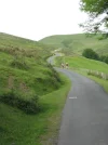
Yukonchick, Quite a bit of the Pyrenees crossing is like this: on a road, not close to any edges. Margaret
 

Attachments

  • Pyrenees.webp
    Pyrenees.webp
    39.5 KB · Views: 948
Train for your next Camino on California's Santa Catalina Island March 16-19
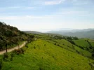
The walk to O' Cebreiro, no major edges either.
 

Attachments

  • IMG_1631 (400x299).webp
    IMG_1631 (400x299).webp
    21.8 KB · Views: 961
As a vertigo sufferer I do wish that those with a fear of heights would not use the term Vertigo to describe Acrophobia (from the Greek: ἄκρον, ákron , meaning "peak, summit, edge" and φόβος, phóbos, "fear"). While I sympathise with the symptoms it is unhelpful and confusing to describe your symptoms as vertigo which is a physiological disorder and not a psychological problem.
 
Actually the only place I got a bit dizzy was on the meseta :shock: Perhaps it's because I come from a place with more restricted horizons (usually hill's/trees in the way) so that BIG sky disorientated me somehow- not in a bad way more like 'space giddiness' really.
I forgot to mention that maybe you should avoid getting up close and personal with statue of the eponymous Virgin at Orisson-as she is perched on a bit of a rocky ledge and that could give you the wobbles.
Otherwise you'll be grand and remember even if you do feel a section is too much you can always take the road option if you feel like it. I'm not an edge jockey at all and found nothing too extreme. We had white out's of snow or mist in many of the high places which also, in a curious way, helped those with some vertigo :lol: .
 
Get a spanish phone number with Airalo. eSim, so no physical SIM card. Easy to use app to add more funds if needed.
BlackDog said:
As a vertigo sufferer I do wish that those with a fear of heights would not use the term Vertigo to describe Acrophobia (from the Greek: ἄκρον, ákron , meaning "peak, summit, edge" and φόβος, phóbos, "fear"). While I sympathise with the symptoms it is unhelpful and confusing to describe your symptoms as vertigo which is a physiological disorder and not a psychological problem.

I appreciate your view, and you are welcome to it, but you are in no position to say which I (or anyone else) suffers from. I believe the psychological can cause the physiological, as well, which further muddies the water. That I have done so much that involves heights, I know there are triggers that render me panicky and immobile. And how that relates to the Camino is the subject of my interest.

I don't care to spend bandwidth discussing terms with you - if this thread isn't something you can or wish to contribute to as far as the challenges on the Camino, so be it.

Best to you.
 
As noted elsewhere on this forum, I strongly dislike tall bridges. I was delighted to note on my recent Camino that the bouncy footbridge on leaving Portomarin was closed, and pilgrims are now directed over the adjacent road bridge. The only remaining major high bridge hazard is on the stage into Leon (maybe Villarente?) where you have the busy road on your right and the guard rail on the left ends some way before the bridge does!

Apart from that, I agree with all the other posts and can't think of anywhere you could fall off a cliff etc. I nearly fell into a ditch once, but I was well refreshed by San Miguel at the time.

Buen Camino!
 
yukonchick said:
I believe the psychological can cause the physiological, as well, which further muddies the water. That I have done so much that involves heights, I know there are triggers that render me panicky and immobile. And how that relates to the Camino is the subject of my interest.
My wife and I have walked the Camino Francés from Roncesvalles to Santiago on several occasions. She suffers vertigo and I can assure you that there was no passage where she became concerned. Yes, there are stretches where you must be careful as to where and how you put your feet. The few existing, difficult passages are properly signposted and protected, but not causing vertigo.
Don't worry, be happy :D
Ultreya!
 
Get a spanish phone number with Airalo. eSim, so no physical SIM card. Easy to use app to add more funds if needed.
yukonchick said:
SabineP said:
The walk up to O' Ceb has a walkingpath for hikers and than there's a parallel road for bikers and cars.


So...if it's difficult...can we use the biking trail for the walk, if it comes down to quitting or going on?? Is there Camino police to keep people on their own trail?

I think, Yukonchick, that you're really worrying too much about this. So much of this is subjective-- I had no trouble with the Sierra de Perdon or the Pyrenees; others do. I had trouble with the Sierra de Loarre (on another Camino) in 2007 but very little in 2009. Relax as you go along, walk with people, and you might not even notice the stretches which troubled me. What is important to remember is that there are alternatives possible if need be.

While the terminology debate is best pursued elsewhere, my GP was not certain if my situation was caused physiologically or psychologically and we agreed that, since I was able to manage challenges, we spare the provincial health system the battery of tests.
 
Although the Camino Francés between Roncesvalles and Santiago (700 or more kilometers) has quite some up and downs, most of these are not likely to cause vertigo. There are a few dangerous stretches, which can all be circumvented by walking along the main roads.

A few dangerous stretches??? What are they? I have an irrational fear of heights. If there are any 'cliffside' moments on the walk, please advise as I become immobilized, extremely panicky, a danger to others. If I know what to expect I'll arrange transportation to avoid those spots. Thank you!
 
A few dangerous stretches??? What are they? I have an irrational fear of heights. If there are any 'cliffside' moments on the walk, please advise as I become immobilized, extremely panicky, a danger to others. If I know what to expect I'll arrange transportation to avoid those spots. Thank you!
Hi j4jan
I didn't walk the entire Frances, but I think there are no cliffs. I met more than one walker who was blind, and have read of one in a wheelchair. whew.
sometimes the road can be slippery if there is ice or lots of rain...fall onto you rear or nose slippery, not fall to your death. A pilgrim did recently fall (maybe 3 or 4 years ago) between SJPdP and Roncessvalles, breaking her arm, but I believe she was wandering in a snowstorm. Another died maybe 5 or 6 years ago doing the same thing. If it is snowing, people are told to take the Valcarlos route (both of these above were on Napoleon)...because the road there is passable in bad weather. Anytime the weather would make the road seem too slippery, there is always an alternative, either take the route marked for bikes, or a cab, or a bus, or let the weather change.
The only spot I've seen many complain about (and I walked it and would agree) is it is a steep decent from the Cruz de Ferro into Molinaseca. Not fall to your death, just hard on the knees. But it would be quite adrenaline producing on a bike.
anyway, here is a couple of websites (in Spanish, translatable with Google) just click on the route you will be taking (frances, norte, etc) then click on each step, and you will see the distances between albergues, and the elevations (up and down) and comments about any tricky spots, and pictures.
You will be fine!
Buen Camino

edit: the road to Molineseca would be adrenaline producing on a bike because you could get going quite quickly and it is very winding (and you share with cars) . The walkers have their own path. at no time are you clinging to cliffs, or walking on a narrow strip of earth with a canyon below
 
Last edited:
Train for your next Camino on California's Santa Catalina Island March 16-19
A few dangerous stretches??? What are they? I have an irrational fear of heights. If there are any 'cliffside' moments on the walk, please advise as I become immobilized, extremely panicky, a danger to others. If I know what to expect I'll arrange transportation to avoid those spots. Thank you!

Fellow vertigo sufferer here, the only, for me, dangerous bit were some stepping stones over a stream near Zubiri/Larrasoaña but they could be easily avoided by taking the road option a couple of meters to the left. Otherwise no problems at all and I have severe vertigo (can't even climb a chair without problems).

So, Buen Camino, SY

PS I also always told the albergues about my vertigo and, together with my greyish hair, always got a lower bunk bed.
 
I was hoping @SYates would chime in (but didn't want to 'out' her)....
Another thing to consider, perhaps get walking poles and practice (a lot) with them before you go. They are good for helping steady yourself if the road is a bit steep or slippery, crossing over streams, etc
 
3rd Edition. More content, training & pack guides avoid common mistakes, bed bugs etc
I didn't walk the entire Frances, but I think there are no cliffs.
I do not remember any cliff spots on the Frances either but there are a number of steep spots (both up and down.) These can be tricky when there are wet rocks, mud or gravel. A number are on roads or road width trails and zig-zagging can reduce the pitch (and increase the travel time.) Others can just be approached carefully and some can by-passed. The ones on the Frances that I remember being complained about frequently on the forum are:
  • The last half of the Roncevalles to Zubiri stage is also steep. The highway could be taken instead. Choose between the possibilities of slipping or getting hit by a car.
  • The descent from the Alto de Pedron. Steep with rocks and gravel but wide enough for ziz-zags.
  • There has recently been talk on the forum about a new steep bit before Portomarin.
 
(why didn't @Smallest_Sparrow remember this?)
I remember it:p but the only way you end up on it is either ignoring the instruction to avoid it, or, as some of us experienced, get lost in a snow storm and miss the 8 foot tall sign pointing in the other direction. But yes, I can say, if you walk Napoleon watch for the big wood signpost to take the road to the right near the top...still, it is not cliff-like, just steep and slippery in snow.
 
The one from Galicia (the round) and the one from Castilla & Leon. Individually numbered and made by the same people that make the ones you see on your walk.
"Dangerous" here means that you could slip and break your arm or twist an ankle. The only thing approaching a "cliffside moment" is the bridge into Portomarin, if you are crossing when the reservoir is low (e.g. in the late fall). When the reservoir is high in the spring it is just an ordinary bridge. Look at this thread.
 
Also the bridge, which has handrails btw, can be navigated by keeping your eyes firmly on the tarmac and not looking down to the river/lake. Buen Camino, SY
 
Fellow vertigo sufferer here, the only, for me, dangerous bit were some stepping stones over a stream near Zubiri/Larrasoaña but they could be easily avoided by taking the road option a couple of meters to the left. Otherwise no problems at all and I have severe vertigo (can't even climb a chair without problems).

So, Buen Camino, SY

PS I also always told the albergues about my vertigo and, together with my greyish hair, always got a lower bunk bed.

Thank you, SY. Maybe I should stop 'highlighting' now. :)
 
3rd Edition. More content, training & pack guides avoid common mistakes, bed bugs etc
Hi j4jan
I didn't walk the entire Frances, but I think there are no cliffs. I met more than one walker who was blind, and have read of one in a wheelchair. whew.
sometimes the road can be slippery if there is ice or lots of rain...fall onto you rear or nose slippery, not fall to your death. A pilgrim did recently fall (maybe 3 or 4 years ago) between SJPdP and Roncessvalles, breaking her arm, but I believe she was wandering in a snowstorm. Another died maybe 5 or 6 years ago doing the same thing. If it is snowing, people are told to take the Valcarlos route (both of these above were on Napoleon)...because the road there is passable in bad weather. Anytime the weather would make the road seem too slippery, there is always an alternative, either take the route marked for bikes, or a cab, or a bus, or let the weather change.
The only spot I've seen many complain about (and I walked it and would agree) is it is a steep decent from the Cruz de Ferro into Molinaseca. Not fall to your death, just hard on the knees. But it would be quite adrenaline producing on a bike.
anyway, here is a couple of websites (in Spanish, translatable with Google) just click on the route you will be taking (frances, norte, etc) then click on each step, and you will see the distances between albergues, and the elevations (up and down) and comments about any tricky spots, and pictures.
You will be fine!
Buen Camino

edit: the road to Molineseca would be adrenaline producing on a bike because you could get going quite quickly and it is very winding (and you share with cars) . The walkers have their own path. at no time are you clinging to cliffs, or walking on a narrow strip of earth with a canyon below
 
Thank you, SY. Maybe I should stop 'highlighting' now. :)
don't. they also ask your age when you check in. You could always add a decade or two, just to ensure that lower bunk
 
Thanks so much for your advice, Smallest-Sparrow. Much appreciated!
don't. they also ask your age when you check in. You could always add a decade or two, just to ensure that lower bunk
Lol. I don't think I'll need to 'add a decade or two'. Oh, the $ I'll save non-highlighting!
 
Perfect memento/gift in a presentation box. Engraving available, 25 character max.
The 2024 Camino guides will be coming out little by little. Here is a collection of the ones that are out so far.
I do not remember any cliff spots on the Frances either but there are a number of steep spots (both up and down.) These can be tricky when there are wet rocks, mud or gravel. A number are on roads or road width trails and zig-zagging can reduce the pitch (and increase the travel time.) Others can just be approached carefully and some can by-passed. The ones on the Frances that I remember being complained about frequently on the forum are:
  • The last half of the Roncevalles to Zubiri stage is also steep. The highway could be taken instead. Choose between the possibilities of slipping or getting hit by a car.
  • The descent from the Alto de Pedron. Steep with rocks and gravel but wide enough for ziz-zags.
  • There has recently been talk on the forum about a new steep bit before Portomarin.
Aha! Found the sites. Thank you; new at this. This looks amazing...so detailed...excellent!!
 
3rd Edition. More content, training & pack guides avoid common mistakes, bed bugs etc

❓How to ask a question

How to post a new question on the Camino Forum.

Most read last week in this forum

I saw a video with a rather harsh criticism of a small, municipal albergue on one of the less traveled caminos. They paid 9€. I thought: What does it cost a small municipality to renovate and keep...
On my last Camino (2023) I noticed that there were lots of tourists. It reminded me of a couple of quotes that I have read since my first Camino (2015) “A tourist demands, a pilgrim is grateful”...
"A complete guide to the world's greatest pilgrimage"[sic] by Sarah Baxter. In a British newspaper, The Telegraph. A right wing daily that does print interesting articles and essays...
Day 42 Week 6 460km walked (give or take) Today I had a revelation, an epiphany and a Divine Intervention... all in one day. Today the exreme pain in my soul is dissipating some... healed by the...
There was a recent thread about EST (Erhard Seminars Training) which I have to say I have never hear of, but it got me thinking. I undertook some rather 'left field' training about 10 years ago...
I've been trying to figure out how to use the Gronze app and as a first step I need to translate into English - I searched topics on the Forum, thought I found what I was looking for, and Yay! I...

Featured threads

❓How to ask a question

How to post a new question on the Camino Forum.

Featured threads

Forum Rules

Forum Rules

Camino Updates on YouTube

Camino Conversations

Most downloaded Resources

This site is run by Ivar at

in Santiago de Compostela.
This site participates in the Amazon Affiliate program, designed to provide a means for Ivar to earn fees by linking to Amazon
Official Camino Passport (Credential) | 2024 Camino Guides
Back
Back
Top