• Remove ads on the forum by becoming a donating member. More here.

Search 74,075 Camino Questions

Gronze’s GPS tracks

Robo

Veteran Member
Time of past OR future Camino
Frances 15,16,18
VdlP 23, Invierno 23, Fisterra 23
I used Maps.me for my whole journey on the VdlP and Invierno. Loved it.
I downloaded each days track from gronze.
So easy to just glance at the map and see where I was in relation to the Camino path or variant.
I didn't really need to look for arrows or anything......

Free app, free track downloads from Gronze.
 
Last edited:
Get a spanish phone number with Airalo. eSim, so no physical SIM card. Easy to use app to add more funds if needed.
I used Maps.me for my whole journey on the VdlP and Invierno. Loved it.
I downloaded each days track from gronze.
So easy to just glance at the map and see where I was in relation to the Camino path or variant.
I didn't really need to look for arrows or anything......

Free app, free track downloads from Gronze.
I’m using Gronze, but as far as I can tell, the track downloads feature is not yet available for Apple phones.
 
I’m using Gronze, but as far as I can tell, the track downloads feature is not yet available for Apple phones.

Really? When I down load a track, it has a pop up that asks if I want to open the file.
It then asks what app I want to use.
And I pick maps.me.
Can you use maps.me on iphone?
looks like you can. https://maps.me/
Sorry, I'm not that tech savvy so not sure if the android version v the iphone version of maps.me uses different track file formats.

Afterthought.

Did you not see the option to download tracks, or it said not available?
Because it's not obvious where to look.

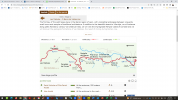
Step 1. On the initial view, having selected a Camino and a stage, you see the stage elevation profile below the map.

1687501688227.png

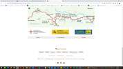
Step 2. Scroll to the bottom of the page and click on route.


1687501783104.png

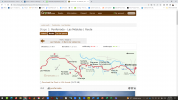
Step 3. Now below the map you have an option to download the 'track'.
you have to register (no cost) to do that.

1687501873247.png
 
The 2024 Camino guides will be coming out little by little. Here is a collection of the ones that are out so far.
It looks like there is no longer an option to download a track from Gronze :-(
Great pity as I liked using it on maps.me

We now have to use their own maps 'app'.

Just had a quick look.
Oh dear, Why did they bother?

On maps.me there was loads of great functionality and additional information on the maps.
All this app seems to do, is show the track.........on a map.
With accomodation that they include on their site.
No search function, nothing 😟
Can't look for a cafe.
Distance to a destination.
None of that that Maps.me provides.

Back to square one.
Looking for a source of good / reliable tracks to download.

I moved away from Wikiloc as there are so many tracks, how would you know which ones to pick?
Which ones are accurate?

I liked Gronze tracks as there was just one...........the right one.
No longer available it seems 😟

Hopefully I am wrong and have missed something.
Otherwise half of the value of Gronze, for me at least has just been wiped out......
"Not Happy Jan"!
You need to be an Aussie to understand that term...........

 
Last edited:
Interesting @Robo. I've been using Gronze for 13 years and never knew it had that function but then again I never used any track app until walking the Olvidado this past summer when I used Wikiloc. I chose that one as Ender (Cuñarro in real life and Enderjace on Wikilocs) made tracks for the whole route. He is the one who helped bring the San Salvador and Olvidado back to life. Frankly I was very happy when I continued onto the Invierno as I could just follow the arrows 😊
 
Back to square one.
Looking for a source of good / reliable tracks to download.
You could try the Spanish Mapping agency, CNIG. They have a wealth of the Camino routes in .kml files here.

Which ones are accurate?
Impossible, in my view to know. It doesn't take much to change the route in even some minor way to make the best efforts of surveyors and cartographers 'out of date'. I know the maps for my car GPS get updated at least every six months, with some urgent updates more frequently. Outside of the cities, the pace of change in Spain and Portugal might not be that rapid, but it there will be changes nonetheless.
 
A selection of Camino Jewellery
liked Gronze tracks as there was just one...........the right one.
I think it is impossible to be sure that Gronze, or any other source, has the absolutely up to date and correct tracks. As @dougfitz points out, the routes are tweaked and modified almost continuously. Gronze probably got the tracks from someone else or from lots of other people who contributed. As @LTfit pointed out in a recent Olvidado discussion, even the tracks of @enderjace, the man who personally put up the arrows and the mojones for the entire route, are occasionally out of sync with what’s on the ground. That’s inevitable.

I moved away from Wikiloc as there are so many tracks, how would you know which ones to pick?
Which ones are accurate?
This is no different that asking yourself — how do I know how to choose from among gronze, wise pilgrim, buen camino, ninja, etc? If you start playing around with wikiloc, you will see that there are “repeat offenders” who have recorded many camino trails. They are my default — rocjumper, enderjace, etc. And if you compare two or three sets of tracks for the same stages, you will usually see that they are virtually identical - not always, but usually. One thing you can be sure of, is that the person who recorded the wikiloc track got from the starting point to the ending point, which is really the most crucial thing. And the one advantage of wikiloc over the other apps, I think, is that you can always see the date on which the track was actually recorded. The more recent the better, of course.

For people who want to have just one continuous track, wikiloc is a lot more labor-intensive because the absolute best way to use it is to go stage by stage. Before I walk, I have a list on my app that includes a track or two for all stages of the route I will walk. Then when I am actually there, I have two or three days out loaded up with offline tracks for each stage. I always make a point of having several different sets of tracks for each stage, and I always try to get one that was recorded within the last year or so. That way, in the event that the route has changed, I can flip back and forth among the tracks I’ve downloaded and see what they do at that particular point. There are times when anyone using any GPS track is going to have to choose between the arrows and the GPS. I will usually go with the arrows, particularly if they are freshly painted. But I can always consult my GPS track to make sure that I am heading in the right general direction, because I know with certainty that the author of my tracks got to the destination.

I’m not trying to push Wikiloc on anyone, but I think that no matter what set of tracks you use, you are likely to have problem points (and I am talking here mainly about remote, untraveled caminos). For me, at those problem points, I like to have several options on my app so I can make the best guess possible.
 
@peregrina2000 and I spent quick a bit of time discussing our different approaches to map apps, while walking the Lana a few months ago. There are some definite advantages and disadvantages of each app. While I initially hoped I could just find one app that did everything for me, I came to realize that using several apps was really not any different from using several features on a single app.

If all the following seems overwhelming, perhaps you are at a stage where the simplest single app is best for you. After you get more comfortable with that, you can always consider some of the following variations. If you are walking a popular route for which custom apps are available, they should suffice. The following is probably more relevant to detailed planning of less popular routes.

Google maps
Like most people, I use this at home and in Spain for up-to-date information on restaurants, hotels, business, etc., especially in towns and cities, or for quick estimates of distances for places that I don't have route maps for.

Organicmaps.app
This is an offshoot from the original Maps.me which I happily used in the past before they made some major changes a couple of years ago.

First, I download to Organic Maps on my phone, the set of "All Caminos in Spain" from the Dutch association . They also have routes from elsewhere in Europe. I love having this master map for quick reference and day dreaming, and I also have it on Google Earth on my computer. When I am planning the details of a specific camino, I first go to the local Amigos website to see if they have a downloadable track and I compare it. I may or may not bother to keep a duplicate map - at least it informs me that the suggested route is the same.

What I really like about Organicmaps is the ease with which I can annotate the maps with my own information and comments. I can drop pins anywhere on the map (not just on a track) to show places of interest, accommodation (including contact info or any notes I want to add), places that might be very muddy in the rain, or even comments about where I found this alternative track.

Organicmaps is like my master atlas and personal reference guide.

Wikiloc
I use Wikiloc to find alternative tracks to put on my Organicmaps for comparison. If I like the additional info, I leave the track on Organic and note where I got the track and its name. I also put the track on a Wikiloc list and make it available for offline use so I can easily access it on the Camino.

I use Wikiloc to record my daily walks, but I generally keep them private; since I'm always following another track, my own track is redundant for others. Something that Wikiloc does that I did not expect to like, was the beeping alert when you are following a Wikiloc track and go off-track. This was very helpful a number of times on the Lana and I am a total convert to its use. (Maybe turn off the sound when you are wandering off the official track in a town.) However, you must have a Wikiloc track in order to use this. I suspect that most of the Camino associations have also uploaded their tracks to Wikiloc, so it is worth finding them from among the many other tracks.

I'm not sure that I agree with @peregrina2000 that "the absolute best way to use it (Wikiloc) is to go stage by stage". If a multi-stage track is available, it is simpler, provided the resolution is adequate (as the recent tracks do seem to be). For the Requena-Lana, I used a single KML track from Valencia to Burgos that was available from the association and that was also found on Wikiloc. I found the accuracy of this single map to be just as good as the piecemeal maps of each stage, and I didn't need to fuss with different maps before starting each morning. I also had the track on Organicmaps with annotations for reference and comparison with route alternatives that I had found. However, I followed the track and recorded my walk on Wikiloc; you can do this recording and save your own track on a daily basis even if you are following a longer track. Even while following the Wikiloc track, I would occasionally switch to check/compare something on my Organic master map.

Some of the Wikiloc features might be available only if you have the premium paid version. However, the price is a very minimal, and it seems like a worthwhile contribution to a group that is doing good work.
 
Last edited:
I'll put in my pitch for mapy.cz. The Camino trails (and many other walking/cycling/hiking trails) are built into the app. Even less traveled routes like the Lana. It's not necessary to download tracks. And you can download the maps for the areas that you will be in for offline use.
 
Last edited by a moderator:
€2,-/day will present your project to thousands of visitors each day. All interested in the Camino de Santiago.
Some good thoughts and feedback, many thanks.
Sorry to rant a bit. :oops:

I suppose I was looking for a 'simple' solution.
And after trying many of the Camino apps, and wikiloc, I found the Gronze tracks to be the easiest to use and in most cases very accurate, on the VdlP, Invierno and Fistrerra this year.
One source, that seemed to do all I needed.
Gronze track on maps.me
And the tracks were usually very up to date.

It just means if I am to use the Gronze 'app' now for tracks. I still need to use something else to gain additional information along the way, that is not included on the app. (until now, maps.me with a Gronze track gave me a one stop shop)

Probably I'll use google maps for general information.

It's like finding your favourite trail shoes are now a new and 'improved' design that are no longer comfortable :rolleyes:

I'll certainly check the other tools mentioned, but even rereading this thread they seem to involve a bit of faffing about. Knowing whose tracks are good etc. :) I suppose in part it depends if you 'enjoy' that part of planning and navigation.
 
Last edited:
even rereading this thread they seem to involve a bit of faffing about.
It is true that to find the best combination for your personal way of managing the map apps, does require some trial and error. I see a definition of "faffing about" as being spending time doing things in a way that is not well organized and that does not achieve much. Like so many learning challenges, it takes some time and patience to organize the concepts and achieve what you want. :)

Anyone who wants only a quick and easy solution should go with one of the packaged apps that meets the top-priority requirements. I recommend that for people beginning the process. However, if you are ready to go the next step, there are options and additions that can be quite interesting and useful. There is no one-size fits all, or one app that is the holy grail.

Let's face it, the software on our computers and phones is not going to stay as it is, for the rest of our lives. It will change tomorrow and every day thereafter. At some point I will likely give up the battle and ask my kids to just set up my devices so I don't have to think at all. I haven't quite reached that point yet, but I also know to pace my learning to my needs and interests.
 
Last edited:
A selection of Camino Jewellery
I suppose I was looking for a 'simple' solution.
And after trying many of the Camino apps, and wikiloc, I found the Gronze tracks to be the easiest to use and in most cases very accurate, on the VdlP, Invierno and Fistrerra this year.
One source, that seemed to do all I needed.
Gronze track on maps.me
And the tracks were usually very up to date.
I think we are all looking for something simple and easy to use. I have several apps, both general purpose mapping apps and specialist camino apps, but I don't want to be flicking back and forth between them when I am on the road. I have pretty much settled on WisePilgrim and OSMAnd+.

For me, WisePilgrim stands out for its usability. I don't think the underlying functionality is too much different from other specialist apps, but those functions that I need are easy to access and use. The developer is also quick to address reported issues, as I experienced this year on the Sanabres route.

OSMAnd+, along with other general mapping apps that use the OSM mapping data, already has the walking routes included as a layer in the data set. Unfortunately, it doesn't reveal what sources were used, but OSM is supported by a crowd sourcing approach to stay up to day with details like this. I also downloaded tracks from other sources so I could compare the OSM tracks layer with those sources. There were minor variations in a few places, but when I am walking, I tend to trust the way marking in any case. I think I would find a wikiloc style off-route audible alert quite distracting.

While I have from time to time compared specialist camino apps, I haven't consistently tried to compare the general purpose mapping apps. I suspect that it's really a matter of finding one that works for you and has the functionality you want, and staying with that. Each of them require some effort to acquire the skills needed to use them competently, and that's not going to easy. And it is clear from the discussion that there are several different ones that members I know to have some experience using mapping apps are using and recommend. You probably won't go wrong with any one of these, you'll just leave others wondering why you didn't have the good sense to follow their own recommendations!
 
@peregrina2000 and I spent quick a bit of time discussing our different approaches to map apps, while walking the Lana a few months ago. There are some definite advantages and disadvantages of each app. While I initially hoped I could just find one app that did everything for me, I came to realize that using several apps was really not any different from using several features on a single app.

If all the following seems overwhelming, perhaps you are at a stage where the simplest single app is best for you. After you get more comfortable with that, you can always consider some of the following variations. If you are walking a popular route for which custom apps are available, they should suffice. The following is probably more relevant to detailed planning of less popular routes.

Google maps
Like most people, I use this at home and in Spain for up-to-date information on restaurants, hotels, business, etc., especially in towns and cities, or for quick estimates of distances for places that I don't have route maps for.

Organicmaps.app
This is an offshoot from the original Maps.me which I happily used in the past before they made some major changes a couple of years ago.

First, I download to Organic Maps on my phone, the set of "All Caminos in Spain" from the Dutch association . They also have routes from elsewhere in Europe. I love having this master map for quick reference and day dreaming, and I also have it on Google Earth on my computer. When I am planning the details of a specific camino, I first go to the local Amigos website to see if they have a downloadable track and I compare it. I may or may not bother to keep a duplicate map - at least it informs me that the suggested route is the same.

What I really like about Organicmaps is the ease with which I can annotate the maps with my own information and comments. I can drop pins anywhere on the map (not just on a track) to show places of interest, accommodation (including contact info or any notes I want to add), places that might be very muddy in the rain, or even comments about where I found this alternative track.

Organicmaps is like my master atlas and personal reference guide.

Wikiloc
I use Wikiloc to find alternative tracks to put on my Organicmaps for comparison. If I like the additional info, I leave the track on Organic and note where I got the track and its name. I also put the track on a Wikiloc list and make it available for offline use so I can easily access it on the Camino.

I use Wikiloc to record my daily walks, but I generally keep them private; since I'm always following another track, my own track is redundant for others. Something that Wikiloc does that I did not expect to like, was the beeping alert when you are following a Wikiloc track and go off-track. This was very helpful a number of times on the Lana and I am a total convert to its use. (Maybe turn off the sound when you are wandering off the official track in a town.) However, you must have a Wikiloc track in order to use this. I suspect that most of the Camino associations have also uploaded their tracks to Wikiloc, so it is worth finding them from among the many other tracks.

I'm not sure that I agree with @peregrina2000 that "the absolute best way to use it (Wikiloc) is to go stage by stage". If a multi-stage track is available, it is simpler, provided the resolution is adequate (as the recent tracks do seem to be). For the Requena-Lana, I used a single KML track from Valencia to Burgos that was available from the association and that was also found on Wikiloc. I found the accuracy of this single map to be just as good as the piecemeal maps of each stage, and I didn't need to fuss with different maps before starting each morning. I also had the track on Organicmaps with annotations for reference and comparison with route alternatives that I had found. However, I followed the track and recorded my walk on Wikiloc; you can do this recording and save your own track on a daily basis even if you are following a longer track. Even while following the Wikiloc track, I would occasionally switch to check/compare something on my Organic master map.

Some of the Wikiloc features might be available only if you have the premium paid version. However, the price is a very minimal, and it seems like a worthwhile contribution to a group that is doing good work.
This is a very useful post. Thank you! It has saved me a load of work, and reminded me what I sort of used to do when I went a-caminoing before Covid. I'm planning to do some new Caminos this year and possibly revisiting an old one at the moment, body willing, so very helpful stuff :-) .
 

❓How to ask a question

How to post a new question on the Camino Forum.

Most read last week in this forum

I came across this in my daily reading. It may be of interest to our peregrinas. It seemed very clever to me. See the article here: https://adventure.com/review-gnara-hiking-trousers/ Also...
Am busy doing a spring clean/room tidy and having a look at my travel/camino clothes, took photos just for fun...for my next future travels. Missing the long sleeve merino, as am looking at an...
OK, here is a question for the Tech savvy folks...... I'm trying to track down some noise cancelling ear buds for use on our flight to the Camino. And will probably also use in Albergues...
Looking for recommendations. I dislike sleeping bags. I’m also not fond of sleeping bag liners. I own one of each and carried them on all my Camino's but I don't think I ever once slept in them...
Hi there! A few months ago, whilst doing first aid training our instructor mentioned that there were personal, one-use AED defibrillators on the market suitable for carrying in a back-pack. I...
I will be doing the Camino Frances in May/June 2025. I’m trying to decide between Hoka Challengers and Merrill Accentors. The Challengers don’t seem to have a very robust sole as the middle part...

Featured threads

❓How to ask a question

How to post a new question on the Camino Forum.

Featured threads

Forum Rules

Forum Rules

Camino Updates on YouTube

Camino Conversations

Most downloaded Resources

This site is run by Ivar at

in Santiago de Compostela.
This site participates in the Amazon Affiliate program, designed to provide a means for Ivar to earn fees by linking to Amazon
Official Camino Passport (Credential) | 2024 Camino Guides
Back
Back
Top