-
 ⚠️ Emergency contact in Spain - Dial 112 and AlertCops app. More on this here.
 -
Remove ads on the forum by becoming a donating member. More here. -
Get your Camino Frances Guidebook here.
Search 74,075 Camino Questions
You are using an out of date browser. It may not display this or other websites correctly.
You should upgrade or use an alternative browser.
You should upgrade or use an alternative browser.
GPX for alternate route from (Irache through Luquin)?
- Thread starter WGroleau
- Start date
Ideal pocket guides for during & after your Camino. Each weighs only 1.4 oz (40g)!
- Time of past OR future Camino
- Too many and too often!
I don't know about a track for that route alone but the alternative via Luquin is one of the many in the "All Pilgrimage Routes Spain" file from this Dutch website. In gpx and kml formats (I am using the kml version).

 www.santiago.nl

Downloads - Santiago
Indeling – Per land vind je hier een overzicht van praktische downloads voor onderweg, ingedeeld in onderstaande drie categorieën. Handleiding – Wil je meer weten over hoe je de bestanden samen met een geschikte app in je smartphone kunt installeren, lees dan de handleidingen. Overzicht – Alle...
 www.santiago.nl
3rd Edition. More content, training & pack guides avoid common mistakes, bed bugs etc
- Time of past OR future Camino
- Various routes 2016 - 2024
Yes, it's on mapy.cz.I think that route is marked in the mapy.cz app, at least i used that in 2021 to go via Luquin

Also on Wise Pilgrim

And Buen Camino

When I walked that way in 2019 it was marked.
- Time of past OR future Camino
- Too many and too often!
It was pretty well marked when I walked that way in January this year.When I walked that way in 2019 it was marked.
The first edition came out in 2003 and has become the go-to-guide for many pilgrims over the years. It is shipping with a Pilgrim Passport (Credential) from the cathedral in Santiago de Compostela.
Anhalter
Veteran Member
- Time of past OR future Camino
- 2019 CF, 2022 CF, 2024 Primitivo
It is well marked and both times i walked it i loved it. It should be in the "buen camino" app as well. As are most other alternative routes. There is another which i know is not in the app, called Ruta Dragonte, from Villafranca del Bierzo to Las Herrerias. Also incredibly beautiful, but by all chance the hardest section of any of the CF. The gpx file and a description can be found with google.
The focus is on reducing the risk of failure through being well prepared. 2nd ed.
- Time of past OR future Camino
- Too many and too often!
The Dragonte is one of the routes in the file I mentioned in post #3 above.There is another which i know is not in the app, called Ruta Dragonte, from Villafranca del Bierzo to Las Herrerias.
WGroleau
Wandering Weirdo aka 伟思礼
- Time of past OR future Camino
- 2015–2018 (partial)
I pulled the "Garmin" and KML files, but neither contained a track, only way points showing albergues. The file ET06 downloaded from here contains variants, but not the one through Luquin.I don't know about a track for that route alone but the alternative via Luquin is one of the many in the "All Pilgrimage Routes Spain" file from this Dutch website. In gpx and kml formats (I am using the kml version).

Downloads - Santiago
Indeling – Per land vind je hier een overzicht van praktische downloads voor onderweg, ingedeeld in onderstaande drie categorieën. Handleiding – Wil je meer weten over hoe je de bestanden samen met een geschikte app in je smartphone kunt installeren, lees dan de handleidingen. Overzicht – Alle...www.santiago.nl
...and ship it to Santiago for storage. You pick it up once in Santiago. Service offered by Casa Ivar (we use DHL for transportation).
- Time of past OR future Camino
- Past: a few. Last: Gudbrandsdalsleden. Next: TBC
The CNIG has a track that might suit your purpose here. You need to open up the listing for the Camino Frances and find the track from Villatuerta-Luquin.
WGroleau
Wandering Weirdo aka 伟思礼
- Time of past OR future Camino
- 2015–2018 (partial)
When I wrote "Irache," I was thinking of the bodega & monastery. This one takes a wide detour around Estella and joins the path I wanted further on at the village of Irache.The CNIG has a track that might suit your purpose here. You need to open up the listing for the Camino Frances and find the track from Villatuerta-Luquin.
WGroleau
Wandering Weirdo aka 伟思礼
- Time of past OR future Camino
- 2015–2018 (partial)
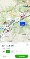
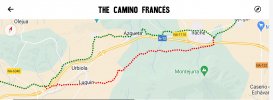
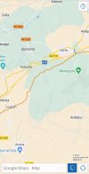
I found a GPX track from one of my walks, and combined it with parts of the ET06 I got here to create a track from Alto del Perdón to Luquin. Smoothed out the jitter a little, and attached it here. Also displayed it on a map at https://HappyHobo.net/Luquin.html You can select from a lot of different map types in the upper right corner. The timestamps are bogus—since ET06 stretched over days, and my part was on bicycle, I re-wrote the times to make the average speed four kilometers per hour. But since the distance between points varies, it makes the speed also vary widely.Anyone aware of a downloadable GPX file for the "alternate" route from Irache through Luquin?
(Or any other alternates—but Irache to Luquin is what I am looking for right now.)
Attachments
Last edited:
Ideal pocket guides for during & after your Camino. Each weighs only 1.4 oz (40g)!
- Time of past OR future Camino
- Past: a few. Last: Gudbrandsdalsleden. Next: TBC
I think that if you walked to the bodega and then onto the village, you would be able to easily pick up the track. The two CNIG tracks for this section come within about 300m of each other at the eastern edge of Irache, and depending on the map source I use, there is a well defined track at that point that goes across to and under the A-12. You will need to do that anyway. I didn't think you would follow the alternative from Vilatuerta, but pick it up around Irache once you had visited the bodega. If you don't know how to select the bits from the different tracks that you think you want to walk, there should be no problem having both of them loaded into whatever mapping app you are using, and just be careful about where you make the transition from one to the other.When I wrote "Irache," I was thinking of the bodega & monastery. This one takes a wide detour around Estella and joins the path I wanted further on at the village of Irache.
- Time of past OR future Camino
- Past: a few. Last: Gudbrandsdalsleden. Next: TBC
The track you have mashed up does vary slightly from the CNIG track once it crosses under the A-12. Your track gets further away from the A-12 at that point, but the two tracks come together about 1.4 km further west and stay together until Luquin.I found a GPX track from one of my walks, and combined it with parts of the ET06 I got here to create a track from Alto del Perdón to Luquin.
MarkyD
Active Member
- Time of past OR future Camino
- Camino Francés 31/08/2018 - 20/10/2018
I walked this route with two other people (Derren and Denise) who I had met at the "junction" just after Irache Bodega in 2018. It was a route less travelled, that felt like walking through an enchanted forest at first! We didn't have maps or use GPS, it was signposted and the path was good. There were no bars along the way, it was just dirt track all the way along the "Variante de Montejurra" to Luquin. We thorougly enjoyed it for its peace and tranquility.Anyone aware of a downloadable GPX file for the "alternate" route from Irache through Luquin?
(Or any other alternates—but Irache to Luquin is what I am looking for right now.)
Tip: Stop for a few minutes to visit the blacksmiths forge and workshop at Ayegui, where you can also get a lovely stamp for your first 100km on the CF.
The focus is on reducing the risk of failure through being well prepared. 2nd ed.
WGroleau
Wandering Weirdo aka 伟思礼
- Time of past OR future Camino
- 2015–2018 (partial)
The part from Estella to Luquin is a path I actually walked. From Alto del Perdón to Estella was copied out of the track downloaded from here. My part did go through the fork just past Irache where the sign (next to a large rock) points both ways. I don’t know what CNIG is, but if I got off “the” path, it’s because I came to a fork that was not marked.The track you have mashed up does vary slightly from the CNIG track once it crosses under the A-12. Your track gets further away from the A-12 at that point, but the two tracks come together about 1.4 km further west and stay together until Luquin.
WGroleau
Wandering Weirdo aka 伟思礼
- Time of past OR future Camino
- 2015–2018 (partial)
I’ve had a few good chats with the blacksmith. One of his creations inspired me to design a set of book ends that he made for me (€160).Tip: Stop for a few minutes to visit the blacksmiths forge and workshop at Ayegui, where you can also get a lovely stamp for your first 100km on the CF.
Attachments
- Time of past OR future Camino
- Recent:Norte/Muxia- Spring '23
MadridWay- Fall '23
I stayed in Luquin at the brand new albergue in 2017 after the Dutch run Monjardin albergue on the main route I loved two years earlier was full. I would not hesitate in trying the alternative route to Luquin if I ever walk the Frances route again; I assume it is a less busy alternative.
Get a spanish phone number with Airalo. eSim, so no physical SIM card. Easy to use app to add more funds if needed.
- Time of past OR future Camino
- Past: a few. Last: Gudbrandsdalsleden. Next: TBC
CNIG is the Spanish mapping agency - Organismo Autónomo Centro Nacional de Informacion Geografica. One of the range of products it provides is GPX tracks of all the Camino routes in Spain.I don’t know what CNIG is,
WGroleau
Wandering Weirdo aka 伟思礼
- Time of past OR future Camino
- 2015–2018 (partial)
The part I walked in 2019 can be seen with waypoint photos at https://happyhobo.net/20190412The part from Estella to Luquin is a path I actually walked. From Alto del Perdón to Estella was copied out of the track downloaded from here. My part did go through the fork just past Irache where the sign (next to a large rock) points both ways. I don’t know what CNIG is, but if I got off “the” path, it’s because I came to a fork that was not marked.
❓How to ask a question
How to post a new question on the Camino Forum.
Most read last week in this forum
I have done 7 walks including three CF, and I had been fortunate that I had not been affected by bedbugs. Now I have my next CF walk scheduled in next April and have heard two of my friends got...
Asking for friends planning to walk the Frances from SJPP tp SdeC in 2025. What were folks who have walked during summer/fall 2024 been spending per day? They are a couple preferring a private...
- Locked
Hello everyone, I hope you are well!
I did the Camino Ingles last year and it was an amazing spiritual experience.
This year, with many personal changes coming up, i feel the need to walk for a...
I'm currently staying near Oviedo, in the north of Spain. I know there are various Camino trails near here but I can't find any using Google maps and Google searching. Is it possible to find...
Hello, has anyone been to the Sahagun street market. Do you know if they close promptly at 2:00pm (I'll be walking there on a Saturday). What kind of stands/boothes are there (food, cheese...
Reading
https://www.caminodesantiago.me/community/threads/ruins-of-a-tower-between-hontanas-and-castrojeriz.89457/
reminded me of a tower near Azqueta.
I don't think I was on this forum back...
Similar threads
- Replies
- 18
- Views
- 3K
- Replies
- 8
- Views
- 1K
- Replies
- 10
- Views
- 3K
- Replies
- 29
- Views
- 2K
❓How to ask a question
How to post a new question on the Camino Forum.
Most downloaded Resources
-
“All” Albergues on the Camino Frances in one pdf“All” Albergues on the Camino Frances in one pdf
- ivar
- Updated:
-
A selection of favorite albergues on the Camino FrancésFavorite Albergues along the Camino Frances
- Ton van Tilburg
- Updated:
-
Profile maps of all 34 stages of the Camino FrancesProfile maps of all 34 stages of the Camino Frances
- ivar
- Updated:


