• Remove ads on the forum by becoming a donating member. More here.

Search 74,075 Camino Questions

GPS Questions yet again

peregrina2000

Moderator
Staff member
I am loading the Olvidado tracks for my upcoming walk, and I always try to compare what's out there. Well, as I was looking for tracks for the new mountain stage from Boñar to Vegacervera, I saw two that looked pretty identical. One was posted by Ender, one by Ray y Rosa, but to me they look the same. Yet total elevation gain is very different:

685 m elevation gain -- https://www.wikiloc.com/hiking-trails/etapa-13b-camino-olvidado-bonar-vegacervera-24882201

1058 m elevation gain -- https://www.wikiloc.com/hiking-trails/etapa-13-b-bonar-vegacervera-camino-olvidado-15178298

I am not looking for precision, but that is quite a difference, almost 400 m. Not that it really matters, since I assume that no matter which one I download, I will have to walk the same ups and downs. :) But 1085 m is more like a SJPP to Roncesvalles day, whereas 685 is more like a Pola de Allande to a Puerto de Palo day.

Just curious if anyone knows what could explain it, especially since they look to be the exact same tracks!
 
Holoholo automatically captures your footpaths, places, photos, and journals.
Elevation is the least accurate of the dimensions measured by a GPS, but I doubt that alone would explain the differences you are seeing.

If you are a Google Earth user, you could import both tracks and compare the elevation gain for each. Google Earth uses a different algorithm for these calculations, and uses seperate elevation data, not the elevation data stored in the .gpx file. If the tracks are sufficiently similar, the elevation gains should be as well, although that could be a different result again from the two you already have😊.

I would have a crack at this myself, but I am travelling, and don't have access to Google Earth right now.
 
Hi, Laurie. . .

In comparing both, they are differing elevation profiles. I do not know why one is different from the other, but there is enough difference to explain the discrepancy.
 
Train for your next Camino on California's Santa Catalina Island March 16-19
It may be that one track recorded the elevation and the other did not but used a tool to insert the elevation into the track. This might be from satellites using radar.

For kicks use the profile tool at gpsvisualizer.com and tell it to get the elevations for the track from someplace other than the track.
 
There seems to be a glitch with the first one (rayyrosa). When I imported it into Google Earth it looked like this:

53261

whereas the second one (enderjace) looks like this

53262

I downloaded it again to be sure and got the same results. I then tried importing it into Garmin BaseCamp and got the same results.


53263

GPS problem? Or maybe it's me ;)
 
Get a spanish phone number with Airalo. eSim, so no physical SIM card. Easy to use app to add more funds if needed.
What an interesting puzzle. The idea dougfitz mentions that "Elevation is the least accurate of the dimensions measured by a GPS," fits with what happened to us on our last trip to Spain. We got some wildly inaccurate elevation profiles for Wikiloc tracks we recorded when we were walking in deep canyons - things like lines falling off at 90 degree angles, etc. I'm guessing the satellites can't get a read on accurate elevations when the walker's exact perch on a mountainside is obscured by the steepness of the gorge. The wikiloc summary figures for elevation gain and loss for those days were way off also.
 
3rd Edition. More content, training & pack guides avoid common mistakes, bed bugs etc
There seems to be a glitch with the first one (rayyrosa). When I imported it into Google Earth it looked like this:

View attachment 53261

whereas the second one (enderjace) looks like this

View attachment 53262

I downloaded it again to be sure and got the same results. I then tried importing it into Garmin BaseCamp and got the same results.


View attachment 53263

GPS problem? Or maybe it's me ;)
Laurie, If there are rogue values in the .gpx file, these can be removed using the standard Garmin desktop tools. I cannot remember which one you use, but both can do it.
 
What an interesting puzzle. The idea dougfitz mentions that "Elevation is the least accurate of the dimensions measured by a GPS," fits with what happened to us on our last trip to Spain. We got some wildly inaccurate elevation profiles for Wikiloc tracks we recorded when we were walking in deep canyons - things like lines falling off at 90 degree angles, etc. I'm guessing the satellites can't get a read on accurate elevations when the walker's exact perch on a mountainside is obscured by the steepness of the gorge. The wikiloc summary figures for elevation gain and loss for those days were way off also.
There's some chat about elevation on the Wikiloc forum HERE - if you understand it you're better than me!
 
What I can make up of all the explanations and comparisons is that you can not trust Wikilocs to be accurate in elevation.
Last example shows two almost identical and the one from Wikilocs...not correct.
Measuring with a cellphone GPS is not as correct as real GPS equipment.
You need to measure with different equipment at the same moment because GPS satellites are moving all the time.
Buen Camino 😉
 
A selection of Camino Jewellery
What I can make up of all the explanations and comparisons is that you can not trust Wikilocs to be accurate in elevation.
Last example shows two almost identical and the one from Wikilocs...not correct.
Measuring with a cellphone GPS is not as correct as real GPS equipment.
You need to measure with different equipment at the same moment because GPS satellites are moving all the time.
Buen Camino 😉
You need a signal from 4 satellites to get a 3D fix - if you're in a mountainous or hilly region (which this track is) the GPSr will not be as accurate as say on the Mesata - but then, on the Mesata, who cares? ;)
 
There's some chat about elevation on the Wikiloc forum HERE - if you understand it you're better than me!
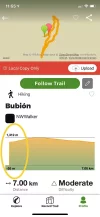
Jeff, thanks for the link to that discussion. Very interesting! Also, your comment about needing 4 satellites to get a 3-D fix explains why our track in the photo below (in the yellow circle) has us starting at 55 meters below sea level and ascending straight up more than a thousand meters! We were in the depths of the Poqueria Gorge and our GPS must have been "hidden" to satellites that were not directly overheard. I've been puzzling over that for awhile and am glad to have an answer.Wikiloc.webp
 
Jeff, thanks for the link to that discussion. Very interesting! Also, your comment about needing 4 satellites to get a 3-D fix explains why our track in the photo below (in the yellow circle) has us starting at 55 meters below sea level and ascending straight up more than a thousand meters! We were in the depths of the Poqueria Gorge and our GPS must have been "hidden" to satellites that were not directly overheard. I've been puzzling over that for awhile and am glad to have an answer.View attachment 53329
Rocket man! 🚀
 
...and ship it to Santiago for storage. You pick it up once in Santiago. Service offered by Casa Ivar (we use DHL for transportation).

❓How to ask a question

How to post a new question on the Camino Forum.

Most read last week in this forum

I saw a video with a rather harsh criticism of a small, municipal albergue on one of the less traveled caminos. They paid 9€. I thought: What does it cost a small municipality to renovate and keep...
On my last Camino (2023) I noticed that there were lots of tourists. It reminded me of a couple of quotes that I have read since my first Camino (2015) “A tourist demands, a pilgrim is grateful”...
"A complete guide to the world's greatest pilgrimage"[sic] by Sarah Baxter. In a British newspaper, The Telegraph. A right wing daily that does print interesting articles and essays...
I've been trying to figure out how to use the Gronze app and as a first step I need to translate into English - I searched topics on the Forum, thought I found what I was looking for, and Yay! I...
Day 42 Week 6 460km walked (give or take) Today I had a revelation, an epiphany and a Divine Intervention... all in one day. Today the exreme pain in my soul is dissipating some... healed by the...
I was hoping to do a walk over ninety days so I researched a long stay visa. This walk would have gone through four countries but the majority of the time would have been in France. So I applied...

Featured threads

❓How to ask a question

How to post a new question on the Camino Forum.

Featured threads

Forum Rules

Forum Rules

Camino Updates on YouTube

Camino Conversations

Most downloaded Resources

This site is run by Ivar at

in Santiago de Compostela.
This site participates in the Amazon Affiliate program, designed to provide a means for Ivar to earn fees by linking to Amazon
Official Camino Passport (Credential) | 2024 Camino Guides
Back
Back
Top