• Remove ads on the forum by becoming a donating member. More here.

Search 74,075 Camino Questions

Google Photos and Map View

Jeff Crawley

Veteran Member
Time of past OR future Camino
A "Tourigrino" trip once Covid has passed, so 2023
Just had this brought to my notice. If you store your photos on Google Photos and your phone or camera tags the file with the location of the shot you can now view the photo by clicking on a map. Note this only seems to work on tablets and smartphones and not desktops (but see below)

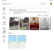
Open Google Photos and click on 🔍 Search

1637764903576.webp

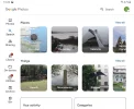
Now click on "Your map"

1637765000110.webp

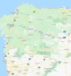
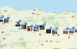
and you get this

1637765049194.webp

those little "heat blobs" are where you took the photos, zoom in and click on an individual spot to jump to the photo.

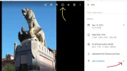
You'll see there appear to be no photos taken between Pontevedra and SdC on my Portuguese Camino. This is because I had "location" switched off on my smart phone. You can add the location retrospectively. On a desktop computer go to Google Photos and double click on the photo you want to tag:
1637765703356.webp

click on the circled i (yellow arrow) and the side panel pops out, click on the pencil (red arrow) to add a location (in this case Astorga). You can click on multiple shots to batch change the location.

Hope this is of interest.
 
Ideal sleeping bag liner whether we want to add a thermal plus to our bag, or if we want to use it alone to sleep in shelters or hostels. Thanks to its mummy shape, it adapts perfectly to our body.

€46,-
You can add the location retrospectively
This is only true if there isn't already a location. If Google has already added a location then it can't be changed, even if it is wrong.

This "feature" is scary for some people because Google can use its massive photo base and AI to infer where the photo is taken.

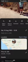
For example, the screen shot below shows a scan of a photo of my Dad taken in the USA on a cheap camera without GPS many years ago.

Without prompting it has located the shot in Arizona. I haven't been there so I don't know if it is correct but it is feasible.
 

Attachments

  • Screenshot_20211125-142718.webp
    Screenshot_20211125-142718.webp
    191.5 KB · Views: 36
Join the Camino cleanup. Logroño to Burgos May 2025 & Astorga to OCebreiro in June
A wonderful memento for you, Doughnut NZ! Thanks to Jeff for the information and steps above.
Also, yes: scary. The only way to be not knowingly part of any of that surveillance is to be - well - even then, finished breathing! Heat detection will still locate us!
 
This is only true if there isn't already a location. If Google has already added a location then it can't be changed, even if it is wrong.

This "feature" is scary for some people because Google can use its massive photo base and AI to infer where the photo is taken.

For example, the screen shot below shows a scan of a photo of my Dad taken in the USA on a cheap camera without GPS many years ago.

Without prompting it has located the shot in Arizona. I haven't been there so I don't know if it is correct but it is feasible.
It certainly isn't infallible! I spent one Christmas in the Atlas mountains in Marocco but Google's AI insists I was a few hundred miles east in Algeria!
 
Similar, this scan is of a photo taken in 1918 after my grandparents wedding and Google was able to situate it, correctly, in West Ham, London, England!
View attachment 113854
The thought process was probably "That looks like Doug in New Zealand's Grandad! Doug's Grandad lived in West Ham. Betcha that photo was taken in West Ham!"

Conversely it does have a tendency to group all photos showing a four legged beasts under "Ranch" including my long departed cat, Tigger :eek:
 
Join the Camino cleanup. Logroño to Burgos May 2025 & Astorga to OCebreiro in June
This is really creepy. I tried to follow your instructions, but as usual, following instructions does not work for me! However, clicking here and there, the result came up with the name of my recently deceased brother, whose photo collage I was using as the test, to see if it would identify where we all had a picnic in 1955 when our baby brother was just that - our new baby brother. Wow!
 
I had no idea Google could do this, regardless of tagging a photos location yourself! I love seeing photos on the map. You can also create a photo album and upload them on a Google map that you create, in an added layer, along with your gps tracks. Your can then see exactly where the photo was taken along the route, with a little circle with the photo in it. Fun, but yes, scary. And people worry about the vaccination microchipping them! Ha ha! Who needs microchips when you have AI?
 
It's going to be a busy (holi)day here in the USA so I will play with this feature sometime later. I do want to add a warning about the creepiness of having GPS data embedded in a jpeg's EXIF information. Not Google related though.

A forum member posted a picture of a place in Pamplona that looked familiar so I looked for the GPS information in the photo. It brought me to a house in a city in California. I got in touch with the member to warn him of this privacy problem. It turned out that, unknown to him, his photo editing software was inserting the GPS coordinates of his home into the EXIF data of the edited image.
 
Ideal sleeping bag liner whether we want to add a thermal plus to our bag, or if we want to use it alone to sleep in shelters or hostels. Thanks to its mummy shape, it adapts perfectly to our body.

€46,-
It's going to be a busy (holi)day here in the USA so I will play with this feature sometime later. I do want to add a warning about the creepiness of having GPS data embedded in a jpeg's EXIF information. Not Google related though.

A forum member posted a picture of a place in Pamplona that looked familiar so I looked for the GPS information in the photo. It brought me to a house in a city in California. I got in touch with the member to warn him of this privacy problem. It turned out that, unknown to him, his photo editing software was inserting the GPS coordinates of his home into the EXIF data of the edited image.
It's not paranoia, they are out to get you! Mind you if you take a look at all of the people you agree to have your information when you click on "agree to all" for cookie settings you'll be appalled - why would a Czech software company be interested in my internet usage? Or one in Poland or the Netherlands?

You can always attempt to go "off grid" by activating Sensors off if you have an Android 10 or later phone.
 
It's going to be a busy (holi)day here in the USA so I will play with this feature sometime later. I do want to add a warning about the creepiness of having GPS data embedded in a jpeg's EXIF information. Not Google related though.

A forum member posted a picture of a place in Pamplona that looked familiar so I looked for the GPS information in the photo. It brought me to a house in a city in California. I got in touch with the member to warn him of this privacy problem. It turned out that, unknown to him, his photo editing software was inserting the GPS coordinates of his home into the EXIF data of the edited image.
so,
 
It's going to be a busy (holi)day here in the USA so I will play with this feature sometime later. I do want to add a warning about the creepiness of having GPS data embedded in a jpeg's EXIF information. Not Google related though.

A forum member posted a picture of a place in Pamplona that looked familiar so I looked for the GPS information in the photo. It brought me to a house in a city in California. I got in touch with the member to warn him of this privacy problem. It turned out that, unknown to him, his photo editing software was inserting the GPS coordinates of his home into the EXIF data of the edited image.
Rick, I will pm you with a couple of photos taken in Pamplona. Let's see what they reveal to your skilled sleuth work!
 
Get a spanish phone number with Airalo. eSim, so no physical SIM card. Easy to use app to add more funds if needed.
Just had this brought to my notice. If you store your photos on Google Photos and your phone or camera tags the file with the location of the shot you can now view the photo by clicking on a map. Note this only seems to work on tablets and smartphones and not desktops (but see below)

Open Google Photos and click on 🔍 Search

View attachment 113839

Now click on "Your map"

View attachment 113840

and you get this

View attachment 113841

those little "heat blobs" are where you took the photos, zoom in and click on an individual spot to jump to the photo.

You'll see there appear to be no photos taken between Pontevedra and SdC on my Portuguese Camino. This is because I had "location" switched off on my smart phone. You can add the location retrospectively. On a desktop computer go to Google Photos and double click on the photo you want to tag:

View attachment 113843

click on the circled i (yellow arrow) and the side panel pops out, click on the pencil (red arrow) to add a location (in this case Astorga). You can click on multiple shots to batch change the location.

Hope this is of interest.
Hi Jeff, thanks for the info. Did you walk Ferro to Santiago? I am planning on going in April. Any on the ground advise? Buen Camino, Elin
 
Rick, I will pm you with a couple of photos taken in Pamplona. Let's see what they reveal to your skilled sleuth work!
I only have time for checking one. Pretty much the only information was the size of photo. You must have used an older camera as the brand of the camera was not even there. Smartphones enter much more data.

I'll say more when I have time.
 
Get a spanish phone number with Airalo. eSim, so no physical SIM card. Easy to use app to add more funds if needed.
I only have time for checking one. Pretty much the only information was the size of photo. You must have used an older camera as the brand of the camera was not even there. Smartphones enter much more data.

I'll say more when I have time.
wow! I used my iPhone, but I sent then to my laptop and then posted them to the pm. I am in no rush, just curious. I know I have not adjusted my iPhone settings at all, so maybe everything turned off. Good!
 
I only have time for checking one. Pretty much the only information was the size of photo. You must have used an older camera as the brand of the camera was not even there. Smartphones enter much more data.

I'll say more when I have time.
Google Photos seems to display a very limited sub-set of the EXIF data. The other image display and editing tools I use can display many more EXIF fields. The big advantage of using Google Photos is the tight integration of the Google product sets. If you are logged in to Google, the Google Maps timeline can show images that are geo-tagged and dated from Google Photos.

I have observed some 'wrinkles', but don't necessarily blame Google. Scanned images will get their EXIF file created by the scanning software, which will date the image with the scan date, not the capture date. So images from photos taken on my film camera can be quite different to when I actually took them. A good EXIF editor will allow the capture date to be added to the EXIF file, but will still retain the date the image is created.

My experience is that there is no geo-tagging done in the scanning software, I have had to do that myself.

If you open an image in Google Photos, there is an info button in the display. Click on that to see the rather limited info Google will let you see from the EXIF file. If a location is set, click on the location information to open the map.

Going from Google Maps, click on the menu button (three short horizontal lines, normally in the top left corner) and then the 'My timeline' selection. It will display where you have been, including a dot for images you have saved that have geo-tags.

I will let you explore how to display the EXIF file in the particular image editing software you might be using. I have several and they all have different approaches to this.
 
Hi Jeff, thanks for the info. Did you walk Ferro to Santiago? I am planning on going in April. Any on the ground advise? Buen Camino, Elin
I did indeed, back in 2018 just after they changed the route and took out the hill at Hospital de Bruma. I also went off the official route to stay at the Casa rural Costa da Egoa - worth it but not everybody would want to go there.
Things will have changed in 40 months - best follow @C clearly's advice below and check out the Ingles section of the forum.
Hope you enjoy it, it's a pleasant little walk - apart from the hill leaving Pontedeume ;)
 
Train for your next Camino on California's Santa Catalina Island March 16-19
If you use an iPhone and the apple Photos app on a MacBook you get a similar map without uploading your pics anywhere. (There may be other combinations that do similar).
The granularity of the map adjusts as you expand it, I mainly use it to find old photos whose date I am unsure.
OTOH my spare phone runs the google Android operating system and can send me a monthly update of all the places I have visited .... I can probably turn some of this off but Android is a "free" operating system and we know what that means.
 

Attachments

  • Screen Shot 2021-11-26 at 10.08.38 am.webp
    Screen Shot 2021-11-26 at 10.08.38 am.webp
    202.5 KB · Views: 17
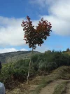
and this is what happens when you start looking at your photos.
Heart tree on the climb up to O Cebreiro.
 

Attachments

  • IMG_7669.webp
    IMG_7669.webp
    401.2 KB · Views: 18
but Android is a "free" operating system and we know what that means.
We sure do, it means that unlike Apple or Microsoft anyone can access the source code for Android and check for themselves what is and is not being done in any area.

This highly desirable feature helps ensure that Android is one of the most secure operating systems available.

Thanks for reminding us of this important point ☺️.
 
Perfect memento/gift in a presentation box. Engraving available, 25 character max.
We sure do, it means that unlike Apple or Microsoft anyone can access the source code for Android and check for themselves what is and is not being done in any area.

This highly desirable feature helps ensure that Android is one of the most secure operating systems available.

Thanks for reminding us of this important point ☺️.
Good points. Very true.
But I was thinking of the adage that if a product is free then, in all likelihood, you are the product and someone else is the customer.
 
I had no idea Google could do this, regardless of tagging a photos location yourself! I love seeing photos on the map. You can also create a photo album and upload them on a Google map that you create, in an added layer, along with your gps tracks. Your can then see exactly where the photo was taken along the route, with a little circle with the photo in it. Fun, but yes, scary. And people worry about the vaccination microchipping them! Ha ha! Who needs microchips when you have AI?
Yap..it's scary and you have an option to turn off the geographic-location if you don't want to..
 
Yap..it's scary and you have an option to turn off the geographic-location if you don't want to..
You can indeed turn off geolocation on your phone but you have missed the point.

The two examples that I gave don't use GPS coordinates from a phone. Both are scans, which don't generally insert GPS coordinates into the metadata, although @Rick of Rick and Peg has an example of a photo editor inserting GPS coordinates.

Both of my examples pre-date GPS with the oldest photo taken in 1918!

What my examples demonstrate is that even without GPS data Google photos can still geolocate a photo using its huge photo base and AI.

There are lots of examples of this around, usually using famous landmarks. What I demonstrated is that Google has enough photo data that they can even accurately geolocate a photo from 1918 taken inside a photographer's studio using a backdrop commonly used by that photographer.

In the case of the more recent photo of my Dad taken on the side of the road somewhere in Arizona it appers that the large cactus that he is standing next to is a common place where others like to stop for a photo and so Google was able to recognize the cactus.

So, even if you turn off geolocation on your phone, Google can in some cases still figure out where you are.
 
Holoholo automatically captures your footpaths, places, photos, and journals.
This is so informative, thanks to all contributors. If I were to take a photo right now using my ipad, would you be able to locate my address? I won't, but what if? Technical stuff is only grasped by me in the doing, not in the theory. That is why it was such a relief when I no longer had to go to programming classes at the beginning of the modern computer, and Apple made it so easy.
 
This is so informative, thanks to all contributors. If I were to take a photo right now using my ipad, would you be able to locate my address? I won't, but what if? Technical stuff is only grasped by me in the doing, not in the theory. That is why it was such a relief when I no longer had to go to programming classes at the beginning of the modern computer, and Apple made it so easy.
Kirkie,
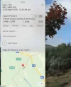
I just went to the original photo of the 'heart tree' pic I posted above and selected get info, this is what is showed me using an Apple Mac. Shows the location and that it was taken back in 2016 with an iPhone 6. However, I do not seem to get this information from the image that I posted above in reply #20.
A quick google on how to do this using a Windows machine says
>> In Windows, all you have to do is right-click a picture file, select “Properties,” and then click the “Details” tab in the properties window. Look for the Latitude and Longitude coordinates under GPS.
>>
 

Attachments

  • Screen Shot 2021-11-26 at 6.34.31 pm.webp
    Screen Shot 2021-11-26 at 6.34.31 pm.webp
    75.9 KB · Views: 21
This is so informative, thanks to all contributors. If I were to take a photo right now using my ipad, would you be able to locate my address? I won't, but what if? Technical stuff is only grasped by me in the doing, not in the theory. That is why it was such a relief when I no longer had to go to programming classes at the beginning of the modern computer, and Apple made it so easy.
If your iPad is wifi only then it does not have a GPS. If your iPad can accept a SIM card then it has a GPS.

If your iPad has a GPS then unless you turn off geolocation it will record your GPS coordinates at the moment that you take a photo.

GPS coordinates are not your address but they can easily be converted into an address.
 
Holoholo automatically captures your footpaths, places, photos, and journals.
Testing, testing, testing! This is what I see when I open the information window on a fabulous (!) photo of the marmalade jar in front of me!!! I did not insert my location. Can you find it? If so, keep it quiet, please! At this stage, I am really curious, but not enough to stop me moving on from here. Have a lovely day, folks!
39ED4DDE-0E8D-403B-83FC-485584027C20.png
Edit. No sim card, so I guess it is safe to post this. Thanks, Doughnut NZ.
 
If you use an iPhone and the apple Photos app on a MacBook you get a similar map without uploading your pics anywhere. (There may be other combinations that do similar).
The granularity of the map adjusts as you expand it, I mainly use it to find old photos whose date I am unsure.
OTOH my spare phone runs the google Android operating system and can send me a monthly update of all the places I have visited .... I can probably turn some of this off but Android is a "free" operating system and we know what that means.
Android is a "free" operating system and we know what that means.

Yep, Google doesn't pay nearly enough in taxes but we get Google Earth . . .
 
3rd Edition. More content, training & pack guides avoid common mistakes, bed bugs etc
If your iPad is wifi only then it does not have a GPS. If your iPad can accept a SIM card then it has a GPS.

If your iPad has a GPS then unless you turn off geolocation it will record your GPS coordinates at the moment that you take a photo.

GPS coordinates are not your address but they can easily be converted into an address.
I find the iPad tech specs confusing on this point. It claims both variants have photo geotagging, but only the Cellular versions have a GPS/GNSS chip. So I assume they are using WiFi or iBeacons to estimate location on the WiFi only models.

This means both WiFi and WiFi + Cellular configurations will geotag images if you don't turn off location services.
 
Good points. Very true.
But I was thinking of the adage that if a product is free then, in all likelihood, you are the product and someone else is the customer.
Sure. But if Apple can sell from you as well as to you, that's twice the income. And there is no reason to expect they are turning down available income.
 
Testing, testing, testing! This is what I see when I open the information window on a fabulous (!) photo of the marmalade jar in front of me!!! I did not insert my location. Can you find it? If so, keep it quiet, please! At this stage, I am really curious, but not enough to stop me moving on from here. Have a lovely day, folks!
View attachment 113908
Edit. No sim card, so I guess it is safe to post this. Thanks, Doughnut NZ.
This appears to be a screen grab of the image, not the image file itself. From what appears on screen, the EXIF file location record in the image file is null. The clue is the text 'Add a location...', indicating the display software could not display anything, and is offering to let you add something.

If you did want to test this, you would need to share the actual image file, not the screen grab.
 
Join the Camino cleanup. Logroño to Burgos May 2025 & Astorga to OCebreiro in June
I could post the original, but really, it is not important as I know where I am! Once again, to all the techs, ¡muchísimas gracias!
 

❓How to ask a question

How to post a new question on the Camino Forum.

Most read last week in this forum

Am busy doing a spring clean/room tidy and having a look at my travel/camino clothes, took photos just for fun...for my next future travels. Missing the long sleeve merino, as am looking at an...
Looking for recommendations. I dislike sleeping bags. I’m also not fond of sleeping bag liners. I own one of each and carried them on all my Camino's but I don't think I ever once slept in them...
Hi there! A few months ago, whilst doing first aid training our instructor mentioned that there were personal, one-use AED defibrillators on the market suitable for carrying in a back-pack. I...
I will be doing the Camino Frances in May/June 2025. I’m trying to decide between Hoka Challengers and Merrill Accentors. The Challengers don’t seem to have a very robust sole as the middle part...
Hallo, First of all - thanks to all of you in this warm and generous community. Every time I have had a question, I've found a thread where someone else asked the same question years ago and it...
While shopping this morning I noticed that Aldi's ski clothing special buys will include merino base layers, and zip and roll neck tops. Due in store this Thursday. I bought a merino top from them...

Featured threads

❓How to ask a question

How to post a new question on the Camino Forum.

Featured threads

Forum Rules

Forum Rules

Camino Updates on YouTube

Camino Conversations

Most downloaded Resources

This site is run by Ivar at

in Santiago de Compostela.
This site participates in the Amazon Affiliate program, designed to provide a means for Ivar to earn fees by linking to Amazon
Official Camino Passport (Credential) | 2024 Camino Guides
Back
Back
Top