Just thought I'd mention that Google Earth v5.2 now has a facility for generating an Elevation Profile based on a path that you can either draw yourself or load from an external source.
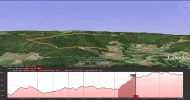
As an example, the image below shows the elevation profile for Betanzos to Bruma on the Camino Ingles. The darker shaded area in the profile is the steep ascent a couple of km before Bruma and selecting it highlights the corresponding part of the path in the main window so you can easily see what terrain it relates to.
This link http://earth.google.com/support/bin/sta ... wer=181393 gives more detail about how to use the facility.
Not everyones ideal to plan to that degree of detail but at least it could help to decide where to stop for that cold beer or energy enhancing Mint Cake before a long climb .
.
Enjoy
Mig
As an example, the image below shows the elevation profile for Betanzos to Bruma on the Camino Ingles. The darker shaded area in the profile is the steep ascent a couple of km before Bruma and selecting it highlights the corresponding part of the path in the main window so you can easily see what terrain it relates to.
This link http://earth.google.com/support/bin/sta ... wer=181393 gives more detail about how to use the facility.
Not everyones ideal to plan to that degree of detail but at least it could help to decide where to stop for that cold beer or energy enhancing Mint Cake before a long climb
Enjoy
Mig


