• ⚠️ Emergency contact in Spain - Dial 112 and AlertCops app. More on this here.
  • Remove ads on the forum by becoming a donating member. More here.

Search 74,075 Camino Questions

Going from Bendueños back to the Camino

Antonius Vaessen

Veteran Member
Time of past OR future Camino
2015-2016 VdlPlata - Sanabres
2016.Primitivo
2017 Salvador
2018 Norte (to Sobrado)
2019 Norte again
If you walk from the albergue in Benduenos to Campomanes there is a shortcut and you also avoid the steep descent to Herias. On the highest point there is path to the left with a signpost Campumanos. The only problem was that there was a stretch of about 150 meters where the trail became very narrow, as a result of high growing plants. This is just before a meadow. Perhaps you can avoid this stretch by walking through the meadow (if possible) When arriving at this point you will see a gate 100-150 meters in front of you. There the path broadens again and very soon afterwards you will get to the Camino path (you will see a yellow arrow right away)
I walked from Benduenos to Mierres, I think it was a little less than 30 km. After leaving Pola de Lena, the marking is confusing, there are arrows pointing to the left and arrows straight on. Straight on is the way to go
 
3rd Edition. More content, training & pack guides avoid common mistakes, bed bugs etc
If you walk from the albergue in Benduenos to Campomanes there is a shortcut and you also avoid the steep descent to Herias. On the highest point there is path to the left with a signpost Campumanos. The only problem was that there was a stretch of about 150 meters where the trail became very narrow, as a result of high growing plants. This is just before a meadow. Perhaps you can avoid this stretch by walking through the meadow (if possible) When arriving at this point you will see a gate 100-150 meters in front of you. There the path broadens again and very soon afterwards you will get to the Camino path (you will see a yellow arrow right away)
I walked from Benduenos to Mierres, I think it was a little less than 30 km. After leaving Pola de Lena, the marking is confusing, there are arrows pointing to the left and arrows straight on. Straight on is the way to go

You know, Antonius, when I left Bendueños in the morning, I had the same thought and saw a sign posting into the forest (I think) toward Campomanes. I knew I wasn't in a rush so I just backtracked. If I ever do a short day into Bendueños, I will work on this! But if you are going to stop at Santa Cristina de Lena, you actually don't need to worry about time or distance because the señora is unlikely to want to come up before 10 am.

Just a few questions -- when you say "on the highest point," what do you mean? Were there other signs? Does this alternative avoid Herias altogether? Wikiloc has a circle route from Bendueños to Campomanes and back, and one of the alternatives avoids Herias, but looks just as long or longer. https://www.wikiloc.com/wikiloc/view.do?id=9618973.

And now the Pola de Lena indicator. Ender re-routed some of the route a couple of years ago to avoid some, but not all of the otherwise harrowing walk alongside an extremely narrow road with a lot of truck traffic going into Ugo. My guess is that you saw signs from both alternatives. Thanks for these updates!
 
With "on the highest point" I mean the point where the road from Benduenos to Herias starts to descend after the climb up from Benduenos. There's a path there to the left. I did not measure this of course but it felt like it was shorter. And we did not have to walk down the steep road.
Regarding the confusing point after leaving Pola de Lena. This was one of the few or perhaps the only time that Enders guide was not so clear. He talks about a gasoline station but we did not see it. So perhaps the left road was the way to go as walking alongside the road indeed was not very pleasant. In other situations Ender gives clear directions. Here I would have expected he had written go left under the "viaduct"? If that was the direction he had in mind.
 
Perfect memento/gift in a presentation box. Engraving available, 25 character max.
With "on the highest point" I mean the point where the road from Benduenos to Herias starts to descend after the climb up from Benduenos. There's a path there to the left. I did not measure this of course but it felt like it was shorter. And we did not have to walk down the steep road.
Regarding the confusing point after leaving Pola de Lena. This was one of the few or perhaps the only time that Enders guide was not so clear. He talks about a gasoline station but we did not see it. So perhaps the left road was the way to go as walking alongside the road indeed was not very pleasant. In other situations Ender gives clear directions. Here I would have expected he had written go left under the "viaduct"? If that was the direction he had in mind.
I'm sure this GPS track is what you mean because I also saw the same turn off:
https://es.wikiloc.com/wikiloc/view...ontent=nearby-trails&utm_campaign=Fri-17Sep01

I descend to Herias and then missed the right turn to the steep path and went to the left on the wide path. Got "lost" and saw a sign for Campomanes but went back to find "official" Camino where I slipped few times because of the rain in previous days. Should have taken one of the two other options which are the same way in the end:
https://es.wikiloc.com/wikiloc/view.do?id=13744579
(you can clearly see where I went wrong which doesn't happen to me very often, hahaha)
 
The first track indeed might be the the way I went, it starts at the point where I left the road. The GPS track farther down is a little bit confusing as it turns back on itself. When I walked ( a month ago) the only problematic stretch was the 150 meters along the fence of the meadow. Then soon I came on the marked Camino.
 
...The GPS track farther down is a little bit confusing as it turns back on itself. When I walked ( a month ago) the only problematic stretch was the 150 meters along the fence of the meadow. Then soon I came on the marked Camino.
Indeed it is confusing because I was confused at the time when there were absolutely no arrows anymore. I also knew that I'm already going in the counter direction so I returned the same way. And this is what you see as a "turn back on itself" :)
 
...and ship it to Santiago for storage. You pick it up once in Santiago. Service offered by Casa Ivar (we use DHL for transportation).
Ok maybe I am not the brightest bulb in the bunch, but I am confused. First question -- what does this mean?
With "on the highest point" I mean the point where the road from Benduenos to Herias starts to descend after the climb up from Benduenos.
.

Are you saying that after Bendueños, we have to ascend before going down to Herías? I remember it being only an ascent from Herías and then a straight down descent back but maybe i'm forgetting a hill in the middle.

Second question is for kinky. I see that the second link goes to your tracks. Are you saying that the first link is what people should do to avoid going back into Herias on their way to Campomanes? Is that the track Antonius took?
 
Ok maybe I am not the brightest bulb in the bunch, but I am confused. First question -- what does this mean?


Are you saying that after Bendueños, we have to ascend before going down to Herías? I remember it being only an ascent from Herías and then a straight down descent back but maybe i'm forgetting a hill in the middle.

Second question is for kinky. I see that the second link goes to your tracks. Are you saying that the first link is what people should do to avoid going back into Herias on their way to Campomanes? Is that the track Antonius took?
I think it's a typo, Laurie. Surely the road from Benduenos to this turn off for Campomanes @Antonius Vaessen took is almost flat (OK, with slight ascent) and then the tarmac road goes down to the right.

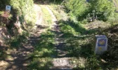
Yes Laurie, the first link is what @Antonius Vaessen walked. The second link is my mistake. I clearly saw the arrow at this point but to me it looked more like it is pointing straight further up (yellow arrow on the mojon which should be angled to the right in my opinion) the wider path than down to the right on the narrower (and official) one to which it was clearly pointing a sign for bicycles. See the picture of that spot:

2016-06-20 10.40.52.webp

On my detour I also saw a marker for Campomanes to the right and there was a path coming from higher up on the left. I'm sure that was also the path @Antonius Vaessen took directly from Benduenos. But can't be 100% sure because I didn't walked it. Just a conclusion on given facts, my memory and maps.

All in all I would say why descend back down to Herias if you stay at Sandra's place in Benduenos. Just take left (marked) turn after the Benduenos before the descend to Herias and you'll be fine.
 
Ok maybe I am not the brightest bulb in the bunch, but I am confused. First question -- what does this mean?


Are you saying that after Bendueños, we have to ascend before going down to Herías? I remember it being only an ascent from Herías and then a straight down descent back but maybe i'm forgetting a hill in the middle.

Second question is for kinky. I see that the second link goes to your tracks. Are you saying that the first link is what people should do to avoid going back into Herias on their way to Campomanes? Is that the track Antonius took?
 
Perfect memento/gift in a presentation box. Engraving available, 25 character max.
In my memory the road from Benduenos to Herias was ascending (perhaps not so steep). Anyway the point that I mean is where the steep descent to Herias begins. The trail goes to the left, to the right there is a broader path.
 

❓How to ask a question

How to post a new question on the Camino Forum.

Featured threads

❓How to ask a question

How to post a new question on the Camino Forum.

Featured threads

Forum Rules

Forum Rules

Camino Updates on YouTube

Camino Conversations

Most downloaded Resources

This site is run by Ivar at

in Santiago de Compostela.
This site participates in the Amazon Affiliate program, designed to provide a means for Ivar to earn fees by linking to Amazon
Official Camino Passport (Credential) | 2024 Camino Guides
Back
Back
Top