Search 74,075 Camino Questions

Getting the metro at Porto airport to head toward Labruge?

LynneR

Active Member
Time of past OR future Camino
CF '16, '18
I'm arriving in Porto tomorrow and plan to make my way up to Labruge for the night. I'd like to take a metro to a place that is convenient and then walk to Labruge. I don't know if there will be signs (arrows or shells) to point me toward the path. Is there anyone who has done this before? I'll be alone and my first time in Portugal, so I'm a bit nervous.
Thanks so much!
Lynne
 
...and ship it to Santiago for storage. You pick it up once in Santiago. Service offered by Casa Ivar (we use DHL for transportation).
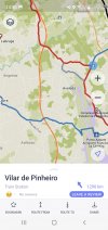
Google shows that from the Porto airport you could bus or subway to Vilhar Pinhero and then walk for 4.2 km.

If you have reserved a place in Labruge you might ask via email how they suggest you travel from the airport.

Good luck and Bom caminho!
 
Last edited:
Join the Camino cleanup. Logroño to Burgos May 2025 & Astorga to OCebreiro in June
Just wondering- since I’ve never been in this country- Would you feel safe alone in a Uber?
Yes. I've been in the Porto area for a couple of weeks now with a broken arm, and have taken many Uber rides. The drivers have all been very good. I haven't taken an Uber solo, but my daughter was here helping me out, and I had no concerns about the several times that she took an Uber alone.
 
Ideal pocket guides for during & after your Camino. Each weighs only 1.4 oz (40g)!
Yes. I've been in the Porto area for a couple of weeks now with a broken arm, and have taken many Uber rides. The drivers have all been very good. I haven't taken an Uber solo, but my daughter was here helping me out, and I had no concerns about the several times that she took an Uber alone.
Thank you! And I’m sorry to hear about your injury.
 
There doesn't seem to be metro route to Labruge

There is but it is a couple of miles short of Labruge. From Porto Airport you take the metro to Verdes (2 stops). Cross over the line (5 steps) and take the northbound metro in the direction of Póvoa de Varzim. Get off at Modivas Sul (4 stops). You can then walk or taxi to the coast (2.7km)

Perhaps your accommodation can suggest how to get from Modivas Sul.

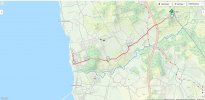
See Metro map.


And a walking route if you are inclined.
 

Attachments

  • Modivas Sul.jpg
    Modivas Sul.jpg
    170 KB · Views: 36
Last edited:
Holoholo automatically captures your footpaths, places, photos, and journals.
I'm arriving in Porto tomorrow and plan to make my way up to Labruge for the night. I'd like to take a metro to a place that is convenient and then walk to Labruge. I don't know if there will be signs (arrows or shells) to point me toward the path. Is there anyone who has done this before? I'll be alone and my first time in Portugal, so I'm a bit nervous.
Thanks so much!
Lynne
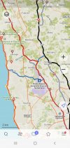
Depends what time you land etc. Its about 9km to Labruge from the airport and I have walked past it but not directly from airport on way there. Have u offline map of the trail?? You can see from the map the way passes very close to airport but its about 2 hrs walk to Labruge so until u find the arrows maybe get a taxi to actual route before beginning to walk. For example my second screenshot shows u a train station u can get taxi to which is beside the coastal route( red line) Its fairly simple and waymarked all the way. The orange line hugging the coast is the Littoral and has few arrows. Daniel
 

Attachments

  • Screenshot_20220609-145105_MAPSME.jpg
    Screenshot_20220609-145105_MAPSME.jpg
    1.3 MB · Views: 21
  • Screenshot_20220609-145636_MAPSME.jpg
    Screenshot_20220609-145636_MAPSME.jpg
    807.4 KB · Views: 29
Depends what time you land etc. Its about 9km to Labruge from the airport and I have walked past it but not directly from airport on way there. Have u offline map of the trail?? You can see from the map the way passes very close to airport but its about 2 hrs walk to Labruge so until u find the arrows maybe get a taxi to actual route before beginning to walk. For example my second screenshot shows u a train station u can get taxi to which is beside the coastal route( red line) Its fairly simple and waymarked all the way. The orange line hugging the coast is the Littoral and has few arrows. Daniel
I'm arriving in Porto tomorrow and plan to make my way up to Labruge for the night. I'd like to take a metro to a place that is convenient and then walk to Labruge. I don't know if there will be signs (arrows or shells) to point me toward the path. Is there anyone who has done this before? I'll be alone and my first time in Portugal, so I'm a bit nervous.
Thanks so much!
Lynne
P.s Labruge is a town between the Littoral and the Coastal so its fairly easy to get to whichever route you take, Coastal or Littoral. However the red line on map(Coastal) passes very close to the airport.
 
A selection of Camino Jewellery
there is a tram that goes to Matsinhos which is about halfway to Labruge
 
We arrive around 6pm into Porto airport on June 20th and plan to take a taxi to near Labruge. It's only around 10km so cannot be that expensive. We are hoping to stay in the Orbiter campsite near there. They won't take a booking at the pilgrim reduced rate but said we are likely to get a bed. We will ring from the airport. If we don't get a bed then we will ring around for private accommodation. Please let us know how you got on LynneR and if you found the route easily.
 
Last edited:
We arrive around 6pm into Porto airport on June 20th and plan to take a taxi to near Labruge. It's only around 10km so cannot be that expensive. We are hoping to stay in the Orbiter campsite near there. They won't take a booking at the pilgrim reduced rate but said we are likely to get a bed. We will ring from the airport. If we don't get a bed then we will ring around for private accommodation. Please let us know how you got on LynneR and if you found the route easily.
 
...and ship it to Santiago for storage. You pick it up once in Santiago. Service offered by Casa Ivar (we use DHL for transportation).
We arrive around 6pm into Porto airport on June 20th and plan to take a taxi to near Labruge. It's only around 10km so cannot be that expensive. We are hoping to stay in the Orbiter campsite near there. They won't take a booking at the pilgrim reduced rate but said we are likely to get a bed. We will ring from the airport. If we don't get a bed then we will ring around for private accommodation. Please let us know how you got on LynneR and if you found the route easily.
I have been at the ORBITUR campsite and sent them an email in advance
I got a confirmed answer back.
There used to work a forum member at the campsite , Rainer from Germany but haven’t seen him for a while here.
These loges at the campsite are very nice and there is a restaurant for diner
Breakfast we gad in a bakershop in the village nearby the campsite
 
We arrive around 6pm into Porto airport on June 20th and plan to take a taxi to near Labruge. It's only around 10km so cannot be that expensive. We are hoping to stay in the Orbiter campsite near there. They won't take a booking at the pilgrim reduced rate but said we are likely to get a bed. We will ring from the airport. If we don't get a bed then we will ring around for private accommodation. Please let us know how you got on LynneR and if you found the route easily.
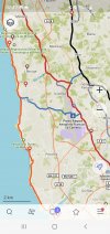
Hi. If you walk direct from airport to Orbiter campsite its should be only 6kms so a taxi will be cheaper. The blue line on below image brings you to the coast. Its one of the official camino crossover points. Unfortunately I cannot seem to send you to link to that app for the actual map so its only a screenshot. Where the blue line reaches the coast is only about 500mtrs from the Campsite. Daniel
 

Attachments

  • Screenshot_20220610-074921_MAPSME.jpg
    Screenshot_20220610-074921_MAPSME.jpg
    1.2 MB · Views: 18
Hi. If you walk direct from airport to Orbiter campsite its should be only 6kms so a taxi will be cheaper. The blue line on below image brings you to the coast. Its one of the official camino crossover points. Unfortunately I cannot seem to send you to link to that app for the actual map so its only a screenshot. Where the blue line reaches the coast is only about 500mtrs from the Campsite. Daniel
Great. Might just walk it so. Will be nice to walk after flights. Unfortunately they won't take a booking but will take our chances.
 
The focus is on reducing the risk of failure through being well prepared. 2nd ed.
We arrive around 6pm into Porto airport on June 20th and plan to take a taxi to near Labruge. It's only around 10km so cannot be that expensive. We are hoping to stay in the Orbiter campsite near there. They won't take a booking at the pilgrim reduced rate but said we are likely to get a bed. We will ring from the airport. If we don't get a bed then we will ring around for private accommodation. Please let us know how you got on LynneR and if you found the route easily.
Hi. If you walk direct from airport to Orbiter campsite its should be only 6kms so a taxi will be cheaper. The blue line on below image brings you to the coast. Its one of the official camino crossover points. Unfortunately I cannot seem to send you to link to that app for the actual map so its only a screenshot. Where the blue line reaches the coast is only about 500mtrs from the Campsite. Daniel
Great. Might just walk it so. Will be nice to walk after flights. Unfortunately they won't take a booking but will take our chances.
Hello again. If u have or use maps.me you can then open that link and download all camino routes throughout Europe or just Portugal if you prefer. Its very handy for certain situations like your plan to get to the campsite. https://www.santiago.nl/downloads/#spanje
 
Hi. If you walk direct from airport to Orbiter campsite its should be only 6kms so a taxi will be cheaper. The blue line on below image brings you to the coast. Its one of the official camino crossover points. Unfortunately I cannot seem to send you to link to that app for the actual map so its only a screenshot. Where the blue line reaches the coast is only about 500mtrs from the Campsite. Daniel
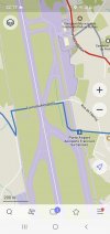
Does the blue line cross the runway of the airport ?
 
Last edited by a moderator:
Holoholo automatically captures your footpaths, places, photos, and journals.
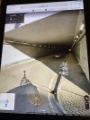
The blue line goes under it through a tunnel road
Indeed it looks like a tunnel . Never have seen this mor heard of it
it is in the rua da Fábrica
The blue line goes under it through a tunnel road
i found this on a website of the municipality of Maia from 2020

The connection, which essentially serves the populations of Vila Nova da Telha, Perafita and Lavra, in the municipalities of Maia and Matosinhos, underwent requalification and expansion works and reopens this Friday, at 6 pm, reports Jornal de Notícias.

The Tunnel under Francisco Sá Carneiro Airport reopens now with another 150 meters in length.

“It is an important link for the local population who, for more than a year during the work, had to go around the airport on their daily journeys. A call that used to take five minutes became 15 or 30 minutes, depending on traffic”, explained to JN Joaquim Azevedo, president of the Vila Nova da Telha Parish Council.

The Maia City Council emphasizes that, with this tunnel, the reopening of the continuation of Rua da Fábrica through the Airport Tunnel and its alignment with Avenida Gago Coutinho, which allows the restoration of access to Vilar do Senhor.

The municipality adds that the renovated airport tunnel has a sidewalk, which allows pedestrians to pass.

It should be noted that the intervention is part of a project to improve the airport's terrestrial communications, budgeted at 15 million euros.
 

Attachments

  • 602BDE77-258A-408A-8616-E720EEA6148F.jpeg
    602BDE77-258A-408A-8616-E720EEA6148F.jpeg
    79.4 KB · Views: 6
Indeed it looks like a tunnel . Never have seen this mor heard of it
it is in the rua da Fábrica

i found this on a website of the municipality of Maia from 2020

The connection, which essentially serves the populations of Vila Nova da Telha, Perafita and Lavra, in the municipalities of Maia and Matosinhos, underwent requalification and expansion works and reopens this Friday, at 6 pm, reports Jornal de Notícias.

The Tunnel under Francisco Sá Carneiro Airport reopens now with another 150 meters in length.

“It is an important link for the local population who, for more than a year during the work, had to go around the airport on their daily journeys. A call that used to take five minutes became 15 or 30 minutes, depending on traffic”, explained to JN Joaquim Azevedo, president of the Vila Nova da Telha Parish Council.

The Maia City Council emphasizes that, with this tunnel, the reopening of the continuation of Rua da Fábrica through the Airport Tunnel and its alignment with Avenida Gago Coutinho, which allows the restoration of access to Vilar do Senhor.

The municipality adds that the renovated airport tunnel has a sidewalk, which allows pedestrians to pass.

It should be noted that the intervention is part of a project to improve the airport's terrestrial communications, budgeted at 15 million euros.
look at Google Maps in Streetview. Rua da Fábrica Maia
 

Attachments

  • 2F64FF51-1E98-4015-97A8-3912C4ECDBB7.jpeg
    2F64FF51-1E98-4015-97A8-3912C4ECDBB7.jpeg
    3.2 MB · Views: 3
  • B56B32FC-2894-4990-A611-1F85ED5575BB.jpeg
    B56B32FC-2894-4990-A611-1F85ED5575BB.jpeg
    1.7 MB · Views: 4
Ideal pocket guides for during & after your Camino. Each weighs only 1.4 oz (40g)!
look at Google Maps in Streetview. Rua da Fábrica Maia
Yes I actually have the route on maps.me and you can walk it all the way without getting lost. I'm a believer in following the arrows so only open the app when I have to, and trying to get out of the airport is such a time. As you see on the screenshot below. Anyhow I will be doing San Salvador from Leon in August and intend turning my phone off completely. Daniel
 

Attachments

  • Screenshot_20220611-221707_MAPSME.jpg
    Screenshot_20220611-221707_MAPSME.jpg
    527.7 KB · Views: 5
Yes I actually have the route on maps.me and you can walk it all the way without getting lost. I'm a believer in following the arrows so only open the app when I have to, and trying to get out of the airport is such a time. As you see on the screenshot below. Anyhow I will be doing San Salvador from Leon in August and intend turning my phone off completely. Daniel
I was planning on not taking my phone on this Camino too........but I'll definitely need it now to get out of the airport. I love the idea of being able to walk from the airport to the Camino. Hopefully I will use no wheels at all now until I return to the airport after Santiago.
 
I was planning on not taking my phone on this Camino too........but I'll definitely need it now to get out of the airport. I love the idea of being able to walk from the airport to the Camino. Hopefully I will use no wheels at all now until I return to the airport after Santiago.
Well enjoy your Camino and safe travels.
 
The focus is on reducing the risk of failure through being well prepared. 2nd ed.
Yes I actually have the route on maps.me and you can walk it all the way without getting lost. I'm a believer in following the arrows so only open the app when I have to, and trying to get out of the airport is such a time. As you see on the screenshot below. Anyhow I will be doing San Salvador from Leon in August and intend turning my phone off completely. Daniel
If you look on Google Maps streetview and enlarge it you will see it is a stage with some roundabouts ,going round corners etc to get in Angeiras where the Orbitur ( not Orbiter ‼️) campingsite is The tunnelroute is a good alternative to get from the airport to the coast so thanks you brought this up. But maybe you need your app sometimes not to get lost.
 
Last edited by a moderator:

❓How to ask a question

How to post a new question on the Camino Forum.

Featured threads

❓How to ask a question

How to post a new question on the Camino Forum.

Featured threads

Forum Rules

Forum Rules

Camino Updates on YouTube

Camino Conversations

Most downloaded Resources

This site is run by Ivar at

in Santiago de Compostela.
This site participates in the Amazon Affiliate program, designed to provide a means for Ivar to earn fees by linking to Amazon
Official Camino Passport (Credential) | 2024 Camino Guides
Back
Back
Top