CykaUJ
Kenyan Heart, Russian Soul, Global Citizen
- Time of past OR future Camino
- Porto to Santiago to Muxia Feb 2016
This is a special kind of insanity on the home stretch for Camino Portugues pilgrims!
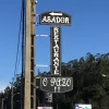
Leaving Padron, there's a temporary diversion about 2,5km out of Padron that takes you up through some narrow residential streets. Then you find yourself at a roundabout with no waymarks (I was finding in a lot of places it was easier to look for the blue arrows to Fatima!), cross over it in the direction of the restaurant O Pazo.


Then was the really crazy final stretch, if someone else has posted about this, I apologise, but I didn't see any other threads and Brierley's doesn't explain it very well.
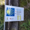
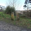
After the marker where it says 6.028 (or something like that), there are no more mileage plates on the fairly new looking marker stones, and they take you through winding neighbourhoods up and down several steep hills, both in forested areas and asphalted. There is something mentioned in the book about a new option to go through A Choupana, but with the other winding hills, it's much more than the .7 that the book says. In fact, from that 6km mark, my runkeeper app came up with 7,9km from where the last marker with plate was that said 6. This A Choupana route is marked with this...

I was really tired by then, pulled out the camino map app I have and it indicated that the actual camino was the left route. It was entirely uphill and went through a housing block. There were very few way marks or arrows painted and I found the whole thing really confusing, so just followed signposts for the Cathedral.
I hope they'll put the mileage plates on soon!
Leaving Padron, there's a temporary diversion about 2,5km out of Padron that takes you up through some narrow residential streets. Then you find yourself at a roundabout with no waymarks (I was finding in a lot of places it was easier to look for the blue arrows to Fatima!), cross over it in the direction of the restaurant O Pazo.


Then was the really crazy final stretch, if someone else has posted about this, I apologise, but I didn't see any other threads and Brierley's doesn't explain it very well.
After the marker where it says 6.028 (or something like that), there are no more mileage plates on the fairly new looking marker stones, and they take you through winding neighbourhoods up and down several steep hills, both in forested areas and asphalted. There is something mentioned in the book about a new option to go through A Choupana, but with the other winding hills, it's much more than the .7 that the book says. In fact, from that 6km mark, my runkeeper app came up with 7,9km from where the last marker with plate was that said 6. This A Choupana route is marked with this...

I was really tired by then, pulled out the camino map app I have and it indicated that the actual camino was the left route. It was entirely uphill and went through a housing block. There were very few way marks or arrows painted and I found the whole thing really confusing, so just followed signposts for the Cathedral.
I hope they'll put the mileage plates on soon!


