Search 74,075 Camino Questions

Distance between Boo de Piélagos and Santillana del Mar?

trecile

Moderator
Staff member
Time of past OR future Camino
Various routes 2016 - 2024
What's the distance between these two places when you take the short train ride at Boo? I'm on the alternate coastal route from Santander, and I'm trying to work out if it's too far (for me) to walk to Santillana del Mar tomorrow.

When I was on the Norte before I was with a Camino "purist" who insisted on skipping the train and walking the long way, so I don't have a concept of what this distance is like.
 
A selection of Camino Jewellery
What's the distance between these two places when you take the short train ride at Boo? I'm on the alternate coastal route from Santander, and I'm trying to work out if it's too far (for me) to walk to Santillana del Mar tomorrow.

When I was on the Norte before I was with a Camino "purist" who insisted on skipping the train and walking the long way, so I don't have a concept of what this distance is like.
Hola Trecile,
It looks as though the distance from Boo via the FEVE and Mogro is about 23kms. Information taken from calculating Terry's loop at 29 kms less the 7kms given as 'the loop' and also from a report here on 'following the arrows'. Hope that helps.
Buen Camino
 
Join the Camino cleanup. Logroño to Burgos May 2025 & Astorga to OCebreiro in June
Trecile
I avoided the ugly pipeline .Exiting Mogro station you walk to the main road ,then cross the road ,turn right and then first left on to a road which climbs slightly.You will pass a church on your left hand side and to the right you will see the Camino arrows.I ignored the right turn and continued straight ahead along the road.I had no problem following the road.I saw faded yellow arrows on the road and it struck me that this may have been the original way.There was little traffic on the road and I would have no hesitation going this way again.Having walked by the ugly pipeline several times before I was so relieved to have avoided it.
 
Being an aficionado (like me) of mapy cz, you can easily measure it with that. From the train station in Mogro, there are 2 possible routes. The one that heads off to the left initially, which I followed, is 22.2 k to the main plaza in Santillana del Mar. Mapy.cz indicates that as the main route. The "ruta alternativa" goes off to the right and passes by Mogro itself, and is 21.9 k from the train station. Both involve roughly the same amount of (relatively negligible) climbing. As I recall, the marking on the ground wasn't that clear, but mapy cz will get you through.

Btw, if you don't care about walking e. f. i and the distance winds up being too much to walk in one day from wherever you are to Santillana, you could always stay on the train a further stop (or 2) and gps your way back to the Camino. It will be obvious with mapy. cz.
 
Last edited:
We walked this this March (2023) and measured it as 21.8 by my GPS watch with 315 meters of climbing. As I recall it was a relatively easy walk even after the big day from Santander to Boo via the coast.
 
Ideal sleeping bag liner whether we want to add a thermal plus to our bag, or if we want to use it alone to sleep in shelters or hostels. Thanks to its mummy shape, it adapts perfectly to our body.

€46,-
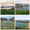
I'm in Santillana del Mar now and my Wikiloc track says 18.12 km from the station at Mogro. I took the advice of @Dave on another thread and walked the old Camino route which saved some kms. My total distance from my starting point in Liencres was about 27.5 km, about the same as yesterday's walk on the coast from Santander, but it took me a couple of hours less as yesterday's trail was very rocky and I didn't stop as often to take pictures. If you go the coast route do take into account that there are many places where you will want to spend time taking in the view, so it will likely make your day longer.
 
I'm in Santillana del Mar now and my Wikiloc track says 18.12 km from the station at Mogro. I took the advice of @Dave on another thread and walked the old Camino route which saved some kms. My total distance from my starting point in Liencres was about 27.5 km, about the same as yesterday's walk on the coast from Santander, but it took me a couple of hours less as yesterday's trail was very rocky and I didn't stop as often to take pictures. If you go the coast route do take into account that there are many places where you will want to spend time taking in the view, so it will likely make your day longer.
Hi were did you start your walk in santander. I like to walk the coastel route in september but i am afraid that it is a little much for my first day. I think if starting at the lighthouse or so .
Also were did you stay in Liencres was it easy to find accmedations?
 
Get a spanish phone number with Airalo. eSim, so no physical SIM card. Easy to use app to add more funds if needed.
When I did this I walked from the lighthouse to Liencres where I ran out of energy. My fitness app recorded 22 km. The lighthouse seemed like a convenient place to start. It’s a beautiful walk, that gets even better after Soto. I did not stay in Liencres but there is a least one hotel there that I saw. And a Posada closer to the coast. Search Liencres, Spain in google maps
 
I'm in Santillana del Mar now and my Wikiloc track says 18.12 km from the station at Mogro. I took the advice of @Dave on another thread and walked the old Camino route which saved some kms. My total distance from my starting point in Liencres was about 27.5 km, about the same as yesterday's walk on the coast from Santander, but it took me a couple of hours less as yesterday's trail was very rocky and I didn't stop as often to take pictures. If you go the coast route do take into account that there are many places where you will want to spend time taking in the view, so it will likely make your day longer.
Could you post a link to @Dave's post, so others can know about that alternative?
 
Hi were did you start your walk in santander. I like to walk the coastel route in september but i am afraid that it is a little much for my first day. I think if starting at the lighthouse or so .
Also were did you stay in Liencres was it easy to find accmedations?
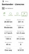
I started from the ferry port. If I were to do it again I would try to stay close to the lighthouse to save some kms on the walk. I tracked my walk with Wikiloc and these are my stats for the first day to Liencres.

Screenshot_20230603_175659_Wikiloc.jpg

I had wanted to stay in Soto de la Marina because that's where others who posted in this thread stayed, but I only booked the day before and other than a 88€ hotel everything was booked, or required a two night minimum. That's why I ended up in Liencres. Now looking back I'm glad that I did get farther because it kept the walk to Santillana del Mar shorter. The hotel I stayed at was Calas de Liencres which was 54€. I thought that wasn't bad for a last minute booking for a Saturday night.


Could you post a link to @Dave's post, so others can know about that alternative?

Here it is.

It's looking like you're just ~7.5km from Boo, based on the gpx. From there, it's another 21km to Santillana if you take the Boo-Mogro train, or 17km if you take the old route direct through Mar.

The information about the old Camino route is in his book

Screenshot_20230605_062625_Firefox.jpg
 
3rd Edition. More content, training & pack guides avoid common mistakes, bed bugs etc
When I did this I walked from the lighthouse to Liencres where I ran out of energy. My fitness app recorded 22 km. The lighthouse seemed like a convenient place to start. It’s a beautiful walk, that gets even better after Soto. I did not stay in Liencres but there is a least one hotel there that I saw. And a Posada closer to the coast. Search Liencres, Spain in google maps
Thank you
 
Trecile
I avoided the ugly pipeline .Exiting Mogro station you walk to the main road ,then cross the road ,turn right and then first left on to a road which climbs slightly.You will pass a church on your left hand side and to the right you will see the Camino arrows.I ignored the right turn and continued straight ahead along the road.I had no problem following the road.I saw faded yellow arrows on the road and it struck me that this may have been the original way.There was little traffic on the road and I would have no hesitation going this way again.Having walked by the ugly pipeline several times before I was so relieved to have avoided it.
Perfect advice!
 
The 2024 Camino guides will be coming out little by little. Here is a collection of the ones that are out so far.

❓How to ask a question

How to post a new question on the Camino Forum.

Most read last week in this forum

Hello all: Due to life circumstances I find myself on the Del Norte route in November... The first couple of weeks (started Oct 14) I fell in with cohorts of pilgrims and everything was good...

Featured threads

❓How to ask a question

How to post a new question on the Camino Forum.

Featured threads

Forum Rules

Forum Rules

Camino Updates on YouTube

Camino Conversations

Most downloaded Resources

This site is run by Ivar at

in Santiago de Compostela.
This site participates in the Amazon Affiliate program, designed to provide a means for Ivar to earn fees by linking to Amazon
Official Camino Passport (Credential) | 2024 Camino Guides
Back
Top