- Time of past OR future Camino
- Madrid/Olvidado/Invierno (2023).
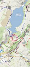
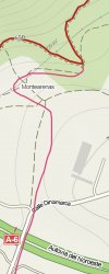
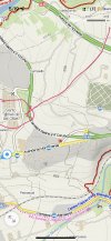
There has been a lot of discussion on this forum about how to get to the 10thC Iglesia de Santo Tomás de Ollas, on the way into Ponferrada. I stumbled on a pretty direct route this morning. You follow the Camino until a kilometre or two before the dam, turning off at a little complex of hydrology offices. From there you can join a marked trail called the Senda de Bas. If you are using Mapy, this route is marked in red on their maps. After the hydrology complex, you will be following a small road, and very soon you will see a marked path crossing the road. Take this to the left. It is an excellent path through a beautiful forest. It’s a really well used and clearly maintained single track in shade with great views over the river. If you were not keen on visiting the church, you could just follow the Senda de Bas all the way into the city. But I’ve put some screenshots below where I have tried to show where I got off the path on to a very direct route that went straight to the church. This happened by accident. I had been going to go much further south, but at some point I looked at my phone and realized I could just turn left!
This first map shows the general area where you leave the Camino. The second is the part through the offices. The third is where I left the marked trail and joined a track. And the fourth shows how it makes its way to the church.


This first map shows the general area where you leave the Camino. The second is the part through the offices. The third is where I left the marked trail and joined a track. And the fourth shows how it makes its way to the church.


