• ⚠️ Emergency contact in Spain - Dial 112 and AlertCops app. More on this here.
  • Remove ads on the forum by becoming a donating member. More here.

Search 74,075 Camino Questions

Chartres or Orleans

CTreacy

Oh no , not again.
Time of past OR future Camino
Portuguese ( Sep 2017)
Primitivo ( Sep 2018)
Norte (Aug / Sep 2019)
del Plata ( Mar / Apr 2020 ?)
Looking at the GR655 map I see it splits after Paris and joins together at Tours. Has anyone done both the Chartres and Orleans variation and recommends one or the other ? More pleasant walking / scenery is my preference. Or if you have done either and loved it, that is good too.
 
The 2024 Camino guides will be coming out little by little. Here is a collection of the ones that are out so far.
Chartres and Orleans
The closest I can come is having taken the train from Paris to Chartres, which made a nice day trip. And I assume the walking route is a little different from the railway. The scenery was very gently rolling, no differently from the rest of that northern plain, with scattered patches of woods. Chartres itself was a fairly small town; the downtown area had been renovated and the streets were wide. From the rail station, on the edge of town, uphill to the cathedral was maybe a 20-min walk that seemed to traverse most of town. Although it was Sunday when I visited, one or two eateries were open. Everything else was closed up, of course. Pleasant enough, but not in the "charming village" category. The cathedral is the main attraction. This is now a bedroom community for Parisian workers.

No experience whatsoever with Orleans, so I can't help you there. Bon route!
 
GR655O (Ouest) - Can't comment about landscapes. Chartres with its cathedral is a highlight.
GR655E (Est) - After Orleans you're in the beautiful Loire valley. The chateau at Blois is spectacular.
 
3rd Edition. More content, training & pack guides avoid common mistakes, bed bugs etc
This sounds like a wonderful dilemma!
I've been to both cities and it would be impossible for me to chose one over the other! Soooo, I just may do as @JabbaPapa suggests... when I'm allowed into France, and feel comfortable enough to get on a plane!
Headed to my map store right now to get both maps! Thanks so much for this @CTreacy !
Oops, maybe I should call first...;)
 
In the 2004 Holy Year we walked to Orleans and stayed in a stunning youth hostel there. We were following a 1998 CSJ Paris to the Pyrenees Guide but the Youth Hostel manager told us that it would be much more scenic and pleasant to follow the river than walking on the road. We took his advice and end up walking the whole day next to the river, without seeing another soul, no villages or shops to buy snacks or drinks - we would've passed 4 villages the other way. In the late afternoon we arrived at a locked gate and had to climb over it and walk through someone's garden to get to the road in front. We had overshot the road to Beaugency so had to double back to get to our reserved accommodation. We stayed in Blois the next night and the B&B owner insisted that a much quicker way to our next overnight stay was along the river. We walked 40km all the way to Amboise! After that we stuck with the Guide book but listened to locals who suggested 'petites' roads that shadowed the main roads between villages.

29 Orleans Youth Hostel.webp34 Amboise Chatteau.webp
 
The 2024 Camino guides will be coming out little by little. Here is a collection of the ones that are out so far.
In the 2004 Holy Year we walked to Orleans and stayed in a stunning youth hostel there. We were following a 1998 CSJ Paris to the Pyrenees Guide but the Youth Hostel manager told us that it would be much more scenic and pleasant to follow the river than walking on the road. We took his advice and end up walking the whole day next to the river, without seeing another soul, no villages or shops to buy snacks or drinks - we would've passed 4 villages the other way. In the late afternoon we arrived at a locked gate and had to climb over it and walk through someone's garden to get to the road in front. We had overshot the road to Beaugency so had to double back to get to our reserved accommodation. We stayed in Blois the next night and the B&B owner insisted that a much quicker way to our next overnight stay was along the river. We walked 40km all the way to Amboise! After that we stuck with the Guide book but listened to locals who suggested 'petites' roads that shadowed the main roads between villages.

View attachment 99152View attachment 99153
Yes -- that's how you do it !!

I only walked a very short stretch of the Loire into, then out of Tours on my 1994 -- but somehow on a completely different non-Camino occasion, I walked a longer stretch (think it was a hitch-hike that went "wrong"), and it's gorgeous -- not excluding the simple little roadside bar lunch I found that day.

So lovely that IIRC, I simply abandoned the hitch-hiking, and just walked a 30 or 40K on that lovely warm late Spring day to a town with a railway station, and got the night train.

One of my best hitch-hikes gone "wrong" ever !! :cool: (absolute best ever was hitching out of Santiago on my 1994, except the first two people to pick me up were the Director of the Cathedral's pilgrims' bureau ; then a Camino employee driving on the Camino to check that all was proper along the route, and so then I found myself at O Cebreiro -- oh well, hitch-hike back to Paris certainly, but clearly someone was telling me : follow the Way back too !!)
 
Looking at the GR655 map I see it splits after Paris and joins together at Tours. Has anyone done both the Chartres and Orleans variation and recommends one or the other ? More pleasant walking / scenery is my preference. Or if you have done either and loved it, that is good too.
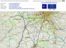
Thanks for all the information provided. I think the Chartres route is the one to take. I have looked at a stage list for the GR655 from Paris. When I input the stage ends /way points and just use Google Maps to calculate the direct distance I get quite a difference in the total length. Does the given stage list look reasonable or is there a better one ( I really don't like 40k days ). I suppose the Google directions could be alongside busy roads or it is possible the the GR route itself is not always the best for every stage. Any views would be gratefully received

1620232950739.webp
 
We took the train to Orleáns and walked from there, using local footpaths to go from chateau to chateau, rather than following the long distance marked trail, until we got to Tours. Instead of heading directly south, detoured to visit Villandry, and Azay-le-Rideau. And then we got back on track. I love a side excursion!
 
3rd Edition. More content, training & pack guides avoid common mistakes, bed bugs etc
Although no firm list exists of what will be we all hope for the possibility of pandemic free walking in 2021/2022

Do keep in mind that here in France there has been in recent years a Chain of Local (donativo) Hospitality for passing pilgrims. Those who offer such hospitality do so for the pleasure of meeting/greeting pilgrims as well as helping them find their way .

See more in French here
 
Thanks for all the information provided. I think the Chartres route is the one to take. I have looked at a stage list for the GR655 from Paris. When I input the stage ends /way points and just use Google Maps to calculate the direct distance I get quite a difference in the total length. Does the given stage list look reasonable or is there a better one ( I really don't like 40k days ). I suppose the Google directions could be alongside busy roads or it is possible the the GR route itself is not always the best for every stage. Any views would be gratefully received

View attachment 99460
You can see some of the reasons for the discrepancies in GR distances and Google Map routes on this blog:


For example, for the stage from Hanches to Chartres, GR655 is almost twice the distance of the direct route because it follows the rivers Drouette and Voise. I guess that the locals (or google street view) can give you some indication of how much more scenic that is. And only you can decide whether a more scenic route justifies walking twice as far.

I sometimes felt frustrated by the pointless diversions from the direct route when I was walking the Via Francigena in the north of France. Sometimes I found that the route was indirect for no good reason. I don't know whether that is the case in this case.

If you wanted to stick to the GR but avoid walking a 40km day, I expect you could break it up.
 
€2,-/day will present your project to thousands of visitors each day. All interested in the Camino de Santiago.
For example, for the stage from Hanches to Chartres, GR655 is almost twice the distance of the direct route because it follows the rivers Drouette and Voise. I guess that the locals (or google street view) can give you some indication of how much more scenic that is. And only you can decide whether a more scenic route justifies walking twice as far.

I sometimes felt frustrated by the pointless diversions from the direct route when I was walking the Via Francigena in the north of France. Sometimes I found that the route was indirect for no good reason. I don't know whether that is the case in this case.
It both is and it isn't -- the waymarked routes into Chartres (the ones from Paris and Rouen especially) do sometimes take what seem like unnecessary detours, for the underlying reason that the French Hiking Federation requires that officially recognised hiking routes must do everything possible to avoid tarmac stretches, or at least avoid main roads in favour of small country ones.

OTOH that particular route along the rivers is most likely to be the historic one, leading through the villages that the mediaeval pilgrims would have sought rather than avoided as many GR paths do.

And then again, in that area of France, there is a multitude of small country roads that one could use as alternative routes.

I've found it best when walking in France to do a bit of a juggling act with the scenic options, the direct routes, and the historic ones -- though I do tend to privilege the direct routes more than the others (and valleys more than mountain crests).

But doing so can sometimes be a huge mistake, as for example on the stretch between Salon-de-Provence and Arles on the Provençal Way, as the direct route is perfectly horrid, whereas the lengthier detour combines the historic route with the villages and one of the most scenic sections of the entire route.

So, choosing the direct way can lead to bad decisions, just as following some overly zealous "hiking not pilgrimage" waymarks can, and the only way really to start to get a "feel" for the better route to follow on any given day is through one's own trial and error.

But well, if you're one of the sportier "hiker" types of pilgrim, well, maybe those waymarked routes are best, for you !!
 
Looking at the GR655 map I see it splits after Paris and joins together at Tours. Has anyone done both the Chartres and Orleans variation and recommends one or the other ? More pleasant walking / scenery is my preference. Or if you have done either and loved it, that is good too.
@CTreacy, you've already decided to go via Chartres and that's a good decision. I walked from Paris to Orleans and then to Tours several years ago. I loved it. I didn't always follow the GR655 nor the itineraries described in the two major French guidebooks available at the time. I used IGN maps and in particular the Iphigenie app to make my own way.

There are a number of local 'camino' associations who are active in the various areas of France and who provide information and mark trails in their area. Some are even competing with each other. Their websites are usually in French but online translation tools are available. Much has changed and improved over the years, in the wake of the increasing popularity of camino walking.

I see that there are websites managed by Compostelle28 for the Eure & Loir area: http://www.kananas.com/compostelle/itineraires/ . They say that in their area which includes the section from Chartres to Tours, there are two routes with signposts for "Chemins de Compostelle". They are distinguished as follows:
  • THE DIRECT ROUTE: The route for pilgrims and hikers practicing long-distance walking. It is described on their website.
  • THE VAGABOND ROUTE: This is the GR 655 West which winds its way through touristic/scenic sites (information on the Conseil Départemental 28 website).
They have information about accommodation in their area. The daily stages or sections are listed, with detailed maps, GPX files, and descriptive PDF files: http://www.kananas.com/compostelle/itineraires-eureliens/

They advise walkers not to follow the signs for "St Jacques à Vélo" as you will risk getting lost.

They also point out that the area is crossed by several pilgrimage ways: Notre-Dame, Saint Michael, Saint Martin and Saint James.
 
I used IGN maps and in particular the Iphigenie app to make my own way.
I see that IGN (French national geographic institute) has now a website called IGNrando. They also offer a mobile app. Rando is short for randonnée - hike or walk. This looks useful. I had used a slightly different IGN website at the time which was called GeoPortail. I found the interactive online IGN maps to be excellent and easy to use. When you pick the appropriate scale, hiking / walking / pilgrimage trails are clearly marked. Superb! Particularly useful for planning beforehand on a large screen.
 
Last edited:
The 2024 Camino guides will be coming out little by little. Here is a collection of the ones that are out so far.
Yes, we also used an app, with the IGN maps - in our case iPhiGeNie. It was great and allowed us to plan our own way.
 
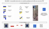
This may be useful: how the "camino" is marked in the Eure & Loir area or department 28, which is the area around Chartres. I've not seen this before but as I said, things have changed/improved in recent years. They use separate marking depending on when the trail to Compostela is not identical with a GR trail and when it overlaps a GR trail. GR trails are always marked with white and red stripes. The shell sign simply means that you are on a Way to Santiago - it does not indicate a direction.

There is no uniform marking of the Ways to Santiago in France. The signs and type of waymarkers may change from one department to the next department.

Balisage.jpg
 
3rd Edition. More content, training & pack guides avoid common mistakes, bed bugs etc
Out of curiosity, I had a look at the last section before Orléans that is currently suggested as a Way to Santiago, and I guess now marked as such.

The current trail is totally different from what was proposed and/or marked years ago! It now goes directly through the forest of Orléans instead of running parallel to the D2020 and parallel to the old aérotrain track that the guidebooks and maps showed in the past.

So, as mentioned, there has been change and improvement over the past years.

A good choice - the current trail follows very roughly the same paths that we walked when we crossed the Orléans forest on our self-made tracks years ago. ☺️
 
Last edited:
Another vote for Iphigenie app on the mobile. I found it immensely helpful; includes all the local routes and roads as well as the GR tracks.
 
You can see some of the reasons for the discrepancies in GR distances and Google Map routes on this blog:


For example, for the stage from Hanches to Chartres, GR655 is almost twice the distance of the direct route because it follows the rivers Drouette and Voise. I guess that the locals (or google street view) can give you some indication of how much more scenic that is. And only you can decide whether a more scenic route justifies walking twice as far.

I sometimes felt frustrated by the pointless diversions from the direct route when I was walking the Via Francigena in the north of France. Sometimes I found that the route was indirect for no good reason. I don't know whether that is the case in this case.

If you wanted to stick to the GR but avoid walking a 40km day, I expect you could break it up.
Indeed my thoughts exactly. I have seen that on other Caminos where you end up almost back where you started for no good reason. Avoiding major roads is a good reason to increase the distance but sometimes the diversions just seem pointless. I do not like 40km days :-)
 
Ideal sleeping bag liner whether we want to add a thermal plus to our bag, or if we want to use it alone to sleep in shelters or hostels. Thanks to its mummy shape, it adapts perfectly to our body.

€46,-
I see that IGN (French national geographic institute) has now a website called IGNrando. They also offer a mobile app. Rando is short for randonnée - hike or walk. This looks useful.
Thanks, this is a great resource, though I'd be unlikely to pay the subscription needed to use it on mobile.

But the web version is cool.

I use mapy.cz , which has the advantage of being both free and available on all platforms, even Windows Phone (though that particular version is rather out of date) !!
 
Last edited:
If you have to choose, Chartres wins hands down -- but it is quite possible to walk to Orléans, including on a stretch of the Loire, from Paris via Chartres.

Soooo .... both, maybe ?
I'm stepping out on the 30th March. Paris to Orléans as I've done Dieppe to Tours another time...
 
I'm stepping out on the 30th March. Paris to Orléans as I've done Dieppe to Tours another time...
Buen Camino !!

Though I would honestly and seriously suggest Paris > Chartres > Orléans.

Tour Saint Jacques > Notre Dame > Sorbonne > Rue de Vaugirard > Porte de Versailles > then bear leftwards in Issy-les-Moulineaux >>> fastest way into some nature from central Paris ; aiming to between Fleury and Clamart.

South through Meudon-la-Forêt and round the airbase > through woodlands to Jouy-en-Josas.

Still suburbs, but you're by now basically in countryside.

South through there through the tamed marshes, and you're into farmland, the last remaining farms inside the Paris suburbs proper.

Carry on through there on a GR, maybe via Villiers-le-Bâcle if you want to or not (that place is pure suburbia, but you might want the R&R), then > Courcelles (on the Tours Way) > Saint-Rémy-lès-Chevreuse > etc. > Chartres. (I'd personally DIY much of that after Saint-Rémy for a less circuitous path.)

Out from Chartres, full DIY South-Easterly towards Les Villages Vovéens or Boisville-la-Saint-Père or whatever > Orléans ; there are multiple potential routes.

Then from Orléans, that glorious walk down the Loire to Tours and then etc. to SJPP and Compostela.

---

Thing is, the walk into Chartres from Paris is among the best walks that there are on this Camino ; and Orléans to Tours on the Loire also, but for different reasons.

I just think, why choose ? Do both !! :cool:
 
...and ship it to Santiago for storage. You pick it up once in Santiago. Service offered by Casa Ivar (we use DHL for transportation).
Buen Camino !!

Though I would honestly and seriously suggest Paris > Chartres > Orléans.

Tour Saint Jacques > Notre Dame > Sorbonne > Rue de Vaugirard > Porte de Versailles > then bear leftwards in Issy-les-Moulineaux >>> fastest way into some nature from central Paris ; aiming to between Fleury and Clamart.

South through Meudon-la-Forêt and round the airbase > through woodlands to Jouy-en-Josas.

Still suburbs, but you're by now basically in countryside.

South through there through the tamed marshes, and you're into farmland, the last remaining farms inside the Paris suburbs proper.

Carry on through there on a GR, maybe via Villiers-le-Bâcle if you want to or not (that place is pure suburbia, but you might want the R&R), then > Courcelles (on the Tours Way) > Saint-Rémy-lès-Chevreuse > etc. > Chartres. (I'd personally DIY much of that after Saint-Rémy for a less circuitous path.)

Out from Chartres, full DIY South-Easterly towards Les Villages Vovéens or Boisville-la-Saint-Père or whatever > Orléans ; there are multiple potential routes.

Then from Orléans, that glorious walk down the Loire to Tours and then etc. to SJPP and Compostela.

---

Thing is, the walk into Chartres from Paris is among the best walks that there are on this Camino ; and Orléans to Tours on the Loire also, but for different reasons.

I just think, why choose ? Do both !! :cool:
Thanks for the advice
 
Buen Camino !!

Though I would honestly and seriously suggest Paris > Chartres > Orléans.

Tour Saint Jacques > Notre Dame > Sorbonne > Rue de Vaugirard > Porte de Versailles > then bear leftwards in Issy-les-Moulineaux >>> fastest way into some nature from central Paris ; aiming to between Fleury and Clamart.

South through Meudon-la-Forêt and round the airbase > through woodlands to Jouy-en-Josas.

Still suburbs, but you're by now basically in countryside.

South through there through the tamed marshes, and you're into farmland, the last remaining farms inside the Paris suburbs proper.

Carry on through there on a GR, maybe via Villiers-le-Bâcle if you want to or not (that place is pure suburbia, but you might want the R&R), then > Courcelles (on the Tours Way) > Saint-Rémy-lès-Chevreuse > etc. > Chartres. (I'd personally DIY much of that after Saint-Rémy for a less circuitous path.)

Out from Chartres, full DIY South-Easterly towards Les Villages Vovéens or Boisville-la-Saint-Père or whatever > Orléans ; there are multiple potential routes.

Then from Orléans, that glorious walk down the Loire to Tours and then etc. to SJPP and Compostela.

---

Thing is, the walk into Chartres from Paris is among the best walks that there are on this Camino ; and Orléans to Tours on the Loire also, but for different reasons.

I just think, why choose ? Do both !! :cool:
I see that there is a place to stay up near Sacre Coeur is it open during the current COVID times? I had problems in Alsace finding places to stay a couple of years ago and ran out of funds too fast...
 
Holoholo automatically captures your footpaths, places, photos, and journals.
I just bookmarked this, for future reference.
Thanks @JabbaPapa !
Cheers -- I'm wondering actually, since this question seems to come up with some frequency, if it's not worth pinning/stickying the thread ?

It's probably the leanest thread of its type I've seen.
 
I see that there is a place to stay up near Sacre Coeur is it open during the current COVID times? I had problems in Alsace finding places to stay a couple of years ago and ran out of funds too fast...
You might email them and ask. Here is their web.

Happy planning. Whenever/wherever you do go Buen camino.
 
You might email them and ask. Here is their web.

Happy planning. Whenever/wherever you do go Buen camino.
Hi, yes I have contacted the Ephrem community and I can stay on the 29th. It was tempting to stay in a Youth Hostel or Backpackers, but there is the possibility some other pilgrims would be at the Ephrem guest house too?
 
Last edited:
A selection of Camino Jewellery

❓How to ask a question

How to post a new question on the Camino Forum.

Featured threads

❓How to ask a question

How to post a new question on the Camino Forum.

Featured threads

Forum Rules

Forum Rules

Camino Updates on YouTube

Camino Conversations

Most downloaded Resources

This site is run by Ivar at

in Santiago de Compostela.
This site participates in the Amazon Affiliate program, designed to provide a means for Ivar to earn fees by linking to Amazon
Official Camino Passport (Credential) | 2024 Camino Guides
Back
Back
Top