• ⚠️ Emergency contact in Spain - Dial 112 and AlertCops app. More on this here.
  • Remove ads on the forum by becoming a donating member. More here.

Search 74,075 Camino Questions

Camino Inglés route

Lizanne801

New Member
Time of past OR future Camino
CF, Finisterre/Muxia, Inglés, Sanabres, Norte 9/23
I’m walking the Camino Inglés this September, Ferrol to SdC, but is it right that you can now get a Compostela after starting from A Coruña, as I’ve just read on gronze.com? Or do you need to have walked 25 km in from your home to start with? Second question: does anyone use the Ferrol bridge?
My travel companions are camino first-timers - and we’re not so young... I think they might like the choice! Many thanks for any advice.
 
The 2024 Camino guides will be coming out little by little. Here is a collection of the ones that are out so far.
If you walk from A Coruña rather than Ferrol then you have to show evidence that you have walked at least 25km in your own country if you want to receive a Compostela.

The footbridge section of the railway bridge from Ferrol to Neda is closed at the moment for repairs. There is no date available for its reopening. So if you want to bypass the estuary inlet you would need to walk the road bridge to Fene instead.
 
A selection of Camino Jewellery
some people do use the N-651 bridge from Ferrol to Fene as a short cut to walking all round the estuary if they are walking as a first stage to Pontedeume. This is because the first stage from Ferrol to Pontedeume round the estuary is long. The N-651 is a dual carriageway road, but there is a fenced in footpath, separate from the traffic. If you do use the bridge, you have still walked 100km from Ferrol, and should still qualify for a compostela, provided you have your two stamps per day.

An alternative is to break the long first stage from Ferrol to Pontedeume up into two and stop overnight at either Xubia or Neda. That is what I would do if I walked the Ingles again. The first stage was too long at 29km or so, and I suffered for it next day.
 
If you decide to walk around the estuary, a stop on Neda will make the stages short. The walk around the Ria Ferrol is lovely, and the albergue in Neda is right on the water.
 
some people do use the N-651 bridge from Ferrol to Fene as a short cut to walking all round the estuary if they are walking as a first stage to Pontedeume. This is because the first stage from Ferrol to Pontedeume round the estuary is long. The N-651 is a dual carriageway road, but there is a fenced in footpath, separate from the traffic. If you do use the bridge, you have still walked 100km from Ferrol, and should still qualify for a compostela, provided you have your two stamps per day.

An alternative is to break the long first stage from Ferrol to Pontedeume up into two and stop overnight at either Xubia or Neda. That is what I would do if I walked the Ingles again. The first stage was too long at 29km or so, and I suffered for it next day.

Having only 5 days to walk to SdC from Ferrol starting a day after arriving from Southeast Asia (Cebu->Hongkong->Madrid-> A Coruña-> bus to town then bus to Ferrol...i dread you, jetlag!) I am now strongly considering crossing directly to Fene via the N-6551. I hope I am not missing much by bypassing Neda. Im torn between fulfilling the full Camino Ingles experience vs. Straining myself too early in the walk. Stupid question: does the view and general experience crossing the N-6551 across the larger expanse of the estuary to Fene have any semblance to crossing to Neda?
Also, difficulty-wise, how does it compare to the Camino Portugues Costal ?
 
€2,-/day will present your project to thousands of visitors each day. All interested in the Camino de Santiago.
I am now strongly considering crossing directly to Fene via the N-6551. I hope I am not missing much by bypassing Neda.
You won't miss much. The walk is through suburbs and along roads most of the way, and markings are a bit confusing. You cross the highway a couple of times on steel pedestrian bridges. The albergue for Neda is actually up in Naron, and not near any restaurants. Neda itself is a nice little town, more banks than it is restaurants. I think you will do fine going across the bridge.:) I have done the route three times staying in the Hotel Kensington on the last one (it is a very nice place right in the town of Naron).
 
If you are able to take the train from La Coruna to Ferrol instead of the bus (depends, of course, on whether the train times are efficient for your arrival), the train will go right round the estuary where the Camino Ingles goes. You will then see what you will miss if you walk across the N-651 bridge from Ferrol to Fene and then on to Pontedeume from then. You will also see what the N-651 bridge cuts out. Taking the train may help you make up your mind.

Also, you need to remember that the N-651 bridge comes up a good hour into the first stage, so you can decide how you feel at that point, what the time is, weather, etc., depending on how you are going.

One other 'trick'. If you have time on your arrival into Ferrol and can walk the 2 km from the start of the Ingles at the harbour until the Ingles leaves the old town, this knocks 2km or 30 minutes off the walk the next day, as you have done it the night before. All you need on the first day is a stamp from Ferrol, and hopefully, you should be able to obtain this from the hotel you stay in.

If you only have 5 days, if you don't take the short cut over the N-651 bridge, you either need to walk the 29km all the way round the estuary from Ferrol on day 1, or stay at either Neda or Xubia on day 1, and then on day 5, walking 40km on the last day from somewhere around Bruma to Santiago. Taking the N-651 bridge knocks about 8km off the first stage, but at, still, over 20km, is still a long walk for some on the first day.

In terms of difficulty on the Ingles, now that the big climb up to Hospital de Bruma has been replaced by an easier, gradual climb, the only difficulty on the Ingles on a 5 day walk is the long stages (20 - 25km plus each, and every, day). There are two 20 - 30 minute climbs out of Pontedeume and Betanzos, on tarmacked roads, but these are at the very start of a day, when hopefully you will be fresher. Another thing to note is that facilities (bars, shops, restaurants, water fountains) don't appear every 3 km or so, and you may well find that these are some 10km apart in some parts. This can catch some people out who are unprepared. The final thing to note is that about half the Ingles is on asphalt, but in the main, you are walking on country roads.

Don't let any of this put you off the Ingles. It is a great walk, especially on the first two days when you walk round the coast, and for those who only have a week, far better, in my opinion, than jumping on the Frances at Sarria. It is a different feeling when you arrive in Santiago having walked a whole Camino. The Ingles is also much quieter, and gives you a genuine pilgrims experience.
 
A selection of Camino Jewellery
something to add to @taga_cenb's question on whether walking across the N-651 bridge will mean that you lose the full Camino experience?

Answer is, absolutely not.

The N-651 bridge is an 8km shortcut, nothing else. You can still obtain a compostela if you go along that route. Yes, I completely agree with @Old_Crow that the full walk round the estuary is lovely, but if the shortcut saves your legs for the future stages, by the time you have reached Pontedeume at the end of the first day, and sat in the square with a beer or glass of wine, or looked over the river at the bridge from Potendeume quayside, you will have completely forgotten about it, or any guilt. You still walk 100km from Ferrol to Santiago.

In addition, there are plenty of other wonderful parts of the Camino Ingles to savour after Fene; walking along the white sand beach at Cabanas, Pontedeume and its bridge, the walk over the railway bridge at Mino, walking along the estuary to Betanzos, the old capital of Betanzos itself, the Eucalyptus forests, Hospital de Bruma, and then to Santiago.

If, when you get there, if your body says, take the N-651 bridge shortcut, do so. But, as @falcon269 rightly says, walk on the left hand side; i.e. the Northern footpath, which means walk under the N-651 at the roundabout and then up the sliproad that side. There are then less junctions on the Fene side to deal with. If you are in luck, the oyster fishermen may be out on their boats just below the bridge when you walk over.
 
This is all exactly what I needed to know, thank you all so much. I’m really looking forward to it.
 
Thank you very much , Peb and Falcon269. Appreciate your vivid descriptions. Will keep all of it in mind.
 
Holoholo automatically captures your footpaths, places, photos, and journals.
One last word before I brush my teeth and go to bed . . .

Beware of the recently uploaded gpx etc. files for "All" of Spain.

In many places, certainly on the CI, these tracks bear no relationship to the rash of granite cairns that have sprouted along the way. For the most part I ended up following the cairns except for my detour to Costa de Egoa. Both start in Ferrol and end in SdC but in between those point they can be quite different.

If I get my tracks downloaded and cleaned up I'll upload some images.

"caveat emptor"
 
Hi Jeff, I too have booked to stay at Costa de Egoa and hope to follow the route on Viewranger. Was it easy enough to find the way?
Thanks Rebecca
 
Hi Rebecca,

In some places it requires some faith - there are no granite markers and, in some places, loads of yellow arrows over the road surface that have nothing to do with the Camino and I didn't see another pilgrim the whole day (though a nice man in a sparkling Mercedes stopped at the top of a hill and asked if I wanted a lift - in my soggy state?)

When you DO see an official sign board (one of the large panels not a cairn) you'll probably let out a sigh of relief too!

Can I ask if you'll be using a GPS unit and whether you're comfortable with kmz/Google Earth at all? Do you know how to "tour" a Google Earth path (effectively flying over it)?

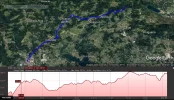
I'm attaching a copy of the section from ViewRanger with the route in green and a second copy in blue which is what I recorded on my Garmin (using OSM mapping) -you'll notice there are differences! You'll see about 7km south of Betanzos I carried straight on down the road instead of turning right. I have no idea why but it was a good choice as took me past a bar (Waypoint BAR 2) and I was soaking wet (the only major rain of the trip).

They are both about 24km long.

The lady at Costa de Egoa (SO sweet) will drop you back on the official Camino the next day after breakfast at the Waypoint "Drop Off". After that you'll come to two cafes (one old one new) "Waypoint Dinosaur" - you'll see! And you're half way to Ordes. Bruma? Where's that?

Sorry if I over/under explained - you could be a world renowned geographer for all I know!

If anything isn't clear or you need a "flying lesson" on GEP let me know.

kind regards

Jeff CBetanzos to Costa de Egoa.webp
 

Attachments

€2,-/day will present your project to thousands of visitors each day. All interested in the Camino de Santiago.
Great map! Would the owner also pick up at the waypoint? That would certainly be easier for someone not so skilled in map reading (like me, for example). I've heard great things about Egoa!
 
Great map! Would the owner also pick up at the waypoint? That would certainly be easier for someone not so skilled in map reading (like me, for example). I've heard great things about Egoa!
I understand she WILL pick up but where from? Will you be walking the Ferrol-SdC or A Coruna-SdC route? She's placed near the join on the west side of the Y where they join.

If you walk from Ferrol you'd turn off at the Presedo refugio and there's no signage until you reach the arm coming down from A Coruna which is about 8km away - you'd need to follow a route on a satnat device at the very least.

I booked through Booking.com - you could make contact and ask (cheat with Google Translate!)

It IS worth it!
 
I understand she WILL pick up but where from?

If it were me, I'd have her pick up and drop off at Bar Avelino, that seems to be the closest spot. Someone else was asking on the Facebook forum about this recently, so I've been thinking about these logistics.

There are such nice casas rurales on this route. I'd love to stay there and Anton Veiras (locals even rave about the food in their restaurant). We stayed at Casa Doña Maria in 2014 and it was marvelous.

Thanks for the great reporting! It shows there are many different ways to make your own Camino!!!

"turn off at the Presedo refugio and there's no signage until you reach the arm coming down from A Coruna which is about 8km away" A question about this statement ... do you mean to say that this part of the route is no longer well marked? In March I followed the path from Coruña and it was exceedingly well marked. The new part from Presedo to where it meets up with the Coruña arm is new as of last summer ... so I had assumed it was probably just as clearly marked. Or do you mean this is the area where you went "off camino" to get to Egoa?
 
Join the Camino cleanup. Logroño to Burgos May 2025 & Astorga to OCebreiro in June
If it were me, I'd have her pick up and drop off at Bar Avelino, that seems to be the closest spot. Someone else was asking on the Facebook forum about this recently, so I've been thinking about these logistics.

There are such nice casas rurales on this route. I'd love to stay there and Anton Veiras (locals even rave about the food in their restaurant). We stayed at Casa Doña Maria in 2014 and it was marvelous.

Thanks for the great reporting! It shows there are many different ways to make your own Camino!!!

"turn off at the Presedo refugio and there's no signage until you reach the arm coming down from A Coruna which is about 8km away" A question about this statement ... do you mean to say that this part of the route is no longer well marked? In March I followed the path from Coruña and it was exceedingly well marked. The new part from Presedo to where it meets up with the Coruña arm is new as of last summer ... so I had assumed it was probably just as clearly marked. Or do you mean this is the area where you went "off camino" to get to Egoa?

I think we're talking at cross purposes. I came down the Ferrol/SdC route and turned off at Presedo refugio and cut across between the two arms of the CI. There is no signage along this route at all, it's the one I picked up from an American pilgrim.

The Bar Avalina is on the other arm of the CI coming down from A Coruna - you can always ask if you can be picked up there!

The attached may make things clearer (or not) ;)
 

Attachments

Thanks for that Jeff. However I'm certainly no Geographer and am not familiar with google earth flying! I had no intention of bringing any GPS device other than what I can access on my phone. I do use Google maps to find my way around Irish backroads but that's about it. Maybe if I get to the Bar you mention I could get them to come and collect me and drop back next day. However if possible I would prefer to walk if i thought I could find my way.
 
The focus is on reducing the risk of failure through being well prepared. 2nd ed.
OK, I see where we are talking about two different things! The map you attached above is very helpful. Where are you are showing the routes joining is the old path, last summer it changed a bit and the route from Ferrol now turns at the church in Leiro (just past Presedo), and joins up with the route from Coruña earlier so both of the arms now walk by Bar Avelino!

I think Rebecca would find it easiest to just follow the marked camino to Bar Avelino and get picked up/dropped off there, if the owners of Egoa are agreeable.
 
Thanks for that Jeff. However I'm certainly no Geographer and am not familiar with google earth flying! I had no intention of bringing any GPS device other than what I can access on my phone. I do use Google maps to find my way around Irish backroads but that's about it. Maybe if I get to the Bar you mention I could get them to come and collect me and drop back next day. However if possible I would prefer to walk if i thought I could find my way.
Morning Rebecca,

If you're not confident using a satnav I wouldn't recommend taking the route I did. It's a lovely route but, given that I had an electronic map in my hand, I still had concerns in places! If the gadget had died on me I might still be wandering the woods - the lost perigrino ingles!

Seriously, make contact with Costa regarding pick up/drop off - their direct website is here: Costa de Egoa and do as @mylifeonvacation says.

Buena suerte!
 
The focus is on reducing the risk of failure through being well prepared. 2nd ed.
Hay,
Ik liep vorig jaar de camino ingles vanuit Ferrol in jun
 
I would vouch for what Faith says. If going off piste to stay at Costa de Egoa, follow the normal Ingles route and be picked up at Bar Avelina, which is now on the Ferrol to SdC Ingles route. If the weather is inclement, or, if you need, you can shelter / eat / drink inside until the pick up arrives. If I recall correctly, Bar Avelina was about an hour away from Hospital de Bruma, meaning that you still need to walk over 20km that day. If this is too far, think about arranging a pick up at the Parroquia de Presedo, which is a lovely place to stop for lunch.

On the markings from Betanzos, the only problem I had that day was that all the guidebooks suggest you cross the main road when you come up out of the village, but the granite waymark sends you left along the main road. There then aren't many granite waymarks (sometimes they are almost 1km apart), so you wonder if you are walking the wrong way), but you keep walking along the road (there is a footpath for most of the way), including down some bends through the woods, for about 4km until you see the turn off on the left hand side, just before you reach Presedo.

I also stayed at Casa Rural Dona Maria. 4 bedroom modrenised house, lovely garden, and best home co
 
Bar Avelina was about an hour away from Hospital de Bruma
Google maps shows it's 2.6km from Bar Avelina to the Albergue en Hospital de Bruma, so however long it takes someone to walk ... at the end of that uphill!
 
Holoholo automatically captures your footpaths, places, photos, and journals.
Reviving an old thread for a quick question (or two):

(a) How many KMs do you cut off the first day if you take the bridge from the Monastary to Neda (not the N-651 bridge)?

(b) If you take the bridge from the Monastary, do you still get a good portion of the estuary walk/views in? that is, do you miss much by not going all the way to Xubia?
 
Reviving an old thread for a quick question (or two):

(a) How many KMs do you cut off the first day if you take the bridge from the Monastary to Neda (not the N-651 bridge)?

(b) If you take the bridge from the Monastary, do you still get a good portion of the estuary walk/views in? that is, do you miss much by not going all the way to Xubia
Point A - I believe 6 km, but I am not certain.

As far as point B is concerned I feel you would miss quite a bit. I actually added in the Variant as well, it's only another kilometer and was really quite nice.
I inadvertently cut across the bridge (Ponte peonil de Xubia I think it's called) directly to the Neda albergue, rather than going all the way into Xubia and back. I apparently missed a half decent cafe in the process.

If for some reason you're concerned about the distance consider making a shorter day of it and stopping in Neda.
Thanks for this - I was debating whether to plan a stop in Neda and I think you have convinced me to take the longer route and do so (Ordinarily I would not be particularly worried about the total distance for the day except that it is the first day and I will probably be a bit jet-lagged and may want to sleep in a bit the first morning.)
 
The focus is on reducing the risk of failure through being well prepared. 2nd ed.
Good call. I wasn't jet lagged and by the time I added in the variants did something like 32 kilometers. It was a long - but beautiful - first day. I've actually commented on other Inglès threads that had time allowed I probably should have done a shorter first day. Luckily, I got away with it.
Incidentally, the Variant leading from the church in Pontedeume is very nice on day two. Or you could do is I did on the evening of day one - walk up the variant, and back down the hill you're going to go up the next morning.....
Amazing how rejuvenated you feel after a 30-minute sleep, a shower and a decent meal!
 

❓How to ask a question

How to post a new question on the Camino Forum.

Most read last week in this forum

Hey I am just trying to put together a Camino for my family (2 adults & 2 kids <10). I am thinking of doing the Camino Ingles in the Easter holidays next year. Currently researching ferry times V...
@Peterexpatkiwi and a few others have mentioned this place on the Ingles, and a know a few folks are planning an Ingles Camino so I though I would share the tip. Just a place with a real buzz and...

Featured threads

❓How to ask a question

How to post a new question on the Camino Forum.

Featured threads

Forum Rules

Forum Rules

Camino Updates on YouTube

Camino Conversations

Most downloaded Resources

This site is run by Ivar at

in Santiago de Compostela.
This site participates in the Amazon Affiliate program, designed to provide a means for Ivar to earn fees by linking to Amazon
Official Camino Passport (Credential) | 2024 Camino Guides
Back
Back
Top