• Remove ads on the forum by becoming a donating member. More here.

Search 74,075 Camino Questions

App for combo Portuguese Camino

Cheryl2445

Member
Time of past OR future Camino
April 2024
I really want to use an app on my Camino, but it seems I have to commit to one route to use one. I’m currently leaning toward taking the Literal out of Porto and then reconnecting to the Central at Vila do Conde. Is there an app you can recommend where I can plot this way? I’m now thinking about just walking the Central out of Porto due to the ease of using one path. It is my first Camino and I have 14 days to get there. That would give me an extra day as well. Help!! lol. I’d love to hear input.
 
...and ship it to Santiago for storage. You pick it up once in Santiago. Service offered by Casa Ivar (we use DHL for transportation).
I didn't have any problems using apps on my Camino Portugues which started on the Senda Litoral and then switched to the Central. Which app is requiring you to stick to one? In another thread, a screenshot was posted from the Wise Pilgrim app (I believe) showing the route to cross over from Vila do Conde on the Senda Litoral/Coastal to Rates on the Central.

How is the app you are using forcing you to remain on one route?
 
The focus is on reducing the risk of failure through being well prepared. 2nd ed.
I just purchased Wise Pilgrim. I think maybe I wasn’t clear at all in my initial post. I’m wanting to pre-map out my route. I’ve already booked all my lodging, and the route was made by studying Bierly and Stingy Nomad. I just want to see my route on an actual (virtual) map of the Camino. I’ve done it on paper, but I want it on my phone. Every app has the routes arranged individually. I can’t find anywhere I can pre-map a route switching from one to another, and I like to plan. Maybe this isn’t possible?
 
I *think* you want your desired route, with the variants you want to take, on a single offline map.

I'd say take a look at Buen Camino, but as you've seen, most of the apps "pre-bake" a single route and its local variants into their map.

The concern with maps.?? and other map only apps is the validity of the route, and the inability to examine the accommodations along the way.

Bom Caminho
 
I just purchased Wise Pilgrim. I think maybe I wasn’t clear at all in my initial post. I’m wanting to pre-map out my route. I’ve already booked all my lodging, and the route was made by studying Bierly and Stingy Nomad. I just want to see my route on an actual (virtual) map of the Camino. I’ve done it on paper, but I want it on my phone. Every app has the routes arranged individually. I can’t find anywhere I can pre-map a route switching from one to another, and I like to plan. Maybe this isn’t possible?
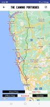
I'm not sure what your question is. As you can see from my screenshot of the Wise Pilgrim map the Central route is green, the Litoral is blue, the Coastal is red, etc.
 
Holoholo automatically captures your footpaths, places, photos, and journals.
I'm not sure what your question is. As you can see from my screenshot of the Wise Pilgrim map the Central route is green, the Litoral is blue, the Coastal is red, etc.
Right! But what I can’t seem to do is plot my accommodators and stops on that map in advance. I’ve done it on Google, but it doesn’t show the official Camino walking paths there. I’m downloading the off-line maps now. Hoping that finally allows me to. Thanks for the help!
 
Right! But what I can’t seem to do is plot my accommodators and stops on that map in advance. I’ve done it on Google, but it doesn’t show the official Camino walking paths there. I’m downloading the off-line maps now. Hoping that finally allows me to. Thanks for the help!
I guess that I wouldn't worry about plotting my overnight stays on the map itself.

You can download tracks to use on Maps.me from this resource:
 
This probably won't work with the camino apps (but I've not used any) but it works in the maps.me app. First use the app to download the base maps of the area where you will be walking.* Then with your downloaded kml files for the various caminos you want to walk you use maps.me to open them.** The app remembers each one you open and displays them all each time you open the app.***

Now comes the nerdy part, you create a text file whose contents are in kml format. It's not difficult if you know the name of your lodging and its longtitude and latitude (in that order, west longtitude is negative). Once done copy the text file to lodgings.kml and use maps.me to open it. Here is a sample file showing two imaginary nearby accommodations right on the camino north of Porto between it and its airport. Edit it to add places of interest:

<?xml version="1.0" encoding="UTF-8"?>
<kml xmlns="http://www.opengis.net/kml/2.2">

<Placemark>
<name>Dew Drop Inn</name>
<description>Night 1</description>
<Point>
<coordinates>-8.6359922,41.2174794</coordinates>
</Point>
</Placemark>

<Placemark>
<name>Notel Motel</name>
<description>Night 2</description>
<Point>
<coordinates>-8.6349156,41.2143590</coordinates>
</Point>
</Placemark>

</kml>


So, when done you have a detailed map of Portugal and Spain with the caminos you want to walk marked in color and pins for lodging along the way that you can click to get the names.

* In the app go to the area you want, for example, Porto, and zoom way in. The app asks if you want to download the map for the area. Of course you do.

** The easiest way for newbies to this is to attach the downloaded kml track to an email to yourself with a good title in the subject line and a good description of the track as the body of the email. Open the email and then the attachment. You will be asked what app you want to open the attachment with. That's maps.me for us.

*** The app will allow you to flag which track (and whatnot) to be viewed or not and also if it should be deleted from its memory (not from the file folders where it resides on your phone). I'm not going into any more detail for that right now.
 
Last edited:
The one from Galicia (the round) and the one from Castilla & Leon. Individually numbered and made by the same people that make the ones you see on your walk.
The creation of a kml file for lodging may seem to be overkill because in the apps that I know you can go to each of the lodging locations and pin them and save them to be displayed each time you have the map showing its area. However, if you decide to change to using a different app you would need to do this all over again there. Also, if you decide to redo the same camino the following year you can hide all the points at once by hiding the kml file instead.
 
A selection of Camino Jewellery
Let me add a tip for anyone adding in latitude and longtitude coordinates in a kml or gpx file. If you are doing so by a cut/copy and paste you may as well do it that way but if you are typing the numbers in you only need four or five decimal places for most areas of the world. I used an online tool to compute the distance between 37.00000,122.00000 and 37.00000,122.00001. The answer was 0.888 meters (fairly close to 3 feet).
 
Doesn’t anybody just go for a walk anymore?

It’s a few years ago now but I left Santander one morning in early spring and walked to Madrid. I knew it was somewhere in the middle and quite high up. Then I walked to Malaga which I knew was on the south coast and after some mountains. Generally going south was easy. Generally going east or west is pretty easy too.
WTF is this obsession with nailing down every step? If you want to go somewhere go there, and enjoy every surprise you encounter on the way
 
A selection of Camino Jewellery
what I can’t seem to do is plot my accommodators and stops on that map in advance
it works in the maps.me app
I used maps.me in this way before they changed ownership a few years ago and made the app more complicated.

I do what the OP wants, very easily, using organicmaps.app. I download the kml files of my route and then add points of interest bookmarks wherever I want. I just find the location and touch the screen to place it, touch the star button, and it is saved. I can edit the bookmark to add any notes, and I can colour-code them. Very easy, and I don't need to know any lat or long coordinates.

Now I have a reference map of my route, available offline, annotated with notes about where there might be muddy patches, locations and contact info for lodging alternatives, etc., etc.

This might be more work than is appropriate for the popular routes where apps are available. However, I am generally walking routes where apps are not available.
 
Thanks so much for asking this question on here! I’m doing a Portuguese combo route too like you are and am narrowing down my route too. I’m thankful you asked and I can piggyback off all the responses you received!
 
I’m wanting to pre-map out my route. I’ve already booked all my lodging, and the route was made by studying Bierly and Stingy Nomad. I just want to see my route on an actual (virtual) map of the Camino.
I've done this using OSMAnd+ on an Android phone, planning the route for the following day. I don't do much more than that because I don't book accommodation more than a day or two in advance, or I am using junta or municipal albergues. The Plan a Route function is in the top level menu of the app and I find it easy enough to use, but I have been doing route planning for walks for some time.

In OSMAnd+, I have walking and cycling tracks enabled, which displays the Camino routes and scallop shell symbol, so it is easy to see where to place the waypoints unless you are using an unmarked route. I have just tried it on the new route leaving Lisbon. OSMAnd+ hasn't included the new route from Sacavem as a Camino route, but the app seems to have picked up the new pathway along the river without any difficulty.

To locate my accommodation, I use the accommodation listing in Gronze, open the map link (this opens in Google maps) and then copy the Plus Code address from there into OSMAnd+. I can then mark that spot, label it and use it in my route planning. There are other ways of share if the Plus Code doesn't work well, which sometimes it doesn't. That tends to be obvious, but it always pays to be careful

There are other good sources of Camino route information that can be used to seed your planning, all available on the internet and discussed here fairly frequently. It shouldn't be too difficult to find them.
 
Last edited:
The 2024 Camino guides will be coming out little by little. Here is a collection of the ones that are out so far.
I just purchased Wise Pilgrim. I think maybe I wasn’t clear at all in my initial post. I’m wanting to pre-map out my route. I’ve already booked all my lodging, and the route was made by studying Bierly and Stingy Nomad. I just want to see my route on an actual (virtual) map of the Camino. I’ve done it on paper, but I want it on my phone. Every app has the routes arranged individually. I can’t find anywhere I can pre-map a route switching from one to another, and I like to plan. Maybe this isn’t possible?
I was recommanded to use this app. : http://alltrails.com/start
 
Get a spanish phone number with Airalo. eSim, so no physical SIM card. Easy to use app to add more funds if needed.
I've used that a bit but now they charge. I never got anymore out of AllTrails than I could with free apps.
I have both Camino Ninja and Wise Pilgrim. I actually spoke to one of the people that has taken Camino Ninja over. It’s been difficult since the developer of that app passed away, but they’re going to work on adding the crossover in the future.

Meanwhile, I just used Brierly’s maps to most accurately figure distances, then I plotted my hotels on a Google map. I’ll use an app once I’m actually walking.. except for my crossover day of course. It’s an easy day anyway.. Just Vila do Conde to Arcos. :)
 
For the Camino I think that a dedicated Camino app is better.
Normally, I would agree. But I haven't seen a dedicated Camino app that provides the planning functionality @Cheryl2445 seems to want. I know this functionality is available in more general purpose mapping apps, like OSMAnd+ which I use, and from what I have seen is available in similar apps, like AllTrails.

Noting that I have used OSMAnd+ and WisePilgrim in combination for my pilgrimages in 2022 and 2023 for daily planning, I can understand why she might want to do that. I know that it wasn't essential for navigation once I was walking. All the routes that I walked were sufficiently well marked that having a moving map was nice to have, but nothing more. Confirming that I had not wandered too far from the route that I was following, or, if I was gong to deviate from a marked route, how far from the route I was getting, was comforting to know.
I think the apps will be great once I’m there and, between Bierly’s book and Google maps, I feel pretty confident in my itinerary now. I have all my lodging booked, and each day looks pretty doable. We shall see though haha.
 
Train for your next Camino on California's Santa Catalina Island March 16-19
Normally, I would agree. But I haven't seen a dedicated Camino app that provides the planning functionality @Cheryl2445 seems to want.
Right, but this was in response to the suggestion of using the AllTrails app. A dedicated Camino app is better (in my opinion) than AllTrails.
 
Right, but this was in response to the suggestion of using the AllTrails app. A dedicated Camino app is better (in my opinion) than AllTrails.
I don't use AllTrails, but presume that is is a general mapping app focussed on track sharing from what I have seen of it. I use OSMAnd+ for route planning and navigation, although I have used WisePilgrim for navigation to see whether that was a better option for me. I can see the attraction for someone who wants to use just one app, and isn't worried about the inherent risks of relying on a single app and information source.

My preference is not to rely on any one source or tool. Sometimes that has a small penalty, such as carrying a guidebook as well as having the WisePilgrim app, Gronze, etc on my smartphone. I will continue to do that.

Much might depend on whether an individual is already familiar with the range of tools available, or has the time or inclination to become competent in their use. I suspect many new pilgrims faced with the myriad tasks they face getting themselves ready will be happy not to add to that list. If they are prepared to rely on simple route planning and navigation tools like Apple and Google maps for their day to day use, learning how to use a general purpose mapping app like Mapy.cz, OSMAnd, etc mightn't be seen as the best use of their time. Using a specialist camino app is a perfectly reasonable approach in those circumstances, and like you, I have recommended that.
 
@dougfitz, I am not a newbie, but have not yet chosen to walk any routes with poor signage, so in preplanning I've only used a guidebook of choice, Gronze, and Google maps. I screenshot pages of the guidebook, and download the maps I need on my phone. I do know there are far better tools available. Possibly if I walked alone I'd be inclined to be more interested in them, but for now they seem unnecessary.
 
Perfect memento/gift in a presentation box. Engraving available, 25 character max.
I think the apps will be great once I’m there and, between Bierly’s book and Google maps, I feel pretty confident in my itinerary now. I have all my lodging booked, and each day looks pretty doable. We shall see though haha.
Hello Pilgrim, I will also be doing the Portuguese in April but starting from Lisbon and while in the past I used Brierly's guide, it does not list the changes out of Lisbon, which makes me wonder what other changes are not included. I do not want to do a Camino glued to my phone, but I do want it to find accommodations along the routes I will be taking. So now I am researching apps, Buen Camino was recommended to me as being current and by reading the various posts here, I would say Maps.me and Gronze seem to be the ones.

Buen Camino🙋‍♀️
Hello there!! I have all of my accommodations pre-booked already. I wanted to know exactly how far I have to walk each day, and also that I have a nice private room waiting. I know that’s not the norm, but that’s a decision I am very happy about. Some places were already booking up, and I know I don’t want to have to deal with looking for a room after I’ve hiked all day. I looked carefully at reviews. I only chose lodging where the reviewers said they’re directly on the Camino. I just wanted to be able to pre-map them out to assure none of my days were too long. It’s so odd that none of the apps are really set up that way. I finally used my Google maps to plot them, and I’ll just follow the markers once I’m there. I do have both Wise Pilgrim and Camino Ninja already downloaded. I’ll get Buen Camino as well! Thanks so much!
 
Buen Camino only disappointed me twice on the Primitivo... once when it did not list the Hotel at Embalse de Salime as a legit stopping point during their "Plan my Stages" function, and a second, more generally, when I was looking for accommodations in a range of destinations. I used Wise Pilgrim ( and once, Gronze) then.

Again, not knowing if Buen Camino lists the Portuguese routes together or separately, I can't say if Plan my Stages will work for you.
 
Perfect memento/gift in a presentation box. Engraving available, 25 character max.
once when it did not list the Hotel at Embalse de Salime as a legit stopping point
We stayed at the awesome hotel at Embalse de Salime with its beautiful deck overlooking the lake and dam, and so glad we did. We'd only stopped in for an afternoon drink on their deck, but decided it was too special to leave and continue on.
 
@dougfitz, I am not a newbie, but have not yet chosen to walk any routes with poor signage, so in preplanning I've only used a guidebook of choice, Gronze, and Google maps. I screenshot pages of the guidebook, and download the maps I need on my phone. I do know there are far better tools available. Possibly if I walked alone I'd be inclined to be more interested in them, but for now they seem unnecessary.
I just like playing with the toys. They are confidence inspiring, but in both Spain and Portugal on my more recent pilgrimages, they have never been essential. As you have observed, the routes, or at least those I have travelled, are well marked.
 
The 2024 Camino guides will be coming out little by little. Here is a collection of the ones that are out so far.
Right, but this was in response to the suggestion of using the AllTrails app. A dedicated Camino app is better (in my opinion) than AllTrails.
I took AllTrails, I believe, on my 2018 Camino Portugues (in addition to the usual Camino-specific apps) and used it for the switchover from the Coastal to the Central at Vila do Conde. At the time, I couldn't find a way to follow that on the maps in the Camino-specific apps, which talked about the switchover but didn't show it, having been set up (apparently) for people walking one route or the other.

Now, it seems, the situation is different and the crossover is better supported in the Camino-specific apps.
 
I used AllTrails when it was free, and liked it, especially the 3D function.

When it asked for money I switched to the free Outdoor Active, which has the same format, great maps, works offline, good hill incline info, lots of user-generated variants, including Camino trails. No 3D unless you pay tho.

It's worth a look.
 

❓How to ask a question

How to post a new question on the Camino Forum.

Most read last week in this forum

I saw a video with a rather harsh criticism of a small, municipal albergue on one of the less traveled caminos. They paid 9€. I thought: What does it cost a small municipality to renovate and keep...
I was hoping to do a walk over ninety days so I researched a long stay visa. This walk would have gone through four countries but the majority of the time would have been in France. So I applied...
"A complete guide to the world's greatest pilgrimage"[sic] by Sarah Baxter. In a British newspaper, The Telegraph. A right wing daily that does print interesting articles and essays...
I've been trying to figure out how to use the Gronze app and as a first step I need to translate into English - I searched topics on the Forum, thought I found what I was looking for, and Yay! I...
My wife and I are planning to buy a house in the north-west of Spain for our retirement. Today, while scrolling through the ads, I noticed this: https://www.idealista.com/inmueble/106560131/...
Hi all - I have often wondered about the whole cutting grams, going as light as .. (I do it too!!) .. thinking about the "real" world with soldiers on the march and what they carry .. Roman...

Featured threads

❓How to ask a question

How to post a new question on the Camino Forum.

Featured threads

Forum Rules

Forum Rules

Camino Updates on YouTube

Camino Conversations

Most downloaded Resources

This site is run by Ivar at

in Santiago de Compostela.
This site participates in the Amazon Affiliate program, designed to provide a means for Ivar to earn fees by linking to Amazon
Official Camino Passport (Credential) | 2024 Camino Guides
Back
Back
Top