Search 74,075 Camino Questions

Advice requested re walking the del Norte

NolaVulling

Member
Time of past OR future Camino
2011,2012,2013,2014,2017,2023
I am planning to walk the del Norte from Irun starting the last week of August. I have the 2015 edition of the Cicerone guide to the Northern Caminos, together with the latest updates. Is there any other info I will need? Would love to communicate with someone who has done this route recently.
 
Ideal sleeping bag liner whether we want to add a thermal plus to our bag, or if we want to use it alone to sleep in shelters or hostels. Thanks to its mummy shape, it adapts perfectly to our body.

€46,-
I finished this route from Irun to Santiago on June 21st. Along with the Cicerone guide I found the phone app editorial Buen Camino to be incredibly helpful as the maps can be used offline. Gronze.com as already mentioned is quite helpful too.

Buen Camino - it's a beautiful route, lots of interesting places to see along the way.
 
Ideal pocket guides for during & after your Camino. Each weighs only 1.4 oz (40g)!
I finished the Norte / Primitivo in May. I found the gronze site very useful for places to stay and planning mileage, although not always accurate. I used maps.me with the downloaded Camino tracks to keep me on the path. I carried the guide but only ever used it a few times for information about towns.
 
I used maps.me with the downloaded Camino tracks to keep me on the path.

How do you do that? I use MapsMe, but how do you put the camino tracks on top, so you know where the camino path is? In simple language, if possible :rolleyes:. I am technologically challenged :oops:. Thanks!
Jill
 
The focus is on reducing the risk of failure through being well prepared. 2nd ed.
In October last year I walked the Norte with the Cicerone guide - and I downloaded the Wise Pilgrim App.

The maps on Wise Pilgrim were handy because if you opened them up when you had wifi (and remembered not to close the App) you could use the map all day while walking and it showed you where you were!!

It's a beautiful way. Buen camino!
 
How do you do that? I use MapsMe, but how do you put the camino tracks on top, so you know where the camino path is? In simple language, if possible :rolleyes:. I am technologically challenged :oops:. Thanks!
Jill
I too am interested in this. I used maps.me on my camino last year (and found it very good) but did not know about including camino tracks...?
 
Train for your next Camino on California's Santa Catalina Island March 16-19
How do you do that? I use MapsMe, but how do you put the camino tracks on top, so you know where the camino path is? In simple language, if possible :rolleyes:. I am technologically challenged :oops:. Thanks!
Jill
I'm at sea at the moment on an iPhone with rare internet access so I have to be brief. If I recall correctly, you can download the tracks from the Cicerone guide site as well as from Wikilocs. Just google "kmz file Camino del Norte". I did this on my PC where I could edit the tracks (changing color and thickness of the gps trail), then e-mailed the kmz (google earth) files to myself and then opened them on the iPhone using maps.me. It will take me 2 weeks before I'm back to land where I can give more detailed instructions.
 
Thank you for all your helpful advice. It is much appreciated. I am a little technically challenged when it comes to using apps but will give it a go.
I'm at sea at the moment on an iPhone with rare internet access so I have to be brief. If I recall correctly, you can download the tracks from the Cicerone guide site as well as from Wikilocs. Just google "kmz file Camino del Norte". I did this on my PC where I could edit the tracks (changing color and thickness of the gps trail), then e-mailed the kmz (google earth) files to myself and then opened them on the iPhone using maps.me. It will take me 2 weeks before I'm back to land where I can give more detailed instructions.
Thank you i look forward to reading your advice.
 
I'm at sea at the moment on an iPhone with rare internet access so I have to be brief. If I recall correctly, you can download the tracks from the Cicerone guide site as well as from Wikilocs. Just google "kmz file Camino del Norte". I did this on my PC where I could edit the tracks (changing color and thickness of the gps trail), then e-mailed the kmz (google earth) files to myself and then opened them on the iPhone using maps.me. It will take me 2 weeks before I'm back to land where I can give more detailed instructions.


I can give you a step by step in a couple of hours, I will just run through it myself and then post it here. :cool:
 
Perfect memento/gift in a presentation box. Engraving available, 25 character max.
These are directions on how to save a Google Maps file (.kmz) on to your phone and take it with you. The request was for the Norte so this is the example I am using.

Let me also preface the directions with this . . . I found a .kmz file (google maps trail) online that looks quite extensive, but I don't know who made this file or how good it is.
These directions will work with any .kmz file


1) Make sure you have the app maps.me downloaded on your phone
2) In the web browser - Safari on your phone go to Google
3) In the google bar type: kmz file Camino del Norte
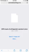
4) The first option should be - El Camino Santiago - Google Earth Maps for the Pilgrimage Road to Santiago (http://www.elcaminosantiago.com/Camino-Santiago-Maps.htm) (See photo attached)
- If you can't find it in google you can just go directly to the website: http://www.elcaminosantiago.com/Camino-Santiago-Maps.htm
5) Choose the option for the Camino del Norte (Approximately 5 down) click on the link
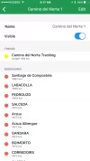
6) You should be given the option to open the file in maps.me (see photos attached)
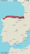
7) When you go in to maps.me you should be able to see the markers on the spanish coast like this picture attached.


While you are still in wifi you may want to download all the Spanish maps along your trail
1) Open Maps.me
2) Move the map until you can see Spain, and zoom into Irun
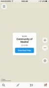
3) As you get closer maps.me show a pop up box saying - "SOME REGION of Spain" Download Map and click on the Download Map
4) Then you move to the next region along your route and Download all the maps to Santiago.


Other maps.me usage tips
1) You can have added tracks (kmz files) saved in your maps.me but turned off, so that your map is cleaner and easier to read
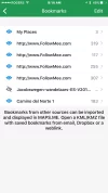
2) Click on the third button on the bottom (Bookmarked locations) and you can turn a book mark on or off by clicking on the arrow and looking at the settings.

Good Luck!

Direct Message me if you have any questions or comments - I will alter the directions if I am missing something.


Image-2.webpImage.webp Image-3.webpImage-1.webpImage-5.webp Image-6.webp
 
These are directions on how to save a Google Maps file (.kmz) on to your phone and take it with you. The request was for the Norte so this is the example I am using.
Direct Message me if you have any questions or comment.

Hi poogeyejr,
Thank you for providing instructions on how to download maps to and use MAPS.me, which I have followed for the Le Puy route. However, I have encountered a glitch that I am unable to resolve and wondered whether you might be able to assist?

I found a Google Maps file at https://www.dustytrack.com/route/ and downloaded it to my Samsung A3 phone but when I zoom into the city of Le Puy the route is represented as a single straight red line across the city - most unhelpful since I need the detailed route to follow to leave the city. (I tried this on other sections of the route with the same result).

At first I assumed it was the smartphone processor trying to resolve the compressed data but as there is no 'refresh' function I can use as on a laptop/computer, I cannot obtain the detailed route.

Do you have any idea as to what the issue might be? ( the processor/the .kmz file/the MAPS.me app).

Many thanks in advance for any help you might be able to offer.
 

@Arbey48

A .kmz file is a collection of points on a map, so the lines you see are "as the crow flies" between the points that the .kmz file has provided your map. If you have lots of long straight lines it is an indication that your .kmz file doesn't have a point every minute or every 5 minutes, but maybe every 15 minutes or 30 minutes (or maybe longer apart).

My recommendation would be to look for a few more .kmz files for this route and once the maps are layered on top of each other you will get more specific detail!

Ask questions - any time!

Kathy
 
A selection of Camino Jewellery
Thank you for your advice.

I also took up the issue with MAPS.me and they are investigating further. Since then though I have been able to download the El Camino Santiago kmz file and this is more viable.

Russell
 
@poogeyejr
Thanks so much for your clear instructions - worked perfectly first time!
Doesn't help me put the kmz file onto my computer, but does get them onto my phone, which ultimately is where I need them. Now to find the files for the Camino de Madrid!
 
@Kiwi-family if you pm me with your email address I can send you the Madrid file for maps.me
 
€2,-/day will present your project to thousands of visitors each day. All interested in the Camino de Santiago.
These are directions on how to save a Google Maps file (.kmz) on to your phone and take it with you. The request was for the Norte so this is the example I am using.

Let me also preface the directions with this . . . I found a .kmz file (google maps trail) online that looks quite extensive, but I don't know who made this file or how good it is.
These directions will work with any .kmz file


1) Make sure you have the app maps.me downloaded on your phone
2) In the web browser - Safari on your phone go to Google
3) In the google bar type: kmz file Camino del Norte
4) The first option should be - El Camino Santiago - Google Earth Maps for the Pilgrimage Road to Santiago (http://www.elcaminosantiago.com/Camino-Santiago-Maps.htm) (See photo attached)
- If you can't find it in google you can just go directly to the website: http://www.elcaminosantiago.com/Camino-Santiago-Maps.htm
5) Choose the option for the Camino del Norte (Approximately 5 down) click on the link
6) You should be given the option to open the file in maps.me (see photos attached)
7) When you go in to maps.me you should be able to see the markers on the spanish coast like this picture attached.


While you are still in wifi you may want to download all the Spanish maps along your trail
1) Open Maps.me
2) Move the map until you can see Spain, and zoom into Irun
3) As you get closer maps.me show a pop up box saying - "SOME REGION of Spain" Download Map and click on the Download Map
4) Then you move to the next region along your route and Download all the maps to Santiago.


Other maps.me usage tips
1) You can have added tracks (kmz files) saved in your maps.me but turned off, so that your map is cleaner and easier to read
2) Click on the third button on the bottom (Bookmarked locations) and you can turn a book mark on or off by clicking on the arrow and looking at the settings.

Good Luck!

Direct Message me if you have any questions or comments - I will alter the directions if I am missing something.


View attachment 34879View attachment 34877 View attachment 34880View attachment 34878View attachment 34881View attachment 34882
Wow, awesome, thank you.
 

❓How to ask a question

How to post a new question on the Camino Forum.

Most read last week in this forum

Planning on walking Norte-Primitivo starting about June 10, 2025. Are the albergues very busy at that time and also what will the weather be? I did this the end of August and September of 2017 and...

Featured threads

❓How to ask a question

How to post a new question on the Camino Forum.

Featured threads

Forum Rules

Forum Rules

Camino Updates on YouTube

Camino Conversations

Most downloaded Resources

This site is run by Ivar at

in Santiago de Compostela.
This site participates in the Amazon Affiliate program, designed to provide a means for Ivar to earn fees by linking to Amazon
Official Camino Passport (Credential) | 2024 Camino Guides
Back
Back
Top