We got most of this this all straightened out on the great Virtual Planning thread. The Lana comes into Santo Domingo de Silos, and from there goes to Covarrubias and on the Mecerreyes. But I do have a question, so bear with me, sorry.
For anyone who wants to take a detour to visit the newly opened (after years of rehab work) Monastery of San Pedro de Arlanza, one way to do it is to walk from Santo Domingo to San Pedro and then to Covarrubias. That turns what would be a walk of 16-17 kms into one of about 26, which makes Covarrubias a nice stopping place for the night. It’s a pretty touristy place, but I have to say it’s very charming.
My question is about the route from Santo Domingo to the Monastery. We learned when we were doing the plannning thread that there is a Desfiladero (gorge), the Desfiladero de la Estacada somewhere along the way. I do not think I want to walk through that gorge, based on what I have read.
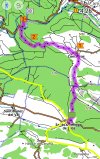
I have seen two different wikiloc tracks for the route from Santo Domingo to San Pedro.
This one goes through the gorge:

 www.wikiloc.com
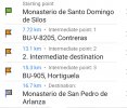
This one takes a slightly different route, going through the town of Contreras.

 www.wikiloc.com
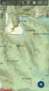
Does anyone with good map-reading skills have an opinion as to whether that second trail is likely to avoid the gorge? I can’t really see where the gorge is. I actually wrote to the author of the second set of tracks and he responded that he didn’t remember any gorge, so maybe I am being overcautious, but since I’ll be alone I would really like to be sure.
Or has anyone walked this way?
For anyone who wants to take a detour to visit the newly opened (after years of rehab work) Monastery of San Pedro de Arlanza, one way to do it is to walk from Santo Domingo to San Pedro and then to Covarrubias. That turns what would be a walk of 16-17 kms into one of about 26, which makes Covarrubias a nice stopping place for the night. It’s a pretty touristy place, but I have to say it’s very charming.
My question is about the route from Santo Domingo to the Monastery. We learned when we were doing the plannning thread that there is a Desfiladero (gorge), the Desfiladero de la Estacada somewhere along the way. I do not think I want to walk through that gorge, based on what I have read.
I have seen two different wikiloc tracks for the route from Santo Domingo to San Pedro.
This one goes through the gorge:

Del 'Monasterio San Pedro de Arlanza' a 'Santo Domingo de Silos' por el 'Desfiladero de la Estacada'
Del 'Monasterio San Pedro de Arlanza' a 'Santo Domingo de Silos' por el 'Desfiladero de la Estacada' Hiking trail in Retuerta, Castilla y León (España). Download its GPS track and follow the route on a map. Record your own itinerary from the Wikiloc app, upload the trail and share it with the...
This one takes a slightly different route, going through the town of Contreras.

San pedro de arlanza - Santo Domingo de Silos. GDM Everest
San pedro de arlanza - Santo Domingo de Silos. GDM Everest Hiking trail in Retuerta, Castilla y León (España). Download its GPS track and follow the itinerary on a map. Travesia desde el GDM Everest desde el monasterio San pedro de arlanza a Santo Domingo de Silos. Pasando por Sad Hill, el...
Does anyone with good map-reading skills have an opinion as to whether that second trail is likely to avoid the gorge? I can’t really see where the gorge is. I actually wrote to the author of the second set of tracks and he responded that he didn’t remember any gorge, so maybe I am being overcautious, but since I’ll be alone I would really like to be sure.
Or has anyone walked this way?


