• ⚠️ Emergency contact in Spain - Dial 112 and AlertCops app. More on this here.
  • Remove ads on the forum by becoming a donating member. More here.

Search 74,075 Camino Questions

Lana detour — Iglesia San Baudelio

peregrina2000

Moderator
Staff member
As I have started poking around my Lana route (hopefully I will start from Alicante in mid May), I see that a church that has been on my wish list for decades is about 35 kms from Retortillo. I think that is the closest that the Lana gets to it. San Baudelio is the church whose early romanesque paintings are housed in the Museo del Prado, and they are the paintings that first introduced me to Romanesque way back when in 1970 when I was taking a History of Spanish Art course that involved a weekly visit to the Prado. I would absolutely love to visit the church itself, even if the artwork will be a reproduction. :-)

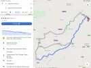
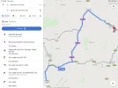
With my super duper Wikiloc premium, I am able to search for trails that pass through two spots, but nothing recorded comes up between Retortillo and San Baudelio, which is located in a little town called Casillas de Berlanga. But strangely, on google maps, if you click the walking option, it shows a 28 km walk, which is clearly off road because the car route is 35 kms. I’ve attached those two pictures.

If any of you have any ideas about this, I’d appreciate it. I suppose I could use google maps to walk, but I have had problems with that on the camino in the past. The hospitalera in the Retortillo albergue has already offered to pick me up and drive me back to Retortillo, so I would only walk one way.

Thanks and buen camino, Laurie
 

Attachments

  • 1926C00E-AC70-4BCB-A79E-E7A4ADCB8C47.webp
    1926C00E-AC70-4BCB-A79E-E7A4ADCB8C47.webp
    138.4 KB · Views: 33
  • 3F01D3C3-6116-446B-9C99-98C8953DBC17.webp
    3F01D3C3-6116-446B-9C99-98C8953DBC17.webp
    122.5 KB · Views: 30
Get a spanish phone number with Airalo. eSim, so no physical SIM card. Easy to use app to add more funds if needed.
I hope you get some feedback on this one Laurie. Your passion for early Romanesque leads you far afield.
I’m amazed at the level of discovery you factor into your trips. For someone who professes to be ‘non tekky’ - you lose me with your wikiloc skill.
Good old maps.me seems more my thing.
Maybe I just need some lessons.

There is always someone out there on this forum who’s been there before but sometimes it’s the waiting until they log in .
Buen camino
Annie
 
I like your challenges Laurie. I think I know how to get a track for you. But I think Google has plotted one along a road but perhaps a one lane dirt track that it doesn't like to put cars on.
 
Get a spanish phone number with Airalo. eSim, so no physical SIM card. Easy to use app to add more funds if needed.
I like your challenges Laurie. I think I know how to get a track for you. But I think Google has plotted one along a road but perhaps a one lane dirt track that it doesn't like to put cars on.

Well, google has placed me and my car on enough dirt roads for me to think that’s not what’s going on, but maybe you are right. Anyway, a dirt track would be just fine! But I am so glad to have piqued the interest of one of our tech gurus.
 
Did you try switching the map layers and following the route on Google maps in satellite view or on Google Earth to see if a dirt track shows up the whole way? We were amazed at the good walking route Google found for us when we had an extra day near the Malaga airport and wanted to walk to the beach - all on a dirt track.
 
On a quick look at Google Earth, it looks a a dirt track the whole way except for a few short intersections with pavement. The next question would be whether it is a private road with a locked gate at some inconvenient spot. Would the hospitalera know?
 
The one from Galicia (the round) and the one from Castilla & Leon. Individually numbered and made by the same people that make the ones you see on your walk.
I've created a track for you Laurie. See an upcoming PM. The last part does look like dirt roads through farming areas with an area of scrub also. I saw a very short section heading from a road up a ridge where no road or trail was marked (at least on the base map I was using). It leads to another road. This must be why Google didn't have the walking trail it created for you as one that could be driven. I ran into this problem once on a trail where instead of being a half mile of trail to my destination it gave a route of about 15 miles. All because a very short section of the trail was not mapped.

Later I'll send more information (publicly) on how to create a kml track from Google maps and how to view it. This stuff is new to me. That's why I like your challenges -- I can learn things.
 
This forum is such a wonderful place, I am so appreciative. I know from the Camino Castellano-Aragonés that there is a lot of gobsmacking romanesque (and earlier) architecture in Soria, and it looks like I am lucky enough to be heading that way again. Buen camino, Laurie
 
Later I'll send more information (publicly) on how to create a kml track from Google maps and how to view it. This stuff is new to me. That's why I like your challenges -- I can learn things.

Rick, I'll be very interested to see how to do this. Thanks!

Laurie, once you get the track that Rick sends you uploaded to wikiloc, you might want to try looking at it with the various map overlays that are available (in Wikiloc). I saw some interesting things in the area when I zoomed in on the IGN map and on the OpenCycle map. At one spot on the OpenCycle map, there is a single track trail shown.
 
€2,-/day will present your project to thousands of visitors each day. All interested in the Camino de Santiago.
It turns out that converting a Google driving/walking directions map to a KML or KMZ GPS file is pretty easy (and those can be converted to a GPX file using other tools). First remember two things: I just learned how to do this today so I'm hardly an expert and also that Google is not great in finding trails although it does okay with back roads. Oh yeah, do this on a PC. Things are too messed up on a phone.

I remembered something from previous internet searches about driving directions and GPX files so I assumed that the conversion could be done. So I Googled
convert google map to kml
and right on top was a link to
https://help.scribblemaps.com/knowl...rt-map-data-from-google-my-maps-to-a-kml-file

That webpage was missing instructions on how to create one of those maps it talks about. So I Googled
create google map
which lead me to:
https://support.google.com/mymaps/answer/3024454?co=GENIE.Platform=Desktop&hl=en

There are a few lines of instructions at the top that you want to read then click the link on the right that says
Save directions on My Maps
which brings you to this page of instructions:
https://support.google.com/mymaps/answer/3502610?hl=en&ref_topic=3024924#

That is pretty much it except you have to have access to a Google account to do this. If your hacking skills are rusty I suggest using your own account for trial purposes.

So, lets try going to https:/mymaps.google.com
Sign into an account (if not already signed-in)
Create a new map
Click "untitled map" and fill in the pop-up
Click the Y looking icon next to the ruler (should show a tool tip of "Add directions")
That brings up your two type-in boxes for start and end points.
I entered Boston and New York.
The track runs through Hartford.
I could save now but these are driving directions and so I switch to walking directions by clicking the car and then the person walking.
The track now passes through Middleton.
Go up to the top where the name of your map is shown.
Left click the three vertical dots.
Chose "Export to KML/KMZ"
Export the entire map (just use the defaults right now)
Download
Pick a folder and name that you like.

That's it. Use this saved file with all the various GPS apps you know about. Experiment with fancier things later.
 
Thanks, Rick. That is very helpful!

I ended up using this site to convert the Google maps walking track to GPX format:

I then uploaded the GPX to my Wikiloc account:

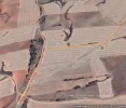
Next, I downloaded that track to Google Earth by clicking on the grey "google Earth" tab on the Wikiloc download page. It automatically appeared when I opened Google Earth, and I was able to zoom in and see whether the track actually follows something that exists on the ground. With a few minor exceptions, it does indeed follow a dirt track. The date of the imagery showing up on my Google Earth screen for that area was 8/24/2019, so pretty recent. However, it goes through a lot of areas with plowed fields, so at one point (see photo below), for a very short distance, it looks plowed up, but there is an alternate track nearby (the diagonal track that completes the triangle).
Screen Shot 2020-01-10 at 12.39.22 PM.webp

I'll leave the wikiloc track on my account for a week or so in case anyone wants to download it. Later, I'll remove it so it doesn't confuse anyone, since it is an untested track.
 
Later I'll send more information (publicly) on how to create a kml track from Google maps and how to view it. This stuff is new to me. That's why I like your challenges -- I can learn things.
I know I for one would love to learn ‘this new stuff’

I never want to stop learning. Edit; your post just came up :: Phew!!! Maybe I’ll start learning later .. a bit beyond me unless I have an assistant nearby. (That’s where the children will come in).
Annie
 
Last edited:
Perfect memento/gift in a presentation box. Engraving available, 25 character max.
You do not need to convert the track to GPX. Wikiloc will convert whatever format was uploaded into the format that the downloader wants. And Google uses or prefers to use the KML/KMZ formats. I believe that it created them.

I'm rarely on a Windows system so I forget about Google Earth. Thanks for the reminder.

I'm going to have to play with that Maps to GPS tool now too. Sigh. So much to do.
 
Maybe I don't understand the issues here but isn't this an easy way: Forget Google Maps; use Google Earth; Get Directions for Retortillo de Soria and Casillas de Berlanga; click to copy the search result to My Places; select the search result in My Places and Save Place as .... You have a kmz file! Upload it to Wikiloc. And while you are at it, of course, you can look at the satellite images in Google Earth to assess the quality of the trail. Or all three of them.

Edited to add: Google Earth Pro 7; MacOS.
 
Last edited:
Train for your next Camino on California's Santa Catalina Island March 16-19
but isn't this an easy way: Use Google Earth; Get Directions for Retortillo de Soria and Casillas de Berlanga;
Edited to add: Google Earth Pro 7; MacOS.
Aha! I never once in the hundreds of times I've used Google Earth noticed the "Get Directions" tab! When I read your directions and went to try it out, I looked all over for that tab and finally spotted it in a very obvious place right below the search bar window. How easy! Thanks.
 
Aha! I never once in the hundreds of times I've used Google Earth noticed the "Get Directions" tab!
I think this may well have been the first time today that I really used it ☺. It also took me a while to find the icon underneath the search result that saves it to MyPlaces. I am familiar with MyPlaces, though, since I entered my whole Camino walk manually into Google Earth ... when I started a long time ago walking to Santiago (in stages), I was too afraid of draining my iPhone battery (I started a really long time ago when batteries didn't last long) so no tracking apps for me. And once you start a tradition, you don't want to give it up. 😇
 
Last edited:
I am familiar with MyPlaces, though, since I entered my whole Camino walk manually into Google Earth ... when I started a long time ago walking to Santiago (in stages),
I bet that makes a nice map to look at! I started saving multiple trails in Google Earth as a planning device before we did our Genal Valley walk, wanting to see where various Wikiloc tracks intersected, but then I switched to Gaia GPS because I found it easier to use for color coding and cropping tracks.
 
Holoholo automatically captures your footpaths, places, photos, and journals.
Maybe I don't understand the issues here but isn't this an easy way:
Okay, if you know what you are doing I suppose. Though I have a friend who worked designing and testing program usability for a big software firm who is never going to see Google Earth and me at the same time if I can help it.
 
Although a lot of this tech discussion went right over my head, I am very happy to now have walking tracks out to the church. I am thinking that I might make it a whole walking circle. Walk from Retortillo to the church and then continue on to Berlanga de Duero. Next day back to Retortillo to continue on. I might have the time to do this, and it would be my preference, so we’ll see how things work out.
 
Although a lot of this tech discussion went right over my head, I am very happy to now have walking tracks out to the church. I am thinking that I might make it a whole walking circle. Walk from Retortillo to the church and then continue on to Berlanga de Duero. Next day back to Retortillo to continue on. I might have the time to do this, and it would be my preference, so we’ll see how things work out.

So excited to hear about your upcoming Lana adventure, Laurie. And I am interested in any alternatives that exist around the official route. Maggie & Co walked another path in the same area after Retortillo de Soria - is this anything you will explore as well? And do you know if you will walk through Sigüenza?

/BP
 
A selection of Camino Jewellery
So excited to hear about your upcoming Lana adventure, Laurie. And I am interested in any alternatives that exist around the official route. Maggie & Co walked another path in the same area after Retortillo de Soria - is this anything you will explore as well? And do you know if you will walk through Sigüenza?

/BP
Hi, BP, Yes, I am definitely hoping to take that alternative from Retortillo. My notes say:

Retortillo to Caracena GR 86 (25). This is day with detour from Retortillo. Leave via archway. At small chapel, camino goes right, GR goes left.

Did you do this alternative? I confess I can't remember, but I have taken many notes from your Lana posts as well! And yes, I will go through Sigüenza, if all goes well. I was there years ago and would like to return to see it again.

No I didn't try Maggies alternative. I know what you mean by the small chapel: I turned right, to continue to Tarancueña.

The 8 kms between Retortillo de Soria and Tarancueña are all road walking, so I can see the need for an alternative. But right after Tarancueña comes the beautiful walk in the mountain gorge - will you miss out on that if you take the alternative? I guess I have to return to Maggies blog to see where the alternativ joins the official route. It would be a shame to miss out on the mountain gorge...!
 
Last edited:
No I didn't try Maggies alternative. I know what you mean by the small chapel: I turned right, to continue to Tarancueña.

The 8 kms between Retortillo de Soria and Tarancueña are all road walking, so I can see the need for an alternative. But right after Tarancueña comes the beautiful walk in the mountain gorge - will you miss out on that if you take the alternative? I guess I have to return to Maggies blog to see where the alternativ joins the official route. It would be a shame to miss out on the mountain gorge...!

Oh well, the alternative joins Tarancueña so you will still walk through the gorge. I will definitely check out the Camino de la Maggie next time I'm in the vicinity!

Buen camino

BP
 
€2,-/day will present your project to thousands of visitors each day. All interested in the Camino de Santiago.

❓How to ask a question

How to post a new question on the Camino Forum.

Featured threads

❓How to ask a question

How to post a new question on the Camino Forum.

Featured threads

Forum Rules

Forum Rules

Camino Updates on YouTube

Camino Conversations

Most downloaded Resources

This site is run by Ivar at

in Santiago de Compostela.
This site participates in the Amazon Affiliate program, designed to provide a means for Ivar to earn fees by linking to Amazon
Official Camino Passport (Credential) | 2024 Camino Guides
Back
Back
Top