• ⚠️ Emergency contact in Spain - Dial 112 and AlertCops app. More on this here.
  • Remove ads on the forum by becoming a donating member. More here.

Search 74,075 Camino Questions

1765 map of camino real in gipuzkoa

caminka

Veteran Member
Time of past OR future Camino
see signature
during my research about via bayona I came upon this thesis - I'm not sure what the actual title is, actually -, but on pages 32 and 33 is a beautiful map drawn in 1765 which shows the entire Camino Real de Coches in gipuzkoa. it shows both the old route via tunél de san adrián and the new route via mondragón and another pass more to the west. almost every town is drawn individually! 🤪

and it also cleared my answers about where did pilgrims cross river bidasoa from france to spain (in a barge or later via a bridge). the crossing is upstream from irun on the spot where the river exits the mountains and before it widens towards the sea. there are two villages named behobie on either side of it, béhobie on the french side and behobia on the spanish side.

plus, it confirms the different course of this postal route in álava, the route that guillaume manier in 1726 and arnold von harff in 1498-99 have taken, via galarreta and audikana.
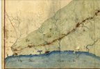
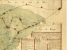
CaminoRealEnGipuzkoa ArchivoCartografico SGE-Ar.F-T.1-C.4-149 1 irun-villafranca 1765.jpg CaminoRealEnGipuzkoa ArchivoCartografico SGE-Ar.F-T.1-C.4-149 2 villafranca-vitoria 1765.jpg
 
Last edited:
€2,-/day will present your project to thousands of visitors each day. All interested in the Camino de Santiago.
caminka,
Those hand drawn 18th c maps look great. Thanks for posting them and detailing what they show. In your research have you checked the varied forum posts which mention Bidasoa?
I have not yet. I am not yet there.

I am actually trying to solve the mystery of arnold von harff's litzauwe (between ernane and billafona), albert jouvin's litsaur (between ornita and iroulo) and guillaume manier's lichart (between andouin and billione). there is no village or town with such name and it drives me a bit up the wall. my guess at the moment is the river leitzaran but since it flows into orio in andosain...
 
Join the Camino cleanup. Logroño to Burgos May 2025 & Astorga to OCebreiro in June
Such beautiful maps @caminka, thanks for sharing them (and also the thesis).

I was delighted to read your comment about the traditional crossing point between France and Spain. I'm doing a short walk on this route in May and had already decided to cross at this point. The 'symmetry' of the place names appealed to me (Urrugne Behobie to Irun Behobia), but it also feels like a more logical route. Nice to know that it has an historical basis.
the thesis has other interesting maps, but is otherwise completely unhelpful basque. 🤨

I have been wondering about this crossing for some time because it didn't seem logical that the route would cross the river where it is very wide and marshy. but for now I only studied those pilgrim diaries that I have (arnold von harff 1498-99, several french itineraries from 16-18C, guillaume manier 1726) and none were anywhere near precise. two travellers' itineraries cleared this crossing for me, albert jouvin de rochefort from 1666-8 and théophile gautier from 1840 who both mention island of the pheasants (isla do los faisanes) being to the right of the barge/bridge when crossing the river. (this was the island where the marriage between louis XIV of france and maria teresa de espana took place in 1659, by proxis if I'm not mistaken.) I have yet to check cassini's map but I suspect it will only confirm this.

coincidentally, I crossed that bridge 11 years ago when I was coming from SJPP on a bit rendered GR-10 (it was a rainy/stormy day and I stayed off the ridges).
 
I have been wondering about this crossing for some time because it didn't seem logical that the route would cross the river where it is very wide and marshy. but for now I only studied those pilgrim diaries that I have (arnold von harff 1498-99, several french itineraries from 16-18C, guillaume manier 1726) and none were anywhere near precise.
Hi @caminka! Your comment reminded me of something. Merely based on memory and without much checking of Google news again: The crossing on foot near the Isla de los Faisanes through the Bidasoa river near Behobia is still used today by young migrants with illegal/not yet clarified status of stay, and sadly, there have been fatal accidents because they are not familiar with the location. Again, merely based on memory: depending on whether the tide (or whatever the exact term is) is in or out, it is quite safe to cross or very dangerous because the strength of the current changes accordingly and perhaps also the depth of the water.

So my guess it that it was quite feasible and reasonable for pilgrims to cross in earlier times, and also perhaps easier in the summer than in other seasons?
 
Last edited:
Get a spanish phone number with Airalo. eSim, so no physical SIM card. Easy to use app to add more funds if needed.
Hi @caminka! Your comment reminded me of something. Merely based on memory and without much checking of Google news again: The crossing on foot near the Isla de los Faisanes through the Bidasoa river near Behobia is still used today by young migrants with illegal/not yet clarified status of stay, and sadly, there have been fatal accidents because they are not familiar with the location. Again, merely based on memory: depending on whether the tide (or whatever the exact term is) is in or out, it is quite safe to cross or very dangerous because the strength of the current changes accordingly and perhaps also the depth of the water.
I would guess that would be near today puente de santiago. the river there is wide and at low tide mostly shallow, as I recall. wooden posts were sticking out of the marshy ground most of the way along the pedestrian lane towards the bridge in the morning. (I read somewhere that these are considered to be the posts where the barge travellers crossed on was tied.) the middle current still had depth, though.
but this part is also right under the police noses, being next to the border crossing. so maybe there is another, better hidden, crossing?
 
I would guess that would be near today puente de santiago.
No, that's not it. The bridge is called Puente Internacional de Behovia. It is the bridge closest to the Isla de los Faisanes and to the east of the island (upstream). The Puente de Santiago is further away and to the west of the island (downstream).
 
No, that's not it. The bridge is called Puente Internacional de Behovia. It is the bridge closest to the Isla de los Faisanes and to the east of the island (upstream). The Puente de Santiago is further away and to the west of the island (downstream).
oh, yes, I see know. I somehow overlooked the island bit.
the river doesn't seem particularly shallow there on google maps (but maybe it is when the tide goes out?). perhaps the draw is the island where one could rest or hide if necessary.
 
Train for your next Camino on California's Santa Catalina Island March 16-19
oh, yes, I see know. I somehow overlooked the island bit. the river doesn't seem particularly shallow there on google maps (but maybe it is when the tide goes out?). perhaps the draw is the island where one could rest or hide if necessary.
It may be worth looking further into this. Have a look at the section Historia y etimología in the Spanish Wikipedia article about the Isla de los Faisanes and also in the French article. These articles are not always accurate but can provide leads. It does say something about this crossing in Roman times and also about a connection to a Saint James hospital I think but perhaps not relevant.

Oh look what I found ☺️: L’Hôpital de Saint Jacques est crée sur la rive droite de la Bidassoa en 1135, quelques mètres en amont de l’actuel pont Saint Jacques. [...] Cet endroit était le passage des pèlerins qui, suivant le Chemin de la Côte, voyageaient à pied, le gué de Béhobie étant le passage des autres pèlerins qui allaient à Compostelle sur des cavaleries ou en charriot.
 
Last edited:
It may be worth looking further into this. Have a look at the section Historia y etimología in the Spanish Wikipedia article about the Isla de los Faisanes and also in the French article. These articles are not always accurate but can provide leads. It does say something about this crossing in Roman times and also about a connection to a Saint James hospital I think but perhaps not relevant.

Oh look what I found ☺️: L’Hôpital de Saint Jacques est crée sur la rive droite de la Bidassoa en 1135, quelques mètres en amont de l’actuel pont Saint Jacques. [...] Cet endroit était le passage des pèlerins qui, suivant le Chemin de la Côte, voyageaient à pied, le gué de Béhobie étant le passage des autres pèlerins qui allaient à Compostelle sur des cavaleries ou en charriot.
That is a very old hospice indeed. Although, this descriprion places the hospice very near to puente de santiago, not puente internacional.

I once came across an article about salmon fishing in the bidasoa river by the priory on the french side of puente de santiago. It had close-ups of some detailed maps of a weir in the river, and one of then featured hopital de st Jacques. But I don't remember the date.
 
...and ship it to Santiago for storage. You pick it up once in Santiago. Service offered by Casa Ivar (we use DHL for transportation).
I am actually trying to solve the mystery of arnold von harff's litzauwe (between ernane and billafona), albert jouvin's litsaur (between ornita and iroulo) and guillaume manier's lichart (between andouin and billione). there is no village or town with such name and it drives me a bit up the wall. my guess at the moment is the river leitzaran but since it flows into orio in andosain...
@caminka, I guess that you have seen that various online sources say that von Harff's Litzauwe refers to a village or place called Leizaur; that Andoain was called Leizaur; and that there was a medieval ferreira or herreria of Leizaur, also called Lizaur, now disappeared without trace, at 43º 12' 42.8" N , 2º 0' 56.9" W which is close to Andoain and lies between Villabona and Irun. Does this not fit with the other travellers' itinerary?
 
Last edited:

❓How to ask a question

How to post a new question on the Camino Forum.

Featured threads

❓How to ask a question

How to post a new question on the Camino Forum.

Featured threads

Forum Rules

Forum Rules

Camino Updates on YouTube

Camino Conversations

Most downloaded Resources

This site is run by Ivar at

in Santiago de Compostela.
This site participates in the Amazon Affiliate program, designed to provide a means for Ivar to earn fees by linking to Amazon
Official Camino Passport (Credential) | 2024 Camino Guides
Back
Back
Top