• ⚠️ Emergency contact in Spain - Dial 112 and AlertCops app. More on this here.
  • Remove ads on the forum by becoming a donating member. More here.

Search 74,075 Camino Questions

Rocamadour: Issigeac via Chateau Bonaguil and Luzech to Rocamadour Sanctuary (13 days, Nov-Dec 2024)

lovingkindness

Veteran Member
Time of past OR future Camino
.
Bonjour tout la monde!

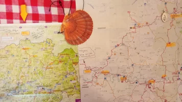
...just before Christmas (2024) I set off along deserted trails for Rocamadour Sanctuary (Dordogne, France). I used old maps that showed roman roads and national trails to wind my way from the medieval village of Issigeac (near Bergerac) via Chateau de Gavaudun and Chateau de Bonaguil down to the River Lot.

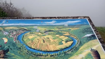
On a map Le Lot looks like a Python digesting several big dinners. The Gaules and Romans liked this stretch of the world very much and established themselves on the limestone cliffs above and in the fertile loops below.

...after following Les Chemin des Crêtes I scrambled down the limestone cliff to Luzech where there is an église Saint-Jacques, a cosy gîte d'étape (kitchenette, hot showers, heating) and three small museums -Luzech was already inhabited in prehistoric times. The museums include casts of dinasaur footprints and gigantic fossilised nautilus shells excavated locally. From there I continued on to Cahor (a stop on Voie du Puy). Rocamadour was a three-day walk along the GR 46 from there.

Trails (13 days): GR 654 Est, GR636, GR 36, GR 46

*Issigeac - Castillonés: local trail then GR 654E

*Castillones via Montaut to Monflanquin: Gr 654E/GR 636

*Monflanquin - Lacapelle-Biron: GR 636

*Lacapelle-Biron - Cahors: GR 36

*Cahors - Rocamadour Sanctuary: GR 46

Useful sites:

www.geoporteil.gouv.fr
Carte topographique IGN

GR-infos is a network of hiking trails in France

11 Stages:
Issigeac - Castillonés

Castillonés via Montaut to Monflanquin

Monflanquin - Paulhiac

Paulhiac via Chateau de Gavaudun to Lacapelle-Biron

Lacapelle-Biron via Chateau Bonaguil to St-Martin- le-Redon

St-Martin-le-Redon - Puy-L'Évêque

PUy-L'Évêque - Luzech

Luzech - Cahors

Cahors - Vers

Vers - Labastide-Murat

Labastide-Murat - Rocamadour Sanctuaire
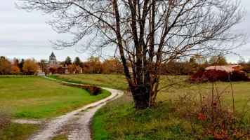
20241119_130719.webp
Day 1 Leaving Issigeac (local trail)...
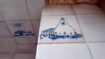
20241122_081602.webp
Day 3 Pauhilac...( gîte de pèlerins coming soon)
20241122_113207.webp
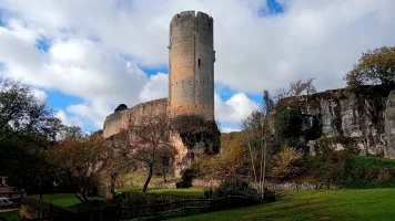
Day 4 Chateau de Gavaudun...

20241122_125955.webp
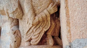
Église Saint-Sardos de Laurenque...

20241123_134216.webp
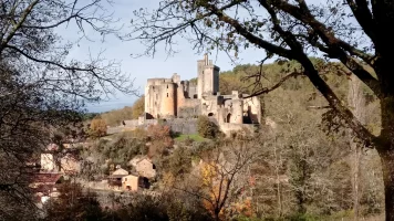
Day 5 Chateau de Bonaguil...

20241123_094657.webp

20241125_155035.webp
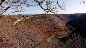
Day 7 scrambling down to Luzech

20241127_121119.webp
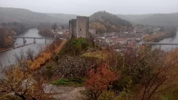
Day 9 ...Le Lot viewed from above Duelle
20241201_112924.webp
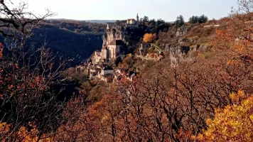
Day 12 ...Rocamadour Sanctuaire
20241201_114141.webp
L'Hôspitalet viewed from afar, where medieval pilgrims sheltered before arriving in Rocamadour.
 
Last edited:
Fail to prepare? reduce your risk by buying this book full of practical info.
2nd ed.
3rd Edition. Vital content training & pack guides avoid common mistakes, bed bugs etc
R.E.S.P.E.C.T!!!

I am in awe, I wish I could do something like this, I'm walking VG and VP in April, but that's about the limit of my adventurousness on a solo basis. I would need to walk with someone who could figure this all out to do something like what you've done. Thanks for sharing, and the pictures too. Wow!
 
Get a spanish phone number with Airalo. eSim, so no physical SIM card. Easy to use app to add more funds if needed.
R.E.S.P.E.C.T!!!

I am in awe, I wish I could do something like this, I'm walking VG and VP in April, but that's about the limit of my adventurousness on a solo basis. I would need to walk with someone who could figure this all out to do something like what you've done. Thanks for sharing, and the pictures too. Wow!
You could at least visit Rocamadour by train like I did. It just takes one full, yet relaxing day. We didn't feel rushed and enjoyed a nice lunch at a restaurant overlooking the valley below. No overnight was needed to mess up the stage, although we had planned two nights in Figeac and were glad we did. This trip was "winged" a day at a time.
 
This route sounds both adventurous and romantic in the sense of invoking days of yore. I'm familiar with the Lot only from the prehistoric paintings in the caves and the vineyards of Bergerac. Only yesterday - being snowed in - I was exploring my copies of the GRs to find an alternate hike from that of Le Puy-en-Velay to SJPP. Did you camp or use local hebergements? I am intrigued to attempt this myself, albeit in warmer months.

A marginally different question/topic: when I was in Paris in November and walked past the Tour St. Jacques, I recalled that this marked one of the traditional starting points for pilgrims setting off to Santiago. (For those aficionados of Harry Potter, the rue Nicolas Flamel ends at the Tour - Flamel's grave marker is in the Musée Cluny.). Have you - or any readers - attempted to walk from Paris to SJPP? Given the extensive network of GRs, it must be feasible.
 
I've visited Rocamadour several times to visit a friend who owned a shop. It is fascinating. The small chapel with the dark statue of Virgin Mary is austere. The local soft cheese is wonderful. I forget the spelling but it sounds like "cabby coo" in English. I remember seeing pilgrims in the town. There are locations where you can see the cave paintings.
 
Ideal sleeping bag liner whether we want to add a thermal plus to our bag, or if we want to use it alone to sleep in shelters or hostels. Thanks to its mummy shape, it adapts perfectly to our body.

€46,-
Bonjour tout la monde!

...just before Christmas (2024) I set off along deserted trails for Rocamadour Sanctuary (Dordogne, France). I used old maps that showed roman roads and national trails to wind my way from the medieval village of Issigeac (near Bergerac) via Chateau de Gavaudun and Chateau de Bonaguil down to the River Lot.

On a map Le Lot looks like a Python digesting several big dinners. The Gaules and Romans liked this stretch of the world very much and established themselves on the limestone cliffs above and in the fertile loops below.

...after following Les Chemin des Crêtes I scrambled down the limestone cliff to Luzech where there is an église Saint-Jacques, a cosy gîte d'étape (kitchenette, hot showers, heating) and three small museums -Luzech was already inhabited in prehistoric times. The museums include casts of dinasaur footprints and gigantic fossilised nautilus shells excavated locally. From there I continued on to Cahor (a stop on Voie du Puy). Rocamadour was a three-day walk along the GR 46 from there.

Trails (13 days): GR 654 Est, GR636, GR 36, GR 46

*Issigeac -Castillonés: local trail then GR 654E

*Castillones via Montaut to Monflanquin: Gr 654E/GR 636

*Monflanquin - Lacapelle-Biron: GR 636

*Lacapelle-Biron - Cahors: GR 36

*Cahors - Rocamadour Sanctuary: GR 46

Useful sites:

www.geoporteil.gouv.fr
Carte topographique IGN

11 Stages:
Issigeac - Castillonés

Castillonés via Montaut -Monflanquin

Monflanquin - Paulhiac

Paulhiac via Chateau de Gavaudun to Lacapelle-Biron

Lacapelle-Biron via Chayeau Bonaguil to St-Martin- le-Redon

St-Martin-le-Redon - Puy-L'Évêque

PUy-L'Évêque - Luzech

Luzech - Cahors

Cahors - Vers

Vers - Labastide-Murat

Labastide-Murat - Rocamadour Sanctuaire

View attachment 183627
Day 1 Leaving Issigeac (local trail)...
View attachment 183628
Day 3 Pauhilac...
View attachment 183629
Day 4 Chateau de Gavaudun...
View attachment 183633
Église Saint-Sardos de Laurenque...
View attachment 183634
Day 5 Chateau de Bonaguil...
View attachment 183635
View attachment 183636
Day 7 scrambling down to Luzech
View attachment 183639
Day 9 ...Le Lot viewed from above Duelle

View attachment 183638
Day 11
View attachment 183640
Day 12 ...Rocamadour Sanctuaire
I was in Paris in December and it rained/snowed several days. A couple of your beautiful photos suggest some moisture present. So two questions: what footwear did you have: boots or trail runners? Second, what was your camera? I have always used a SLR but it gets heavier every year and am thinking o carrying only my iPhone. Suggestions? Thanks.
 
This route sounds both adventurous and romantic in the sense of invoking days of yore. I'm familiar with the Lot only from the prehistoric paintings in the caves and the vineyards of Bergerac. Only yesterday - being snowed in - I was exploring my copies of the GRs to find an alternate hike from that of Le Puy-en-Velay to SJPP. Did you camp or use local hebergements? I am intrigued to attempt this myself, albeit in warmer months.

A marginally different question/topic: when I was in Paris in November and walked past the Tour St. Jacques, I recalled that this marked one of the traditional starting points for pilgrims setting off to Santiago. (For those aficionados of Harry Potter, the rue Nicolas Flamel ends at the Tour - Flamel's grave marker is in the Musée Cluny.). Have you - or any readers - attempted to walk from Paris to SJPP? Given the extensive network of GRs, it must be feasible.
Bonsoir @Viajefacil

Yes, it was a glorious adventure...

No, I did not camp out nor did I book ahead. I chatted with people along the way, showed my pilgrims credential to some, and most days introduced myself to staff at la mairie, la bibliotech and other places. There were gîtes d'étape in some of the villages I passed through but almost all were closed for winter.

Here's a pdf I've just put together with a bit more information...

Bon chemin pèlerin!
 

Attachments

€2,-/day will present your project to thousands of visitors each day. All interested in the Camino de Santiago.
This route sounds both adventurous and romantic in the sense of invoking days of yore. I'm familiar with the Lot only from the prehistoric paintings in the caves and the vineyards of Bergerac. Only yesterday - being snowed in - I was exploring my copies of the GRs to find an alternate hike from that of Le Puy-en-Velay to SJPP. Did you camp or use local hebergements? I am intrigued to attempt this myself, albeit in warmer months.

A marginally different question/topic: when I was in Paris in November and walked past the Tour St. Jacques, I recalled that this marked one of the traditional starting points for pilgrims setting off to Santiago. (For those aficionados of Harry Potter, the rue Nicolas Flamel ends at the Tour - Flamel's grave marker is in the Musée Cluny.). Have you - or any readers - attempted to walk from Paris to SJPP? Given the extensive network of GRs, it must be feasible.
Hello again

Re Paris to SJPP: The Via Turonensis, also known as the Voie de Tours (GR 655) starts in Paris at the Saint-Jacques Tower and goes on to Saint Jean Pied de Port. Yes, I have walked some of this trail but in the opposite direction, from Bordeaux to Paris then beyond on my way to Amsterdam in 2014.

There is a sub forum, here, devoted to the Voie de Tours. Many of us on Ivar's Forum have followed this Way...


Happy reading!
 
Last edited:
I was in Paris in December and it rained/snowed several days. A couple of your beautiful photos suggest some moisture present. So two questions: what footwear did you have: boots or trail runners? Second, what was your camera? I have always used a SLR but it gets heavier every year and am thinking o carrying only my iPhone. Suggestions? Thanks.
Bonsoir @Viajefacil

re footwear: I like walking in trail runners, either Brookes Cascadia or Altus Lone Peak. This winter I decided to try a pair of Brookes Cascadia with gortex. Whilst my feet are drier with the gortex, the shoes are difficult to clean after sloshing through mud and muck. The uppers have perished rather quickly too and they smell.

re cameras: I prefer walking disconnected. Sometimes I borrow a friend's digital camera. This time I took photos using a mobile phone.

Cheers
Lovingkindness
 
R.E.S.P.E.C.T!!!

I am in awe, I wish I could do something like this, I'm walking VG and VP in April, but that's about the limit of my adventurousness on a solo basis. I would need to walk with someone who could figure this all out to do something like what you've done. Thanks for sharing, and the pictures too. Wow!
You are welcome!
 
A great book to listen to while training for the Camino or to relive the experience!
I was in Paris in December and it rained/snowed several days. A couple of your beautiful photos suggest some moisture present. So two questions: what footwear did you have: boots or trail runners? Second, what was your camera? I have always used a SLR but it gets heavier every year and am thinking o carrying only my iPhone. Suggestions? Thanks.
Bonjour...

Re the weather: I set off the third week in November. Skies were grey most days. I experienced sun-bursts, rain, all-day mists and drizzle, and a heavy frost. Temperatures oscillated between cold to warm. I layered up and stripped off often. Goretex over-pants were on most of the way.

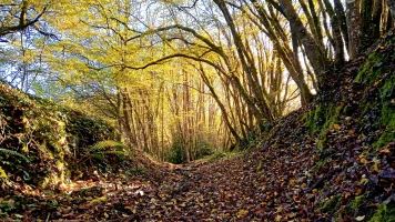
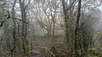
Being autumn-winter, trail surfaces were deep in leaves, muddy and sometimes slippery.

Re the trail, overall: Many hours a day along wide limestone tracks, bridle paths, between fields, and in the woods. Occassionally there were stretches on sealed lanes or a road.

There were many ascents and descents.

*Attention!
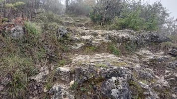
Chemin des Crêtes -the descent to Luzech:

After the archeological site, L'Oppidum there is a car park. It would be wise in wet weather to walk the road from there down to Luzech.

The descent to Luzech is stoney and steep. The surface is slipery when wet. A couple of times I found it safer to sit down and slither the path on my seat.

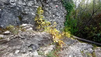
At the end of the descent, just before reaching the tower, above Luzech there is a chain stapled into the cliff face. The ledge was too slippery for me. I found it easier to slither down the rocks than to grip the chain and 'spider' the ledge.

*Ascent after Duelle: a little care is needed when wet.

Bon chemins, bon courage pèlerins!
-Lovingkindness.

20241125_154606.webp
Day 7 Chain and ledge, cliff above Luzech. (Between showers )

20241127_100624.webp
Day 9 Hours of fog & drizzle, after Saint-Vincent-Rive-d'Olt

20241127_120336.webp
Ascent after Duelle.
 
Last edited:

❓How to ask a question

How to post a new question on the Camino Forum.

Most read last week in this forum

Bonjour tout la monde! ...just before Christmas (2024) I set off along deserted trails for Rocamadour Sanctuary (Dordogne, France). I used old maps that showed roman roads and national trails...

Forum Zoom Chats

Join our Camino Forum Zoom chats every Tuesday. See the next one here.

❓How to ask a question

How to post a new question on the Camino Forum.

Forum Rules

Forum Rules

Camino Updates on YouTube

Camino Conversations

Most downloaded Resources

This site is run by Ivar at

in Santiago de Compostela.
This site participates in the Amazon Affiliate program, designed to provide a means for Ivar to earn fees by linking to Amazon
Official Camino Passport (Credential) | 2024 Camino Guides
Back
Top