• ⚠️ Emergency contact in Spain - Dial 112 and AlertCops app. More on this here.
  • Remove ads on the forum by becoming a donating member. More here.

Search 74,075 Camino Questions

camino Natural Santander - Mediterraneo

laineylainey

Veteran Member
Time of past OR future Camino
started in 2012, hooked ever since.
Travelling through Spain this last few months, in Oña, I noticed a path ad a board describing the "Camino Natural Santander ¡ Mediterráneo". I recognise it follows old disused railways lines and it looks flatish?
I just wonder if people have wlaked part of all of it and if they would recommend it? Having completed only 3 weeks of El Norte this September, I am thinking that a flatter route would suit me next year!
Thanks a lot.
 

Attachments

  • 20241120_155042.webp
    20241120_155042.webp
    324.5 KB · Views: 543
...and ship it to Santiago for storage. You pick it up once in Santiago. Service offered by Casa Ivar (we use DHL for transportation).
This Camino is not quite ready yet, still under construction. You'll walk or cycle along the old train tracks from Santander to Valencia. 22 tunnels along the way! One of them is over 6 kms long. Eeh.... 😱

From the website:
https://www.mapa.gob.es/es/desarrol...-noroeste/santander-mediterraneo/default.aspx

The Santander - Mediterranean Railway

This railway line was intended to link Santander with the Mediterranean ports of Sagunto and Valencia. The previous projects were the railways from Calatayud to Sagunto (F.C. Central de Aragón), in service since 1902, and the Astillero-Ontaneda, also inaugurated in 1902 and included in the Santander-Burgos railway project.

Later, in 1920, the Provincial Councils of Burgos, Santander, Soria and Zaragoza promoted the Santander-Mediterranean railway project, which consisted in the construction of the Ontaneda-Calatayud section, joining the section built years before in the north and the Calatayud-Teruel-Sagunto-Valencia line in the south.

Finally, between 1927 and 1930, the section from Calatayud to Cidad-Dosante station (Burgos), near Santelices, was built in its entirety. The connection with Santander remained incomplete with 35 km to go. In this last section, the 6,976-metre-long La Engaña tunnel stands out, the drilling of which was completed in 1959, being at the time the longest railway tunnel in Spain, although it was never used by any train.
A total of 22 tunnels built (of the 48 tunnels planned), 1st, 2nd and 3rd class stations, halts, sidings, depots, depots, crossings and hundreds of kilometres of track made up this unfinished route. In 1959, the works on the Santelices-Boo section (including the La Engaña tunnel) were abandoned and the section liquidated. On the constructed section, freight and passenger transport remained active until 1 January 1985, when the 434 km of the section between Cidad-Dosante and Caminreal were closed. Ten years later, in 1995, the Council of Ministers agreed to authorise the removal of the closed tracks, although this did not happen on the Santander-Mediterranean railway until 2003.

This former railway is currently being upgraded for hiking and cycling tourism, with the intention of finally linking the Cantabrian coastline with the Mediterranean coast through the Santander-Mediterranean Nature Trail.


santmed__tcm30-552379.png
 
Ideal sleeping bag liner whether we want to add a thermal plus to our bag, or if we want to use it alone to sleep in shelters or hostels. Thanks to its mummy shape, it adapts perfectly to our body.

€46,-
I have walked on bits and pieces of this trail - the part around Santelices is on the Olvidado, and the parts around Hontoria and San Leonardo are on the Castellano-Aragonés. I’ll bet there are more.

Wikiloc has a lot of tracks, many by cyclists. I am not sure you can piece together the whole thing with them, but there are big chunks, like this 262 km stretch.


I just did a wikiloc search for “camino natural santander mediterráneo” and a lot of tracks came up.

Sounds like a great idea, @laineylainey. I can’t remember what the steepest grade is, but RR tracks can’t get very steep, so they are great walking paths!
 
Get a spanish phone number with Airalo. eSim, so no physical SIM card. Easy to use app to add more funds if needed.
The 2024 Camino guides will be coming out little by little. Here is a collection of the ones that are out so far.
I have walked on bits and pieces of this trail - the part around Santelices is on the Olvidado, and the parts around Hontoria and San Leonardo are on the Castellano-Aragonés. I’ll bet there are more.

Wikiloc has a lot of tracks, many by cyclists. I am not sure you can piece together the whole thing with them, but there are big chunks, like this 262 km stretch.


I just did a wikiloc search for “camino natural santander mediterráneo” and a lot of tracks came up.

Sounds like a great idea, @laineylainey. I can’t remember what the steepest grade is, but RR tracks can’t get very steep, so they are great walking paths!
Thanks for that research @peregrina2000
We hope to be travelling around again next year in our campervan. It's so easy for my husband to drop me off and pick me up a few weeks later! Perhaps this is one I could do in chunks at different start and finish places.
I told myself if no one replied I would shelf the idea, but look now what's happened. Thanks to all for the positive feedback and information.
 
Travelling through Spain this last few months, in Oña, I noticed a path ad a board describing the "Camino Natural Santander ¡ Mediterráneo". I recognise it follows old disused railways lines and it looks flatish?
I just wonder if people have wlaked part of all of it and if they would recommend it? Having completed only 3 weeks of El Norte this September, I am thinking that a flatter route would suit me next year!
Thanks a lot.
Sounds like another one for my ever growing list!
 
...and ship it to Santiago for storage. You pick it up once in Santiago. Service offered by Casa Ivar (we use DHL for transportation).
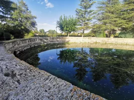
I enjoyed walking from Sagunto to Calatayub last year, much of it on the Santander-Mediterranean line. Very lovely, about 300km. Especially liked the sections from the spectacular source of the Jíloca (?largest artesian well in Europe?)

IMG_20231005_171633.webp

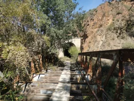
to its confluence with the Jálon at Calatayub. Bits are still a work in progress (I had to cross an old bridge slightly precariously as it hasn't yet been resurfaced, for example).

IMG_20231009_122544.webp

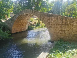
Teruel is a really lovely city (smallest provincial capital in Spain, and the province is one of the most sparsely populated). The odd Roman bridge on the way

IMG_20231007_121011.webp

and many other treats. The way from Sagunto to Teruel (the Vía Verde Ojos Negros) is almost entirely complete, although I often took the "straight and narrow" (and steep) path in preference to the Via Verde, as it was usually significantly shorter.

I think the last section of the Lana/Olav into Burgos is also on this route, as well as the bits around Soria that Laurie mentioned.
 

❓How to ask a question

How to post a new question on the Camino Forum.

Featured threads

❓How to ask a question

How to post a new question on the Camino Forum.

Forum Rules

Forum Rules

Camino Updates on YouTube

Camino Conversations

Most downloaded Resources

Featured threads

This site is run by Ivar at

in Santiago de Compostela.
This site participates in the Amazon Affiliate program, designed to provide a means for Ivar to earn fees by linking to Amazon
Official Camino Passport (Credential) | 2024 Camino Guides
Back
Top