• ⚠️ Emergency contact in Spain - Dial 112 and AlertCops app. More on this here.
  • Remove ads on the forum by becoming a donating member. More here.

Search 74,075 Camino Questions

Jakobweg/Gebennensis report Sept-Oct 2024

Bowmanfamily36

New Member
Time of past OR future Camino
Le Puy to SdC 2019, VF 2022 (Besancon to Rome)
Not sure where to post this ? Should it also be under the jakobweg?

My wife and I have recently completed a combined Jakobweg/ Via Gebennensis (VG) - starting at Lake Constance to Geneva and then onto Le Puy en Velay. Here are some things we believe others might find useful.
We started in mid Sept and finished at the end of October. So roughly 800 kms over 6 weeks. We are in our mid 60s and not the fastest walkers but this was slower than our two previous hikes (Le Puy to SdC in 2019) and Via Francigena from Besancon to Rome 2022.
The German part of Switzerland was tougher than we expected. We were also slow because the scenery is stunning and were constantly stopping for photos! But we were glad to take our time to appreciate it.
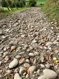
The VG didn’t have the same altitude differences but the path was very slow in parts with some murderous descents on loose, rocky paths or in mud after recent rains. The last kilometre into Chaumont took us 1 hour! Coming down into Yenne and then out on the long ascent the next day was brutal. If you don’t normally use walking poles then reconsider. During wet periods be prepared to walk through water. There was also about 3 days where the path invariably had these large round stones - impossible to walk fast on them and you will be cursing them by the end!
Guidebooks:
Are not needed in Switzerland - we used the Swiss Mobility app (free version - a friend used the paid version and found it less helpful than the free!) and mapy.cz app. It is impossible to get lost as the signage is so good!
The signage of the French VG also looked very shiny and new and we only went off track twice (got distracted!) . We didn’t have an app but used GPS Tracks.
Accommodation:
Switzerland is expensive but this can be mitigated somewhat by staying in the Pilger Herbeges , six of which are readily found, plus a lesser known one in Lausanne operated by a catholic parish. They were all truly excellent. Also we found monasteries and convents offered good value dinner, bed and breakfast. Food is also pricey so we cooked our own meals on most other nights.
Cost
Over 32 days we averaged (for the two of us in total) 92 chf per day, plus we bought our own food for breakfasts for 17 mornings and cooking own dinners for 23 nights.
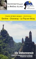
For the VG you MUST get the “Yellow Guide”. We bought ours in Geneva for 18e, and for 1e per day we found it indispensable for finding accommodation.
France is much cheaper and it seemed the standard price was 50e per person for dinner , bed and breakfast (Demi-pension) . We stayed in Gites, Chambre d’hotes and another type (unique to the VG?) called Accueil Jacquaire ARA. These are people who host pilgrims in their private homes. They are members of the association, friends of the Way ofStJames, and offer bed and breakfast and usually dinner with them on a donation basis. We gave them 100e per night for the two of us as they were great , and only one we gave 50e as the offering was less. We highly recommend that you research them beforehand.

However from mid October it is quite difficult to find accommodation that is still open. We don’t speak French but a kind lady in the tourist office in Bourg-Argental must have spent more than an hour telephoning places for the next two nights ahead for us! The Accueil Jacquaires listed in the Yellow Guide were a god-send. This is the main reason for buying the guidebook. Our hosts each night usually telephoned for the next village.
Just about everywhere on the VG was CASH ONLY. Note there are no ATMs between Geneva and Frangy (first 45kms) so top up BEFORE you leave the suburbs. There are also no supermarkets until Frangy, and actually somewhat limited throughout the whole VG as compared to Switzerland.
Rest days: we really enjoyed these - the afternoon in StGallen to visit the Abbey and its stunning library (our credencial gave us a discount), Bethanien, afternoon in Interlaken to visit Lauterbrunnen, Fribourg, Lausanne and Geneva (so much to see but we chose CERN, UN, and the Reformation Museum).

Summary: This walk didn’t have the same pilgrim feel as the other two as there wasn’t a sense of “arrival” and we met only a handful of other walkers in the 6 weeks (it was low season of course). However we were fortunate to walk the Swiss jakobweg section with another couple whom we met on the Francigena 2 years earlier. Overall the scenery was wonderful, the paths nearly always away from busy roads, the accommodation type was more varied and we enjoyed more personal contact with our hosts compared to previous trips and would recommend most of them. Message us if you want more details. There were some real gems which greatly added to our walking experience.
We would highly recommend this walk if you have already been to SdC and Rome and looking for something different. If possible don’t be in a hurry as there is so much to see.
 
Ideal sleeping bag liner whether we want to add a thermal plus to our bag, or if we want to use it alone to sleep in shelters or hostels. Thanks to its mummy shape, it adapts perfectly to our body.

€46,-
Hi,
Thanks for this, enjoyed it. I'm looking at doing Le Puy to ST Jean next year about the same time as you did this walk. Have already done St. Jean to SdeC. Is there any chance you could do a little reflection on your Le Puy walk similar to this? It would be most useful I'm sure.

Kind regards,
Les
 
Your excellent report is quite consistent with my own experience a few years pre-Covid. Were you able to try a "Schlaf im Stroh"?
I found the German-speaking Swiss would rather speak English than French, and the French-speaking Swiss would rather speak English than German. So, there tended to not be a language problem.
 
Fail to prepare? reduce your risk by buying this book full of practical info.
2nd ed.
Thank you so much for this detailed report, I'm now even more excited! Very useful to know about the "cash only" aspect, I hadn't really thought of that since so many places in Spain accept a "tap"; also the "no supermarkets until Frangy", good to know for planning purposes, I'll need to stock up

I am walking VG and Le Puy in Spring 2025, I never thought of starting further back in Lake Constance. Hmmmm.... if I weren't starting mid-April, I might have considered adding it, but I think it will be too early in the year...

Would love to see some highlight pics! DM me if you don't want to add here?
 
Swiss Mobility app (free version - a friend used the paid version and found it less helpful than the free!)
Thanks for your great summary. It remembers me of my own pilgrimage march 2017 from Constance to SdC and Porto.

The difference from the free version and the paid version of the Swiss Mobility app are:
- With the free version you are able to see all hiking tracks and you can use it online only.
- With the paid version you are able to create and store your own routes, import or export tracks and you are able to use it offline.
So the paid version is not worthwhile for someone who only wants to follow the Way of St. James #4.
 
We are planning to walk the Via G this spring (May). We too are seniors and while we consider the Via J., it looked like there was nothing but elevation every day. Great scenery but hard to appreciate when you are staring at the ground catching your breath.

We have done, among others - Le Puy and the Norte to Muxia and just finished two challenging walks in France back to back - The Stevenson and St Guilhem's Way - we have found "humping up and up then down and down" everyday, kinda lost its charm and so we were looking for a more "modest" challenge.

Wondering though how tough, i.e. how much elevation changes daily (generally speaking) - as mentioned based on our reading we decided against Via J but would love your take.

And it was my impression that Via G wasn't bad elevation wise - Yenne sounds bad but I'm wondering how bad as we did some pretty brutal ups and downs on the 4 walks i mentioned above.

Any isights specific or general greatly appreciated! The for your post
 
The one from Galicia (the round) and the one from Castilla & Leon. Individually numbered and made by the same people that make the ones you see on your walk.
And it was my impression that Via G wasn't bad elevation wise - Yenne sounds bad but I'm wondering how bad as we did some pretty brutal ups and downs on the 4 walks i mentioned above.
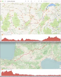
When you survived the Le Puy and the Norte than it will be fine. See the two pictures
Geneva to Le Puy on top and Le Puy to SjPP at the bottom

Geneve-lePuy-Sjpp.webp
 
Check my Blog elcaminohike for more details and informations. I found it was a nice hiking in this area. I did solo in April 2017 and didn't meet many pilgrims.
 
€2,-/day will present your project to thousands of visitors each day. All interested in the Camino de Santiago.
A very nice summary of both VJ and VG. I enjoyed both, though the scenery of the VJ (especially the german part) is hard to top.

Except for the very steep descend into Schwyz (part of which can be avoided), I think those rolling stone descends on the VG were worse. Walking poles or a staff are good choices on both routes.

Of course it depends on the budget but VJ can be done in shorter stages of maybe 10-15km, if necessary.

There are several informative threads here on the forum for both routes, plus some useful resources.
Hi Camika - I'm interested in your experience as I discarded walking this route because I thought it would be too tough.

My wife and I are seniors, mid 60s, but we are experienced Camino hikers.
We have completed the Norte, Le Puy and several others... I must say after a while, I get weary of constant ascending and descending and thought this route, while spectacular, was just a lot more of that,

How difficult is the route? How difficult can you compare to any of the hikes in Spain?

Thanks for any info you can supply.
 
A very nice summary of both VJ and VG. I enjoyed both, though the scenery of the VJ (especially the german part) is hard to top.

Except for the very steep descend into Schwyz (part of which can be avoided), I think those rolling stone descends on the VG were worse. Walking poles or a staff are good choices on both routes.

Of course it depends on the budget but VJ can be done in shorter stages of maybe 10-15km, if necessary.

There are several informative threads here on the forum for both routes, plus some useful resources.
Hi Caminka
Yes it was the three days of round pebbles on the VG that were the worst! And the descent into Wattwil where we ended up alternating between walking backwards to save our shins!
Thanks for all the resources you have uploaded on the forum - we used them a lot.
 
The one from Galicia (the round) and the one from Castilla & Leon. Individually numbered and made by the same people that make the ones you see on your walk.
Hi Camika - I'm interested in your experience as I discarded walking this route because I thought it would be too tough.

My wife and I are seniors, mid 60s, but we are experienced Camino hikers.
We have completed the Norte, Le Puy and several others... I must say after a while, I get weary of constant ascending and descending and thought this route, while spectacular, was just a lot more of that,

How difficult is the route? How difficult can you compare to any of the hikes in Spain?

Thanks for any info you can supply.
Check this posts:
Post in thread 'Joining Freiburg im Breisgau with Motz on the Via Gebennensis' https://www.caminodesantiago.me/com...otz-on-the-via-gebennensis.87364/post-1265167

Post in thread 'Jakobsweg/ Via Jacobi Switzerland from Rorschach to Geneva' https://www.caminodesantiago.me/com...nd-from-rorschach-to-geneva.33485/post-345818

Post in thread 'Jakobsweg/ Via Jacobi Switzerland from Rorschach to Geneva' https://www.caminodesantiago.me/com...d-from-rorschach-to-geneva.33485/post-1297127

And for some reason I can't find my post describing the ups and downs of VJ. 🤔
 
Last edited:
Hi Caminka
Yes it was the three days of round pebbles on the VG that were the worst! And the descent into Wattwil where we ended up alternating between walking backwards to save our shins!
Thanks for all the resources you have uploaded on the forum - we used them a lot.
You're welcome. :)

Yea, descends can really be something sometimes, and it usually only gets worse with erosion and use. That's why I always have a staff or poles, helps a lot. I have done backwards walking on occasion, too, it helps with relaxing the hard working muscles, whether up or down.
 
Get a spanish phone number with Airalo. eSim, so no physical SIM card. Easy to use app to add more funds if needed.
Wondering though how tough, i.e. how much elevation changes daily (generally speaking) - as mentioned based on our reading we decided against Via J but would love your take.
One of the advantages of growing up in a mountainous country and doing a lot of hiking and trail running is that you not only get fit but also stay fit. Say one at the age of 68.
The trail from Rohrschach has a little more elevation gain than the one from Constance, but the length is about the same.
Details can be found on our map schweizmobil or on Swiss Way of St. James
 
Hi Camika - I'm interested in your experience as I discarded walking this route because I thought it would be too tough.

My wife and I are seniors, mid 60s, but we are experienced Camino hikers.
We have completed the Norte, Le Puy and several others... I must say after a while, I get weary of constant ascending and descending and thought this route, while spectacular, was just a lot more of that,

How difficult is the route? How difficult can you compare to any of the hikes in Spain?

Thanks for any info you can supply.
Found the post with ups and down: https://www.caminodesantiago.me/community/threads/need-some-new-route-advice.87347/post-1264966.

I could say that the first part of the norte Norte till Bilbao is pretty much up and down too, although perhaps not so much height is gained or lost. the Frances has its share of steep ups and downs which can be quite comparable in steepness (down to Zubiri, Uterga, Molinaseca) and two longer climbs (from SJPP and from Astorga) but is mostly rolling hills otherwise. Switzerland is mountains, so one would expect it to be more mountaineous (and I loved it for it).
 
Those devilish "round pebbles" are the size of avocados and make very tricky footing, especially going downhill and even more so when wet.
The scenery in the eastern half of Switzerland along the Via Jacobi is the most striking, well worth the pain.
The Swiss post interesting signs, like "Destination X 2 hours, Destination Y 4 hours". Do not believe them -- they are meant for Swiss legs, not mine!
 
Ideal sleeping bag liner whether we want to add a thermal plus to our bag, or if we want to use it alone to sleep in shelters or hostels. Thanks to its mummy shape, it adapts perfectly to our body.

€46,-
We are planning to walk the Via G this spring (May). We too are seniors and while we consider the Via J., it looked like there was nothing but elevation every day. Great scenery but hard to appreciate when you are staring at the ground catching your breath.

We have done, among others - Le Puy and the Norte to Muxia and just finished two challenging walks in France back to back - The Stevenson and St Guilhem's Way - we have found "humping up and up then down and down" everyday, kinda lost its charm and so we were looking for a more "modest" challenge.

Wondering though how tough, i.e. how much elevation changes daily (generally speaking) - as mentioned based on our reading we decided against Via J but would love your take.

And it was my impression that Via G wasn't bad elevation wise - Yenne sounds bad but I'm wondering how bad as we did some pretty brutal ups and downs on the 4 walks i mentioned above.

Any isights specific or general greatly appreciated! The for your post
For us at least it is not the size of elevation gains but rather the steepness. We actually prefer the ups and downs compared to a day of flat walking on tarmac because our legs are getting a more balanced workout. And the steeper gradients are still OK if we have allowed sufficient time and are not in a hurry. The good thing about the VJ is that you can plan your stages to suit your walking speed and time available. And the scenery is simply spectacular! So while all Caminos have their own set of particular tough sections, the VJ’s overall terrain just meant that we needed to dial back our stage length most days. So it wasn’t a negative at all. The same can be said for the VG where some topography and track conditions just slowed us down , probably more than we expected. The days with greatest climbs on the VG ( Le Setoux and Raffy ) however were pretty easy. For both VJ and VG, the weather plays a more important role than say the CF.
We prefer longer walks as airfares from Australia are expensive. So we wanted at least an 800km route or longer so the combined VJ and VG was great. Kitsambler’s and Caminka’s blogs gave us the inspiration. We were also planning on continuing with the Stevenson but were advised that most accommodation was closed for the season so we had to bail out.
BTW what was your itinerary for the combined Stevenson and Guilhem? A friend of ours raved about the latter!
 
the three days of round pebbles on the VG
Can I ask what stages those are? Are they 3 consecutive days? Not too worried about the uphill, it's the downhill that drives me crazy, especially when it takes about an hour to walk a mile - I had a hike like that in on Lake Como near Bellagio, I definitely was feeling angry towards the end, and my knees really suffered after 4 hours of steady downhill, poles help but they were sandy and slippery, I really worried I would fall and injure myself in the middle of nowhere. Hoping these 3 days won't be quite as bad! (yikes!)
 
For us at least it is not the size of elevation gains but rather the steepness. We actually prefer the ups and downs compared to a day of flat walking on tarmac because our legs are getting a more balanced workout. And the steeper gradients are still OK if we have allowed sufficient time and are not in a hurry. The good thing about the VJ is that you can plan your stages to suit your walking speed and time available. And the scenery is simply spectacular! So while all Caminos have their own set of particular tough sections, the VJ’s overall terrain just meant that we needed to dial back our stage length most days. So it wasn’t a negative at all. The same can be said for the VG where some topography and track conditions just slowed us down , probably more than we expected. The days with greatest climbs on the VG ( Le Setoux and Raffy ) however were pretty easy. For both VJ and VG, the weather plays a more important role than say the CF.
We prefer longer walks as airfares from Australia are expensive. So we wanted at least an 800km route or longer so the combined VJ and VG was great. Kitsambler’s and Caminka’s blogs gave us the inspiration. We were also planning on continuing with the Stevenson but were advised that most accommodation was closed for the season so we had to bail out.
BTW what was your itinerary for the combined Stevenson and Guilhem? A friend of ours raved about the latter!
Like you we like the longer walks - having done the Francis, Norte and Le Puy all 800+) we decided to try and max our hiking time. Actually we did three walks back to back - perhaps a little ambitious in hindsight

We started last week of April (because when we walked Le Puy we ran into really brutally hot weather) yet this time (2024, same starting point) it was very cold and very very wet. When we had to climb through a mountain pass we hit a blizzard, total white out. Anyway with the climbs and the unrelenting rain it was a beautiful slog - and I believe we did an aggressive 10 day schedule vs. 12

We then did a week of hiking through a place called The Tarn River Gorge - Unesco site and a well kept secret. Some Aussie's told us about it when we walked Le Puy

From there we took a train a little north and did St Guilhem - a damn tough hike

I can't remember our itinerary but we followed what was layed out from a company called the Enlightened Traveller - they post these walks with details and an itinerary

Hope this helps
 
Get a spanish phone number with Airalo. eSim, so no physical SIM card. Easy to use app to add more funds if needed.
Not sure where to post this ? Should it also be under the jakobweg?

My wife and I have recently completed a combined Jakobweg/ Via Gebennensis (VG) - starting at Lake Constance to Geneva and then onto Le Puy en Velay. Here are some things we believe others might find useful.
We started in mid Sept and finished at the end of October. So roughly 800 kms over 6 weeks. We are in our mid 60s and not the fastest walkers but this was slower than our two previous hikes (Le Puy to SdC in 2019) and Via Francigena from Besancon to Rome 2022.
The German part of Switzerland was tougher than we expected. We were also slow because the scenery is stunning and were constantly stopping for photos! But we were glad to take our time to appreciate it.
The VG didn’t have the same altitude differences but the path was very slow in parts with some murderous descents on loose, rocky paths or in mud after recent rains. The last kilometre into Chaumont took us 1 hour! Coming down into Yenne and then out on the long ascent the next day was brutal. If you don’t normally use walking poles then reconsider. During wet periods be prepared to walk through water. There was also about 3 days where the path invariably had these large round stones - impossible to walk fast on them and you will be cursing them by the end!
Guidebooks:
Are not needed in Switzerland - we used the Swiss Mobility app (free version - a friend used the paid version and found it less helpful than the free!) and mapy.cz app. It is impossible to get lost as the signage is so good!
The signage of the French VG also looked very shiny and new and we only went off track twice (got distracted!) . We didn’t have an app but used GPS Tracks.
Accommodation:
Switzerland is expensive but this can be mitigated somewhat by staying in the Pilger Herbeges , six of which are readily found, plus a lesser known one in Lausanne operated by a catholic parish. They were all truly excellent. Also we found monasteries and convents offered good value dinner, bed and breakfast. Food is also pricey so we cooked our own meals on most other nights.
Cost
Over 32 days we averaged (for the two of us in total) 92 chf per day, plus we bought our own food for breakfasts for 17 mornings and cooking own dinners for 23 nights.
For the VG you MUST get the “Yellow Guide”. We bought ours in Geneva for 18e, and for 1e per day we found it indispensable for finding accommodation.
France is much cheaper and it seemed the standard price was 50e per person for dinner , bed and breakfast (Demi-pension) . We stayed in Gites, Chambre d’hotes and another type (unique to the VG?) called Accueil Jacquaire ARA. These are people who host pilgrims in their private homes. They are members of the association, friends of the Way ofStJames, and offer bed and breakfast and usually dinner with them on a donation basis. We gave them 100e per night for the two of us as they were great , and only one we gave 50e as the offering was less. We highly recommend that you research them beforehand.

However from mid October it is quite difficult to find accommodation that is still open. We don’t speak French but a kind lady in the tourist office in Bourg-Argental must have spent more than an hour telephoning places for the next two nights ahead for us! The Accueil Jacquaires listed in the Yellow Guide were a god-send. This is the main reason for buying the guidebook. Our hosts each night usually telephoned for the next village.
Just about everywhere on the VG was CASH ONLY. Note there are no ATMs between Geneva and Frangy (first 45kms) so top up BEFORE you leave the suburbs. There are also no supermarkets until Frangy, and actually somewhat limited throughout the whole VG as compared to Switzerland.
Rest days: we really enjoyed these - the afternoon in StGallen to visit the Abbey and its stunning library (our credencial gave us a discount), Bethanien, afternoon in Interlaken to visit Lauterbrunnen, Fribourg, Lausanne and Geneva (so much to see but we chose CERN, UN, and the Reformation Museum).

Summary: This walk didn’t have the same pilgrim feel as the other two as there wasn’t a sense of “arrival” and we met only a handful of other walkers in the 6 weeks (it was low season of course). However we were fortunate to walk the Swiss jakobweg section with another couple whom we met on the Francigena 2 years earlier. Overall the scenery was wonderful, the paths nearly always away from busy roads, the accommodation type was more varied and we enjoyed more personal contact with our hosts compared to previous trips and would recommend most of them. Message us if you want more details. There were some real gems which greatly added to our walking experience.
We would highly recommend this walk if you have already been to SdC and Rome and looking for something different. If possible don’t be in a hurry as there is so much to see.
I certainly agree that the Yellow Guide is needed for the VG. I ordered it online but it arrived too late to take it with us on the VG last year. The Yellow Guide would have saved us a lot of money on accommodation as it lists all the hostels and AJs. Not having access to this list meant we had to stay in a lot of hotels and B&Bs which were a lot more expensive. Eventually we stayed in a place with an old yellow guide book and I took photos of the hostel list which made the rest of the walk a LOT easier and cheaper!
 
Not sure where to post this ? Should it also be under the jakobweg?

My wife and I have recently completed a combined Jakobweg/ Via Gebennensis (VG) - starting at Lake Constance to Geneva and then onto Le Puy en Velay. Here are some things we believe others might find useful.
We started in mid Sept and finished at the end of October. So roughly 800 kms over 6 weeks. We are in our mid 60s and not the fastest walkers but this was slower than our two previous hikes (Le Puy to SdC in 2019) and Via Francigena from Besancon to Rome 2022.
The German part of Switzerland was tougher than we expected. We were also slow because the scenery is stunning and were constantly stopping for photos! But we were glad to take our time to appreciate it.
The VG didn’t have the same altitude differences but the path was very slow in parts with some murderous descents on loose, rocky paths or in mud after recent rains. The last kilometre into Chaumont took us 1 hour! Coming down into Yenne and then out on the long ascent the next day was brutal. If you don’t normally use walking poles then reconsider. During wet periods be prepared to walk through water. There was also about 3 days where the path invariably had these large round stones - impossible to walk fast on them and you will be cursing them by the end!
Guidebooks:
Are not needed in Switzerland - we used the Swiss Mobility app (free version - a friend used the paid version and found it less helpful than the free!) and mapy.cz app. It is impossible to get lost as the signage is so good!
The signage of the French VG also looked very shiny and new and we only went off track twice (got distracted!) . We didn’t have an app but used GPS Tracks.
Accommodation:
Switzerland is expensive but this can be mitigated somewhat by staying in the Pilger Herbeges , six of which are readily found, plus a lesser known one in Lausanne operated by a catholic parish. They were all truly excellent. Also we found monasteries and convents offered good value dinner, bed and breakfast. Food is also pricey so we cooked our own meals on most other nights.
Cost
Over 32 days we averaged (for the two of us in total) 92 chf per day, plus we bought our own food for breakfasts for 17 mornings and cooking own dinners for 23 nights.
For the VG you MUST get the “Yellow Guide”. We bought ours in Geneva for 18e, and for 1e per day we found it indispensable for finding accommodation.
France is much cheaper and it seemed the standard price was 50e per person for dinner , bed and breakfast (Demi-pension) . We stayed in Gites, Chambre d’hotes and another type (unique to the VG?) called Accueil Jacquaire ARA. These are people who host pilgrims in their private homes. They are members of the association, friends of the Way ofStJames, and offer bed and breakfast and usually dinner with them on a donation basis. We gave them 100e per night for the two of us as they were great , and only one we gave 50e as the offering was less. We highly recommend that you research them beforehand.

Hi @Bowmanfamily36 , thanks for sharing your experience. If you decide to write a blog about it or have photos , please do share. I’m still researching this route and would appreciate your help understanding the following…

1) Where can I find out more about the Yellow Guide? I googled it but can’t seem to find info on it (at least not what I was expecting). Do you have a web link so i can read more about it?

2) I saw your note about the need for cash. How often/common did you find ATMs (other than between Geneva and Frangy)? Given the need for cash, how much do you recommend having on hand between ATM stages?

Thanks!
 
was
Hi @Bowmanfamily36 , thanks for sharing your experience. If you decide to write a blog about it or have photos , please do share. I’m still researching this route and would appreciate your help understanding the following…

1) Where can I find out more about the Yellow Guide? I googled it but can’t seem to find info on it (at least not what I was expecting). Do you have a web link so i can read more about it?

2) I saw your note about the need for cash. How often/common did you find ATMs (other than between Geneva and Frangy)? Given the need for cash, how much do you recommend having on hand between ATM stages?

Thanks!
 
...and ship it to Santiago for storage. You pick it up once in Santiago. Service offered by Casa Ivar (we use DHL for transportation).
Can I ask what stages those are? Are they 3 consecutive days? Not too worried about the uphill, it's the downhill that drives me crazy, especially when it takes about an hour to walk a mile - I had a hike like that in on Lake Como near Bellagio, I definitely was feeling angry towards the end, and my knees really suffered after 4 hours of steady downhill, poles help but they were sandy and slippery, I really worried I would fall and injure myself in the middle of nowhere. Hoping these 3 days won't be quite as bad! (yikes!)
I recall it was around Valencogne to Le Grand Lemps and onto Faramans and Revel-Tourdan. caused by a glacier long ago. Apart from the descent into le Grand Lemps I think the track was fairly level , but just slow on the stones and I got my only blister from them.
 
Fail to prepare? reduce your risk by buying this book full of practical info.
2nd ed.
Hi @Bowmanfamily36 , thanks for sharing your experience. If you decide to write a blog about it or have photos , please do share. I’m still researching this route and would appreciate your help understanding the following…

1) Where can I find out more about the Yellow Guide? I googled it but can’t seem to find info on it (at least not what I was expecting). Do you have a web link so i can read more about it?

2) I saw your note about the need for cash. How often/common did you find ATMs (other than between Geneva and Frangy)? Given the need for cash, how much do you recommend having on hand between ATM stages?

Thanks!
We bought the Yellow Guide in Geneva at a bookshop called Payot (there is one at the railway station and another nearby in the city ).
Each day we spent 100e for us as a couple for the demi-pension, so we just needed a bit more for lunch and snacks. After Frangy there was no problem getting cash out. The Yellow Guide has a 6 page section which shows a summary of all the services (eg bank, groceries,) for every town you pass through. It also has details of where to find water. It did allow us to plan ahead.
 
Can I ask what stages those are? Are they 3 consecutive days? Not too worried about the uphill, it's the downhill that drives me crazy, especially when it takes about an hour to walk a mile - I had a hike like that in on Lake Como near Bellagio, I definitely was feeling angry towards the end, and my knees really suffered after 4 hours of steady downhill, poles help but they were sandy and slippery, I really worried I would fall and injure myself in the middle of nowhere. Hoping these 3 days won't be quite as bad! (yikes!)
Here is a picture of the infamous pebbles!
 

Attachments

  • IMG_4607.webp
    IMG_4607.webp
    1.5 MB · Views: 0
Thank you so much for this detailed report, I'm now even more excited! Very useful to know about the "cash only" aspect, I hadn't really thought of that since so many places in Spain accept a "tap"; also the "no supermarkets until Frangy", good to know for planning purposes, I'll need to stock up

I am walking VG and Le Puy in Spring 2025, I never thought of starting further back in Lake Constance. Hmmmm.... if I weren't starting mid-April, I might have considered adding it, but I think it will be too early in the year...

Would love to see some highlight pics! DM me if you don't want to add here?
For photos it would be hard to go past this extremely detailed blog on each section along with pictures:
Enjoy!
 
A selection of Camino Jewellery
@Bowmanfamily36 Hi Fellow Aussies! thanks for posting this - my husband and I are planning to walk the VG in a couple of years and I am thirsty for any information I can get! Can you post a pic or tell me the name of the 'yellow book' you mentioned?

thanks
 
...and ship it to Santiago for storage. You pick it up once in Santiago. Service offered by Casa Ivar (we use DHL for transportation).

❓How to ask a question

How to post a new question on the Camino Forum.

Featured threads

❓How to ask a question

How to post a new question on the Camino Forum.

Forum Rules

Forum Rules

Camino Updates on YouTube

Camino Conversations

Most downloaded Resources

Featured threads

This site is run by Ivar at

in Santiago de Compostela.
This site participates in the Amazon Affiliate program, designed to provide a means for Ivar to earn fees by linking to Amazon
Official Camino Passport (Credential) | 2024 Camino Guides
Back
Top