• ⚠️ Emergency contact in Spain - Dial 112 and AlertCops app. More on this here.
  • Remove ads on the forum by becoming a donating member. More here.

Search 74,075 Camino Questions

Detours to Javier Castle, Leyre Monastery, and Foz de Lumbier

peregrina2000

Moderator
Staff member
I have had several conversations on various threads about these options, and I thought I’d put it all in one place for anyone who is contemplating the same thing or who might be enticed to contemplate the same thing once they see how amazing these destinations are.

I also want to preface this by saying that I know that there are many who prefer to stick to the camino and don’t have any interest in the detours that I typically come up with. That’s fine, I get that, but for anyone who is more like me…. here goes.

From Ruesta on the Aragonés, the next official Camino Aragonés destination is Sangüesa, and the Camino passes through the town of Undúes de Lerda, for a total stage of about 24 km with about 600 m elevation gain. A fairly manageable stage for many people.

North of the Camino near Undúes de Lerda are two important historical sites - the Castillo de Javier, and the Monasterio de Leyre. Wikiloc showed me how easy it is to branch off and visit them both.

From Ruesta to Javier Castle, it is about 18 km, shown on this wikiloc track (it leaves the camino somewhere after Undúes de Lerda). The track goes all the way back to Sangüesa from the Castle, so only the first part of the track will be needed to get to the castle.


From Javier Castle to the monastery, it is about 11 or 12 km.


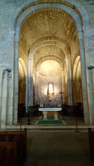
Some would do that 30 km in one day (like the younger me); others would want to do it in two days to have time to visit the castle on the day from Ruesta and then have plenty of time to visit the Monastery the next day. I have visited the monastery twice and can say is a 5 star attraction, at least for those who like ancient churches. I really want to WALK there, though!

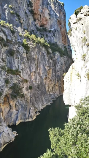
From the monastery, it’s easy to either take a trail which takes you back to the Aragonés at Sangüesa, or if you are like me and have already been in Sangüesa, you can go directly from the monastery to the entrance to the Foz de Lumbier.

Here’s a trail that would go from monastery to Sangüesa back through the Javier Castle.


Monastery to Sangüesa would be about 17 km. Then you decide whether to take the Lumbier alternative or not.

If you don’t care about going through Sangüesa, you can walk from the Monastery directly to the entrance to the Foz de Lumbier in two ways.

The difficult way goes up across a ridge, and then down to the entrance to the tunnel.


That is about 17 km and involves a difficult climb with chains, total elevation gain about 1100 m.

The route that @Vacajoe (I think) and others have walked goes from the Monastery through Yesa, and through Liedena, and then on to the start of the gorge trail. That route is here:


That would be about 18 km from the Monastery, through the gorge, and to the town of Lumbier. The tracks I linked to went further on to Monreal (for a total of about 37), which my current self would probably not do, but a stop in Lumbier is recommended by many on the forum anyway.

Once in Lumbier, you will rejoin the official camino at some spot before Izco and would have a 23 km day from Lumbier to Monreal.

One other thing to throw out — if you haven’t been to Sangüesa (and it does have a nice Romanesque portal on its church), you can easily get from the monastery to Sangüesa (17 km) and then 10 more to Lumbier. That means that going from Leyre through Sangüesa would be a 27 km day to Lumbier, while the off-camino route would be 18.

And one last thing - there is a ridge trail that goes from Leyre to Lumbier but does not go through the gorge.

Choices, choices! I am putting all of this into one post, more for myself than anything so that when I am actually ready to contemplate these choices, all of the information will be in one place. Right now I am in the dreaming stage, but this is my hope for 2025!

Thanks to @Vacajoe and others for their help focusing me on this alternative. I would love to hear from others with different ideas about this segment!
 
A selection of Camino Jewellery
I wish I had this information when I walked the Aragonés in 2022. I tried going to Foz de Lumbier with the information on Gronze then, but I followed the arrows instead of going straight out of Sangüesa and missed it. I visited the Foz de Lumbier this year though on my own, and it was well worth the detour and worth the visit. Still have the monastery and castillo on my bucket list though. Thanks for the info and many others will appreciate it!
 
Yesa is between Javier and Leyre so there are other places to stop between the two places. (There's an albergue in Yesa.)We stayed at one of the smaller hotels in Javier 2 years ago and in 2018, Phil stayed at the church run facility in Javier for a hospitalero encuentro.

We have also stayed at the hotel at Leyre and it is very nice.
 
Fail to prepare? reduce your risk by buying this book full of practical info.
2nd ed.
Be aware that in March there will be tens of thousands of pilgrims participating in La Javierada, a romeía (mini-pilgrimage), that goes to the Castle of Javier in honor of Saint Francis of Javier. Many will pass through Sangüesa. There is a two day romeía and a one day romeía a week later.

There is a fairly long article on the Javierada on the Spanish Wikipedia.
https://es.wikipedia.org/wiki/Javierada
 
Be aware that in March there will be tens of thousands of pilgrims participating in La Javierada, a romeía (mini-pilgrimage), that goes to the Castle of Javier in honor of Saint Francis of Javier. Many will pass through Sangüesa.
Good tip, thanks. I hope to walk in late spring/early summer and expect there will be a lot of tourists, but I would like to avoid a romería.
 
Ideal pocket guides for during & after your Camino. Each weighs only 1.4 oz (40g)!
I have had several conversations on various threads about these options, and I thought I’d put it all in one place for anyone who is contemplating the same thing or who might be enticed to contemplate the same thing once they see how amazing these destinations are.

I also want to preface this by saying that I know that there are many who prefer to stick to the camino and don’t have any interest in the detours that I typically come up with. That’s fine, I get that, but for anyone who is more like me…. here goes.

From Ruesta on the Aragonés, the next official Camino Aragonés destination is Sangüesa, and the Camino passes through the town of Undúes de Lerda, for a total stage of about 24 km with about 600 m elevation gain. A fairly manageable stage for many people.

North of the Camino near Undúes de Lerda are two important historical sites - the Castillo de Javier, and the Monasterio de Leyre. Wikiloc showed me how easy it is to branch off and visit them both.

From Ruesta to Javier Castle, it is about 18 km, shown on this wikiloc track (it leaves the camino somewhere after Undúes de Lerda). The track goes all the way back to Sangüesa from the Castle, so only the first part of the track will be needed to get to the castle.


From Javier Castle to the monastery, it is about 11 or 2 km km.


Some would do that 30 km in one day (like the younger me); others would want to do it in two days to have time to visit the castle on the day from Ruesta and then have plenty of time to visit the Monastery the next day. I have visited the monastery twice and can say is a 5 star attraction, at least for those who like ancient churches. I really want to WALK there, though!

From the monastery, it’s easy to either take a trail which takes you back to the Aragonés at Sangüesa, or if you are like me and have already been in Sangüesa, you can go directly from the monastery to the entrance to the Foz de Lumbier.

Here’s a trail that would go from monastery to Sangüesa back through the Javier Castle.


Monastery to Sangüesa would be about 17 km. Then you decide whether to take the Lumbier alternative or not.

If you don’t care about going through Sangüesa, you can walk from the Monastery directly to the entrance to the Foz de Lumbier in two ways.

The difficult way goes up across a ridge, and then down to the entrance to the tunnel.


That is about 17 km and involves a difficult climb with chains, total elevation gain about 1100 m.

The route that @Vacajoe (I think) and others have walked goes from the Monastery through Yesa, and through Liedena, and then on to the start of the gorge trail. That route is here:


That would be about 18 km from the Monastery, through the gorge, and to the town of Lumbier. The tracks I linked to went further on to Monreal (for a total of about 37), which my current self would probably not do, but a stop in Lumbier is recommended by many on the forum anyway.

Once in Lumbier, you will rejoin the official camino at some spot before Izco and would have a 23 km day from Lumbier to Izco.

One other thing to throw out — if you haven’t been to Sangüesa (and it does have a nice Romanesque portal on its church), you can easily get from the monastery to Sangüesa (17 km) and then 10 more to Lumbier. That means that going from Leyre through Sangüesa would be a 27 km day to Lumbier, while the off-camino route would be 18.

And one last thing - there is a ridge trail that goes from Leyre to Lumbier but does not go through the gorge.

Choices, choices! I am putting all of this into one post, more for myself than anything so that when I am actually ready to contemplate these choices, all of the information will be in one place. Right now I am in the dreaming stage, but this is my hope for 2025!

Thanks to @Vacajoe and others for their help focusing me on this alternative. I would love to hear from others with different ideas about this segment!
Thanks @peregrina2000 I have been planning to walk tha Catalan and Aragonés beginning in April 2025. Your suggestions sound really attractive. Having completed these caminos before would you or others have a comment about how busy the routes might be in April/May?
Many thanks for all your research.
 
I managed to combine Leyre and the Foz de Lumbier, but skipped Javier. Went from Santa Cilia de Jaca to Berdún, where there was a quite nice hostal (and where pilgrims coming over the Pyrenees by Puerto de Palo on a Roman road used to arrive). Berdún to Leyre along the north side of the reservoir, and I think I was helped by the reservoir being abnormally low, so able to walk partly on the usually submerged route. Then from Leyre to Sangüesa vía Lumbier (excellent lunch) and then the Foz, and on to Sangüesa. Using Mikel Olivares' wikiloc. Loved the Foz. And Leyre.

DSC_0550.webpDSC_0519.webp
 
...and ship it to Santiago for storage. You pick it up once in Santiago. Service offered by Casa Ivar (we use DHL for transportation).
I managed to combine Leyre and the Foz de Lumbier, but skipped Javier. Went from Santa Cilia de Jaca to Berdún, where there was a quite nice hostal (and where pilgrims coming over the Pyrenees by Puerto de Palo on a Roman road used to arrive).
Oh, great, another option. Thanks, Alan!

I had decided not to consider the “north side of the reservoir route”, but your post suggests that I should.

Santa Cilia to Berdún looks like a lot of off-road, nice and short, 16 flat kms.


Berdún to Monastery is a long 40-ish kms. Relatively flat with a 300 m ascent at the end.


There is a Casa Rural in Sigüés, La Maestra, pricey but it’s better than nothing to break up the stage from Berdun to the Monastery pretty evenly.

Javier and its castle are easy to add to this routing if you want to go to Sangüesa, because the walking route from Leyre to Sangüesa goes through Javier. Then from Sangüesa take the route to the Foz that so many forum members have already done and raved about!

So that’s one more option for folks to consider. Glad I have so many months to mull it over.
 
Fail to prepare? reduce your risk by buying this book full of practical info.
2nd ed.
At the Sangüesa albergue in 2019 the hospitelera told us pilgrims that there was a nearby early bus that would take us part way to the Foz de Lumbier. If you have a lot of walking to do that day this could save you somewhere from an hour to two hours of walking.

I did a bit of searching for this bus this afternoon and it appears to be the ones going between Sangüesa and Pamplona. Google Maps shows a Sangüesa bus that stops at a gas station outside Liédena. Here's info on the busline:


Use this information at your own risk but the little I have here may save you some search time on your own.
 
I took the bus from that gas station several years ago. My reason was I had not gone to an ATM in Jaca to top up my cash and I was basically running on empty. There are no ATM on the Aragones except in larger towns. At any rate, and it may have been on a weekend, I'm not sure; the scheduled bus never showed up and at one point I was ready to walk to Lumbier after waiting for the bus to show up. Suddenly a bus showed up from the road from the north and I was able to go to Pamplona to find an ATM. I will admit, I saw an ATM from the bus window in Lumbier but at that point I was exhausted after my overly long wait at said gas station.
 
We have also stayed at the hotel at Leyre and it is very nice.
I see on the monastery website that the hotel is closed for renovation. I can't find too much else about it on the internet, but see that the RFP for the first phase of renovation just went out this June. So my guess is that this will not be an option for sleeping for a few years.

So it looks like Yesa would be the best place to sleep, what a shame. I remember going to the nighttime service (completas?) in a dark church at the monastery and it was something else.
 
The one from Galicia (the round) and the one from Castilla & Leon. Individually numbered and made by the same people that make the ones you see on your walk.
My wife and I walked the north side of the Yesa embalse a few years ago (Leyre to Undues) and it was the single hardest day of ten routes we have walked. Zero support: no food, no water, No cafes, no anything. Humbling and difficult. I rarely recommend NOT doing things, but this is one part I’d suggest you skip
 
I walked the northern side of the Yesa reservoir in 2012. I slept in Arres, crossed over after Artieda and then followed the road via Tiebas and a camping. It was very hot. There was a bar in the camping and I bought 1.5l bottle of cold water just to cool myself down on the outside. Here I enquired about the options of crossing the constructuon site for the motorway and was told that the gravel/forest roads up to the monastery were likely blocked. Someone offered to drive me up via one of those roads, just in case, and that's how I skipped walking the last climb. This should not be an issue any more.
I had great fortune and slept in the monastery itself, in a small room reserved for passing pilgrims or people in need (I remember the hospitalero monk told me a homeless person stayed there a few nights before I came). I was given a simple dinner and had an interesting conversarion with the hospitalero. Perhaps it's worth enquiring if this option still exists.
Of course I took a guided toor of the church and the crypt, and it was wonderful to be there after the tourist buses left.


The next day I descended to Yesa then walked via Javier to Sanguesa. I think I was too early in Javier for the opening times.

 
Last edited:
I definitely can attest to the fact that there is no support along the north side of the lake. I could see that from the bus as I made my way to Pamplona and I have also driven it one time when I visited San de la Pena from my home in Biarritz after spending the night at the monastery in Leyre. Sorry to hear it closed, the evening activities are amazing and the dinner I had in their dining room was a feast.
 
Perfect memento/gift in a presentation box. Engraving available, 25 character max.
Just heard from the Monastery that the renovations will take two or three years. The monastic lodging, as @Vacajoe already told us, is for men only with a two night minimum. The room @caminka described is specifically designated as a place for homeless/transeunte, but the very nice person on WhatsApp said he would explore this more with the person in charge of the room. I explained that I wasn’t going to be walking any time soon but was just interested in scoping out the lay of the land.

I don’t mind staying in Yesa, but I think it makes it hard to get up for a nighttime service, because walking back in the dark would not be a good idea. I’ve searched for taxis and there don’t seem to be any. My guess is that I would find someone in the parking lot after completas to take me to Yesa, but not sure I would want to rely on that option at night.
 
Well, here's a silver lining if I have to stay in Yesa. That would make it only 14 km to Lumbier via the gorge. Once in Lumbier, I could walk 3-4 km up to see the gorge from above on the "high route", and turn back to town when I reached that scary looking chain or whenever I got tired. I might feel like just sitting in Lumbier for the afternoon, too, but this would be a great way to walk some more, imho!


And the views of the acantilados from the top look as amazing as from the gorge itself.

See some of the pictures on this website.
 
Ideal sleeping bag liner whether we want to add a thermal plus to our bag, or if we want to use it alone to sleep in shelters or hostels. Thanks to its mummy shape, it adapts perfectly to our body.

€46,-
I'm slightly surprised everybody says how difficult the north shore of the reservoir is, as that was not in my memory. I do have a pair of very effective rosy tinted glasses, and the drought may have helped the walking, but not by that much. So I thought I'd dig out what I wrote at the time (and I very definitely, but probably foolishly, only stayed one night at the monastery):

Berdún to Leyre monastery

The arrows try to keep you off the main road where possible, but often it isn't, and at one point a roadside sign told you it was 80km to Pamplona and 820 to Santiago. Luckily most of the traffic is on the parallel motorway. The landscape is slightly lunar, the grain having been harvested and the fields ploughed and put to bed for winter.

Fortunately for me, Yesa reservoir is at its lowest point ever, 17% of capacity, and roughly half its level of this time last year. So I was able to avoid the tarmac road and walk over paths that are usually underwater. Another lunar landscape, almost completely bare of vegetation for miles around, slightly surreal. The odd ruined structure had emerged from the water, and a university archaeology team was taking advantage to see what they could find. It was odd to think that I was one of very few pilgrims in the last 50 years walking along a path that had previously been busy for a millennium.

Shortly after rejoining the road, I was taking my first ever steps in Navarra, and shortly after that saw the monastery high above, half way up a steep traffic-free road, as @Vacajoe describes.

It had been quite a long day, and as it was nearing 4pm I was beginning to assume sadly that I would be too late for lunch in the monastery restaurant. At this point I met a Benedictine monk strolling down the hill. By very good luck it turned out to be Padre Javier, the Fray Hospitalero. He immediately turned round and escorted me to the monks' refectory, where, in a hall big enough to seat 100, I was served lunch in solitary splendour, some bread, some rice and fish, a peach and a glass of wine, just what I needed. After that he took me to the guest accommodation, a small room with a bunk bed, a shower and a miniature table and chair, very comfortable. He gave me a key to get in an out of the monks' side, and promised to meet me again after vespers. I was apparently the 5th pilgrim to stay here this year (as well as five transeúntes, although as the overlap between pilgrims and hobos can be quite extensive, I'm not sure how you tell them/us apart).

After checking out the beautiful 11th century crypt, the lovely tympanum with its lions, bull, birds, whale, monster and saint, carved by the same sculptor who made the door of the Praterías at Santiago cathedral, and the church itself, a mixture of romanesque and gothic, it was time for vespers. Hearing the Gregorian chant, it was no surprise to learn that the monastery had been repopulated in the 1950s by monks from Santo Domingo de Silos. Then back to the refectory where, with the twenty-odd monks and a couple of other guests, we ate an excellent dinner in total silence other than listening to one of the monks' reading from the rule of St Benedict. Followed by complines and then bed after a brief look at the moon catching the emerald of what little water there was in the reservoir.

A memorable day.

View attachment 65704
 
Laurie, so you are saying the lodging at the Monastery is closed until 2028?
 
Train for your next Camino on California's Santa Catalina Island March 16-19
@AlanSykes, I'm guessing that your 2019 post, which you quoted above, is referring to the room that @caminka also stayed in. Hoping it will be available to pilgrims next year, especially since the hotel is closed.

After that he took me to the guest accommodation, a small room with a bunk bed, a shower and a miniature table and chair, very comfortable.
 
Laurie, so you are saying the lodging at the Monastery is closed until 2028?
My question would be: why fix something that is not broken? Do you think they are looking to go up market with a four star facility?
 
My question would be: why fix something that is not broken? Do you think they are looking to go up market with a four star facility?
All I know is what I saw on the RFP.

1st phase of the renovation of the monastery hotel --"derribos y consolicación" which I translate as demolition and structural consolidation, whatever structural consolidation means.

The budget stated in that document for this phase is 727,000 euros, and that's just the first phase, so I'm guessing this is a pretty substantial renovation.

The Monastery WhatsApp message said that it will take "dos o tres años." And that's what they're saying before anyone actually starts working and sees what kind of work is necessary.
 
Last edited:
The one from Galicia (the round) and the one from Castilla & Leon. Individually numbered and made by the same people that make the ones you see on your walk.
We stayed at the hotel in 2022 and it was an addition, not part of the original monetary complex from what we could tell.

There was construction going on then as well, but more around the gift shop and terraces overlooking the reservoir.
 
I'm slightly surprised everybody says how difficult the north shore of the reservoir is, as that was not in my memory. I do have a pair of very effective rosy tinted glasses, and the drought may have helped the walking, but not by that much. So I thought I'd dig out what I wrote at the time (and I very definitely, but probably foolishly, only stayed one night at the monastery):
I think your journey was much easier because you avoided the road and its many bridges with no pedestrian lanes or shoulder. With the water that low, you could follow the old path versus the much longer winding roadway with its traffic. That road was hot and fairly busy, providing zero services and lots of reflected heat.
 
Oh wow @peregrina2000 , these names of towns and places I remember, when I took a rental car in Barcelona and drove through the Pyrenees up to San Sebastian within 3 weeks in 2018.

I still could sleep in the Monasterio San Salvador de Leyre and it was stunningly beautiful. I think the room consisted of a bed, a table/chair and a tap. Nothing more. Very cool. And as I was staying there over night I got a key from the reception to visit the "cellar" of the monasterio, some sort of "crypt", where I could hear the monks practising their chants in the main church room above. Surreal...

The Javier castle was nice to visit, though I was finished in less than an hour. Nevertheless, an interesting building and history of such a "newly build" castle.

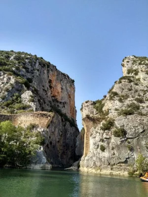
Foz de Lumbier was just amazing. Walk until the very end and then a bit of climbing is needed and you will see the ruins of a bridge (few remaining pillars are all that is left but still could be seen) that was built at the end of the Foz over the river. "Puente del diablo" it was called I think, and there was only a small sign for it with a bit of explanation of the guy who wanted to build that bridge. When I stood there it was windy asf and I couldn't imagine how someone in the 16/17th(?) century could make there a bridge without dying a thousand times...
 
Last edited:
Ideal sleeping bag liner whether we want to add a thermal plus to our bag, or if we want to use it alone to sleep in shelters or hostels. Thanks to its mummy shape, it adapts perfectly to our body.

€46,-
Last edited:
Walk until the very end and then a bit of climbing is needed and you will see the ruins of a bridge (few remaining pillars are all that is left but still could be seen) that was built at the end of the Foz over the river. "Puente del diablo" it was called I think, and there was only a small sign for it with a bit of explanation of the guy who wanted to build that bridge. When I stood there it was windy asf and I couldn't imagine how someone in the 16/17th(?) century could make there a bridge without dying a thousand times...
Thanks, @peterott. I had seen lots of references to the Puente del Diablo but hadn’t seen any bridge on any of the wikiloc tracks. NOW I get it! I see that there’s a legend attached to the bridge involving a beautiful ill damsel needing to get across the river to some magical waters. She made a pact with the devil, who built the bridge in exchange for her soul.

When you say “walk until the very end”, I think you are describing the walk starting in the town of Lumbier. Pilgrims walking from Sangüesa or Leyre will enter the gorge from Liedena. I THINK that the bridge itself is located before you enter the tunel to go through the gorge. But I have seen a lot of pictures of an information panel to alert you. In either case, based on your picture it would be easy to miss. Thanks again.

Actually, in 2018 I found less information about that bridge when looking for more info on the web as it was a stunning view.

I can't remember much, as said, I made a trip with a rental car. I parked the car at the "public Aparcamiento" and then easily started the walk along the River Irati into the gorge. At the "end of the gorge" you can see the highway A-21 and the ruins of the Roman Villa de Liédana laying on the other side of the Irati river. And just there was the well-hidden sign for the puente del diabolo which I saw by accident for climbing up some stones (pretty easy when it is dry, a "shall I really do it?" when it is wet) towards the right side of the bridge - when looking on the picture above. As it was dry, I went there of course :)

That was my starting point coming with the car from Lumbier, if it makes sense:

P.S.: If you are coming directly from "Liédana", then it seems that the bridge is at "the beginning of the gorge" I may guess.
 
Last edited:
Join the Camino cleanup. Logroño to Burgos May 2025 & Astorga to OCebreiro in June
Yes, the ruined bridge is on the southern end (Liedena/Jaca/Sanguesa) of the path through the Fox, just before the tunnel. It’s a short side trip from the main path, taking no more than a few minutes to access it. Definitely worth it if you have the time and don’t mind heights, though the chains make it very safe except in inclement weather.
 
Definitely worth it if you have the time and don’t mind heights, though the chains make it very safe except in inclement weather.
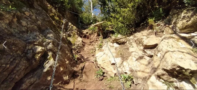
Thanks for this info, @Vacajoe. Just to be clear, the chains @Vacajoe is describing are not the same chains I was talking about that looked really scary. I was talking about chains on the “high route” that goes above the gorge, and they look like this:

IMG_1927.webp
 
€2,-/day will present your project to thousands of visitors each day. All interested in the Camino de Santiago.
Yes, these chains in your pic @peregrina2000 do not resemble the chains that are hammered in the stone when accessing one top side of the ruined bridge after walking through the gorge (direction from Lumbier to Liédana - on the exit towards Liédana).

That upper path looks pretty tough to hike. Did you try it? Holy moly... more like an alp/boulder trail.
 
That upper path looks pretty tough to hike. Did you try it?
I am just at the point that I have figured out which camino I want to walk next year. Now I have several months ahead of me hunting around to see what else lies within an easy walking detour of the official route. I had been as a tourist to Leyre and knew I wanted to walk there. When I learned that I could walk direct from the monastery of Leyre to the Foz without going through Sangüesa, I started searching for trails. The picture is from a track of the “upper trail” which takes you from Leyre, along a ridge above the Foz, and then into the town of Lumbier. It does look like it’s above my pay grade these days, but I like having information on all the options at the ready for when I finally walk. I will definitely report back, but it won’t be for many months if in fact I am lucky enough to walk this Camino!
 
I 20220706_175916.webp
I think this might be the terrain you are thinking of crossing? I took this photo in 2022 of an area which caused the area to be closed by a forest fire and I think this might be what you are thinking of traversing. Looks pretty rugged.
 
€2,-/day will present your project to thousands of visitors each day. All interested in the Camino de Santiago.
Yes, the chains at the destroyed bridge are horizontally placed and simply an extra handhold if the rocks are wet or your balance is iffy. The walkway is at a slight slope with a drop-off, but nowhere near the level of difficulty of that higher route chain area.
 
I think your journey was much easier because you avoided the road and its many bridges with no pedestrian lanes or shoulder. With the water that low, you could follow the old path versus the much longer winding roadway with its traffic. That road was hot and fairly busy, providing zero services and lots of reflected heat.
I didn't find it difficult, it's just a road. Weirdly, I don't remember much traffic, despite the motorway still being in construction. Perhaps it was sunday. It was very hot (and if I'm complaining, that means something) but I recall a fair amount of trees.
 
Train for your next Camino on California's Santa Catalina Island March 16-19
Thanks, @peterott. I had seen lots of references to the Puente del Diablo but hadn’t seen any bridge on any of the wikiloc tracks. NOW I get it! I see that there’s a legend attached to the bridge involving a beautiful ill damsel needing to get across the river to some magical waters. She made a pact with the devil, who built the bridge in exchange for her soul.

When you say “walk until the very end”, I think you are describing the walk starting in the town of Lumbier. Pilgrims walking from Sangüesa or Leyre will enter the gorge from Liedena. I THINK that the bridge itself is located before you enter the tunel to go through the gorge. But I have seen a lot of pictures of an information panel to alert you. In either case, based on your picture it would be easy to miss. Thanks again.
You can see by the picures on my wikiloc where I climbed to the ruined bridge at the start of the foz. The trail itself doesn't reach that far for some reason.

 
I didn't find it difficult, it's just a road. Weirdly, I don't remember much traffic, despite the motorway still being in construction. Perhaps it was sunday. It was very hot (and if I'm complaining, that means something) but I recall a fair amount of trees.
The road is not difficult, just dangerous as the small bridges over the inlets to the embalse are often blind curves with zero pedestrian space, so you are walking in a lane of what used to be the main highway. The new highway has taken much of that traffic since we walked, thankfully. Additionally, when the reservoir is extremely low, you can walk on the old path which is much shorter and straighter and not on tarmac.
 
One advantage I can see with the “north of the reservoir” route is that for those in a time crunch, I think it may be a day or maybe 2 shorter.

Caminka recommends Artieda to Leyre, which is 33 km:

This alternative does not go through Berdún, which @J Wilhaus likes, but it does remove the problem of what to do with a stage from Berdún to Leyre, which clocks in at almost 40.


The Berdún alternative on the northern side of the reservoir to Leyre involves leaving the Camino earlier, after Santa Cilia, and then having these stages (As per Alan Sykes).

Santa Cilia to Berdún (16 km)


and then Berdún to Leyre, which clocks in at almost 40.


Good to have choices!
 
Join the Camino cleanup. Logroño to Burgos May 2025 & Astorga to OCebreiro in June
Since this thread is about alternative walks on the Aragonese and seems to be attracting a few previous Aragonese walkers I'm going to throw out another alternative, a different start point.

Start from easy to get to Huesca on the Camino Catalan and walk for three days (Gronze, I took four) to connect to the Aragonese at Santa Cilia (or Arres or Puente de Reina de Jaca).

Here are things to see on or close to this stretch of the Camino Catalan:

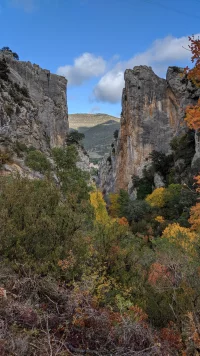
I think I have a better picture of the Foz de Escalete. The Catalan passes through this gap.
IMG_20191103_114058.webp
 
Last edited:
@Rick of Rick and Peg Oh no! More inspiration to ponder on. Researching this now.
This thread is really for the Aragonese variants but I'm stretching things by considering a Huesca start a variant. The full Catalan is much longer but I figured that if someone has already done the Aragonese from Somport and wants to do it again they may want to do the three day Huesca to Santa Cilia portion of the Catalan instead of the two day Somport-Jaca-Santa Cilia (or Arres).

There is a casa rural in La Peña Estación now (not shown in Gronze) that makes a three day trip practical now. I had to split things up for a four day walk: Huesca-Bolea-Sarsamarcuello-Ena-Puente de Reina de Jaca (Santa Cilia was closed in November and it was too dark and rainy to try for Arres).

See this post by @dick bird for information on the casa rural (and a restaurant) at La Peña Estación:
 
Last edited:
Holoholo automatically captures your footpaths, places, photos, and journals.

❓How to ask a question

How to post a new question on the Camino Forum.

Most read last week in this forum

I might not have the correct camino, someone will soon spot it! From the Hospitaleros Voluntarios newsletter. Please note, it is from the archive. Una Colaboración Hospitalidad en familia: Arrés...
Has anyone stayed here? Or have any information e.g. a WhatsApp number? I'm planning on walking the Aragones next year, and this looks like a good stop between Monreal and Puente de Reina. Any...

Featured threads

❓How to ask a question

How to post a new question on the Camino Forum.

Featured threads

Forum Rules

Forum Rules

Camino Updates on YouTube

Camino Conversations

Most downloaded Resources

This site is run by Ivar at

in Santiago de Compostela.
This site participates in the Amazon Affiliate program, designed to provide a means for Ivar to earn fees by linking to Amazon
Official Camino Passport (Credential) | 2024 Camino Guides
Back
Back
Top