• ⚠️ Emergency contact in Spain - Dial 112 and AlertCops app. More on this here.
  • Remove ads on the forum by becoming a donating member. More here.

Search 74,075 Camino Questions

Urdos to Somport Advice

Greetings pilgrims,

We are walking next September from Lourdes to Somport and would like to hear stories and adv ice about the section from Urdos to Somport, with the big incline. Is this route similar to St. Jean to Orisson? Are there services? What would be good for us to know? Thank you if you have something to post.
 
The 2024 Camino guides will be coming out little by little. Here is a collection of the ones that are out so far.
I also walked the Camino Aragones, starting at Lourdes, in 2018.... .

For reasons sufficient unto me I decided to skip that final push up to the Somport Pass. There was a bus from Urdos departing around 9:00 AM, passing first through Canfranc Estacion and then looping up and back to Somport, arriving at around 9:30 AM..... The "Oloron-Canfranc" Line, can probably find info somewhere on the 'net.... Nice bus, nice ride.... Don't recall the price, but it couldn't have been more than a euro or two.

The walk down from the Pass to Canfranc Estacion was astoundingly beautiful! Don't even think of missing it!
 
Last edited:
Greetings pilgrims,

We are walking next September from Lourdes to Somport and would like to hear stories and adv ice about the section from Urdos to Somport, with the big incline. Is this route similar to St. Jean to Orisson? Are there services? What would be good for us to know? Thank you if you have something to post.
Hola Professor’s, I’ll have some fresh info for you in about 10 days. It may be covered with snow though…😵‍💫
 
...and ship it to Santiago for storage. You pick it up once in Santiago. Service offered by Casa Ivar (we use DHL for transportation).
The only real resemblance to the climb from SJPDP is that it's steeply uphill. I much preferred the climb to the Somport pass, however. It's almost all on real trail, which (to my mind, at least) makes it more enjoyable than the slog on pavement on the Frances. It's also spectacularly beautiful, with the high peaks of the Pyrenees looming over you -- snow-covered in May when we walked, though probably not so in September. There are no services or places to stop, however, until you get to the pass, where there is an albergue. (There may also be hotels open in Candanchu, the ski resort within a kilometer of the pass, but they weren't open in May).

There also won't be a crowd walking with you. In fact, we saw absolutely no one once we left Urdos. Thus, pay close attention to the trail markers, as you won't be able to simply follow fellow travelers. We also relied on navigational guidance from mapy.cz, a wonderful free app. with all the caminos already on it -- meaning you don't have to download additional tracks.

From Urdos to the pass it's 13 kilometers, so that's about 3 kilometers less than the climb to the pass between SJPDP and Roncesvalles, and it's about 1000 meters of climbing instead of around 1200 meters of climbing on the Frances. If you don't want to stay at the pass, it's a further 7 steeply downhill (and still gorgeous) kilometers to Canfranc Estacion, with lots of services, and an additional 4 kilometers to Canfranc Pueblo, which boasts one of the great albergues on all the caminos.

I've walked a whole bunch of caminos, and I can't say there have been many other days that rivaled this walk.

Enjoy!
 
The albergue/store/cafe at the Somport Pass has intermittent open/close hours, so do not depend upon it unless you have confirmed in advance. Instead of staying there, Estacion is about 1-1.5 hours downhill from there and Pueblo another hour. It’s all downhill and worth the extreme walk to stay at the Pueblo donativo.
 
The only real resemblance to the climb from SJPDP is that it's steeply uphill. I much preferred the climb to the Somport pass, however. It's almost all on real trail, which (to my mind, at least) makes it more enjoyable than the slog on pavement on the Frances. It's also spectacularly beautiful, with the high peaks of the Pyrenees looming over you -- snow-covered in May when we walked, though probably not so in September. There are no services or places to stop, however, until you get to the pass, where there is an albergue. (There may also be hotels open in Candanchu, the ski resort within a kilometer of the pass, but they weren't open in May).

There also won't be a crowd walking with you. In fact, we saw absolutely no one once we left Urdos. Thus, pay close attention to the trail markers, as you won't be able to simply follow fellow travelers. We also relied on navigational guidance from mapy.cz, a wonderful free app. with all the caminos already on it -- meaning you don't have to download additional tracks.

From Urdos to the pass it's 13 kilometers, so that's about 3 kilometers less than the climb to the pass between SJPDP and Roncesvalles, and it's about 1000 meters of climbing instead of around 1200 meters of climbing on the Frances. If you don't want to stay at the pass, it's a further 7 steeply downhill (and still gorgeous) kilometers to Canfranc Estacion, with lots of services, and an additional 4 kilometers to Canfranc Pueblo, which boasts one of the great albergues on all the caminos.


Agree with most of above.. the profile is similar to the climb out of SJPdP, though it's a lot more rugged (and beautiful IMO) and there will certainly be no crowds. Don't count on the albergue/bar at the pass being open.. they suit themselves, and in September, Candanchu will be a ghost town too (maybe a bar open there to cater for maintenance staff). There's a small tienda in Urdos, stock up with food and water for about 5/6 hours of spectacular walking to get you up and over the pass and down into Canfranc Estacion, where there are plenty of services. Get provisions there if you're continuing down to the lovely albergue in Canfranc.
 
Ideal sleeping bag liner whether we want to add a thermal plus to our bag, or if we want to use it alone to sleep in shelters or hostels. Thanks to its mummy shape, it adapts perfectly to our body.

€46,-
I also walked the Camino Aragones, starting at Lourdes, in 2018.... .

For reasons sufficient unto me I decided to skip that final push up to the Somport Pass. There was a bus from Urdos departing around 9:00 AM, passing first through Canfranc Estacion and then looping up and back to Somport, arriving at around 9:30 AM..... The "Oloron-Canfranc" Line, can probably find info somewhere on the 'net.... Nice bus, nice ride.... Don't recall the price, but it couldn't have been more than a euro or two.

The walk down from the Pass to Canfranc Estacion was astoundingly beautiful! Don't even think of missing it!
It's the 550. Here's the schedule right now. https://transports.nouvelle-aquitai...CIAL Hiver-Fiche horaire Cars régionaux--.pdf
 
Greetings pilgrims,

We are walking next September from Lourdes to Somport and would like to hear stories and adv ice about the section from Urdos to Somport, with the big incline. Is this route similar to St. Jean to Orisson? Are there services? What would be good for us to know? Thank you if you have something to post.
We walked this two years after the walk from SJPdP to Roncevalles. They are both beautiful; do not miss it if the day is nice, as it was for us. They are both steep. Combining these two factors, take it slowly, drinking in the beauty. What is different is that peaks tower above you. It's stunning and unforgettable. And there were only a dozen of us who shared the albergue in Urdos walking to Somport. We had a communal meal together and were so excited. We were not disappointed. Bon chemin!
 
€2,-/day will present your project to thousands of visitors each day. All interested in the Camino de Santiago.
Greetings pilgrims,

We are walking next September from Lourdes to Somport and would like to hear stories and adv ice about the section from Urdos to Somport, with the big incline. Is this route similar to St. Jean to Orisson? Are there services? What would be good for us to know? Thank you if you have something to post.
It is a long haul up to the Somport Pass but quite manageable - I have walked it twice but it is probably more demanding than the St Jean Orisson stretch. I have walked up to Somport once following the path and then once along the road, which is easier in my opinion and also scenically superior. The path follows the river and in many places you cant see out above the trees and riverine growth.

Quite a few people take the bus option, but if you are able to do so, I would encourage you to walk it. Lourdes to Somport is a stunningly beautiful route. I could walk it again tomorrow if I got the opportunity.
 
Thank you Anthony. We have reservations in Urdos. Which albergue?
Can't say I remember other than it was on the main street over a deli. We were winging it, going against all advice regarding walking in France. We arrived, the door was open, we selected bunks. When the proprietor arrived, we were asked who we were, scolded for not calling in advance. But they let us stay. No harm, no foul. And they opened the deli below to us so we could get food for our communal cool. A memorable stay, as so many are on caminos.
 
Thank you Anthony. We have reservations in Urdos. Which albergue?
There's only one albergue in Urdos, so that's where you're probably staying: the gite comunale, called Le Gite Compostelle. If you write them a few days before, Eric, the manager, will alert you to ongoing road construction in the section between Accous and Borce, which will probably require you to take a bus for some or much of that stretch. Here's the email address: lecompostelle.urdos@live.fr

And if you haven't been following the parallel threads about the road construction, here's a link:
https://www.caminodesantiago.me/com...at-cette-eygun-diversion-via-n134-road.85709/
 
Fail to prepare? reduce your risk by buying this book full of practical info.
2nd ed.
Hello
Be careful, snow has fallen on the Pyrenees and the path between Urdos and Canfranc-Estacion is snowy.
I am providing the link to the webcams on the Spanish route N330a.
(See the last four from left to right. : Villanua / entrance to the tunnel at Canfranc / Lower crossing of Candanchu / Col du Somport).
Webcam Route DGT.ES
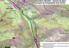
Before Urdos, I understand that a landslide has swept away part of the path at Matabou, in the commune of Cette-Eygun [halfway between Accous and Borce] and that the GR653 is closed at Cette-Eygun as work is now in progress there. In the meantime, a detour via the RN 134 has been set up. 1711664553177.jpeg
 
Last edited:
The 2024 Camino guides will be coming out little by little. Here is a collection of the ones that are out so far.
I have walked up to Somport once following the path and then once along the road, which is easier in my opinion and also scenically superior. The path follows the river and in many places you cant see out above the trees and riverine growth.
Today seems to be the day to start dreaming about Camino 2025. I am hoping to walk the Aragonés to Pamplona and then on the Viejo to Aguilar de Campóo. I have walked the Aragonés, but only from Somport. What I'm wondering is whether it's reasonable to think that I could walk from Urdos and beyond Somport to Canfranc on the first day.

I know there was serious damage and flooding this year, but I have done a fair amount of googling and think that the path from Urdos to Somport is open and manageable, although car traffic might be impossible. I'm wondering if @jennysa 's suggestion about sticking to the road is even possible now. I would appreciate any updates.

I'll be 75 but am a pretty good walker, so all advice and comparative experiences would be very much appreciated. I am happy to push myself but don't want to tackle something that doesn't make sense for me.
 
...and ship it to Santiago for storage. You pick it up once in Santiago. Service offered by Casa Ivar (we use DHL for transportation).
What I'm wondering is whether it's reasonable to think that I could walk from Urdos and beyond Somport to Canfranc on the first day.

I've walked it by both the path and the road.. Urdos to Canfranc, and personally, I found it easy enough. Once you get up to Somport it's all downhill anyway. Last time I did it was April of this year, by the road and with a little bit of a snow blizzard.
 
I’m not sure, Peregrina2000. My son in law Julien and I left Urda’s at first light last October 13. By the time we got to Candanchu I was pretty shot. I was 79. While drinking a beer there the friendly bar server said he got off work in half an hour and would gladly drop us off in Canfranc Pueblo on his way home. He refused any gas money. After spending the night in the delightful Elias Valiña Albergue we took the bus back up the mountain the next morning to continue our Camino. Beautiful mountains nice people. Buen Camino
 
...and ship it to Santiago for storage. You pick it up once in Santiago. Service offered by Casa Ivar (we use DHL for transportation).
Thanks, Flog. I thought I'd link in to the discussion of the September flooding and road closure. I know that Álvaro Lazaga walked after the rains, but he may be a bit more intrepid than I! I guess the thing to do is sit tight and wait to see what things look like in springtime.

Yes, fair enough. The path may still be waterlogged and treacherous in places next year, even in fair weather, but the road will be doable regardless (notwithstanding the washed away section that's under repair and may or may not be completed, but that's only a short section to circumvent).

In other words, it wouldn't thwart my plans to walk it next year, if that was my intention.
 
You might be interested to read a Spanish Pilgrims diary that I just posted over at
 
Today seems to be the day to start dreaming about Camino 2025. I am hoping to walk the Aragonés to Pamplona and then on the Viejo to Aguilar de Campóo. I have walked the Aragonés, but only from Somport. What I'm wondering is whether it's reasonable to think that I could walk from Urdos and beyond Somport to Canfranc on the first day.

I know there was serious damage and flooding this year, but I have done a fair amount of googling and think that the path from Urdos to Somport is open and manageable, although car traffic might be impossible. I'm wondering if @jennysa 's suggestion about sticking to the road is even possible now. I would appreciate any updates.

I'll be 75 but am a pretty good walker, so all advice and comparative experiences would be very much appreciated. I am happy to push myself but don't want to tackle something that doesn't make sense for me.
I don't know, Laurie. I'm with @JerryStroebele here. I was just shy of 74 when Kate and I walked the Urdos - Somport stretch last year and we were pretty toast when we got to the top -- even Kate, the marathon runner. It's all real trail, too, not like the climb out of SJPDP. We taxied down to Canfranc when we got to the top, then bussed back up the next morning to do the downhill leg. Which presented its own challenges.. Rocky and tough on the knees, and overall, I was certainly glad I hadn't attempted it the same day as the climb. But you're another order of beast.

Other than what I read here on the forum, I have no knowledge of current conditions.

Also sent you a pm.
 
Fail to prepare? reduce your risk by buying this book full of practical info.
2nd ed.
I appreciate we each have different levels of fitness, stamina (and stubborness, which I seem to have in abundance) and I agree, the trail is more difficult and slow underfoot than the road. The road is a good option too though, and is pretty much devoid of traffic, assuming it's back in use.

If you find yourself depleted of energy as you reach the Somport Pass, there is a bus from there down into Canfranc at around 4pm and you could roughly time your arrival at the pass to take it.. or not.
 
There are plenty of nice albergues on the Aragonés. From Pau on the Chemin Arles in France only a few. You would have to spend considerably more for gîtes, chambre d‘hotes or other private accommodations in a few towns but there you may experience some very fine French cuisine. Bon Chemin
 
It occurred to me that since I will be arriving in Spain, and had intended to get to Urdos from Canfranc by bus or cab, this whole plan depends on whether the road is open. Though I’ll walk back, if the road isn’t open I can’t get there.

Some googling brought up the very sad statistic that this road closure is costing Aragonese truckers about € 100,000 a day. They are re-routed through Irún, which adds a lot of time and money. A more recent article (behind a paywall but I can see some of it) reports that French authorities say that there will be a partial reopening at the end of January, but only one lane will be open and it will be for local traffic only. That sounds good for me, but not so good for the much more important traffic that will not be able to get through.
 
€2,-/day will present your project to thousands of visitors each day. All interested in the Camino de Santiago.
Some years ago I did that stage. I begun my Camino Aragones exactly at Urdos. Later I wrote a memories book for myself and friends. This is what I wrote about the stretch from Urdos to Somport. Hope it helps.


Urdos is a very small town with only two rows of houses along the road. It is located at the start of the mountain pass and seems the ideal place to attack Somport, since it is right there where the steepest climb begins. The taxi drops me off at the bus stop in the small town and I prepare to start walking. At that moment a pilgrim of about sixty years old arrives and asks me in French if I am going to start now. When I ask him yes, he offers to take a photo of me. I thank him for the photo (which he ultimately does not take, because he gets confused with the camera controls and I will only realise this at the end of the day) and I ask him if he would like a coffee in a nearby bar, since I have not had breakfast yet and I want to have something to drink. He accepts and we head to a bar that can be seen a few metres up. Now we speak in English, which we both master better than French, since the pilgrim in question is Dutch, his name is Jac and he has already been on the Camino through France for ten days. He plans to reach Pamplona this year. He has already done several Caminos, like me, and he is another addict. I tell him that I have a son living in Eindhoven. It takes him a while to understand the name of the city and suddenly a light comes on and he says:

- Ah, he lives in “aind-joven”!

It is obvious that my Dutch pronunciation is terrible...

We drink our coffee and separate. He wants to continue along the road to the tunnel entrance and I want to go the normal route, through the countryside. So Jac leaves a little earlier and I stay finishing the coffee and putting the first stamp on my credential.

On leaving the bar I cross the small village of typically Basque stone houses lined up on the sides of the road. The village has that clean and well-kept appearance that French villages have, however small they may be, and which is difficult to achieve in Spain. On leaving the village, always uphill on the road, I quickly locate the turnoff to the Camino but I get a surprise. There is a sign that says that due to landslides the path is temporarily diverted onto the road. Nothing prevents me from continuing along the path, but I don't want to take such a risk at the beginning, so I head up the road, which seems the safest option.

The first few kilometers of road are comfortable. The track is wide and has a shoulder that is easy to drive on and without excessive danger. There is a lot of traffic heading towards Spain, many Moroccans heading home and I suppose many weekend tourists; but hardly any cars go down towards France.

The Pyrenean landscape is spectacular. The road goes up between high green mountains. In this part of the Pyrenees the mountains are wilder and steeper than in the Roncesvalles part. There they are more rounded and here they have very sharp peaks, enormous cliffs and very steep slopes. The Camino goes up between two enormous mountains through which a fast-flowing stream runs.

I continue to climb and about a kilometer from Urdos, which is now very far down, there is an enormous crucified Christ, about three meters high, planted on the side of the road. Here when they say to put up a Cross, they don't mince words. It is very pretty and the figure is worthy of a church altar, but here it is, at the foot of the Camino so that we pilgrims can greet it.

A couple of kilometers further on the road narrows a lot and becomes very dangerous. It is sandwiched between a high cliff and a steep drop towards the river, which barely leaves room, not only for a shoulder, but for two cars to pass at the same time. There is a point where the car going up has to stop to make room for the one going down. I pass the area, about three hundred meters long, very carefully, quite quickly despite the slope and continually crossing sideways, always looking for the one with the best visibility at each bend.

After this very dangerous area the road widens a little again and continues to climb continuously, without stopping. At one point, I pass a house with a wooden fence made of ski boards.

After five kilometers on this route, we approach the mouth of the Somport Tunnel. It is time to leave the road and start to really climb the mountain on its slope. At a well-signposted point, a path leads off to the left that begins to climb the mountain with a very steep incline. This would also be a perfect point to start this stage, avoiding this first stretch of road. Looking back, you can still see the point where Urdos is located and the gorges that surround it. It is a beautiful view.

The first few meters of the path that goes up to Somport are very hard, but it soon becomes a bit easier and then I can start to really enjoy it.

It's really a wonder. A narrow path climbs through a dense forest. The stones and trees that line the path are completely covered in moss. With yesterday's rain everything is damp and the greens of the forest are resplendent. It looks like a fairy-tale path. The ground is covered with fallen leaves and every few hundred meters the path is crossed by streams that flow down swollen by the rain and that you have to cross by going from stone to stone.

It is a very wild path, with sometimes complicated steps and where from time to time there are areas that have collapsed towards the hillside due to the rain, thus narrowing the path even more. The path thus climbs tirelessly through the mountain with slopes that are sometimes very steep and that make me sweat profusely. It is a very hard climb, but beautiful. We are in the Pyrenees National Park, a protected area where there are bear reserves, which I hope not to see.

I have not seen any pilgrims since I left Urdos. The Camino here is not excessively signposted, but as it follows the same route as a French rural path, between the signs for one and the other, there is not much doubt: always uphill.

What you can see below is the river, which in this area seems to be dammed. The water is completely brown due to the dragging of soil from the rains that fell yesterday and it is very curious to look down and see a mass of brown water covering everything.

After five kilometers along this tiring and grateful path, the height begins to be noticeable and the trees begin to be scarcer. The path now goes through areas of grass where it often disappears, covered by grass, so you have to imagine where to go. It is not complicated and the signage in France, scarcer than in Spain and composed exclusively of small metal signs about five centimeters on each side with the GR indication attached to trees or posts, is sufficient and not as outrageous as ours.

Always going uphill you get to an area where huge masses of rock practically block the path, and you have no choice but to go up splashing through a small, very rocky stream that is swollen by yesterday's rains.

Finally, the path crosses a wide meadow to a road that you can see above and which you access by a steep slope. We are barely two kilometers from Somport and here on the road the signage is apparently non-existent. As I go up I see that there are people up there: a cyclist going down the road and two groups of pilgrims, each of whom takes a different direction. Perfect, let's see which is the good one… When I get to the road I see that in fact the signage does not exist. According to my perfect guide (the one I make myself) now I have to go down the road a little to go up the other side. So that is what I do, and I am right. A little further down there is one of the tiny signs on the path and further ahead one of the few arrows I have seen tells you to cross the road and take a path that, of course, starts to climb steeply.

So up again through some meadows where the path is barely visible, and crossing a couple of wooden bridges takes me to a beautiful little forest through which a stream runs thundering down from the top, forming beautiful waterfalls at certain points. Another stretch of elven forest that today's stage presents us with.

In this stretch I see that Jac, the Dutchman, is a little ahead of me. I don't make any effort to catch up with him, because the path, although beautiful, is very hard and steep with rocky areas where you have to be very careful to avoid slipping and twisting. So, each at his own pace, we reach the road again, now very close to the top of Somport.

Now you have to cross it and go through a huge parking lot, at the end of which you can see a path that goes up to some houses that you can see on high. It is the end of the climb. The houses you can see are already the Somport snow center.

But until you get there, the climb is one of the toughest of the day. A grass path with a steep slope that I climb little by little, panting and having to stop three times in just three hundred meters. A torture that ends when I reach the height of the houses, where you can already see the old customs that marks the border between Spain and France and a blue sign of the European community that indicates the entry into our country.

Well, Somport is already crowned. It has been thirteen kilometers of very hard, but beautiful climb from seven hundred meters in Urdos to the one thousand six hundred and forty where I am now. The height I am at is greater than that of Roncesvalles, since there the Lepoeder pass only reaches one thousand four hundred and fifty meters. It is one of the most beautiful climbs I have ever done. It was one o'clock, so it took me four hours to do thirteen kilometers, which means that the pace was about three kilometers per hour, a very slow pace that gives an idea of how hard the climb is.

As soon as I enter Spain there are three monuments to see: a small open-air chapel that is just an open shed for a Virgin of Pilar, which is at the top of the mountain; a curious monument to the pilgrim, made of iron and simple but very pretty; and the best and most Spanish of all the monuments: a bar to which I immediately head.
 
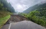
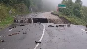
There was terrible flooding in the Aspe Valley between Urdos and Somport in September 2024 and the trail was allegedly closed at that time. I understand that a portion of the RN 134 between Oloron-Sainte-Marie (Pyrénées-Atlantiques) and Spain, at the Urdos exit was washed away, but that they hope to have minimum service at least resumed by January 2025. I would check with the local pilgrim associations/tourist offices to make sure the trail is safe. You walk on a very narrow ledge above the Aspe River for a fair distance just before and after Sarrance, which was bad enough when wet, so I would want local advice to make sure it is safe to walk before proceding as there had already been a mudslide before Urdos in the early part of 2024.

1730752515675.webp
 
Last edited:
Here's an article in the local newspaper on the road damage to the RN134 in the region https://www.nrpyrenees.fr/2024/10/0...ure-de-la-rn-134-en-janvier-2025-12235281.php. According to the tourist office in Bedous :

Bon à savoir​

A noter que suite aux intempéries de septembre dernier, les accès routiers sont rétablis pour accéder à tous les villages. La route RN134 reste en travaux au Sud d’Urdos et l’accès à l’Espagne est fermé (Col et tunnel)

Notre Bureau d’Information Touristique de Bedous est ouvert du lundi au samedi de 9h à 12h et de 14h à 18h. Toute notre équipe est mobilisée pour vous conseiller et vous aider à choisir vos activités et visites.

Le train et le bus circulent tous les jours en Vallée et desservent tous les villages situés sur la RN 134 (Sarrance, Bedous en train ; Accous, Eygun, Etsaut et Urdos en bus).

Le Transport A la Demande (sur réservation) vous permet de rejoindre les autres villages gratuitement certains jours de la semaine.

[English Translation via Deepl] :

Good to know

Following last September's bad weather, road access to all villages has been restored. The RN134 road to the south of Urdos remains under construction, and access to Spain is closed (pass and tunnel).

Our Tourist Information Office in Bedous is open Monday to Saturday, 9am to 12pm and 2pm to 6pm. Our entire team is on hand to advise you and help you choose your activities and visits.

Trains and buses run every day in the Valley, serving all the villages on the RN 134 (Sarrance, Bedous by train; Accous, Eygun, Etsaut and Urdos by bus).

Transport A la Demande (by reservation) allows you to reach other villages free of charge on certain days of the week.

UPDATE 11/5/2024 : According to an email I received today from the Relais du Bastet [Pilgrim lodging in Oloron} : the path from Urdos is not accessible now, but should be up and running again by spring.

1730753570961.webp
 
Last edited:
Get a spanish phone number with Airalo. eSim, so no physical SIM card. Easy to use app to add more funds if needed.
Thanks for this.. It was well documented at the time though.. and was discussed at some length on this forum.
I am referring to the recent September 2024 damage and not the damage earlier this year [? March 2024]. I just received an email today from the Relais du Bastet [Pilgrim lodging in Oloron} stating that the path [GR653] from Urdos to Somport is not accessible now, as it has been washed away/damaged in several places and needs to be rebuilt, but should be up and running again by spring. :)
 
Last edited:
Get a spanish phone number with Airalo. eSim, so no physical SIM card. Easy to use app to add more funds if needed.
On my recent Camino Frances I spoke to two separate pilgrims who had crossed to Somport. They had followed a GR path over the Pyrenees in a roundabout way which they said was very difficult and took 10 hours to reach Canfranc. Don't know any details.
 

❓How to ask a question

How to post a new question on the Camino Forum.

Most read last week in this forum

Hello all, just off the VDLP a couple of weeks ago and planning my next adventure. Here's what I have in mind; Camino Frances to Camino Arles and hoping to get to the Francigena through Nice and...

Featured threads

❓How to ask a question

How to post a new question on the Camino Forum.

Forum Rules

Forum Rules

Camino Updates on YouTube

Camino Conversations

Most downloaded Resources

Featured threads

This site is run by Ivar at

in Santiago de Compostela.
This site participates in the Amazon Affiliate program, designed to provide a means for Ivar to earn fees by linking to Amazon
Official Camino Passport (Credential) | 2024 Camino Guides
Back
Top