• Remove ads on the forum by becoming a donating member. More here.

Search 74,075 Camino Questions

GPS Devices

jfc731

New Member
Time of past OR future Camino
September 2024
I did a search typing GPS and read many informative posts.

It seems from what I have read that the route for the Camino Frances is well marked and I hope that is true.

QUESTION: Even so, in doing some research, I have wondered if my iPhone will do the trick using any number of apps or is having a hand-held GPS device, i.e., Garmin something necessary? Getting from Point A to Point B is good to know but what about elevation profile?

Any thoughts and/or advice you are willing to share is appreciated. Thank you.
 
Perfect memento/gift in a presentation box. Engraving available, 25 character max.
3rd Edition. Vital content training & pack guides avoid common mistakes, bed bugs etc
A dedicated GPS device is not essential for a Camino, as they are already very well marked and mapped. A phone has all you need.

Where a GPS device becomes useful is in adding extra detail at precise coordinates. If you wander off trail, you can find your way back to the original gpx path. Or if you wish to bushwhack and establish a new trail. The device then logs the new route.

If you can find a basic GPS device second hand or such to use for fun, all well and good. But you won't need to splash out big time for a Camino.

Like many of today's things to get, your imagined use is sometimes more than the device's application.
 
I carry a GPS, and will continue to do so. But I generally don't use it for navigation on the camino routes in Spain and Portugal. Modern phone apps are more than adequate for that, either general purpose navigation apps or specialist navigation apps. I do use my GPS on other pilgrimage routes for navigation, as well as for maintaining an accurate record of my walk.

My preferences are:
  • general purpose navigation - OSMAnd+ this is the paid for mapping app from Open Street Maps, but I also have the CNIG* (Spanish mapping agency} app and will use Google Maps to find places in towns and cities. I started using the OSMAnd+ app because I was able to download the mapping data and then use the app without having to use a mobile data connexion. These days I buy a mobile plan with a fair amount of data, so that is less important than it used to be. Note that there are many great navigation apps around today for outdoor enthusiasts, and it seems to me that getting something you find easy to use is probably more important than details about functionality, etc.
  • Camino specific apps - Wise Pilgrim and Gronze. There are several that I tried, and they all seem to do a pretty good job. The underlying functionality of these apps is pretty similar, but the Wise Pilgrim app worked best for me. There is an Android app for Gronze, but I found it just as easy to access in a web browser.
*edited to correct the acronym, thank you @Jeff Crawley
 
Last edited:
I did a search typing GPS and read many informative posts.

It seems from what I have read that the route for the Camino Frances is well marked and I hope that is true.

QUESTION: Even so, in doing some research, I have wondered if my iPhone will do the trick using any number of apps or is having a hand-held GPS device, i.e., Garmin something necessary? Getting from Point A to Point B is good to know but what about elevation profile?

Any thoughts and/or advice you are willing to share is appreciated. Thank you.
I’ve used the Buen Camino app. It is very good at GPS location and elevation. When in doubt, I did find myself using my phone as somewhat of a divining rod walking in many directions to see if I were in the right path :-)
 
A selection of Camino Jewellery
Some stages of the Camino have *multiples* path to the same destination. You need to have some type of guidebook or other information that describes each path and their advantages and disadvantages.

Some blindly follow the main path which is often the shortest along a major road, then complain about the traffic. By choosing the alternate paths carefully, it will yield a completely different peaceful experience, but you may need to walk a few extra kilometers.


-Paul
 
From a purely technical standpoint a dedicated GPSr is far better than a smartphone.

A DGPSr has one job and does it well. A smartphone has to share its resources.

I have a 10 year old Garmin which runs on 2 standard AA batteries giving me about 30 hours of use from a set of batteries - say 3 walking days. I load it with freely available Open Street Maps* which include contours - worldwide coverage is available. It weighs 150g and hangs happily on the shoulder strap of my pack. It uses both the American GPS and the Russian GLONASS satellite systems - newer versions use the EU Galileo system too

My Android smartphone will run numerous GPS and mapping apps but runs hot to the touch and will need to be charged every day as it was not designed to be a GPS running all of the time. You can extend the run time of your phone batteries by tweaking the settings - RTM. As far as I am aware smartphones will first use cell towers to locate you and then satellites kick in so it's not as good a system as far as accuracy is concerned if cell towers are sparse - remember the military use DGPSr not smartphone technology to target their munitions!

Having said all that you're not crossing the Gobi desert and unless you're like @dougfitz and I that like to play with recorded tracks there's no need to buy a device specifically for the Camino just "run what you brung" as they say at race meetings - you don't really need any kind of mapping, just follow the trail of toilet paper and you'll reach Santiago.

Either way have a great Camino. 🚶‍♂️

*The CNIG maps Doug refers to are works of art - (CNG just gives you the location of natural gas filling stations)
 
The are a number of options for the ‘map advanced’ people as previously mentioned.
However all I use is the markers in the Way, and the map function on the Camino Ninja app to see where I am. The Camino Ninja app opens up onto where you are at that very moment rather than the beginning of the route every time - as some other apps do. Today it tells me I am in Sydney and the red line of Camino Francés is a long way away. 😂😅
While a good guidebook will give you the most detailed info, the other Camino apps and Gronze give useful summaries of points is interest and alternate paths.
I have also used Ride with GPS to map my actual walk and record actual km’s.
Buen Camino
 
...and ship it to Santiago for storage. You pick it up once in Santiago. Service offered by Casa Ivar (we use DHL for transportation).
We found if we wandered off the CF accidently then locals would call out to us and indicate te way.
And one time when we wanted to walk off-trail and over a hill to answer nature's call with some privacy, all the pilgrims behind alerted us we were going te wrong way.
I did get lost for about 15 minutes in the dark early one morning, just had to backtrack to the last yellow arrow and then find the path forward.
 
The are a number of options for the ‘map advanced’ people as previously mentioned.
However all I use is the markers in the Way, and the map function on the Camino Ninja app to see where I am. The Camino Ninja app opens up onto where you are at that very moment rather than the beginning of the route every time - as some other apps do. Today it tells me I am in Sydney and the red line of Camino Francés is a long way away. 😂😅
While a good guidebook will give you the most detailed info, the other Camino apps and Gronze give useful summaries of points is interest and alternate paths.
I have also used Ride with GPS to map my actual walk and record actual km’s.
Buen Camino
I am very familiar with Ride GPS which I use regularly when out for a ride and knowing that it is an option on the Camino is a splendid suggestion. Thank you.
 
...and ship it to Santiago for storage. You pick it up once in Santiago. Service offered by Casa Ivar (we use DHL for transportation).
We found if we wandered off the CF accidently then locals would call out to us and indicate te way.
And one time when we wanted to walk off-trail and over a hill to answer nature's call with some privacy, all the pilgrims behind alerted us we were going te wrong way.
I did get lost for about 15 minutes in the dark early one morning, just had to backtrack to the last yellow arrow and then find the path forward.
Waiting for my walking buddy to get her act together one morning and I noticed an older gentleman dressed in a vest/undershirt puffing away on a cigarette as he stood in the window of his apartment. Every time a walker appeared he'd call out and gesture them to go to the right.
Well that's one way to start the day.
 
As far as I am aware smartphones will first use cell towers to locate you and then satellites kick in so it's not as good a system as far as accuracy is concerned if cell towers are sparse
What I've read about this is that absent cell towers smartphone GPS apps may take a while to accurately locate you when you start the app but then things are fine. If the start-up process can connect to cell towers it gets an approximate location quickly and this speeds up the rest of the process of getting an accurate location and the cell towers are not needed anymore as long as the satellite signals are good. I'm fine with being corrected if this is wrong.

Not too long ago I had our home surveyed for elevation. The surveyors used an expensive GPS device and recorded to a tenth of a foot (1.2 inches, 3 centimeters). It may have even been more precise but the data needed to be recorded as feet and tenths above sea level.

On the other side of accuracy was the time I was in a strange city and didn't have GPS reception for some reason. My location using just cell towers was a couple of blocks off. It wasn't too bad though as Maps showed the street names and layout and the street corners had signs with street names.
 
On the other side of accuracy was the time I was in a strange city and didn't have GPS reception for some reason. My location using just cell towers was a couple of blocks off. It wasn't too bad though as Maps showed the street names and layout and the street corners had signs with street names.
Dedicated GPS units don't perform well in cluttered urban environments with narrow streets and tall buildings. I think it is because the signals from the 'visible' satellites will get bounced around on the walls, and there will be multiple, indirect, paths rather than one single, simple, direct path from the satellite to the receiver. This already happens to some extent just in the atmosphere, but is aggravated in cities. It is possible that a smartphone using a combination of satellites, cell towers and wifi will work better in those environments because it is able to use those other sources of location information.
 
The 2024 Camino guides will be coming out little by little. Here is a collection of the ones that are out so far.
What I've read about this is that absent cell towers smartphone GPS apps may take a while to accurately locate you when you start the app but then things are fine. If the start-up process can connect to cell towers it gets an approximate location quickly and this speeds up the rest of the process of getting an accurate location and the cell towers are not needed anymore as long as the satellite signals are good. I'm fine with being corrected if this is wrong.

Not too long ago I had our home surveyed for elevation. The surveyors used an expensive GPS device and recorded to a tenth of a foot (1.2 inches, 3 centimeters). It may have even been more precise but the data needed to be recorded as feet and tenths above sea level.

On the other side of accuracy was the time I was in a strange city and didn't have GPS reception for some reason. My location using just cell towers was a couple of blocks off. It wasn't too bad though as Maps showed the street names and layout and the street corners had signs with street names.
I've switched off "location" on Google Maps - the monthly report kept showing me as spending an inordinate amount of time in my next door neighbour's house and never in my own . . .
 
Get a spanish phone number with Airalo. eSim, so no physical SIM card. Easy to use app to add more funds if needed.
It seems from what I have read that the route for the Camino Frances is well marked and I hope that is true.
It is true—mostly. When I was a hospitalero, I often walked from Villamayor de Monjardín to Los Arcos. On that route, there was a five-way intersection where the arrow post was placed in the ditch west of the road. Almost every time I passed, a car was parked hiding it from approaching pilgrims.

In Burgos, someone had painted a yellow arrow trying to divert pilgrims to his hotel.

Another place, I almost left the path because a correct arrow was painted on a hotel advertisement and I thought it might not be legitimate.

Near Estella, I took the wrong fork on an unmarked intersection and when I figured it out, I discovered that the arrow was placed about twenty meters after the fork!
 
I’ve used the Buen Camino app. It is very good at GPS location and elevation. When in doubt, I did find myself using my phone as somewhat of a divining rod walking in many directions to see if I were in the right path :-)
Darn straight!!!! For some reason these apps don't have the "cone of direction"... at least for the iPhone... whatever, walk a bit and see if you are still on "the line" (or dots). If not, retrace.
 
Darn straight!!!! For some reason these apps don't have the "cone of direction"... at least for the iPhone... whatever, walk a bit and see if you are still on "the line" (or dots). If not, retrace.
For all of those who continually ask me why in the world I continue to use wikiloc (not necessarily only you, @andycohn) , here's another reason. The blue cursor that you see when you are following a trail on wikiloc has a little arrow popping out of it that moves as you turn so that you can actually see which way you are headed. Sometimes it's a little harder to figure out but usually it works like a charm.
 
Ideal sleeping bag liner whether we want to add a thermal plus to our bag, or if we want to use it alone to sleep in shelters or hostels. Thanks to its mummy shape, it adapts perfectly to our body.

€46,-
For all of those who continually ask me why in the world I continue to use wikiloc (not necessarily only you, @andycohn) , here's another reason. The blue cursor that you see when you are following a trail on wikiloc has a little arrow popping out of it that moves as you turn so that you can actually see which way you are headed. Sometimes it's a little harder to figure out but usually it works like a charm.
Yah but that means you are following one perigrino's saved track, right? I don't share my Wikiloc tracks because that would violate my rule #1 on the camino... "Never follow another peregrino, they don't know where they are going either." If I had shared some of my tracks... oh man I'd feel so guilty.
 
I use a great device for my Caminos and it's called my eyes and these allow me to follow with ease the abundance of yellow arrows, shells etc. that mark the path of the Camino. :D
I have walked the Frances multiple times and have walked the Portugues and the Finisterre. I never needed an app to find my way. I never got lost. Never, ever. It's almost impossible to get lost.
On my recent Camino Frances this past summer it was comical the amount of pilgrims I saw noses buried in apps as they walked by, sometimes I could hear the apps human like voice directing them. What was funniest was that often time this was on places like the meseta where you are walking on the only road/path in the area and you could literally see the next 4-5 Camino markers in the distance. 😆
 
Get a spanish phone number with Airalo. eSim, so no physical SIM card. Easy to use app to add more funds if needed.
I use a great device for my Caminos and it's called my eyes and these allow me to follow with ease the abundance of yellow arrows, shells etc. that mark the path of the Camino. :D
I think you will find that most of the people who sing the praises of GPS tracks are those who walk caminos where there are no other people, very few arrows, and parts that are more remote than anything you will find on those caminos where your eyes can take care of you. Judgment isn’t really needed here.
 
I use a great device for my Caminos and it's called my eyes and these allow me to follow with ease the abundance of yellow arrows, shells etc. that mark the path of the Camino.
I am always amazed by the confidence expressed by those that have never missed seeing a waymark. I manage to do that, not regularly, but often enough to need some strategies beyond just retracing my steps to the last waymark that I saw. A GPS or GPS enable device with a decent map is a great aid at that point.
 
I think you will find that most of the people who sing the praises of GPS tracks are those who walk caminos where there are no other people, very few arrows, and parts that are more remote than anything you will find on those caminos where your eyes can take care of you. Judgment isn’t really needed here.
I believe the OP specifically inquired about the Camino Frances, which has so many markers one could hardly swing a dead cat without hitting one. :D
Not judging, just stating fact and the humour about pilgrims looking at app whilst they literally are walking past dozens of markers is just opinion based.
I simply believe, IMO, that worrying about getting lost while walking the Camino, specifically the Frances, is an unfounded worry and if one does get turned around or misses a marker, so what? How horrible can it be getting lost in beautiful northern Spain while walking the Camino?
 
The one from Galicia (the round) and the one from Castilla & Leon. Individually numbered and made by the same people that make the ones you see on your walk.
I believe the OP specifically inquired about the Camino Frances, which has so many markers one could hardly swing a dead cat without hitting one.
Sorry, I was obviously not focusing on the Francés. If you walk the Invierno, I think you will see an even greater abundance of arrows than on the Francés if you can believe it. I wouldn’t suggest that anyone needs a GPS on either of those routes, but there are lots of caminos where I would still be walking in circles without my trusty Wikiloc tracks.
 
How horrible can it be getting lost in beautiful northern Spain while walking the Camino?
That's a good question. I certainly don't fret as much as I did on my first camino, when it did concern me quite a lot more than it does today. I suspect that first timers in particular might be more concerned about losing their way. I know that on that first camino, when I made the mistake of following at GR sign shortly after Fonfria, I quickly realised that it was better to keep going down into the valley and find my way to Triacastella along the GR trail and local roads. The alternative of climbing back up to where I knew I had last seen a waymark was quite unappealing. I was able to use a GPS with detailed mapping from Open Street Maps to work out where I needed to head next. It had its moments, but it worked. I wouldn't have attempted that without having access to that mapping, even if it was on the tiny screen of my GPS.
 
The one from Galicia (the round) and the one from Castilla & Leon. Individually numbered and made by the same people that make the ones you see on your walk.
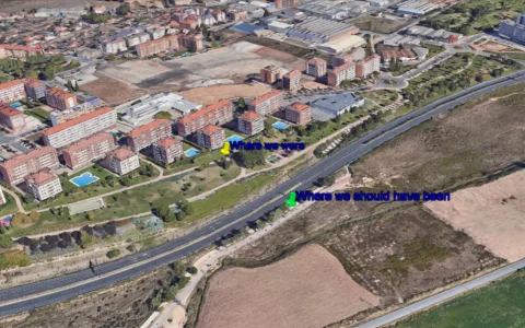
I'm genuinely surprised by tales of getting lost on the CF. We wandered of piste for a few hundred metres on my first Camino as we left Logroño - should have gone through the subway under the expressway but we were talking too much and ended up on a building site (apartments blocks on the north side of the expressway were just being built). Instantly realised what we'd done as there were no footprints in the mud in front of us.
This was 23 years ago and I'd never even seen a GPSr. How did we manage?
So you admit to getting lost, but are surprised when others share their stories of getting lost? I'm not sure I understand what point you are trying to make here. It always seemed to me that this is one point over which members have a fundamental divide. Those that have never missed a way mark and never found themselves lost, and who seem to lack the imagination to understand that it is possible. And then there are those who have gotten lost, and know only too well how easy that might be. @Jeff Crawley, I must now contemplate a third category, those that have gotten lost but nonetheless deny that it is possible :}
 
So you admit to getting lost, but are surprised when others share their stories of getting lost? I'm not sure I understand what point you are trying to make here. It always seemed to me that this is one point over which members have a fundamental divide. Those that have never missed a way mark and never found themselves lost, and who seem to lack the imagination to understand that it is possible. And then there are those who have gotten lost, and know only too well how easy that might be. @Jeff Crawley, I must now contemplate a third category, those that have gotten lost but nonetheless deny that it is possible :}
I wasn't trying to be haughty, Doug. Like you I carry a dedicated GPSr for recording rather than to find my way, certainly on something that I consider to be fairly straightforward such as the CF.
It's been a handful of years since I last walked the CF but I seem to remember that there was an abundance of waymarkers certainly compared to the way it was marked out in 2001.
You'll note that I said we went "off piste", I didn't say we got lost. For the record it was here and the waymarker had been obliterate by the work on those blocks of apartments that were under construction in 2001:

logrono.webp

Hardly "lost in the wilderness" were we?

Take care,

J
 
Ideal sleeping bag liner whether we want to add a thermal plus to our bag, or if we want to use it alone to sleep in shelters or hostels. Thanks to its mummy shape, it adapts perfectly to our body.

€46,-
That doesn't happen when I use the Wise Pilgrim or Buen Camino apps.
Perhaps not but I was using Buen Camino and would set up my own waypoints using an avaliable option to do so (that was if "my"stage was different fron a given "standard " stage). So it was mainly an extra click in the morning to get me to the right map
 
I did a search typing GPS and read many informative posts.

It seems from what I have read that the route for the Camino Frances is well marked and I hope that is true.

QUESTION: Even so, in doing some research, I have wondered if my iPhone will do the trick using any number of apps or is having a hand-held GPS device, i.e., Garmin something necessary? Getting from Point A to Point B is good to know but what about elevation profile?

Any thoughts and/or advice you are willing to share is appreciated. Thank you.
I use a garmin watch. Download the gpx files online and works well, almost 99%.

Surely you can use any apps on your phone, which also provides elevation maps. Even books are good too.
 

❓How to ask a question

How to post a new question on the Camino Forum.

Most read last week in this forum

Hello Folks, Just found this on aliexpress : www.aliexpress.com/e/_DEy0Tv3 Price is decent but I worry aboout quality. Anyone have bought something similar? Thanks!
While shopping this morning I noticed that Aldi's ski clothing special buys will include merino base layers, and zip and roll neck tops. Due in store this Thursday. I bought a merino top from them...
I recently travelled to Thailand where I did a lot of walking wearing my new Keen Anatomic Fit shoes. These shoes have a wide toe area in front. They are also a size larger for the purpose of...

Featured threads

❓How to ask a question

How to post a new question on the Camino Forum.

Featured threads

Forum Rules

Forum Rules

Camino Updates on YouTube

Camino Conversations

Most downloaded Resources

This site is run by Ivar at

in Santiago de Compostela.
This site participates in the Amazon Affiliate program, designed to provide a means for Ivar to earn fees by linking to Amazon
Official Camino Passport (Credential) | 2024 Camino Guides
Back
Back
Top