Search 74,075 Camino Questions

Do you have a method or list of towns and distances?

Time of past OR future Camino
April 2025 CF
Hello,
My question is: For those of you who do a little bit of planning, do you use some sort of list of all towns and distances to have a general idea what towns you will pass through? (More than a guide book) I have a list, and it's OK, but I'm guessing there's a better method.

I am hoping to walk most of my April Camino Francés without reservations (except the usual bottlenecks and maybe a few special albergues). I got a list (I think here on the forum) of All towns and distances along the Francés, and I've been jotting down notes on the list. It's been handy to figure out how many days it might take to get to certain areas. Or for example, it's how I figured out which towns I might be near when on Easter and other holidays.

I suppose one could use a guide book for this, since it shows distances, but i like having the towns all displayed on one long list, instead of flipping through pages. I'll use the guide book and apps as well, but they don't seem to be great for adding notes and getting an idea of my overall plan.

Here's another example of where my list might come in handy: If I have heard so many wonderful things about Albergue XYZ, I may want to reserve that one, so my list can help me figure out my arrival date.

So my main question is, do you use something similar or have any advice? Thanks!
 
The one from Galicia (the round) and the one from Castilla & Leon. Individually numbered and made by the same people that make the ones you see on your walk.
The Godesalco stage planner has all the towns in one long list:


I use it along with the Wise Pilgrim and Buen Camino apps, and the Gronze website.


These are worth exploring


And


Many of us use the latter for planning

Easter Sunday 2025 is April 20th. The week before and after will be particularly busy.

Google Chrome and other browsers will machine translate these into English (and indeed many other languages).
 
€2,-/day will present your project to thousands of visitors each day. All interested in the Camino de Santiago.
What @trecile said - Godesalco is awesome for planning because it gives you immediate options on how far you want\can walk and calculates the distances and days (you can even plug in rest days if so desire)
as per @donalomahony - Gronze will give you a more comprehensive list of accommodations open "currently". Its in Spanish so have to use GoogleTranslate if not proficient in that language
Combined (and with other sources mentioned) you can easily do your homework to your heart's desire
Good luck and Buen Camino!
 
Ah yes, that Planificador is cool! thanks to you all! Wow following through the Godesalco steps really provides some nice info in excel or pdf format in the end. If only I had used "stage planner" in my forum search. I was using other terms that were not getting me good results.
 
The 2024 Camino guides will be coming out little by little. Here is a collection of the ones that are out so far.
I will often use Gronze, apps, guidebooks, etc. and figure out what I think my probable stages are. Then I create a Google Doc with those stages. I fill that with information from all those sources, from Forum posts, etc. and that's how I do my planning.
 
The godelsaco planner is aweseome, but there is one downside: it does only provide one "main" path to plan and doesnt offer any alternative routes. Buen camino app is a bit better in that regard, at least in daily usage on the trail. I find planning multiple days in it a bit tiresome.
Then there is the almighty www.gronze.com which has propably the most information in it, but you can only extract distances between towns from the maps and not every distance is in there.

Imho there is no single best option. For rough planning at home i like to use godelsaco. For more in depth planning i use gronze. For use on trail i use buen camino or ninja.
 
So my main question is, do you use something similar or have any advice? Thanks!
I had made a list in google maps with all the as "best option" marked Albergues of this forum. The map is then saved as file on my phone to access it without having a decent connection.
On top of this in the map are all POI and viewpoints I wanted to see myself.
At each evening I opened maps and try to memorize the points and Albergues of the next day.

Worked pretty well for me on the CF and CP.
 
Get a spanish phone number with Airalo. eSim, so no physical SIM card. Easy to use app to add more funds if needed.
I will often use Gronze, apps, guidebooks, etc. and figure out what I think my probable stages are. Then I create a Google Doc with those stages. I fill that with information from all those sources, from Forum posts, etc. and that's how I do my planning.
I’m similar, but more analogue.

I literally draw the route to scale on the left page of my journals, listing the places I’ll pass en-route. I know I’ll cover roughly a page and a half in a day’s walking so it helps me visualise where I should be looking to stay. I use the usual sources as @David Tallan and others to add notes and then en-route add sellos or other ephemera or notes as I pass.
 
Another vote for Godesalco and Gronze. I used Godesalco to plan out 3 or 4 days into the future based on what distances I felt comfortable with, and gronze.com to explore lodging options at the potential stopping points. The caminoapp.com website Wisepilgrim mentioned sounds interesting and I'll definitely check it out!
 
Ideal sleeping bag liner whether we want to add a thermal plus to our bag, or if we want to use it alone to sleep in shelters or hostels. Thanks to its mummy shape, it adapts perfectly to our body.

€46,-
Hello,
My question is: For those of you who do a little bit of planning, do you use some sort of list of all towns and distances to have a general idea what towns you will pass through? (More than a guide book) I have a list, and it's OK, but I'm guessing there's a better method.

I am hoping to walk most of my April Camino Francés without reservations (except the usual bottlenecks and maybe a few special albergues). I got a list (I think here on the forum) of All towns and distances along the Francés, and I've been jotting down notes on the list. It's been handy to figure out how many days it might take to get to certain areas. Or for example, it's how I figured out which towns I might be near when on Easter and other holidays.

I suppose one could use a guide book for this, since it shows distances, but i like having the towns all displayed on one long list, instead of flipping through pages. I'll use the guide book and apps as well, but they don't seem to be great for adding notes and getting an idea of my overall plan.

Here's another example of where my list might come in handy: If I have heard so many wonderful things about Albergue XYZ, I may want to reserve that one, so my list can help me figure out my arrival date.

So my main question is, do you use something similar or have any advice? Thanks!
I like 2 apps that give you not only the main stages but every town between: CaminoTool and CaminoNinja. I think Camino Ninja is especially good because it shows where bars restaurants and albergues and hotels/hostals are along the route. Both apps are good to keep you on the right track too….the main trails and any complimentary routes available.
 
I’m similar, but more analogue.

I literally draw the route to scale on the left page of my journals, listing the places I’ll pass en-route. I know I’ll cover roughly a page and a half in a day’s walking so it helps me visualise where I should be looking to stay. I use the usual sources as @David Tallan and others to add notes and then en-route add sellos or other ephemera or notes as I pass.
That sounds like something fun to look back at when you’re done. Kind of a pilgrims passport but more. Share a picture of a page if you care to.
 
3rd Edition. Vital content training & pack guides avoid common mistakes, bed bugs etc
Hello,
My question is: For those of you who do a little bit of planning, do you use some sort of list of all towns and distances to have a general idea what towns you will pass through? (More than a guide book) I have a list, and it's OK, but I'm guessing there's a better method.

I am hoping to walk most of my April Camino Francés without reservations (except the usual bottlenecks and maybe a few special albergues). I got a list (I think here on the forum) of All towns and distances along the Francés, and I've been jotting down notes on the list. It's been handy to figure out how many days it might take to get to certain areas. Or for example, it's how I figured out which towns I might be near when on Easter and other holidays.

I suppose one could use a guide book for this, since it shows distances, but i like having the towns all displayed on one long list, instead of flipping through pages. I'll use the guide book and apps as well, but they don't seem to be great for adding notes and getting an idea of my overall plan.

Here's another example of where my list might come in handy: If I have heard so many wonderful things about Albergue XYZ, I may want to reserve that one, so my list can help me figure out my arrival date.

So my main question is, do you use something similar or have any advice? Thanks!
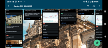
Trello. I love this app/website for Camino planning. You can add anything to it. I create lists for each town including distances between then. Cards for each accommodation option, shops, bars, must-do attractions, maps/elevations, interesting bits of history etc you can add labels as well. And it is all easy to shift around. I'm currently planning a Camino Mixto of Madrid/Salvador/Primitivo. It's a DIY guidebook.1000039515.png
 
Transport luggage-passengers.
From airports to SJPP
Luggage from SJPP to Roncevalles
Get a spanish phone number with Airalo. eSim, so no physical SIM card. Easy to use app to add more funds if needed.
The 2024 Camino guides will be coming out little by little. Here is a collection of the ones that are out so far.
I had made a list in google maps with all the as "best option" marked Albergues of this forum.
Yes indeed the LIST function is most useful and can be made public for other people, but the extension is the DIRECTIONS function (sat nav) where you simply add the places in the LIST to the DIRECTIONS for your daily plan then press SAVE TO PHONE and it guides you every meter of YOUR Camino, even updating your arrival time at each STEP along the way (maximum of 10).
 
add the places in the LIST
I hasten to add that this is not INSTEAD OF gronze and Brierley etc but AS WELL AS.

Horses for courses 🏇 and gronze, Brierley etc are the experts on the particular accommodation etc pilgrims need and it is only after that has been established for a particular daily leg that google takes over on the NAVIGATION side.

Google simply defers to the so called Gatekeepers like booking.com, travago etc
 
I like 2 apps that give you not only the main stages but every town between: CaminoTool and CaminoNinja. I think Camino Ninja is especially good because it shows where bars restaurants and albergues and hotels/hostals are along the route. Both apps are good to keep you on the right track too….the main trails and any complimentary routes available.
Buen Camino and Wise Pilgrim also provide these.
 
...and ship it to Santiago for storage. You pick it up once in Santiago. Service offered by Casa Ivar (we use DHL for transportation).

❓How to ask a question

How to post a new question on the Camino Forum.

Most read last week in this forum

It's now seven weeks since I returned from doing he Frances and what a wonderful 40 days it was. I'm sure there are possible pilgrims out there that worry that they may be too old to walk the...
I stayed at the Orreage/Roncesvalles albergue back in 2021 and I remember hearing beautiful Gregorian chanting upon waking up. I'm not able to find anything online about the monks there (such as...
After walking the very quiet VDLP this year I'm planning on returning to the crowded CF next spring. I know May is a very popular time to leave SJPDP, and in previous years mid-May was the worst...
On Thursday 5/1st first I plan to arrive to SJPDP by around 15:00 hr, do I have time to walk to pilgrim credential office, and go buy hiking sticks before they close? I want to start walking to...
If you plan a pilgrimage on the Camino Francés during the winter you need to keep an eye on this website http://www.aprinca.com/alberguesinvierno/ to get up to date info about closed/open...
Hi! I'm planning to do the Camino Francés in a month starting January 22nd from SJPDP to Santiago. Can you tell me the alternative routes and albergues that are interesting and that I must...

Featured threads

❓How to ask a question

How to post a new question on the Camino Forum.

Forum Rules

Forum Rules

Camino Updates on YouTube

Camino Conversations

Most downloaded Resources

Featured threads

This site is run by Ivar at

in Santiago de Compostela.
This site participates in the Amazon Affiliate program, designed to provide a means for Ivar to earn fees by linking to Amazon
Official Camino Passport (Credential) | 2024 Camino Guides
Back
Top