• Remove ads on the forum by becoming a donating member. More here.

Search 74,075 Camino Questions

Affordable "virtual Camino" app with Street View?

Prentiss Riddle

Aprendiz de todo, maestro de nada
Time of past OR future Camino
Português and/or Francés in 2023
I know that this is a perennial topic, but technology changes and some of the threads of the past no longer have current information.

My question: Is there a reasonably priced way to do a "virtual Camino" where I record pedometer steps from my walks at home and can see my Camino progress on Google Street View?

Or maybe I'm asking the question wrong. Are there generic GPS apps that let you walk a track "virtually" and have Street View support?

What I've found so far:

I've been using the World Walking app and it's okay, I guess, but it just shows my progress on a map (not even a good one) and has a handful of Wikipedia-like articles as local color. No Street View, not even photos.

There's a site and app called "The Conqueror" with a virtual Camino that's apparently like what I have in mind, but it's expensive - $35, much of which goes toward a medal they send you when you complete it (more if you also want a t-shirt). I don't mind paying a few bucks for an app but I have no interest in a medal.

Recently I learned of the site Walking 4 Fun which has a very 90's feel (no app, and heavy use of Comic Sans!). It has no Street View but does show crowdsourced photos from the area where you stop.

So... is there a way to do what I'm looking for?

Thanks!
 
Join the Camino cleanup. Logroño to Burgos May 2025 & Astorga to OCebreiro in June
I know that this is a perennial topic, but technology changes and some of the threads of the past no longer have current information.

My question: Is there a reasonably priced way to do a "virtual Camino" where I record pedometer steps from my walks at home and can see my Camino progress on Google Street View?

Or maybe I'm asking the question wrong. Are there generic GPS apps that let you walk a track "virtually" and have Street View support?

What I've found so far:

I've been using the World Walking app and it's okay, I guess, but it just shows my progress on a map (not even a good one) and has a handful of Wikipedia-like articles as local color. No Street View, not even photos.

There's a site and app called "The Conqueror" with a virtual Camino that's apparently like what I have in mind, but it's expensive - $35, much of which goes toward a medal they send you when you complete it (more if you also want a t-shirt). I don't mind paying a few bucks for an app but I have no interest in a medal.

Recently I learned of the site Walking 4 Fun which has a very 90's feel (no app, and heavy use of Comic Sans!). It has no Street View but does show crowdsourced photos from the area where you stop.

So... is there a way to do what I'm looking for?

Thanks!


Hi! I'm currently using "The Conqueror" app to walk a virtual Camino with a few friends. I agree that it's expensive and I too have no interest in the medal. About 3 months ago, I did the Hadrian's Wall walk to see what the app was like. I actually stopped logging miles about 10 miles from the end because I didn't want to get the medal in the mail.

5 days ago, some friends and I decided to use the app for the Camino de Santiago walk. It's the best app I've been able to find. Here are my thoughts...

After using the app for the Hadrian's Wall walk, I was not super impressed. The app was not very intuitive and the street view is decent. Although, there were a few places I landed that had some pretty cool views like George Washington's ancestral home and seeing the wall in a number of places was fun. I didn't know what Hadrian's Wall was until I did the walk so it was fun to learn a bit of history.

When I saw that "The Conqueror" had added a Camino walk, I immediately told myself I would never do that! How in the world, after actually walking it, would I do it on some app! Yeah, a little snobby, I know. But, after talking with two friends, who are walking the Via di Francesco with me next fall (fingers crossed), we decided to give the app a go. So far, it's been very fun! We started with a kickoff time on my porch with tapas and Ramon Bilbao wine. While we were sitting there, a good friend and fellow Camino pilgrim "happen" to walk by. He joined us and shared tapas, wine, and stories from his Camino which was very special as my two friends have not yet walked it. Before he left, he prayed a Pilgrim blessing over us. Hmm...it seems the Camino provides in Portland, Oregon too!! As I walk, I carry my pilgrim shell and a rock for when I arrive at "Cruz de Ferro". I look at my Brierly's guide book to see where I would be if I were actually in Spain and reminisce over photos and my journal from my previous trips on the Camino. It's actually been really fun so far! I would recommend it.

Here are my thoughts on the app. While the app is not intuitive, at least to me, their customer service is incredible!! I asked multiple questions on their support email and had answers within 10 minutes. As I use the app, it becomes easier to use. I would say it's not ideal but it's the best I have found on the market.

Since starting, each of us has had someone who wanted to join us. So, we now have seven in our community and a few more considering joining. It's been fun to share communication and photos in the app with my group of friends each day.

If you want to follow our journey, I have a Facebook with the user name, Caminoclosner. Our community on The Conqueror is "Ramon Bilbao Babes." Let me know if you end up doing this app. I'd love to follow your journey!
 
The 2024 Camino guides will be coming out little by little. Here is a collection of the ones that are out so far.
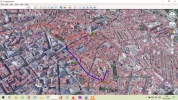
Along with a couple of friends I'm recording my progress on W4F but also keeping track on Google Earth.
Currently we are enjoying the flesh-pots of Leon:

1601813260721.webp

With "Terrain" switched on you can wend your way along the Camino using the "Play Tour" icon.
Be careful with the speed at which you view it, it can be quite nausea inducing if too fast!
 
Just today I finished the Arizona Trail (AZT) on Walking4fun, 813 miles. I'm using the free version, been walking locally since early June. Every night I plug in my steps and get pictures (every .3 mi) of what I covered that day. It works for me.

I'm about to embark on the Camino Frances for my next one. As I'm moving into colder weather, that will warm my heart!

Blessings, Priscilla
 
I know that this is a perennial topic, but technology changes and some of the threads of the past no longer have current information.

My question: Is there a reasonably priced way to do a "virtual Camino" where I record pedometer steps from my walks at home and can see my Camino progress on Google Street View?

Or maybe I'm asking the question wrong. Are there generic GPS apps that let you walk a track "virtually" and have Street View support?

What I've found so far:

I've been using the World Walking app and it's okay, I guess, but it just shows my progress on a map (not even a good one) and has a handful of Wikipedia-like articles as local color. No Street View, not even photos.

There's a site and app called "The Conqueror" with a virtual Camino that's apparently like what I have in mind, but it's expensive - $35, much of which goes toward a medal they send you when you complete it (more if you also want a t-shirt). I don't mind paying a few bucks for an app but I have no interest in a medal.

Recently I learned of the site Walking 4 Fun which has a very 90's feel (no app, and heavy use of Comic Sans!). It has no Street View but does show crowdsourced photos from the area where you stop.

So... is there a way to do what I'm looking for?

Thanks!
I use Relive, allows you to include pictures etc.
 
The one from Galicia (the round) and the one from Castilla & Leon. Individually numbered and made by the same people that make the ones you see on your walk.
I know that this is a perennial topic, but technology changes and some of the threads of the past no longer have current information.

My question: Is there a reasonably priced way to do a "virtual Camino" where I record pedometer steps from my walks at home and can see my Camino progress on Google Street View?

Or maybe I'm asking the question wrong. Are there generic GPS apps that let you walk a track "virtually" and have Street View support?

What I've found so far:

I've been using the World Walking app and it's okay, I guess, but it just shows my progress on a map (not even a good one) and has a handful of Wikipedia-like articles as local color. No Street View, not even photos.

There's a site and app called "The Conqueror" with a virtual Camino that's apparently like what I have in mind, but it's expensive - $35, much of which goes toward a medal they send you when you complete it (more if you also want a t-shirt). I don't mind paying a few bucks for an app but I have no interest in a medal.

Recently I learned of the site Walking 4 Fun which has a very 90's feel (no app, and heavy use of Comic Sans!). It has no Street View but does show crowdsourced photos from the area where you stop.

So... is there a way to do what I'm looking for?

Thanks!
Hi, I have used the conqueror app. It is good and you follow your progress right along the Camino. The also often offer discounts via Facebook.
 
Along with a couple of friends I'm recording my progress on W4F but also keeping track on Google Earth.
Currently we are enjoying the flesh-pots of Leon:

View attachment 84394

With "Terrain" switched on you can wend your way along the Camino using the "Play Tour" icon.
Be careful with the speed at which you view it, it can be quite nausea inducing if too fast!


I didn’t know about Terrain! I’m going to explore that tomorrow. Thanks for the tip! I walked 8 miles today in the Columbia River Gorge in Washington state, United States. The Cape Horn trail felt so much like walking down the Pyranees to Roncesvalles which would have been where I was in Spain today. So grateful for virtual walks and all the technology we have today to enjoy it! Buen Virtual Camino!
 
€2,-/day will present your project to thousands of visitors each day. All interested in the Camino de Santiago.
I know that this is a perennial topic, but technology changes and some of the threads of the past no longer have current information.

My question: Is there a reasonably priced way to do a "virtual Camino" where I record pedometer steps from my walks at home and can see my Camino progress on Google Street View?

Or maybe I'm asking the question wrong. Are there generic GPS apps that let you walk a track "virtually" and have Street View support?

What I've found so far:

I've been using the World Walking app and it's okay, I guess, but it just shows my progress on a map (not even a good one) and has a handful of Wikipedia-like articles as local color. No Street View, not even photos.

There's a site and app called "The Conqueror" with a virtual Camino that's apparently like what I have in mind, but it's expensive - $35, much of which goes toward a medal they send you when you complete it (more if you also want a t-shirt). I don't mind paying a few bucks for an app but I have no interest in a medal.

Recently I learned of the site Walking 4 Fun which has a very 90's feel (no app, and heavy use of Comic Sans!). It has no Street View but does show crowdsourced photos from the area where you stop.

So... is there a way to do what I'm looking for?

Thanks!

Hello Prentiss Riddle,
I started virtual walking about five years ago on the Global Corporate Challenge which was through my work, Corporate, eh. It was fun with a work team & an online community. Much diminished now but I've made global friends from the online community & we're still walking together though not always with GC.
This year I walked the Great Ocean Rd with the Conqueror website using street view. Not much fun but passable. I got the medal but haven't walked with them again, not enough involvement.
Through the Camino Forum I heard of Walking4Fun & now I've walked the Camino Frances, which I haven't done IRL. That was a marvellous experience as others from the Forum walked the trail too, all of us at different stages, communicating through the Forum. Reference @Jeff Crawley who answered you, he called it Band of Trudgers. Some of us have finished CF & moved on to other trails with W4F, we drop back in to catch up with the others. I'm walking the Arizona Trail atm. The best thing to me about this site is the multitude of photos that Ryan Carpenter includes with each day's walk. He has walked each of these walks himself & takes a photo about every .3-.4km along the trail.
My work is now doing walks through World Walking, the first had street view but not the second. Not as engaging as W4F though, even with some team interaction to add interest.
My preference is W4F for interest & engagement. I don't have time to sit clicking ahead in street view so all Ryan's photos are great. The only apps/sites that cost money were the Global Challenge, sponsored by my work for a few years, & the Conqueror sites.
I hope you find the style that suits you. Buen Camino!
@Jeff Crawley, I hadn't seen the Terrain addition so will have to look. Thanks for the info.
 
Last edited:
Hi! I'm currently using "The Conqueror" app to walk a virtual Camino with a few friends. I agree that it's expensive and I too have no interest in the medal. About 3 months ago, I did the Hadrian's Wall walk to see what the app was like. I actually stopped logging miles about 10 miles from the end because I didn't want to get the medal in the mail.

5 days ago, some friends and I decided to use the app for the Camino de Santiago walk. It's the best app I've been able to find. Here are my thoughts...

After using the app for the Hadrian's Wall walk, I was not super impressed. The app was not very intuitive and the street view is decent. Although, there were a few places I landed that had some pretty cool views like George Washington's ancestral home and seeing the wall in a number of places was fun. I didn't know what Hadrian's Wall was until I did the walk so it was fun to learn a bit of history.

When I saw that "The Conqueror" had added a Camino walk, I immediately told myself I would never do that! How in the world, after actually walking it, would I do it on some app! Yeah, a little snobby, I know. But, after talking with two friends, who are walking the Via di Francesco with me next fall (fingers crossed), we decided to give the app a go. So far, it's been very fun! We started with a kickoff time on my porch with tapas and Ramon Bilbao wine. While we were sitting there, a good friend and fellow Camino pilgrim "happen" to walk by. He joined us and shared tapas, wine, and stories from his Camino which was very special as my two friends have not yet walked it. Before he left, he prayed a Pilgrim blessing over us. Hmm...it seems the Camino provides in Portland, Oregon too!! As I walk, I carry my pilgrim shell and a rock for when I arrive at "Cruz de Ferro". I look at my Brierly's guide book to see where I would be if I were actually in Spain and reminisce over photos and my journal from my previous trips on the Camino. It's actually been really fun so far! I would recommend it.

Here are my thoughts on the app. While the app is not intuitive, at least to me, their customer service is incredible!! I asked multiple questions on their support email and had answers within 10 minutes. As I use the app, it becomes easier to use. I would say it's not ideal but it's the best I have found on the market.

Since starting, each of us has had someone who wanted to join us. So, we now have seven in our community and a few more considering joining. It's been fun to share communication and photos in the app with my group of friends each day.

If you want to follow our journey, I have a Facebook with the user name, Caminoclosner. Our community on The Conqueror is "Ramon Bilbao Babes." Let me know if you end up doing this app. I'd love to follow your journey!
I
Hello lisac,
Last September I walked Hadrian's Wall over six days in real life. It was awesome!
 
I didn’t know about Terrain! I’m going to explore that tomorrow. Thanks for the tip! I walked 8 miles today in the Columbia River Gorge in Washington state, United States. The Cape Horn trail felt so much like walking down the Pyranees to Roncesvalles which would have been where I was in Spain today. So grateful for virtual walks and all the technology we have today to enjoy it! Buen Virtual Camino!
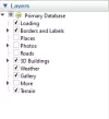
All being well you should find Terrain at the foot of the Layers stack

1601902668773.webp
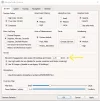
Tool>Options>3D View takes you to

1601902829441.webp

beware, a 3.0 exaggeration makes rolling hills look like the Andes (hyperbolic exaggeration! ;)). The "Navigation" tab allows you to vary your speed.

Otherwise all you need is a .KMZ/.KML or .GPX file of the chosen path (for Caminos see the resources area of this site).

Happy wanderings!
 
3rd Edition. More content, training & pack guides avoid common mistakes, bed bugs etc
I am also using the Conqueror app to walk the Camino Santiago in lieu of the Invierno in real life which was the plan to do in June. I started end of May, my data is transferred via Strava, 62 km to go, another two weeks more or less.
It is a great exercise - through aches and pains, lockdown back spasms, it motivates me to keep on walking. Kudos to my two eleven year old long legged fox terriers who is walking every step of the way with me.
I follow my progress on their website - the app is not great to view one’s route on the map.
The medal is not important for me too - the post is any way unreliable in my neck of the woods.
Next up will be Lejog - Land’s End to John o’ Groats, but first I am looking forward to arriving in Santiago de Compostela.
 
Hi! I'm currently using "The Conqueror" app to walk a virtual Camino with a few friends. I agree that it's expensive and I too have no interest in the medal. About 3 months ago, I did the Hadrian's Wall walk to see what the app was like. I actually stopped logging miles about 10 miles from the end because I didn't want to get the medal in the mail.

5 days ago, some friends and I decided to use the app for the Camino de Santiago walk. It's the best app I've been able to find. Here are my thoughts...

After using the app for the Hadrian's Wall walk, I was not super impressed. The app was not very intuitive and the street view is decent. Although, there were a few places I landed that had some pretty cool views like George Washington's ancestral home and seeing the wall in a number of places was fun. I didn't know what Hadrian's Wall was until I did the walk so it was fun to learn a bit of history.

When I saw that "The Conqueror" had added a Camino walk, I immediately told myself I would never do that! How in the world, after actually walking it, would I do it on some app! Yeah, a little snobby, I know. But, after talking with two friends, who are walking the Via di Francesco with me next fall (fingers crossed), we decided to give the app a go. So far, it's been very fun! We started with a kickoff time on my porch with tapas and Ramon Bilbao wine. While we were sitting there, a good friend and fellow Camino pilgrim "happen" to walk by. He joined us and shared tapas, wine, and stories from his Camino which was very special as my two friends have not yet walked it. Before he left, he prayed a Pilgrim blessing over us. Hmm...it seems the Camino provides in Portland, Oregon too!! As I walk, I carry my pilgrim shell and a rock for when I arrive at "Cruz de Ferro". I look at my Brierly's guide book to see where I would be if I were actually in Spain and reminisce over photos and my journal from my previous trips on the Camino. It's actually been really fun so far! I would recommend it.

Here are my thoughts on the app. While the app is not intuitive, at least to me, their customer service is incredible!! I asked multiple questions on their support email and had answers within 10 minutes. As I use the app, it becomes easier to use. I would say it's not ideal but it's the best I have found on the market.

Since starting, each of us has had someone who wanted to join us. So, we now have seven in our community and a few more considering joining. It's been fun to share communication and photos in the app with my group of friends each day.

If you want to follow our journey, I have a Facebook with the user name, Caminoclosner. Our community on The Conqueror is "Ramon Bilbao Babes." Let me know if you end up doing this app. I'd love to follow your journey!
I just finished Hadrian’s Wall on the Conquerer app. I walked the CF in 2012 and in 2013 took a friend back with me to finish from Santiago to Finestere. She and I will be starting the CF virtual soon. ☺️
 
I
Hello lisac,
Last September I walked Hadrian's Wall over six days in real life. It was awesome!
That’s so great! I really enjoyed seeing the photos of the wall and hope to see it in person at some point!
 
Train for your next Camino on California's Santa Catalina Island March 16-19
All being well you should find Terrain at the foot of the Layers stack

View attachment 84474
Tool>Options>3D View takes you to

View attachment 84475

beware, a 3.0 exaggeration makes rolling hills look like the Andes (hyperbolic exaggeration! ;)). The "Navigation" tab allows you to vary your speed.

Otherwise all you need is a .KMZ/.KML or .GPX file of the chosen path (for Caminos see the resources area of this site).

Happy wanderings!
Thank you so much!
 
I
Hello lisac,
Last September I walked Hadrian's Wall over six days in real life. It was awesome!
I am currently walking the Conqueror app Camino.
I have wanted to walk the Camino for several years but, until I retire in a few years I would never be able to take that amount of time off.
A few months ago my wife had a surgery and was told that walking was the best way for her to recover and build her core strength back. She discovered the Conqueror app and we both did a few virtual walks.
I posted about it on FB and a friend I haven't seen in several years popped in and said "You know, they have a Camino de Santiago walk..."
He has walked the Camino (teacher with summers off) and we have talked about it many times.
So here I am, fat and 60 years old trudging a couple of miles every morning through my neighborhood in Texas before work and dreaming about the someday that I will walk across Spain. I virtually arrived in Pamplona this morning.
Buen Camino!
 

❓How to ask a question

How to post a new question on the Camino Forum.

Most read last week in this forum

I saw a video with a rather harsh criticism of a small, municipal albergue on one of the less traveled caminos. They paid 9€. I thought: What does it cost a small municipality to renovate and keep...
On my last Camino (2023) I noticed that there were lots of tourists. It reminded me of a couple of quotes that I have read since my first Camino (2015) “A tourist demands, a pilgrim is grateful”...
"A complete guide to the world's greatest pilgrimage"[sic] by Sarah Baxter. In a British newspaper, The Telegraph. A right wing daily that does print interesting articles and essays...
Day 42 Week 6 460km walked (give or take) Today I had a revelation, an epiphany and a Divine Intervention... all in one day. Today the exreme pain in my soul is dissipating some... healed by the...
I've been trying to figure out how to use the Gronze app and as a first step I need to translate into English - I searched topics on the Forum, thought I found what I was looking for, and Yay! I...
There was a recent thread about EST (Erhard Seminars Training) which I have to say I have never hear of, but it got me thinking. I undertook some rather 'left field' training about 10 years ago...

Featured threads

❓How to ask a question

How to post a new question on the Camino Forum.

Featured threads

Forum Rules

Forum Rules

Camino Updates on YouTube

Camino Conversations

Most downloaded Resources

This site is run by Ivar at

in Santiago de Compostela.
This site participates in the Amazon Affiliate program, designed to provide a means for Ivar to earn fees by linking to Amazon
Official Camino Passport (Credential) | 2024 Camino Guides
Back
Back
Top