• ⚠️ Emergency contact in Spain - Dial 112 and AlertCops app. More on this here.
  • Remove ads on the forum by becoming a donating member. More here.

Search 69,459 Camino Questions

First day: Besancon to Foucherans or Besancon to Ornans ?

camster

Active Member
Time of past OR future Camino
Camino Francés 2023
Hi everyone! I am entertaining walking the Via Francigena and during research, I realized that Ornans may have a lot to offer.
I want to start the pilgrimage from Besancon (do some tourism there the day before starting) and perhaps sleep in Foucherans on day 1.
Then maybe do a small 2nd day of 11kms and stop at Ornans so I have time to visit a little.
I don't think walking over 35kms on day 1 to Ornans is wise for the body, but also arriving late, I'm not sure it would give me time to sightsee.
On the Frances I remember taking tourism days (days off) in Burgos, Leon and the likes.
Is Ornans really worth it on the VF?
Thank you!
 
A selection of Camino Jewellery
Hi everyone! I am entertaining walking the Via Francigena and during research, I realized that Ornans may have a lot to offer.
I want to start the pilgrimage from Besancon (do some tourism there the day before starting) and perhaps sleep in Foucherans on day 1.
Then maybe do a small 2nd day of 11kms and stop at Ornans so I have time to visit a little.
I don't think walking over 35kms on day 1 to Ornans is wise for the body, but also arriving late, I'm not sure it would give me time to sightsee.
On the Frances I remember taking tourism days (days off) in Burgos, Leon and the likes.
Is Ornans really worth it on the VF?
Thank you!
Hello @camster

I can't help you to decide. I had taken a rest day in Besançon where there is plenty of interest to see.

But i did enjoy Ornans, and I didn't have far to go the next day so spent the morning after arriving seeing the town. Very fine museum/gallery for Gustave Courbet. And the town is quite picturesque. Nice church which was closed....but there was someone having an organ lesson inside, which was nice to hear.
I doubt if it is somewhere which is strictly worth a diversion. But for me a nice kind of half day break.

I was on day 32 so was reasonably fit! I walked from Besançon to Ornans - 26 km. I cannot remember anything particular about my route. I am not sure why it might be 32km. I know i hadn't really intended stopping in Ornans, but Etalans, but it was a public holiday weekend and I was having problem confirming accommodation. I was only booking each night a day in advance generally.

From Ornans I just went to Mouthier, 15km, which is why I was not in a hurry.

My route from Besançon. https://www.strava.com/activities/1543186293

My account of Ornans is here: https://walkingtim.com/day-33-ornans-to-mouthier/
 
Last edited:
Hello @camster

I can't help you to decide.

But i did enjoy Ornans, and I didn't have far to go the next day so spent the morning after arriving seeing the town. Very fine museum/gallery for Gustave Courbet. And the town is quite picturesque. Nice church which was closed....but there was someone having an organ lesson inside, which was nice to hear.
I doubt if it is somewhere which is strictly worth a diversion. But for me a nice kind of half day break.

I was on day 32 so was reasonably fit! I walked from Besancon to Ornans - 26 km. I cannot remember anything particular about my route. I am not sure why it might be 32km. I know i hadn't really intended stopping in Ornans, but Etalans, but it was a public holiday weekend and I was having problem confirming accommodation. I was only booking each night a day in advance generally.

From Ornans I just went to Mouthier, 15km, which is why I was not in a hurry.

My account of Ornans is here: https://walkingtim.com/day-33-ornans-to-mouthier/
Great, thank you for sharing! I'll have a look at your blog right away.
Besancon to Foucherans is 25km according to Brown, so another 11 to Ornans is over 30.
Unless you took another road, which I would love to know :)
 
A selection of Camino Jewellery
Great, thank you for sharing! I'll have a look at your blog right away.
Besancon to Foucherans is 25km according to Brown, so another 11 to Ornans is over 30.
Unless you took another road, which I would love to know :)
I have put my trace into the post above.

Generally speaking the route in France is always a bit speculative. Throughout France the "official" route is slightly imaginary I think - I am not being critical, but there is plenty of scope for adjusting it yourself. I was using three guide books - the old Raju (Cicerone before Sandy Brown) the Lightfoot and the Terre di Mezzo. None of those followed the same path.

It was surprisingly easy at times to shorten a day by judicious use of Google maps. If you stick to GR it will always be longer because it is very wary of ANY tarmac. Being a city person at heart I am not wary of tarmac when it makes sense!

I see I walked on a road for last 8km but this would have been after Foucherans. I think Tarcenay and Foucherans are the same place.

And interestingly, as I teamed up with a large group of French seniors after Ornans, I had an intense exposure to 'proper' non-tarmac walking for a week well off the tarmac!
I had 3 or 4 guides for the Francés that I researched and rewrote annotations from into the one I brought. I'll look up the other guides, thank you!
 
...I want to start the pilgrimage from Besancon (do some tourism there the day before starting) and perhaps sleep in Foucherans on day 1.
Then maybe do a small 2nd day of 11kms and stop at Ornans so I have time to visit a little.
I don't think walking over 35kms on day 1 to Ornans is wise for the body, but also arriving late, I'm not sure it would give me time to sightsee...
@timr is always a VF font of knowledge so any info from him is solid.

I walked Besancon to Ornans in a day & have recorded my kms as 30.
I was on Day 39 by then, perhaps a slower walker than Tim but I did start in London.

Incidentally, I had an unexpected 4 nights in Besancon to help recover from shin splints & don't recall any issues hitting the 30kms required on my first day back on the trail.
I do remember it was a very pleasant days walk, nothing too challenging & I even managed to time ducking a thunderstorm to appropriate cover!
Ornans is lovely but I felt my short time there (part afternoon & quick next morning) was enough for what I like to see/do.
My next day was Ornans to Lods which I have recorded as 22kms.
Enjoy the planning process. As Tim stated in his post, there's no definitive path so don't be afraid to go your Own Way.
Happy trails!
👣🌏
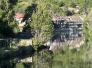
Ornans.jpg
Ornans...I think 🤔 unless memory fails!
 
The one from Galicia (the round) and the one from Castilla & Leon. Individually numbered and made by the same people that make the ones you see on your walk.
@timr is always a VF font of knowledge so any info from him is solid.

I walked Besancon to Ornans in a day & have recorded my kms as 30.
I was on Day 39 by then, perhaps a slower walker than Tim but I did start in London.

Incidentally, I had an unexpected 4 nights in Besancon to help recover from shin splints & don't recall any issues hitting the 30kms required on my first day back on the trail.
I do remember it was a very pleasant days walk, nothing too challenging & I even managed to time ducking a thunderstorm to appropriate cover!
Ornans is lovely but I felt my short time there (part afternoon & quick next morning) was enough for what I like to see/do.
My next day was Ornans to Lods which I have recorded as 22kms.
Enjoy the planning process. As Tim stated in his post, there's no definitive path so don't be afraid to go your Own Way.
Happy trails!
👣🌏
View attachment 174725
Ornans...I think 🤔 unless memory fails!
Thank you for sharing. Yes, I'm beginning to really understand that the path is not marked like the Francés. I continued searching a little and found the same thing you said, I won't be staying longer than passing through. I'll check out the lookout at the castle and sightsee, but no more, I think. There seems to be plenty of shops to grab snacks too. The picture you posted is gorgeous. Can't wait to see it in person.
 
think Tarcenay and Foucherans are the same place.
They are 2 different villages (not overly far apart if driving).

I had the old Cicerone guide by Raju which had a route via Tarcenay and Lightfoot guide which routed via Foucherans. Due to a heatwave and a summer weekend I did a shorter day to Tarcenay via the village of La Veze which was about 15km because I got accomodation there. But I missed part of the gorge walk from Foucherans. The route via Tarcenay was on road from La Veze, but up to Tarcenay on quiet country roads though after Tarcenay a busier road (though as I did it early morning so no traffic). The next day I headed past Ornans - (and one reason accommodation was difficult that weekend was a huge antique fair there)- to the next village were I camped. But this Tarcenay variant is about 24km from Besancon to Ornans.

I walked in 2019 and the marking of the route as a GR way was far from complete. And like TimR I often made my own way. Some of this is due to the official GR rules which heavily favour no tarmac even if you walk a long loop to avoid 100m of a quiet country road. (On compostelle/camino routes in France that coincide with GR routes it is common to see local pilgrim groups mark more direct routes in some sections, but this is rare on the VF though they do exist) . Secondly, sometimes finding accommodation will make one go off piste from the marked route.
 
Last edited:
I would plan for the shorter distance but expect to do the longer one. You might want to book accommodation last minute.

The difference between the two would be the weather. When it rains, it really comes down so you'll be wetter, colder and it will affect your grip. Same will apply through Switzerland where you will not want to be caught out in the open in the rain.
 
Ideal sleeping bag liner whether we want to add a thermal plus to our bag, or if we want to use it alone to sleep in shelters or hostels. Thanks to its mummy shape, it adapts perfectly to our body.

€46,-
I heard markings get better closer to Italy. Can I expect things to improve in Switzerland? Is the whole VF like that where you can take the tarmac or country road all the time? I take it it's different than the camino in that way too.
 
Thank you for sharing. Yes, I'm beginning to really understand that the path is not marked like the Francés.
The path is much more defined in Switzerland and especially in Italy. You really need GPX/the VF app in France. In Italy you could almost (in 2018) just go by route marking, with GPX as back up. And I daresay that is more true today.
 
Here is a thread on the route from a couple of weeks ago. Note the comment from @Paul-CH about the Swiss Mobility App. Both he and I did part of the CH/IT route in the last two weeks and as @timr says it is very well signposted in Switzerland (Route 70) and Italy (Red/white with the little pilgrim character)

We did have offline GPX maps but rarely needed them. Gives you more time to take in the scenery.

 
Ideal pocket guides for during & after your Camino. Each weighs only 1.4 oz (40g)!
Here is a thread on the route from a couple of weeks ago. Note the comment from @Paul-CH about the Swiss Mobility App. Both he and I did part of the CH/IT route in the last two weeks and as @timr says it is very well signposted in Switzerland (Route 70) and Italy (Red/white with the little pilgrim character)

We did have offline GPX maps but rarely needed them. Gives you more time to take in the scenery.

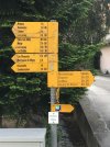
I remember being puzzled the first time by Swiss direction markers for walkers. They are plentiful and very comprehensive. They don't show the distance but the time it will take you to walk!

Swiss directions.jpeg
 
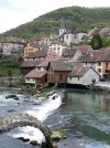
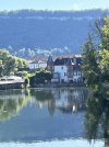
Above: Two pics of Ornans from Bastille Day (14 July, 2022). I concur that it is worth a 1/2 day, but I walked around the periphery of the town in about an hour. Unfortunately, the museum and church were both closed. I followed Timr's route from Besonçon with a couple of minor deviations and it was about 15 miles to Ornans.
Signage and directions improve greatly in Switzerland, and in Italy they are pretty good, but the responsibility for the signs rests on the region and it varies quite a bit from region to region, generally improving as you approach Rome. The route across the Po Basin is well waymarked, as is the route over the Apennine Mountains (but where again there are multiple route options on the higher areas like from Berceto to Pontremoli, or even from Fornovo di Taro to Berceto.
I just finished the last 400km from Lucca to Rome on Pentecost Sunday (19 May); and now I'm thinking of walking French portions of the route again (starting in London on the newly minted route from London to Canterbury)... but first I'll be walking the West Highland Way next April.
Buon Cammino.
 
The one from Galicia (the round) and the one from Castilla & Leon. Individually numbered and made by the same people that make the ones you see on your walk.
Here is a thread on the route from a couple of weeks ago. Note the comment from @Paul-CH about the Swiss Mobility App. Both he and I did part of the CH/IT route in the last two weeks and as @timr says it is very well signposted in Switzerland (Route 70) and Italy (Red/white with the little pilgrim character)

We did have offline GPX maps but rarely needed them. Gives you more time to take in the scenery.

I had seen the thread in the beginning in july, but missed the new posts. Thank you. I got the apps and will enjoy having them for sure!
 
I remember being puzzled the first time by Swiss direction markers for walkers. They are plentiful and very comprehensive. They don't show the distance but the time it will take you to walk!

View attachment 174734
Haha it's funny seeing indications like that on sign posts. Here, where I live, we do express distance in that way when we talk. We'll say it's 2 hours away, or a 10 minute drive, we never say it's so and so kms far. But to see it on sign posts is next level! :D
I'm from Montreal, btw.
 
Above: Two pics of Ornans from Bastille Day (14 July, 2022). I concur that it is worth a 1/2 day, but I walked around the periphery of the town in about an hour. Unfortunately, the museum and church were both closed. I followed Timr's route from Besonçon with a couple of minor deviations and it was about 15 miles to Ornans.
Signage and directions improve greatly in Switzerland, and in Italy they are pretty good, but the responsibility for the signs rests on the region and it varies quite a bit from region to region, generally improving as you approach Rome. The route across the Po Basin is well waymarked, as is the route over the Apennine Mountains (but where again there are multiple route options on the higher areas like from Berceto to Pontremoli, or even from Fornovo di Taro to Berceto.
I just finished the last 400km from Lucca to Rome on Pentecost Sunday (19 May); and now I'm thinking of walking French portions of the route again (starting in London on the newly minted route from London to Canterbury)... but first I'll be walking the West Highland Way next April.
Buon Cammino.
A shame about the closed places. I plan on arriving relatively early in the morning, so I should have time enough to sightsee. Thank you for the lovely pictures! :)
 
Get a spanish phone number with Airalo. eSim, so no physical SIM card. Easy to use app to add more funds if needed.
A shame about the closed places. I plan on arriving relatively early in the morning, so I should have time enough to sightsee. Thank you for the lovely pictures! :)
I think it is something to bear in mind that in France generally, (and I approve greatly), they do take holidays and weekends quite seriously. And they often faire le pont if a holiday is on a Thursday or a Tuesday!

In UK we are sadly entirely used to everything being open seven days a week. Not so in France. In particular when crossing France where especially in the north, where there is not much in the way of bars and shops at the best of times, you need to make the most of it when you find somewhere open!

But i would go tomorrow again if I could!!
 
Hi everyone! I am entertaining walking the Via Francigena and during research, I realized that Ornans may have a lot to offer.
I want to start the pilgrimage from Besancon (do some tourism there the day before starting) and perhaps sleep in Foucherans on day 1.
Then maybe do a small 2nd day of 11kms and stop at Ornans so I have time to visit a little.
I don't think walking over 35kms on day 1 to Ornans is wise for the body, but also arriving late, I'm not sure it would give me time to sightsee.
On the Frances I remember taking tourism days (days off) in Burgos, Leon and the likes.
Is Ornans really worth it on the VF?
Thank you!
As @timr says, there is the Courbet Museum, which I definitely thought worth a visit. There have been route changes since @timr's day - and mine - which account for the greater distance.
 
I used the cicerone guide by Alison Raju when i did this in 2019 and I have recorded it as 24km to Ornans.
I think it was mostly on the road and as I am quite happy with that I often look for a shorter route on google maps. As others have said the GR route can to go off on a circuitous route. The day I was there was a holiday (8th May )and everywhere was shut but it was a lovely place to just walk round. My next two stops were Moutiere -Haute-Piere and then Pontalier. good luck with your planning and your pilgrimage.
 
3rd Edition. More content, training & pack guides avoid common mistakes, bed bugs etc
I used the cicerone guide by Alison Raju when i did this in 2019 and I have recorded it as 24km to Ornans.
I think it was mostly on the road and as I am quite happy with that I often look for a shorter route on google maps. As others have said the GR route can to go off on a circuitous route. The day I was there was a holiday (8th May )and everywhere was shut but it was a lovely place to just walk round. My next two stops were Moutiere -Haute-Piere and then Pontalier. good luck with your planning and your pilgrimage.
Gotcha! So the GR are not necessarily true to the pilgrimage route anyway. Good to understand.
 
Gotcha! So the GR are not necessarily true to the pilgrimage route anyway.
You are right, but imagine Sigeric the Serious did his travel in year 990. Probably he didn't had so many roads he could have used.
It helps when you are able to read a good quality map. If you uses one which shows you all hiking trails you may select the one that fit's you depending on the weather. It means on a rainy day I didn't mind to stay on the road instead of using the swampy forest tracks.
I did Canterbury-St.Maurice and came home today from St.Maurice-Vercelli. It was terrible hot in the last days 30°C and humidity over 75%. The last part Vercelli-Rome will follow, but not defined yet when.
 

Most read last week in this forum

Hi everyone. I am walking from Lucca to Rome from mid October through November. Will I see many other pilgrims? Alternatively I could walk the Francis again to see more pilgrims around, but...
I've walked the Camino Ingles and Primitivo a few years ago, and now thinking of taking on a few days of the via francigena in late November with my boyfriend. Both of us are relatively capable...

âť“How to ask a question

How to post a new question on the Camino Forum.

Forum Rules

Forum Rules

Camino Updates on YouTube

Camino Conversations

Most downloaded Resources

This site is run by Ivar at

in Santiago de Compostela.
This site participates in the Amazon Affiliate program, designed to provide a means for Ivar to earn fees by linking to Amazon
Official Camino Passport (Credential) | 2024 Camino Guides
Back
Top