• ⚠️ Emergency contact in Spain - Dial 112 and AlertCops app. More on this here.
  • Remove ads on the forum by becoming a donating member. More here.

Search 74,075 Camino Questions

The REAL Camino Viejo - a new project for a Camino alternative.

Paulo Arantes

Member
Time of past OR future Camino
Frances 2017
Viejo/Olvidado/Invierno Oct/Nov 2024
I would like to share with you a plan that I have been making in recent months to be carried out in October this year and that would not be possible without the valuable help of so many members of this forum.
Thank you very much to everyone who posts quality content here. Special thanks to @WestKirsty, @caminka, @VNwalking, @peregrina2000 and several others who help with small details that help build this project.
Justification: after my Camino Frances in 2017 (I'm the guy who broke my tibias due to a stress fracture) I always wanted to repeat the Camino de Santiago. At first I had planned to repeat the Camino Frances, but after starting my physical training I saw that there was an opportunity to look for an alternative to the path. Along with this, I think other options are opportune in light of the beds race we have seen in recent months.
Then I came across a post by @caminka where she mentioned the “Camino Viejo”, which is often confused with the “Camino Olvidado” but is a different path.
Studying maps of Roman roads in the 11th century, I saw that the main exit from Pamplona was not along the Camino Frances but via Victória Gasteiz. @caminka and @VNwalking had already mapped sections of this other path and that attracted me. Taking a trip through the mountains of Cantabria was what I dedicated myself to in the last few days. Judging by the Roman roads, the most logical thing would probably be to have a connection with the Camino Francês in Burgos, however, to avoid this union, I traced a route like @caminka to join the Camino Olvidado in Aguilar de Campoo and then continue through the Cantabrian mountains, on the Camino Olvidado.
Therefore, at the end of Olvidado and maintaining the idea of not overloading the Camino Frances, in Ponferrada I choose to walk the Camino de Invierno.
It is a pilgrimage with a total of 911 km where I plan to dedicate around 45 days with short stages. All construction was carried out planning cities where there is some minimal infrastructure, however, I will give you this confirmation when I return from the route.
I provide below some images with the superimposition of Roman roads over current cities showing that historically this path was a more likely option and the link to AllTrails where I have my path already mapped out as I intend to do. I must incorporate a little of the @peregrina2000 adventurous spirit and make some detours. Some stages I chose to pass through some mountains to enjoy the view.
I think we have a new option to grow, strengthen local commerce and avoid overloading the French Way.
This project is still in development, I am scheduled to start my walk on October 3rd from Pamplona and any suggestions are always very welcome.
Again, thank you to everyone who has contributed.
Ultreia!

Camino Viejo as planned

Mapa sobreposto 1.png
 
Train for your next Camino on California's Santa Catalina Island March 30 to April 2
Oh! Just to let you know, right at the beginning of the path, when leaving Pamplona, I took the liberty of not going through the valley and am walking along the top of the mountain range on your left. The correct route along the Roman road would be to pass through the valley and even climb the mountain range to the right to visit the Sanctuary of San Miguel in Excelsis.

San Miguel in Excelsis Sanctuary
 
Get a spanish phone number with Airalo. eSim, so no physical SIM card. Easy to use app to add more funds if needed.
Oh, it would be wonderful to have a live report. I have started mapping things out several times, but always find that there are just so many choices that it’s kind of overwhelming to plot out.

I have been thinking that since I will be pushing 75 next year, I might be past the point where I can walk this route, but since you say you are planning short stages I might be able to do it. 911 km divided by 45 days comes out to a bit more than 20 per day, so i will be following this with a LOT of interest.

Hope you can report live, and please give us whatever lodging info you can find. There are lots and lots of casas rurales, but as I contacted many of them, I learned that they are not available for single room renting, just the whole house. So any info you can get would be great!!!

The most spectacular parts of the Olvidado. come after Aguilar, in my opinion, so you’ve got the perfect itinerary!
 
I would like to share with you a plan that I have been making in recent months to be carried out in October this year and that would not be possible without the valuable help of so many members of this forum.
Thank you very much to everyone who posts quality content here. Special thanks to @WestKirsty, @caminka, @VNwalking, @peregrina2000 and several others who help with small details that help build this project.
Justification: after my Camino Frances in 2017 (I'm the guy who broke my tibias due to a stress fracture) I always wanted to repeat the Camino de Santiago. At first I had planned to repeat the Camino Frances, but after starting my physical training I saw that there was an opportunity to look for an alternative to the path. Along with this, I think other options are opportune in light of the beds race we have seen in recent months.
Then I came across a post by @caminka where she mentioned the “Camino Viejo”, which is often confused with the “Camino Olvidado” but is a different path.
Studying maps of Roman roads in the 11th century, I saw that the main exit from Pamplona was not along the Camino Frances but via Victória Gasteiz. @caminka and @VNwalking had already mapped sections of this other path and that attracted me. Taking a trip through the mountains of Cantabria was what I dedicated myself to in the last few days. Judging by the Roman roads, the most logical thing would probably be to have a connection with the Camino Francês in Burgos, however, to avoid this union, I traced a route like @caminka to join the Camino Olvidado in Aguilar de Campoo and then continue through the Cantabrian mountains, on the Camino Olvidado.
Therefore, at the end of Olvidado and maintaining the idea of not overloading the Camino Frances, in Ponferrada I choose to walk the Camino de Invierno.
It is a pilgrimage with a total of 911 km where I plan to dedicate around 45 days with short stages. All construction was carried out planning cities where there is some minimal infrastructure, however, I will give you this confirmation when I return from the route.
I provide below some images with the superimposition of Roman roads over current cities showing that historically this path was a more likely option and the link to AllTrails where I have my path already mapped out as I intend to do. I must incorporate a little of the @peregrina2000 adventurous spirit and make some detours. Some stages I chose to pass through some mountains to enjoy the view.
I think we have a new option to grow, strengthen local commerce and avoid overloading the French Way.
This project is still in development, I am scheduled to start my walk on October 3rd from Pamplona and any suggestions are always very welcome.
Again, thank you to everyone who has contributed.
Ultreia!

Camino Viejo as planned

View attachment 171902
That's a cool map wirh superimposed roman roads. I never noticed before that Zaragoza is such a road hub. And that there is a road (or a series of roads) that effectively encircle the whole of Iberian peninsula!
 
Looking at your plotted trail, I have a few observations:

- are you sure you want to exit Pamplona on a main road and a motorway?
- that's an interesting start to Olloz, I have a vague memory of albergue there?
- is that the less steep descent into Puebla de Arganzon? I'm interested how it's waymarked
- there is pilgrim albergue right in the centre of Miranda de Ebro
- please check the actual state of footbridge across the Ebro into Sobron, as far as I know it hasn't been repaired yet and you will have to backtrack a lot!
- if you can, plot your way via Tobera south of Frias, or make a detour, I regret not visiting it
- check albergues in Quintana de Valdivieso, they were closed last year
- N-627 before reaching Aguillar is a very very busy highway
- it's a very long day from Cervera to Guardo, you mentioned shorter stages?

If I spot anything else, I'll post here. Please let us know how your camino went, there are few reports on Viejo and Olvidado.

And buen camino!
 
Perfect memento/gift in a presentation box. Engraving available, 25 character max.
This is an excellent route project idea! I (altruistically) hope it goes very well for you, and (selfishly) hope that you will share your findings so that others can follow in your footsteps.
 
Hi @caminka,
The plan I shared is just to be a reference on what I'd like to do. I have another one with all possible variations.
I am building a sheet with all this information. When it's ready I'll post it here.
For now it is somewhat like this:

1000126942.jpg

Sorry, I took clipped this from my phone. On each possible stop I've been collecting places to eat and presence of albergues, Casa Rural or Hotels.

-are you sure you want to exit Pamplona on a main road and a motorway?
Well, the Pamplona exit on that road has been a pain to get rid from. I think it won't be pleasant but could not find another easy way out. Any suggestions?

- that's an interesting start to Olloz, I have a vague memory of albergue there?
There are 3 hotels and the Albergue I found I could not get in contact with them yet.

- is that the less steep descent into Puebla de Arganzon? I'm interested how it's waymarked
There are other ways closer to the road. As it is a shorter stage (18 km) I chose to go on through the top of the mountain for the view.

- there is pilgrim albergue right in the centre of Miranda de Ebro
Right. Hope I'll be able to stay there.

- please check the actual state of footbridge across the Ebro into Sobron, as far as I know it hasn't been repaired yet and you will have to backtrack a lot!
You say the bridge right before the dam, isn't it? I'm aware I'll have to check it. If it's not repaired, I have 2 other options sooner that will make me walk on pave road but ok...

- if you can, plot your way via Tobera south of Frias, or make a detour, I regret not visiting it
Well, I would have to choose between Quintana Martín Galíndez and Tobera, coming from Barcina del Barco? I'll think about it.

- check albergues in Quintana de Valdivieso, they were closed last year
Also found 3 hotels there but could not contact the Albergue. I'll keep trying.

- N-627 before reaching Aguillar is a very very busy highway
Yes it is. I was able to avoid it by walking south most of the way.

- it's a very long day from Cervera to Guardo, you mentioned shorter stages?
Yes it is. I'm keeping Tarilonte de la Peña as a probable break point on this stage.

Most of my stages are around 20km but there are a few that go beyond that, mostly on Olvidado and Invierno. On the Viejo I'm planning the longest stretch is 27 km, from Miranda de Ebro to Sobron.

It's a work in progress that I'll keep working on even when I'm walking.

Thank you so much for all your attention and suggestions. I'll keep them in mind.
 
Yes it is. I'm keeping Tarilonte de la Peña as a probable break point on this stage.
Forum members have also stayed at the rooms above Bar Mylo in Santibañez de la Peña. 979 860 294. This is closer to Guardo than Tarilonte, but if you are planning to walk the variante through Caminayo (highly recommended), you can then go from Santibañez through Guardo to Velilla and then have a shorter day the next day from Velilla -Caminayo-Puente Almuhey. In Velilla Hostal Stop. Also Casa Moura 979 861 098, 30 € with breakfast.
 
The 2024 Camino guides will be coming out little by little. Here is a collection of the ones that are out so far.
Oh! So exciting, @Paulo Arantes !
I really look forward to what you come up with and hope you post live updates here.
Like Laurie, this is on my list, way at the top - but so far I cannot manage a long enough block of time to do it.
And the body is aging...so I'll be very interested to see what your short stages are.

I see you follow the marked path from Sobron. @Bad Pilgrim had a interesting time on that stretch, and I'd be considering going straight to Frias by crossing the river at the second bridge, here:
Screenshot_20240607_063954_OsmAnd.jpg
(Our planning thread had some discussion about that, and more details of a possible route.) But I wonder if this is possible because of the tunnels on the road - can one walk through them? A question for someone local, perhaps when you get to Sobron.

Another thought is if the Invierno begins to get clogged, another alternative is the Via Kunig from Ferreiras, which @alansykes did last year. It also follows a Roman road through Lugo.

is that the less steep descent into Puebla de Arganzon? I'm interested how it's waymarked
There are other ways closer to the road. As it is a shorter stage (18 km) I chose to go on through the top of the mountain for the view.
is that the less steep descent into Puebla de Arganzon? I'm interested how it's waymarked
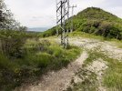
When you reach the top of the hill follow the path to the right along the ridgetop, until reaching the powerline. There is a waymark on the pylon - turn left to go downhill there; it's very easy walking.
20190523_111946.jpg
 
Hi @caminka,
The plan I shared is just to be a reference on what I'd like to do. I have another one with all possible variations.
I am building a sheet with all this information. When it's ready I'll post it here.
For now it is somewhat like this:

View attachment 171939

Sorry, I took clipped this from my phone. On each possible stop I've been collecting places to eat and presence of albergues, Casa Rural or Hotels.

-are you sure you want to exit Pamplona on a main road and a motorway?
Well, the Pamplona exit on that road has been a pain to get rid from. I think it won't be pleasant but could not find another easy way out. Any suggestions?

- that's an interesting start to Olloz, I have a vague memory of albergue there?
There are 3 hotels and the Albergue I found I could not get in contact with them yet.

- is that the less steep descent into Puebla de Arganzon? I'm interested how it's waymarked
There are other ways closer to the road. As it is a shorter stage (18 km) I chose to go on through the top of the mountain for the view.

- there is pilgrim albergue right in the centre of Miranda de Ebro
Right. Hope I'll be able to stay there.

- please check the actual state of footbridge across the Ebro into Sobron, as far as I know it hasn't been repaired yet and you will have to backtrack a lot!
You say the bridge right before the dam, isn't it? I'm aware I'll have to check it. If it's not repaired, I have 2 other options sooner that will make me walk on pave road but ok...

- if you can, plot your way via Tobera south of Frias, or make a detour, I regret not visiting it
Well, I would have to choose between Quintana Martín Galíndez and Tobera, coming from Barcina del Barco? I'll think about it.

- check albergues in Quintana de Valdivieso, they were closed last year
Also found 3 hotels there but could not contact the Albergue. I'll keep trying.

- N-627 before reaching Aguillar is a very very busy highway
Yes it is. I was able to avoid it by walking south most of the way.

- it's a very long day from Cervera to Guardo, you mentioned shorter stages?
Yes it is. I'm keeping Tarilonte de la Peña as a probable break point on this stage.

Most of my stages are around 20km but there are a few that go beyond that, mostly on Olvidado and Invierno. On the Viejo I'm planning the longest stretch is 27 km, from Miranda de Ebro to Sobron.

It's a work in progress that I'll keep working on even when I'm walking.

Thank you so much for all your attention and suggestions. I'll keep them in mind.
For Pamplona exit, have you seen my wikiloc? It's from 2012 but it should be still passable.
https://www.wikiloc.com/hiking-trails/camino2012-113-pamplona-hirriberi-20644522

And do you know of trail Vuelta de Pamplona? I think it's GR 20 or 220 or similar. It is GR waymarked (red and white) and I used in 2012 to cut from Monreal on camino aragones to Huarte.

There were also local waymarked walks I used on exiting pamplona. I am sure sth can be cobbled together.

Sorry, I can't make www links work on my phone. They are working when they are posted, cool!
 
Get a spanish phone number with Airalo. eSim, so no physical SIM card. Easy to use app to add more funds if needed.
Oh! So exciting, @Paulo Arantes !
I really look forward to what you come up with and hope you post live updates here.
Like Laurie, this is on my list, way at the top - but so far I cannot manage a long enough block of time to do it.
And the body is aging...so I'll be very interested to see what your short stages are.

I see you follow the marked path from Sobron. @Bad Pilgrim had a interesting time on that stretch, and I'd be considering going straight to Frias by crossing the river at the second bridge, here:
View attachment 171941
(Our planning thread had some discussion about that, and more details of a possible route.) But I wonder if this is possible because of the tunnels on the road - can one walk through them? A question for someone local, perhaps when you get to Sobron.

Another thought is if the Invierno begins to get clogged, another alternative is the Via Kunig from Ferreiras, which @alansykes did last year. It also follows a Roman road through Lugo.


When you reach the top of the hill follow the path to the right along the ridgetop, until reaching the powerline. There is a waymark on the pylon - turn left to go downhill there; it's very easy walking.
View attachment 171940
I followed the road with tunnels out of Sobron. It was low cloudy day so no views from above, at least I wanted views from below. I saw maybe two cars but perhaps it was Sunday. Tunnels were short but I don't remember if the road through was wide enough for one or two cars.

I thought the plotted path into Puebla de Arganzon resembled a bit this alternative.
 
I followed the road with tunnels out of Sobron. It was low cloudy day so no views from above, at least I wanted views from below. I saw maybe two cars but perhaps it was Sunday. Tunnels were short but I don't remember if the road through was wide enough for one or two cars.
Ah, good to know! Thanks, @caminka. 🙏😍

Our planning thread
Here's that planning thread; I forgot to post the link:

Another question arises looking at your wonderful spreadsheet, Paulo. There seems to be a challenge finding accommadation after Orbaneja, making for a horribly long slog into Aguilar de Campoo and not all of us would be happy with that distance. So I will be curious to know what you discover.
 
The one from Galicia (the round) and the one from Castilla & Leon. Individually numbered and made by the same people that make the ones you see on your walk.
The only thing that looks odd to me is that detour on the Guardo > Puente Almuhey section -- though I can see that without that detour, it would be a pretty short day.

Historically, the old route would have been via Lugo, but it makes perfect sense to avoid that in the 2020s.

Erice does look like a bit of a bottleneck out of Pamplona in that direction, and I can see no better itinerary that way than yours -- but there is a riverside trail from Pamplona to Ororbia and some good options (more riverside) from there to Anotz on your itinerary.
 
@Paulo I loved your spreadsheet! @RodrigoD & I are leaving soon for the Camino Português and that kind of spreadsheet is on my to-do list. I wish you the best in your planning/creating.
 
It is a pilgrimage with a total of 911 km where I plan to dedicate around 45 days with short stages
Thank you very much, @Paulo Arantes ! This is a wonderful project I will be following with much interest!
I have been thinking that since I will be pushing 75 next year, I might be past the point where I can walk this route, but since you say you are planning short stages I might be able to do it. 911 km divided by 45 days comes out to a bit more than 20 per day, so i will be following this with a LOT of interest.
In our case, as we're distance challenged slow walkers, I will be very interested in seeing if there are options to reduce the average down to a 15 km Per day.
I am building a sheet with all this information. When it's ready I'll post it here.
Thank you again! Looking forward to this spreadsheet.

¡Buen Camino!
 
Fail to prepare? reduce your risk by buying this book full of practical info.
2nd ed.
I am not sure if we had found these sites when we were doing the Viejo planning thread in covid confinement, but here are some things that might help with planning. I’m learning that in some places this route is called the “Ruta Pamplonesa del Camino Olvidado.”


The author of the website below, rocjumper, is a very reliable member of Wikiloc. I use his tracks a lot!

 
please check the actual state of footbridge across the Ebro into Sobron, as far as I know it hasn't been repaired yet and you will have to backtrack a lot!
You say the bridge right before the dam, isn't it? I'm aware I'll have to check it. If it's not repaired, I have 2 other options sooner that will make me walk on pave road but ok...

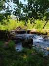
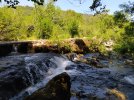
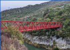
The remains of the old bridge are still visible but there's a nice new red bridge to cross the river. However, last year the trail to get to it was roped off due to rock falls. Luckily, there's actually a natural bridge near there to get to the Sobron side and just requires a short time on the road. My Wikiloc tracks from last year have that crossing.

I'm looking forward to following!!
 
A great book to listen to while training for the Camino or to relive the experience!
I know you plotted your trail through the mountains here, but just in case: https://zamartze.org/camino-de-santiago/. As I understand it, pilgrims can stay at monasterio Zamartze.
I did (that was rather a special case back then and they haven't yet found the pilgrim staff!) but I remember reading about another pilgrim who stayed there more recently. Don't remember if it was pre or post c, though.
 
Get a spanish phone number with Airalo. eSim, so no physical SIM card. Easy to use app to add more funds if needed.
Found this around Villanueva de la Nia: https://www.cantabriarural.com/luga...no-natural-del-ebro-en-cantabria-etapa-3.html. Don't know how recent it is, though.
La Románika de Fellini is a minimum of 2 nights, and the price quoted on Booking is 612 ChF (I'm searching from Switzerland, so it's an automatic conversion, but you can do the math...).

The Casa Rural Maté has two options, one for 4 people and one for 5. ANnothet one of those situations where you need to rent the whole house.

Posada Peñasalve is off the camino but not that far, a bit past VdlN; more useful or single walkers. 68€ on Booking. Still not cheap but it's possible to imagine staying there.
 
As I understand it, pilgrims can stay at monasterio Zamartze.
I have written to the monastery to ask about this. It seems like the only way for me to get up to San Miguel without having a really long stage. As I calculate it, it’s 23 to Irutzun from Pamplona, where there’s lodging. Then the next day about 14 to Zamartze, and from there about a 10-15 kim loop up to the church (the difference in kms depends on whether you want to go out to see the dolmens or just up and back to the church).

The monastery website indicates that they do have lodging, but the focus seems to be on groups. I have written to ask about individual pilgrims, fingers crossed!
 
The one from Galicia (the round) and the one from Castilla & Leon. Individually numbered and made by the same people that make the ones you see on your walk.
The remains of the old bridge are still visible but there's a nice new red bridge to cross the river. However, last year the trail to get to it was roped off due to rock falls. Luckily, there's actually a natural bridge near there to get to the Sobron side and just requires a short time on the road. My Wikiloc tracks from last year have that crossing.

I'm looking forward to following!!
That is excellent news! I checked it and it crosses the river a little to the west from previous footbridge.
I don't remember any natural bridges across the river, though. Any pictures?
 
Last edited:
La Románika de Fellini is a minimum of 2 nights, and the price quoted on Booking is 612 ChF (I'm searching from Switzerland, so it's an automatic conversion, but you can do the math...).

The Casa Rural Maté has two options, one for 4 people and one for 5. ANnothet one of those situations where you need to rent the whole house.

Posada Peñasalve is off the camino but not that far, a bit past VdlN; more useful or single walkers. 68€ on Booking. Still not cheap but it's possible to imagine staying there.
From Switzerland! I walked Via Jacobi last year and in two weeks and a bit if change I am starting Via Gebenennsis. Can't wait! :)
 
The one from Galicia (the round) and the one from Castilla & Leon. Individually numbered and made by the same people that make the ones you see on your walk.
I have written to the monastery to ask about this. It seems like the only way for me to get up to San Miguel without having a really long stage. As I calculate it, it’s 23 to Irutzun from Pamplona, where there’s lodging. Then the next day about 14 to Zamartze, and from there about a 10-15 kim loop up to the church (the difference in kms depends on whether you want to go out to see the dolmens or just up and back to the church).

The monastery website indicates that they do have lodging, but the focus seems to be on groups. I have written to ask about individual pilgrims, fingers crossed!
Perhaps you could stay st san miguel? There is a huge closed-in porch. There were also some basic unstaffed refugios around it, if I remember correctly.

Monastery's site with lodging and eating info in its vicinity: https://www.sanmigueldearalar.org/informacion-practica/restaurantes-hoteles-bares-campings/.
 
Last edited:
3rd Edition. Vital content training & pack guides avoid common mistakes, bed bugs etc
That valley....on either side there are wonders.
San Miguel on one side and a bit farther along Berian on the other. Choices, choices. Or maybe an elaborate zig-zag? Remind us, please, @caminka - what did you do?
It's obviously a very ancient route.

When I slept in CR in Hirriberri, the owner was an enthusiastic history buff and was very excited when he learned I am archaeologist, historian and medieval buff. He arranged for me to sleep in Zamartze monastery, meet a local historian and potter around and participate in archaeological dig at the monastery.

In the afternoon, the local historian drove me up to Aralar where we were allowed to press our noses to the glass protecting the enamelled altar and were invited backstage to admire and touch san Miguel's statue. The view across to Beriain was amazing and that's when I decided I definitely want to climb it.

The next day I climbed to Beriain, battled the winds to crawl onto the plateau, lost my scallop, complained to clouds obscuring the view from the cute ermita on top, retrieved my scallop which was found by hikers who came up behind me, and enjoyed glorious views, karst and flowers when the clouds lifted.

The joys of untravelled caminos!
 
On the way from puerto de Lizarraga west, the plotted route passes two ermitas with attached 'albergues'. Essentially a room with a fireplace and perhaps a bench, with an unlocked door (so that sheep can't come in) where it's possible to bivouac.
I think there was a spring close to the second ermita.
 
Get a spanish phone number with Airalo. eSim, so no physical SIM card. Easy to use app to add more funds if needed.
That is excellent news! I checked it and it crosses the river a little to the west from previous foot footbridge.
I don't remember any natural bridges across the river, though. Any pictures?

I don't know if natural bridge is the right word but it was marked on Mapy.cz as a path. Here are some photos from that point:

IMG_20230615_140357.jpg IMG_20230615_140740.jpg IMG_20230615_140837.jpg IMG_20230615_141220.jpg
 
Hi @caminka,
The plan I shared is just to be a reference on what I'd like to do. I have another one with all possible variations.
I am building a sheet with all this information. When it's ready I'll post it here.
For now it is somewhat like this:

View attachment 171939

Sorry, I took clipped this from my phone. On each possible stop I've been collecting places to eat and presence of albergues, Casa Rural or Hotels.

-are you sure you want to exit Pamplona on a main road and a motorway?
Well, the Pamplona exit on that road has been a pain to get rid from. I think it won't be pleasant but could not find another easy way out. Any suggestions?

- that's an interesting start to Olloz, I have a vague memory of albergue there?
There are 3 hotels and the Albergue I found I could not get in contact with them yet.

- is that the less steep descent into Puebla de Arganzon? I'm interested how it's waymarked
There are other ways closer to the road. As it is a shorter stage (18 km) I chose to go on through the top of the mountain for the view.

- there is pilgrim albergue right in the centre of Miranda de Ebro
Right. Hope I'll be able to stay there.

- please check the actual state of footbridge across the Ebro into Sobron, as far as I know it hasn't been repaired yet and you will have to backtrack a lot!
You say the bridge right before the dam, isn't it? I'm aware I'll have to check it. If it's not repaired, I have 2 other options sooner that will make me walk on pave road but ok...

- if you can, plot your way via Tobera south of Frias, or make a detour, I regret not visiting it
Well, I would have to choose between Quintana Martín Galíndez and Tobera, coming from Barcina del Barco? I'll think about it.

- check albergues in Quintana de Valdivieso, they were closed last year
Also found 3 hotels there but could not contact the Albergue. I'll keep trying.

- N-627 before reaching Aguillar is a very very busy highway
Yes it is. I was able to avoid it by walking south most of the way.

- it's a very long day from Cervera to Guardo, you mentioned shorter stages?
Yes it is. I'm keeping Tarilonte de la Peña as a probable break point on this stage.

Most of my stages are around 20km but there are a few that go beyond that, mostly on Olvidado and Invierno. On the Viejo I'm planning the longest stretch is 27 km, from Miranda de Ebro to Sobron.

It's a work in progress that I'll keep working on even when I'm walking.

Thank you so much for all your attention and suggestions. I'll keep them in mind.
According to Gronze, Ponferrada to Las MEdulas is 27.8 km. (Do you have a different route through that area in mind to come up with 21?) I broke that up in Villavieja (which is a great place to stay!) and felt like both the trek up to Villavieja and to Las Medulas the next day were quite enough. I can't imagine doing both in the same day -- especially if you're intending for this to be mostly kind of relaxed mileage.
 
Train for your next Camino on California's Santa Catalina Island March 30 to April 2
Very interesting idea.

I have just walked the Frances and then the San Salvador in Mar/Apr/May 2024. You'll have to carry food with you for the end of the stage Vegacervera - Buiza since there is no shop at Buiza. La Pola de Gordon has supermarkets and cafes/bars though.

North of Buiza is Villamanin de la Tercia which has the wonderful Ezequiel restaurant, and a big albergue next to the town hall which I didn't expect. Walking the national highway isn't recommended.

If it helps... I walked from Buiza to Villamanin via San Martín de la Tercia due to issues with accommodation and meals in Poladura de la Tercia on the San Salvador. Based on what I heard from my pilgrim friends the next day, my experience was definitely a better one than theirs (and Ezequiel was very generous with the food).

The route between Buiza and Villamanin on the San Salvador is marvellous, though this may be further north than you want to be since the Olvidado is further south of Vegacervera and crosses the San Salvador in La Robla.
 
Hi, @Paulo Arantes, Just wondering if you are plannng/hoping/thinking about going up to Beriain. @caminka talks about doing it. I think it’s about a 17 km round trip from Arbizu, and these wikiloc tracks show the route.
Well @peregrina2000, from the route I chose, not going through the valley, sleeping first night in Ollo and next day climbing the mountains to the left of the valley, its add 11 km to my second day go to the Beriain. It will only depend on the weather and on my fitness but I'd love to be able to do it.
It would be something like this:
1717863097248.png
in red is the planned minimum camino and in blue there are the variations I may try if I want or need them.
This is the other plan I am adding all possibilities.
 
That is excellent news! I checked it and it crosses the river a little to the west from previous footbridge.
I don't remember any natural bridges across the river, though. Any pictures?
Checked it also and your're right. There is a nice red bridge further ahead and then the dam.
Here is a picture of it:
1717863766234.png
The older bridge seems to remain broken:
 
Train for your next Camino on California's Santa Catalina Island March 30 to April 2
This is an excellent route project idea! I (altruistically) hope it goes very well for you, and (selfishly) hope that you will share your findings so that others can follow in your footsteps.
I will surely share it with you and I'm even thinking about taking a small drone with me to bertter record my route.
 
When you reach the top of the hill follow the path to the right along the ridgetop, until reaching the powerline. There is a waymark on the pylon - turn left to go downhill there; it's very easy walking.
View attachment 171940
Great! Just saw this alternative going when descending the hill after Puebla de Arganzon. It adds a little more walk close to the road but seems like a more frequent (and pproblably better) option. Thank you for the suggestion.
 
For Pamplona exit, have you seen my wikiloc? It's from 2012 but it should be still passable.
https://www.wikiloc.com/hiking-trails/camino2012-113-pamplona-hirriberi-20644522

And do you know of trail Vuelta de Pamplona? I think it's GR 20 or 220 or similar. It is GR waymarked (red and white) and I used in 2012 to cut from Monreal on camino aragones to Huarte.

There were also local waymarked walks I used on exiting pamplona. I am sure sth can be cobbled together.

Sorry, I can't make www links work on my phone. They are working when they are posted, cool!
Thank you @caminka for alerting my abou my Pamplona exit.
Decided to change it completely and added your track as an alternative.

1717867143853.png
I think it is much better this way and as I'm planning on not goint through the valley, makes more sense to exit to the east.
Thank you for all the help.
 
Get a spanish phone number with Airalo. eSim, so no physical SIM card. Easy to use app to add more funds if needed.
I followed the road with tunnels out of Sobron. It was low cloudy day so no views from above, at least I wanted views from below. I saw maybe two cars but perhaps it was Sunday. Tunnels were short but I don't remember if the road through was wide enough for one or two cars.

I thought the plotted path into Puebla de Arganzon resembled a bit this alternative.
Thaths exactly it. With good weather I'll go through the mountains. If the weather is not good, I'll keep it low altitude...
 
Ah, good to know! Thanks, @caminka. 🙏😍


Here's that planning thread; I forgot to post the link:

Another question arises looking at your wonderful spreadsheet, Paulo. There seems to be a challenge finding accommadation after Orbaneja, making for a horribly long slog into Aguilar de Campoo and not all of us would be happy with that distance. So I will be curious to know what you discover.
You're right. Actually after Orbaneja del Castillo I will incorporate an adventurous spirit and go for whatever is necessary. I hope to be able to evaluate all the opportunities for food and accommodation in each village I pass through in this section so that I can leave my options for the next ones who are interested in taking this route. Hope it is not TOO cold to sleep on the church porches! :)
 
The only thing that looks odd to me is that detour on the Guardo > Puente Almuhey section -- though I can see that without that detour, it would be a pretty short day.

Historically, the old route would have been via Lugo, but it makes perfect sense to avoid that in the 2020s.

Erice does look like a bit of a bottleneck out of Pamplona in that direction, and I can see no better itinerary that way than yours -- but there is a riverside trail from Pamplona to Ororbia and some good options (more riverside) from there to Anotz on your itinerary.
Your're right, that is a detour from Guardo to Puente Almuhey through the mountain and it was highly recommend to me.
It is 30.55 km and the other alternative is only 18.34 km.
1717868166783.png
 
A great book to listen to while training for the Camino or to relive the experience!
I am not sure if we had found these sites when we were doing the Viejo planning thread in covid confinement, but here are some things that might help with planning. I’m learning that in some places this route is called the “Ruta Pamplonesa del Camino Olvidado.”


The author of the website below, rocjumper, is a very reliable member of Wikiloc. I use his tracks a lot!

WOW @peregrina2000, thank you so much for this link. Lots of great information. Wish I had fould it sooner! Surely of great help!
 
Paulo, I know we are bombarding you with scattered questions that are not in any sort of chronological order, so I apologize. But going back to your first days and the visit to the church of San Miguel, if there were sleeping accommodations available at the Monasterio de Zamartze, would you go back to the valley option? Or is there some other reason for going that way?

Day 1 - Pamplona - either Irurtzun (23) or Hiriberri (30)

Day 2 - Irurtzún to Zamartze (14) - loop up to San Miguel and back to Zamartze (between 12 and 16 for the loop, depending on whether you want to visit dolmens in addition). That makes a total of 26-28 for the day, less if you have slept in Hiriberri.

The monastery’s website indicates that they now have lodging, and I have written to see if they can confirm that.

I also have saved wikiiloc tracks for these options and can post them if it would help.
 
The only thing that looks odd to me is that detour on the Guardo > Puente Almuhey section -- though I can see that without that detour, it would be a pretty short day.
The route that Paulo shows is an alternative that takes you up into beautiful mountains and through the little hamlet of Caminayo. There is a social center there, and I know some pilgrims have slept there on the floor, it’s about 32 km with 600 m elevation, which is doable for many. It also takes you through the town of Velilla del Río Carrión, where there is an option to sleep to shorten this stage if you want. People have slept in Santibañez de la Peña on the day from Cervera, and then continued the next day through Guardo to the pensión in Velilla. Then the next day, Velilla through Caminayo and to Puente Almuhey, which would be in the mid-high 20s.
 
A great book to listen to while training for the Camino or to relive the experience!
According to Gronze, Ponferrada to Las MEdulas is 27.8 km. (Do you have a different route through that area in mind to come up with 21?) I broke that up in Villavieja (which is a great place to stay!) and felt like both the trek up to Villavieja and to Las Medulas the next day were quite enough. I can't imagine doing both in the same day -- especially if you're intending for this to be mostly kind of relaxed mileage.
The Camino de Invierno I just imported from a website as it is well marked and is not on the top of my worries. May be it is not the official route. Thank you for letting me know.
 
Paulo, I know we are bombarding you with scattered questions that are not in any sort of chronological order, so I apologize. But going back to your first days and the visit to the church of San Miguel, if there were sleeping accommodations available at the Monasterio de Zamartze, would you go back to the valley option? Or is there some other reason for going that way?

Day 1 - Pamplona - either Irurtzun (23) or Hiriberri (30)

Day 2 - Irurtzún to Zamartze (14) - loop up to San Miguel and back to Zamartze (between 12 and 16 for the loop, depending on whether you want to visit dolmens in addition). That makes a total of 26-28 for the day, less if you have slept in Hiriberri.

The monastery’s website indicates that they now have lodging, and I have written to see if they can confirm that.

I also have saved wikiiloc tracks for these options and can post them if it would help.
@peregrina2000 There is no serious reason for me to go through the southern mountains. I made this choice due to its proximity to the Beriain peak, two hermitages to visit (Ermita de San Edrián and Ermita de Santa Marina, although there is nothing special about either one), for the view as I will be walking for 2 days along the edge of the mountains with view of the valley and some interesting geological formations, such as the Arco de Piedra de Urbaza (I put a photo below it).
This route isn't even such a simple option because in order to do it, I had to get a reservation in the only intermediate place where you can sleep, in Venta de Lizarraga and which has only 2 rooms, and I have already booked one of them.
If I hadn't done so, I see that the valley path also has incredible options that I think are even more in keeping with the pilgrimage.
I think this valley deserves a path through the mountains to the south, the mountains to the north and through the valley... perhaps @VNwalking's suggestion of doing a zigzag is the most interesting.
1717870688364.png
 
According to Gronze, Ponferrada to Las MEdulas is 27.8 km. (Do you have a different route through that area in mind to come up with 21?) I broke that up in Villavieja (which is a great place to stay!) and felt like both the trek up to Villavieja and to Las Medulas the next day were quite enough. I can't imagine doing both in the same day -- especially if you're intending for this to be mostly kind of relaxed mileage.
[/QUOTE
The plotted route doesn't go via Villavieja, that's to reduce kms and height gain and still have time to explore las medulas. Correct?
 
Give back to the Camino. Join us from Logroño to Burgos May 30 to June 8.
@peregrina2000 There is no serious reason for me to go through the southern mountains. I made this choice due to its proximity to the Beriain peak, two hermitages to visit (Ermita de San Edrián and Ermita de Santa Marina, although there is nothing special about either one), for the view as I will be walking for 2 days along the edge of the mountains with view of the valley and some interesting geological formations, such as the Arco de Piedra de Urbaza (I put a photo below it).
This route isn't even such a simple option because in order to do it, I had to get a reservation in the only intermediate place where you can sleep, in Venta de Lizarraga and which has only 2 rooms, and I have already booked one of them.
If I hadn't done so, I see that the valley path also has incredible options that I think are even more in keeping with the pilgrimage.
I think this valley deserves a path through the mountains to the south, the mountains to the north and through the valley... perhaps @VNwalking's suggestion of doing a zigzag is the most interesting.
View attachment 172035
Ooo, how could I have missed that?!
 
@peregrina2000 I promise you this, I'll train harder and If the weather helps, I'll chhange my route for this:
1717934601330.png
Then I'll have these stages:
- 21.54 km with 993 m elevation gain on 1st day
- 19.54 km with 1289 m on second day
I'd be really happy to be able to do it.

I'm thinking on giving up the invierno and spending more time on Viejo and Olvidado. I'll reevaluate my plans and decide it.
 
Last edited:
Train for your next Camino on California's Santa Catalina Island March 30 to April 2
- 19.54 km with 1289 m on second day
Where does your second day end? I can’t see the town’s name on your map.

I also hope to go up to Beriain, but looking at the route of the Viejo, it looks to me like I would be less off-piste if I went from Beriain to Arbizu, which then gets me right back on the Viejo.

That would be:
Uharte to Beriain and San Donato - 4.5 km about 1000 m up.


Beriain to Arbizu - 8 km about 1200 m down.


Would love to know why you chose that descent from Beriain rather than one that would take you more directly back to the Viejo. I’m not challenging your decision, just curious!

Edited to add: Both of the wikiloc tracks I’ve linked to above are circular, so the one-way distance for each segment is half of the total shown. I had originally calculated it to be longer, but the correct total distance is about 13, I think.
 
Last edited:
Where does your second day end? I can’t see the town’s name on your map.

I also hope to go up to Beriain, but looking at the route of the Viejo, it looks to me like I would be less off-piste if I went from Beriain to Arbizu, which then gets me right back on the Viejo.

That would be:
Uharte to Beriain and San Donato - 4.5 km about 1000 m up.


Beriain to Arbizu - 8 km about 1200 m down.


Would love to know why you chose that descent from Beriain rather than one that would take you more directly back to the Viejo. I’m not challenging your decision, just curious!

Edited to add: Both of the wikiloc tracks I’ve linked to above are circular, so the one-way distance for each segment is half of the total shown. I had originally calculated it to be longer, but the correct total distance is about 13, I think.
My second day ends on a place called Venta de Lizárraga. Restaurante with 2 rooms only, but keeps me on the hills to visit the 2 ermitas on the mountains south of the valley and then descent to Alsasua on the next day.
That would be the zigzag @VNwalking ordered! :)
 
I saw Susilia (small typo, it’s Susilla) on your spread sheet as an option to break the day from Villanueva into Aguilar. Another great suggestion! There is a casa rural there, Casa Rural Mate. They have two apartments, one is a one-bedroom, the other much bigger. You can WhatsApp them +34 619 88 07 84— do you have a reservation there, Paulo?

Any pricing info? Their WhatsApp to me suggested some flexibility in pricing for a single person, at least if it’s in a low-season time of year.
 
Train for your next Camino on California's Santa Catalina Island March 30 to April 2
@peregrina2000 I promise you this, I'll train harder and If the weather helps, I'll chhange my route for this:
View attachment 172059
Then I'll have these stages:
- 21.54 km with 993 m elevation gain on 1st day
- 19.54 km with 1289 m on second day
I'd be really happy to be able to do it.

I'm thinking on giving up the invierno and spending more time on Viejo and Olvidado. I'll reevaluate my plans and decide it.
Be sure to stock on plenty of water in Uharte Arakil, there is nothing till the venta and the plateau is entirely exposed. I remember a drinking tap at the start of the waymarked yellow trail on top of the village, but check this out.
 
I remember a drinking tap at the start of the waymarked yellow trail on top of the village, but check this out.
At https://openstreetmap.org you can choose to see maps intended for cyclists. These do a really good job showing places where you can get water. My memory tells me that this is done better on those maps than on general maps used by walkers.
 
At https://openstreetmap.org you can choose to see maps intended for cyclists. These do a really good job showing places where you can get water. My memory tells me that this is done better on those maps than on general maps used by walkers.
True. I use both. But it doesn't mean the water tap is still in working order. Over the years I have come across several taps mapped on OSM that looked to not be working for quite some time. If possible, I always check with videos on google maps (the more recent the better), wikiloc and other tracks (same principle). Sometimes descriptions of routes on tourist sites also have such info (especially in pdf format, if it exists). I take water resources very seriously, that's why they are one of the first infos listed in all my guides.
In this case it's really important because there really is nothing up there and under the hot sun it can be dangerous if you don't hydrate enough.
 
The one from Galicia (the round) and the one from Castilla & Leon. Individually numbered and made by the same people that make the ones you see on your walk.
Sorry. I'm an idiot. This sounds like a very intriguing and interesting project!!
On the map you posted, are the dark lines the "primary" Roman roads and the gray the "secondary" Roman roads? And it is overlaid on a contemporary map of Iberia, yes?
 
Sorry. I'm an idiot. This sounds like a very intriguing and interesting project!!
On the map you posted, are the dark lines the "primary" Roman roads and the gray the "secondary" Roman roads? And it is overlaid on a contemporary map of Iberia, yes?
Yes Kathy. Thats exactly it.
 
Would love to know why you chose that descent from Beriain rather than one that would take you more directly back to the Viejo. I’m not challenging your decision, just curious!
Along the trail I chose, I first pass the Ermita de San Adrian and Ermita de Santa Marina. Right after Ermita de Santa Marina I'm going to see if I can actually go down where I planned. It seemed like a less steep path to me.
They are actually extremely simple hermitages but I liked the possibility of being able to walk further with the view from the top of the mountains.
 
Fail to prepare? reduce your risk by buying this book full of practical info.
2nd ed.
Sorry. I'm an idiot. This sounds like a very intriguing and interesting project!!
On the map you posted, are the dark lines the "primary" Roman roads and the gray the "secondary" Roman roads? And it is overlaid on a contemporary map of Iberia, yes?
Yeah, it just doesn't portray the tertiary Roman roads of which there were/are very many.

A map of Iberia I've seen which shows them, and that at one point I posted in these forums, is quite interesting in that it shows some regions criss-crossed with them very extensively, and some others where there is little in manner of roads apart from the primary and secondary routes only, as they made their way through broadly forested and other wilderness areas.

FWIW Galicia had a very rich network of roads, leading both eastward and southward, and the two main roads from Galicia headed through current Burgos towards Bayonne and the network of roads in modern France (different to but similar to the current Francès), the other through Zaragoza and along more or less the Catalan Way through Girona, the Perthus, and Perpignan towards Rome.

The other oldest major pilgrimage routes through Iberia are the route Lisbon > Burgos > Bayonne > Lourdes > Carcassonne > Arles > Rome, and the Route Cádiz > Girona > Perpignan > ... > Rome.
 
So... aren't there official camino-supporting organizations that try to encourage the development of resources for each route? Like albergues, sources of food and water, support from local communities (and perhaps avoiding communities that for some reason don't want pilgrims to pass through them)? To make sure there are aid organizations and support along the way(s)? Are you working with any of these organizations to help (re-)establish this new (old) route?
 
So... aren't there official camino-supporting organizations that try to encourage the development of resources for each route? Like albergues, sources of food and water, support from local communities (and perhaps avoiding communities that for some reason don't want pilgrims to pass through them)? To make sure there are aid organizations and support along the way(s)? Are you working with any of these organizations to help (re-)establish this new (old) route?
Dear @katkins_in, you bring up a very important point that I hadn't yet considered. I have actually seen organizations working to recognize and popularize certain routes along the way in several places. I never thought about the fact that perhaps certain communities are not interested in or even reject this type of tourism. I think that in a second moment, if this path really becomes more used (and that's a great if), this type of consultation should be carried out.
The path I plan for myself is not supported by any organization and all the information I collected was on my own or especially from other pilgrims on this forum who have already traveled this path.
And putting you off, in some areas the support is very precarious. I don't know if it's the right thing to do, but perhaps the community itself will adjust by offering more or less support depending on your interests.
Thank you for bringing this to my attention.
 
...and ship it to Santiago for storage. You pick it up once in Santiago. Service offered by Casa Ivar (we use DHL for transportation).
Large chunks of the Viejo go through areas that are hiking and mountaineering hubs for Spaniards. On the one hand, that is good for Viejo pilgrims because it means there are more accommodations available than would be the case if it were only an untraveled Camino. But on the other hand, it does reduce the interest of the locals in drumming up Pilgrim traffic.

The Viejo does have a website but it’s not clear to me that there’s much of an organization behind it. I know that Ender and his Olvidado association have talked about bringing the viejo into their fold.
 
I would like to share with you a plan that I have been making in recent months to be carried out in October this year and that would not be possible without the valuable help of so many members of this forum.
Thank you very much to everyone who posts quality content here. Special thanks to @WestKirsty, @caminka, @VNwalking, @peregrina2000 and several others who help with small details that help build this project.
Justification: after my Camino Frances in 2017 (I'm the guy who broke my tibias due to a stress fracture) I always wanted to repeat the Camino de Santiago. At first I had planned to repeat the Camino Frances, but after starting my physical training I saw that there was an opportunity to look for an alternative to the path. Along with this, I think other options are opportune in light of the beds race we have seen in recent months.
Then I came across a post by @caminka where she mentioned the “Camino Viejo”, which is often confused with the “Camino Olvidado” but is a different path.
Studying maps of Roman roads in the 11th century, I saw that the main exit from Pamplona was not along the Camino Frances but via Victória Gasteiz. @caminka and @VNwalking had already mapped sections of this other path and that attracted me. Taking a trip through the mountains of Cantabria was what I dedicated myself to in the last few days. Judging by the Roman roads, the most logical thing would probably be to have a connection with the Camino Francês in Burgos, however, to avoid this union, I traced a route like @caminka to join the Camino Olvidado in Aguilar de Campoo and then continue through the Cantabrian mountains, on the Camino Olvidado.
Therefore, at the end of Olvidado and maintaining the idea of not overloading the Camino Frances, in Ponferrada I choose to walk the Camino de Invierno.
It is a pilgrimage with a total of 911 km where I plan to dedicate around 45 days with short stages. All construction was carried out planning cities where there is some minimal infrastructure, however, I will give you this confirmation when I return from the route.
I provide below some images with the superimposition of Roman roads over current cities showing that historically this path was a more likely option and the link to AllTrails where I have my path already mapped out as I intend to do. I must incorporate a little of the @peregrina2000 adventurous spirit and make some detours. Some stages I chose to pass through some mountains to enjoy the view.
I think we have a new option to grow, strengthen local commerce and avoid overloading the French Way.
This project is still in development, I am scheduled to start my walk on October 3rd from Pamplona and any suggestions are always very welcome.
Again, thank you to everyone who has contributed.
Ultreia!

Camino Viejo as planned

View attachment 171902
Paulo, do you have the kml (or whatever) files so I can view this in Google Earth etc
 
Large chunks of the Viejo go through areas that are hiking and mountaineering hubs for Spaniards. On the one hand, that is good for Viejo pilgrims because it means there are more accommodations available than would be the case if it were only an untraveled Camino. But on the other hand, it does reduce the interest of the locals in drumming up Pilgrim traffic.

The Viejo does have a website but it’s not clear to me that there’s much of an organization behind it. I know that Ender and his Olvidado association have talked about bringing the viejo into their fold.

When I walked the Viejo last year I was mostly on a very well maintained/signed paths that were part of Spain's "Caminos Naturales". I've walked parts of a few of these and I think they are more geared for cyclists...I live in Spain and my cyclist friends are very familiar with this network of paths as well. Accommodation was a bit tricky in parts, but would be less so on a bike as you travel farther each day.

I'm not sure how different Paulo's route will be following the old Roman roads but it looks very similar to what I walked so I imagine, Paulo, you'll find yourself on some of this well maintained network.

There are lots of websites about these routes, I think this is one of the official ones: https://caminosnaturales.es/en/

Here's the site for the Camino Natural de Ebro, which most will recognize some of the etapas: https://www.mapa.gob.es/es/desarrol...ales/sector-noreste/ebro/ebro_occidental.aspx

I don't know what the local interest would be in terms of promoting this as a Camino when the routes have a lot of local promotion already. I remember sitting at a bar last year and a TV was showing promotional video for the very route I was on!
 
...and ship it to Santiago for storage. You pick it up once in Santiago. Service offered by Casa Ivar (we use DHL for transportation).
Just created a KML for you. Had to zip it to post here.
I replied in thread about drones but no answer so I'll try this thread:

This is a drone DIY Trekker Street View Panorama on Day 3 of the Camino trail Paulo is proposing

https://maps.app.goo.gl/8f1u2R6YNvQSNaQp7

It shows the only building for miles (Ermita de Santa Maria) just before the 500 meter drop to the valley below.

There are a few (but not enough) other panos from ground level but in this case the drone at about 30 meters height gives a far better view of this amazing area, just entering Basque Country.

If you spin around you will see the trail along the top of this ridge from the start point at Venta De Lizarraga.

The 5 or so people are obviously in his walking group and are facing him (and the drone) and essentially "posing for the camera" but not in a "teeth and all" selfie manner as for a social media image. No birds to be seen. There are a few other walkers/cyclists on both sides but would be out of earshot.

IMHO such drone panos greatly improve the "viewer experience" of any app (or whatever) Paulo might be contemplating after his ground breaking Camino adventure.
 
Perfect memento/gift in a presentation box. Engraving available, 25 character max.
I replied in thread about drones but no answer so I'll try this thread:

This is a drone DIY Trekker Street View Panorama on Day 3 of the Camino trail Paulo is proposing

https://maps.app.goo.gl/8f1u2R6YNvQSNaQp7

It shows the only building for miles (Ermita de Santa Maria) just before the 500 meter drop to the valley below.

There are a few (but not enough) other panos from ground level but in this case the drone at about 30 meters height gives a far better view of this amazing area, just entering Basque Country.

If you spin around you will see the trail along the top of this ridge from the start point at Venta De Lizarraga.

The 5 or so people are obviously in his walking group and are facing him (and the drone) and essentially "posing for the camera" but not in a "teeth and all" selfie manner as for a social media image. No birds to be seen. There are a few other walkers/cyclists on both sides but would be out of earshot.

IMHO such drone panos greatly improve the "viewer experience" of any app (or whatever) Paulo might be contemplating after his ground breaking Camino adventure.
Thank you for the suggestion.
I stopped following the drone post because it went on a not intended discussion.
This probably is the way I'll try to collect images if I proceed with the intent of taking a drone with me.
 
Thank you for the suggestion.
I stopped following the drone post because it went on a not intended discussion.
This probably is the way I'll try to collect images if I proceed with the intent of taking a drone with me.
I actually tried an experiment of putting this section of the walk into my Web-App container (but without SatNav) and it is here

https://camoapps.com/caminoinglis/trackcard3v.html

The drone pano I sent to you is Pano26 and there is another one at Pano23 even higher up and more spectacular.

Then (apart from those 5 from Google car) there is one at Pano24 which is a DIY Trekker pano taken with a tiny Ricoh Theta camera same as I use. He is holding it in his hand and I have it mounted on my hat, but it weighs next to nothing. So I would take both drone and pano camera on your trip as they have their own particular applications.

As for video from a drone I think the FlyOver (use the green tab) made in Google Earth does a better job of conveying the whole route in about 3 minutes so please take a look.
 
Perfect memento/gift in a presentation box. Engraving available, 25 character max.

❓How to ask a question

How to post a new question on the Camino Forum.

Forum Zoom Chats

Join our Camino Forum Zoom chats every Tuesday. See the next one here.

❓How to ask a question

How to post a new question on the Camino Forum.

Forum Rules

Forum Rules

Camino Updates on YouTube

Camino Conversations

Most downloaded Resources

This site is run by Ivar at

in Santiago de Compostela.
This site participates in the Amazon Affiliate program, designed to provide a means for Ivar to earn fees by linking to Amazon
Official Camino Passport (Credential) | 2024 Camino Guides
Back
Top