• ⚠️ Emergency contact in Spain - Dial 112 and AlertCops app. More on this here.
  • Remove ads on the forum by becoming a donating member. More here.

Search 74,075 Camino Questions

CELE Variant itinerary

Leigh Lorayne

Member
Time of past OR future Camino
Camino Frances (2015)
Camino del Norte Irun to Ribadasella (2016)
Camino Primitivo Oviedo to Santiago (2016)
Hello everyone. As always I am thankful for the advice given here!

Please comment on my itinerary re difficulty:

Figeac - Espagnac -Sainte - Eulalie. 25.7 km. Cicerone says easy to moderate. Is it? I would like to walk this distance in one day if I can
Espagnac-Sainte-Eulalie. - Marculhac-sur-Cele. 15.9 km. “Strenuous”
Marcilhac-sur-Cele. — Cabrerets. 18.3 km. “Strenuous”
Cabrerets— Saint-Cirq-Lapopie. 10.9 km. “Strenuous”
Saint-Cirq-Lapopie - Pasturat 15.2km. Moderate if stay on GR36 ? stay on the GR36 not the train bridge route
Pasturat - Cahors 18 km. Looks relatively easy.

I am mainly wondering about the first leg of 25.7 km which I so want to do ( and barring injury I should be in reasonable shape coming from Le Puy en Velay. - although 70 yrs old. ). Your thoughts would be helpful.
Any suggestions on places of accommodation that you liked?
Is it worth staying an extra day in Cahors? Any other places?
Thanks again
 
The focus is on reducing the risk of failure through being well prepared. 2nd ed.
Hello Lorayne, if you follow the GR651 you will have approximate 285m up and 300m down on this 26km to Espagnac-Sainte-Eulalie.
The next day to Marcilhac-sur-Célé 500m up 522m down 17km
The next day to Cabrerets 565m up 560m down 19km
The next day to Saint-Cirq-Lapopie up 400m down 340m 11km
in 2017 I did the shortcut over a railway bridge over Le Lot to Saint-Cirq-Lapopie
The next day to Pasturat 400m up 450m down 16km
The last day to Cahors would be 440m up 480m down 24km if you stay all the way on GR36 but your route may be different probable you are following the road after Arcambal.
Hope this helps.
Regards Paul
 
Thanks so much. Your information is helpful. I am actually confused by the choices of alternate routes and maybe just need to read more carefully. But any recommendations that are less strenuous “ relaxing stroll “ along the river to Cahors sounds lovely. However I would take more strenuous choices in order to stay away from pavement. Is that what following the road after Archambal is? I think I read the climb to the train bridge is steep, on loose ground? Was it worth the shorter distance ? 2 km. Thanks again for your experienced reply.
 
The focus is on reducing the risk of failure through being well prepared. 2nd ed.
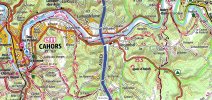
Now I see! Great map! Do you have the whole Via Podiensis in map form like that? Where would I find it to download? Thanks!
 
I did this route several years ago. The Cele variant often climbed up and over several ridges off road. However I found the country road that paralleled the river a much nicer pleasant stroll and so stopped following the official path. It’s more apparent when you’re actually there and this suggested variation doesn’t require any advance study.
 
Last edited:
3rd Edition. More content, training & pack guides avoid common mistakes, bed bugs etc
Now I see! Great map! Do you have the whole Via Podiensis in map form like that? Where would I find it to download? Thanks!
Just use the link above the map and then follow the pilgrim trail
 
Thanks everyone. Much more clarity now to what was confusing (to me ) before.
 
Hi Leigh,
I absolutely loved the Cele valley variant and reading the names of these villages/towns brings back great memories!
Your itinerary overnights are exactly the same as ours and they all worked well. Unfortunately, I can not help you with your question regarding your first stage. We had taken a taxi that stage; our only one since starting in Le Puy as my friend had twisted her ankle and worried about trying to walk that longer stage.
Tip- if time permits, stay two nights in Figeac so you can take the train to spend time in lovely Rocamadour; it was built into a cliff and very unusual.
 
Last edited:
...and ship it to Santiago for storage. You pick it up once in Santiago. Service offered by Casa Ivar (we use DHL for transportation).
Thanks so much. Your information is helpful. I am actually confused by the choices of alternate routes and maybe just need to read more carefully. But any recommendations that are less strenuous “ relaxing stroll “ along the river to Cahors sounds lovely. However I would take more strenuous choices in order to stay away from pavement. Is that what following the road after Archambal is? I think I read the climb to the train bridge is steep, on loose ground? Was it worth the shorter distance ? 2 km. Thanks again for your experienced reply.
Bonjour Leigh, after Arcambal it is best to follow the river path … not the road … in fact, I have never seen or thought of taking the road / pavement and I have walked this way a goodly number of times … mention of the road is really confusing because it it not necessary …
Hi Leigh,
I absolutely loved the Cele valley variant and reading the names of these villages/towns brings back great memories!
Your itinerary overnights are exactly the same as ours and they all worked well. Unfortunately, I can not help you with your question regarding your first stage. We had taken a taxi that stage; our only one since starting in Le Puy as my friend had twisted her ankle and worried about trying to walk that longer stage.
Tip- if time permits, stay two nights in Figeac so you can take the train to spend time in lovely Rocamadour; it was built into a cliff and very unusual.
Absolutely agree re Rocamadour‼️
 
Last edited:
Ideal sleeping bag liner whether we want to add a thermal plus to our bag, or if we want to use it alone to sleep in shelters or hostels. Thanks to its mummy shape, it adapts perfectly to our body.

€46,-
Thanks so much. Your information is helpful. I am actually confused by the choices of alternate routes and maybe just need to read more carefully. But any recommendations that are less strenuous “ relaxing stroll “ along the river to Cahors sounds lovely. However I would take more strenuous choices in order to stay away from pavement. Is that what following the road after Archambal is? I think I read the climb to the train bridge is steep, on loose ground? Was it worth the shorter distance ? 2 km. Thanks again for your experienced reply.
Which railway bridge are you referring to? The one at / near Bouziès?? It is easy to access from behind the former railway station at Conduché [now a bar-café-restaurant] … the scramble on loose ground is at the other end as you climb down to the river path and chemin de halage … pretty hairy now for me with my damaged knees, and that bit older, but I’ve done it a few times and never regretted it … love dat bridge
 
Hello everyone. As always I am thankful for the advice given here!

Please comment on my itinerary re difficulty:

Figeac - Espagnac -Sainte - Eulalie. 25.7 km. Cicerone says easy to moderate. Is it? I would like to walk this distance in one day if I can
Espagnac-Sainte-Eulalie. - Marculhac-sur-Cele. 15.9 km. “Strenuous”
Marcilhac-sur-Cele. — Cabrerets. 18.3 km. “Strenuous”
Cabrerets— Saint-Cirq-Lapopie. 10.9 km. “Strenuous”
Saint-Cirq-Lapopie - Pasturat 15.2km. Moderate if stay on GR36 ? stay on the GR36 not the train bridge route
Pasturat - Cahors 18 km. Looks relatively easy.

I am mainly wondering about the first leg of 25.7 km which I so want to do ( and barring injury I should be in reasonable shape coming from Le Puy en Velay. - although 70 yrs old. ). Your thoughts would be helpful.
Any suggestions on places of accommodation that you liked?
Is it worth staying an extra day in Cahors? Any other places?
Thanks again
An extra day in Cahors is very worthwhile … are you continuing on from there?
 
Hello everyone. As always I am thankful for the advice given here!

Please comment on my itinerary re difficulty:

Figeac - Espagnac -Sainte - Eulalie. 25.7 km. Cicerone says easy to moderate. Is it? I would like to walk this distance in one day if I can
Espagnac-Sainte-Eulalie. - Marculhac-sur-Cele. 15.9 km. “Strenuous”
Marcilhac-sur-Cele. — Cabrerets. 18.3 km. “Strenuous”
Cabrerets— Saint-Cirq-Lapopie. 10.9 km. “Strenuous”
Saint-Cirq-Lapopie - Pasturat 15.2km. Moderate if stay on GR36 ? stay on the GR36 not the train bridge route
Pasturat - Cahors 18 km. Looks relatively easy.

I am mainly wondering about the first leg of 25.7 km which I so want to do ( and barring injury I should be in reasonable shape coming from Le Puy en Velay. - although 70 yrs old. ). Your thoughts would be helpful.
Any suggestions on places of accommodation that you liked?
Is it worth staying an extra day in Cahors? Any other places?
Thanks again
after Saint-Cirq-Lapopie I would definitely stick to the official route to Pasturat … the alternative via the train bridge that is described in the Cicerone guide is pretty hairy and overgrown … I would be very surprised if any work has been done to clear it and make it more accessible …
 
The 2024 Camino guides will be coming out little by little. Here is a collection of the ones that are out so far.
Your stages match the ones I took. I don't recall any being "strenuous," but I had also started in Le Puy so was in trail-shape by then. I think it would've been harder if I had started there. There are lots of ups and downs, but nothing that is rugged or dangerous.

I didn't realize how good a shape I was in until the climb to St. Cirque. The trail passes by the car park for the tourists. I had just walked up from the river, a couple hundred meters ascent, without much trouble. The tourists were all winded by the tiny hill between the car park and the town.
 
Perfect memento/gift in a presentation box. Engraving available, 25 character max.
Hello Lorayne, if you follow the GR651 you will have approximate 285m up and 300m down on this 26km to Espagnac-Sainte-Eulalie.
The next day to Marcilhac-sur-Célé 500m up 522m down 17km
The next day to Cabrerets 565m up 560m down 19km
The next day to Saint-Cirq-Lapopie up 400m down 340m 11km
in 2017 I did the shortcut over a railway bridge over Le Lot to Saint-Cirq-Lapopie
The next day to Pasturat 400m up 450m down 16km
The last day to Cahors would be 440m up 480m down 24km if you stay all the way on GR36 but your route may be different probable you are following the road after Arcambal.
Hope this helps.
Regards Paul
I can't remember how I did go up to the railway bridge. I was 61j then and still in very good shape now.


Check out on this map Pasturat_CahorsView attachment 142998
Thank you for this map. I’m planning on walking the Cele variant again but this time backwards, from Cahors to Figeac. Does anyone have insight or recommendations about the markings?
 

❓How to ask a question

How to post a new question on the Camino Forum.

Most read last week in this forum

Hi there, I'm considering walking from Le Puy to St. Jean next spring if I can get my French up to par. I'm looking on advice on a few things: - Would it be too cool and rainy to start walking...

Featured threads

❓How to ask a question

How to post a new question on the Camino Forum.

Featured threads

Forum Rules

Forum Rules

Camino Updates on YouTube

Camino Conversations

Most downloaded Resources

This site is run by Ivar at

in Santiago de Compostela.
This site participates in the Amazon Affiliate program, designed to provide a means for Ivar to earn fees by linking to Amazon
Official Camino Passport (Credential) | 2024 Camino Guides
Back
Back
Top