- Time of past OR future Camino
- Some in the past; more in the future!
Both the Camino Torres and Caminho Português Interior go through Lamego and make their way through the vineyards of the Douro Valley before crossing the footbridge at Peso da Régua. There are two different paths - one for each camino.
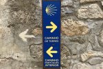
At Sande, about 5km from Lamego, there is clear way-marking signage pointing right for the Torres and left for the CPI:

This is somewhat counter-intuitive, because ultimately the Torres goes left (west) towards Braga while the CPI goes north towards Chaves. In any case, the two paths meet up again before the footbridge to cross the Douro River, about 5km later. Therefore, regardless of which camino you are walking, you can choose either of the two paths.
Since I have now walked both of them, my strong recommendation is to walk the Torres path. It might be a bit longer, but it is more scenic - and what amazing scenery it is! Both paths go through vineyards, but what makes the Torres path stand out are two things: the wild beauty of a gorge with olive trees and an old stone bridge, and the panoramic views back over the vineyards from the ridge after the gorge. The CPI path also includes a gorge, but it’s not as pretty as the Torres gorge, and way-marking is not as good on the CPI route.
If you do choose the CPI route, there is some confusion about the route. This is the Gronze entry:
My translation: Shortly after Pontão, in the final descent to Peso da Règua, instead of following the N2, which in high season has quite a lot of tourism traffic, there was a camino, currently not signed at the turnoff and cut off by a gate, that descended quickly to the Rio Varosa. We are pointing out its existence in case one day the route is recovered.
This is incorrect; the river camino still exists.
There is a fork in the road at the Rua do Pontão sign (41°08'06.7"N 7°46'49.4"W). It’s very clear that there are yellow painted arrows at this point turning right that someone has attempted to turn into yellow crosses. But this is not the turnoff for the river descent, which is a few hundred metres ahead. At this fork, both paths lead to the N2 and meet up again before the turnoff - we took the right path and had no problem with it but it really doesn’t matter which one you take at this point.
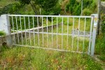
Later, at the hard right turnoff from the N2 for the river descent (41°08'26.5"N 7°46'40.3"W), there is indeed a gate. But walkers can easily go around the gate and arrows continue to point this way. This is the gate:

From here, it is a switchback descent (with arrows) on an overgrown road to the bridge and way-finding is straightforward. The bridge is high above the river and you never descend to the river itself. On the other side, way-finding is again straightforward and it isn’t far to the Douro River crossing.
Hopefully this is helpful for pilgrims on the Torres or the CPI! The Douro Valley is absolutely spectacular and is a highlight of both caminos.
At Sande, about 5km from Lamego, there is clear way-marking signage pointing right for the Torres and left for the CPI:

This is somewhat counter-intuitive, because ultimately the Torres goes left (west) towards Braga while the CPI goes north towards Chaves. In any case, the two paths meet up again before the footbridge to cross the Douro River, about 5km later. Therefore, regardless of which camino you are walking, you can choose either of the two paths.
Since I have now walked both of them, my strong recommendation is to walk the Torres path. It might be a bit longer, but it is more scenic - and what amazing scenery it is! Both paths go through vineyards, but what makes the Torres path stand out are two things: the wild beauty of a gorge with olive trees and an old stone bridge, and the panoramic views back over the vineyards from the ridge after the gorge. The CPI path also includes a gorge, but it’s not as pretty as the Torres gorge, and way-marking is not as good on the CPI route.
If you do choose the CPI route, there is some confusion about the route. This is the Gronze entry:
Poco después de Pontão, en la bajada final a Peso da Régua, en vez de seguir la N2, que en temporada alta tiene bastante tráfico asociado al turismo, existía un camino, actualmente no señalizado en la partida y cortado por una cancela, que bajaba rápidamente al río Varosa. Dejamos constancia de su existencia por si algún día es recuperado.
My translation: Shortly after Pontão, in the final descent to Peso da Règua, instead of following the N2, which in high season has quite a lot of tourism traffic, there was a camino, currently not signed at the turnoff and cut off by a gate, that descended quickly to the Rio Varosa. We are pointing out its existence in case one day the route is recovered.
This is incorrect; the river camino still exists.
There is a fork in the road at the Rua do Pontão sign (41°08'06.7"N 7°46'49.4"W). It’s very clear that there are yellow painted arrows at this point turning right that someone has attempted to turn into yellow crosses. But this is not the turnoff for the river descent, which is a few hundred metres ahead. At this fork, both paths lead to the N2 and meet up again before the turnoff - we took the right path and had no problem with it but it really doesn’t matter which one you take at this point.
Later, at the hard right turnoff from the N2 for the river descent (41°08'26.5"N 7°46'40.3"W), there is indeed a gate. But walkers can easily go around the gate and arrows continue to point this way. This is the gate:

From here, it is a switchback descent (with arrows) on an overgrown road to the bridge and way-finding is straightforward. The bridge is high above the river and you never descend to the river itself. On the other side, way-finding is again straightforward and it isn’t far to the Douro River crossing.
Hopefully this is helpful for pilgrims on the Torres or the CPI! The Douro Valley is absolutely spectacular and is a highlight of both caminos.


