
-
Remove ads on the forum by becoming a donating member. More here.
Search 69,459 Camino Questions
Camo's latest activity
-
CGoogle Maps and Ride With GPS allow you to make customizable route maps.
-
CThere are a number of apps that will allow you to import GPS tracks (,kml, ..gpx, etc.) to create maps like you see in the popular Camino apps. Popular apps of this sort include Organic Maps, Mapy.cz, and Wikiloc. There are a number of online...
-
CCamo replied to the thread Making A Map.The easiest way is to simply use "directions" in Google Maps but on your laptop to MAKE it and then "send to phone" to USE it - it will have the blue dots but also have the audio directions so you can simply put phone in pocket (and take a...
-
CI think it would be time to close this thread, it derailed days ago .🙏🏻
-
CHere's some of my thoughts on the drone topic. I think the drone thing is already overdone. Efron was still at the point of not being overdone, but anything more recent is. Secondly, I don't find drones annoying. The time I seen one on the...
-
CMost people are not, will not be aware of any drone other than commercial size in the vicinity due to ambivalence,backround noise and enviromental factors they will subconciously tune out the noise At 400 feet up you wont hear it in daytime...
-
CHeaven?
-
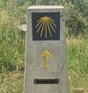
CCamo replied to the thread Kilometre markers.I meant point in the same direction as the ARROW - but never mind here is the final waymarker which IS pointing the right way
-
-
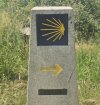
CCamo replied to the thread Kilometre markers.Well I am an even older engineer (called a greaser in the old days) of the mechanical type and my choice would be 2 decimal places but not sure when a decimal point became a comma? But my main gripe with this image is why does the shell not...
-
-
CCamo replied to the thread The REAL Camino Viejo - a new project for a Camino alternative..I actually tried an experiment of putting this section of the walk into my Web-App container (but without SatNav) and it is here https://camoapps.com/caminoinglis/trackcard3v.html The drone pano I sent to you is Pano26 and there is another one...

❓How to ask a question
How to post a new question on the Camino Forum.
Latest posts
-
 LIVE from the Camino Welcoming pilgrims at Arrés
- Latest: Juspassinthru
-

-
 LIVE from the Camino Lindsay’s Levante
- Latest: peregrina2000