• ⚠️ Emergency contact in Spain - Dial 112 and AlertCops app. More on this here.
  • Remove ads on the forum by becoming a donating member. More here.

Search 74,075 Camino Questions

HELP -- From the Puerto de Pajares to the Pueblo de Pajares on the Salvador

peregrina2000

Moderator
Staff member
As some of you know, I'm in the process of updating the Confraterity's online Salvador guide. I am pretty well done, but some recent comments have left me a bit confused about the segment between Puerto de Pajares and the Pueblo de Pajares. I apologize if this is extremely detailed and confusing -- probably only those who have walked the route recently will be able to understand what I'm talking about.

The Puerto de Pajares (which is the mountain pass, where there is an empty shuttered parador, a bar with good food, and great views) is about 5 kms along the N-630 highway to the Town of Pajares (where there is a great albergue, a Casa Rural, and a bar/restaurante). I do NOT recommend walking those 5 kms along the side of the highway. This is a very busy truck route.

In the old version of our online guide, these were the directions:

If you would rather escape the roaring traffic, follow the N-630
highway a half km or so from the Puerto until you spot an
emergency gravel stop lane for trucks with failing brakes, and a
sign that warns of a 15% grade descent. To your LEFT is a
marked Camino path, an overland alternative that is longer, but
much more pleasant and safe.

On page 35 and p. 36 of Ender's new guide in English, http://caminodelsalvador.net/?cat=13 he describes a way to get to that emergency warning without walking on the N-630 highway. This option seems to involve walking along a path on the RIGHT side of the N-630 for a while, dropping down to the N-630 at the point where the emergency warning is, crossing the N-630, and getting on the path we describe as being 1/2 km along the N-630 and off to the left.

When I walked the Salvador in 2012, though, I could have sworn that there is a new turn-off on the LEFT side of the N-630 not very far from the parador. In other words, I'm pretty sure that I didn't stay on the N-630 for that 1/2 km of death-defying traffic before getting to the turnoff on the left, but that rather there was a much earlier turn-off, which no doubt joins up with the path that the other two options are talking about.

Can anyone help me out here? I would really like to have clear instructions for this segment because the N-630 is very busy with trucks and would be extremely dangerous to walk on.

Thanks, everyone, buen camino, laurie
 
€2,-/day will present your project to thousands of visitors each day. All interested in the Camino de Santiago.
Laurie:

I thought this little area was called Arbus??? I ate in the little restaurant bar you described on a cold wet miserable day in April. Leaving the bar you walk up the highway and veer to the right. There you will come across a truck stop/park/pull off area. At the end of this lot there is a fence/gate that says Privado. You climb the fence and walk up a stone path along some electrical wires and the turn left where there is a gap in a barb wire fence. You then walk down a fairly steep slope back to the highway. I recommend you stay to the left. Once you reach the highway, you will see the Camino arrows on the other side of the road. This is only a short walk, less than a kilometer. Next time I would consider sticking to the highway in bad weather. The slope down is steep and very slippery in wet weather. Pajares is about 5 to 6km's from this point. If it is wet and raining this can be a very muddy slog the first couple km's. After that the walk is along narrow farm paths to Pajares.

Hope this helps.

Joe
 
Hi, Joe,
Thanks for this. I think you went the way that Ender's guide describes, since you describe a path on the right of the highway. It sounds like you came back to the spot of the flashing lights on the highway/ emergency truck pull off, etc. Your experience confirms that the original route we described will still work.

But I would swear I followed a camino turn-off on the left of the highway that was not so far along the N-630 as the one you and the orginal CSJ guide describe. I thought it was right after the parador. I'm assuming you didn't see that.

I also think that there is no good solution for bad weather walking. That descent on the Camino is dangerous and slippery in bad weather, but walking on the side of the N-630 is also dangerous in bad weather (or any weather for that matter).

Anyone else with a good memory out there? Thanks, Laurie
 
3rd Edition. Vital content training & pack guides avoid common mistakes, bed bugs etc
After a few more email exchanges, things are getting a bit clearer. Here is what I have now:

1. At the church of Sta. Maria de Arbas (where there is a meson), stay on the national highway. Although you may see trail markings just beyond Santa Maria (taking you off the highway to the right), ignore them, because this path will bypass the bar further on and involves some bad terrain and barbed wire. Stay on the road for approximately one km, when you will arrive at the Puerto de Pajares (Pajares Pass) with its bar and abandoned parador.

2. After the parador/bar/pass, stay on the highway for a short distance. This means that once again you will ignore arrows pointing you off to the right of the highway. Following the arrows here is, in the words of an Aug. 2103 pilgrim, "unpleasant and confusing." It will take you through bad terrain and barbed wire. If you stay on the side of the national highway, you will soon see the Camino marking on the left. Take it. This turn-off may be as much as 1/2 km from the pass but may be much less. Though there is a steep descent at first, it is a beautiful and well marked trail. Several kms along the way, you will see signs splitting the Camino -- to the right for Pajares and its albergue; straight ahead for San Miguel del Rio. There are no accommodations between Pajares and Campomanes, so most people will go into Pajares with its excellent albergue and welcoming bar/restaurante. You will not need to return to this point the next day because there is a well marked (and very beautiful) trail straight from the town of Pajares to San Miguel.

I know I tend to the wordy side and don't want to overwhelm the reader, but this is really the only slightly tricky spot left on the Salvador, I think.

Comments appreciated -- and if anyone knows the NAMES of the meson at Santa Maria de Arbas and the bar at the Pajares pass, please let me know so I can make this a bit clearer.

Buen camino, Laurie
 
I think it sounds good, it's easy to understand. I will be walking there in a month.
I wonder (as I've been reading the other thread too) if its best to walk on the left or on the right side? Is there a hard shoulder or can I walk in the ditch?
It sounded a bit scary having to look back for trucks all the time.
 
Hi, Susanna,
Thanks for your comment. I think it's always best to walk on the left side of a highway, unless you are coming to an extremely closed curve and can make it across safely till you've gotten around the curve.

My memory, though, (maybe others will correct me) is that on the road between Santa Maria de Arbas and the bar/parador, there is a dirt trail on the right side removed from the actual highway. This one km is totally flat, has lots of big open spaces for parking lots and the like and will be easy for you to get to the pass a km down the road.

When you walk next month, would you mind helping my memory on where the turnoff is after the pass? Do you have to walk 500 m on the highway till you get to the emergency pull-off/flashing lights (where there is definitely a turn-off) or is there now also one much closer to the parador parking lot?

Thanks again, we're getting there! Laurie
 
Get a spanish phone number with Airalo. eSim, so no physical SIM card. Easy to use app to add more funds if needed.
Thank you Laurie. I always walk on the left side, but I was wondering about this part as Gunnarw wrote this in the other thread:
" To continue to Pajares: or go back to the silo and follow the arrows, or walk carefully during 700m on the N630 on the right side as there is absolutely no walking space at the left side. At every curve, look behind for approaching trucks. Only walk in a curve if you notice no traffic. Walk till the emergency stop."
Is that the same section you have written about above?

Yes of course, I will take notes of how it looks there.
 
Hi, Susanna, Gunnar's notes confused me, and I think he is still on vacation so I haven't emailed him. I am sure we are both talking about the same part of the N630 -- the 500 m or so between the actual pass of Pajares and the Camino turn-off (or one of the turn-offs). This brings me back to my earlier confusion about where the turn-off on the LEFT side of the road is -- is it about 50 m as my vague memory suggests? or is it 500 m near the emergency stop/flashing lights/ signal of steep grade, etc? Or are there two turn-offs? In any event, my advice would be to stay ON the N630 between Arbas and the pass, and to get OFF the N630 by following the first Camino marker you see to the LEFT, whether it's 50 m or 500 m from the pass. And I guess I'll just say in the guide to be careful with the narrow road and leave it to the pilgrim to decide whether to get on the left or right side of the highway.

Buen camino, Laurie

p.s. to make things more confusing, note too that Gunnar says in his notes that there is a sidewalk alongside the N630. I wouldn't know because I've never walked all the way (5 kms more or less) along the N630.
 
Thank you Laurie.
Ok I googled n-630 and Pajares and I found this film on YouTube:
It's a film where they are driving on the n-630, it should be that section, I hope.
If we are lucky, maybe we can se the difficult part on the film.
 
Fail to prepare? reduce your risk by buying this book full of practical info.
2nd ed.
Hi, Susanna, This is GREAT -- the only thing better would have been if they were going in the opposite direction. But here's what I see going "backwards" from the town of Pajares (at about 2:30 into the tape).

2:28 -- turn-off on the R is where you leave the highway and get on the Camino to San Miguel
2:35 -- the road on the right is where you will join the highway coming from the albergue
4:06 -- sidewalk ends. Gunnar's comment about there being a sidewalk on the right side of the road is correct, but it doesn't seem to extend too far, meaning that if you stay on the highway you will have a bunch of kms on the shoulder till you reach the sidewalk.
Around the 8 minute mark is where you can clearly see the turn-off on the Right near the emergency path on the other side. I think I pretty clearly saw a camino mojon at 8:04 in the lower right hand corner. That is the turn-off the guide originally described as "500 m along the N630 from the parador, at the point where there are emergency lights flashing and warnings of steep grade and an emergency pull off for trucks whose brakes are failing."

At 9:39, right at the foot of the abandoned parador, I THINK but am not sure that that is where there is now a Camino trail marker. That would keep you off the road for the distance between 8:04 and 9:39. But I am just not sure.

One thing is clear from this tape -- Gunnar is absolutely right that after the parador, if you are on the N-630 you will have to be on the right because there is absolutely no shoulder on the left (which is actually the right on this tape).

I'll take another look, but I'm now two minutes late for a meeting! Buen camino, Laurie
 
Hello,

I just watched the N630 movie.
For your info: the hotel in Pajares is at 2:40 on the left side (brown house with some red around the windows). There is no big advertissement. You could miss it.
4:06 yes, side walks ends (begins)
4:42 the camino at the right side joins the N630. In between you have a parking area to enjoy a view over Pajares. As you can see, it s not a big deal to walk on the N630 till the side walk starts.
8:04 yes, the camino at the emergency track. Normally there should be the path at the right that ends there that was starting at the silo at 9:55.
9:39 well, I m not sure that there was a marker there to shortcut the N630. I think it was just a camino marker to inform the drivers.
I just looked on a picture I took there and the front of the marker is not visible on my picture. Susanna must resolve this issue :)
9:55 the silo: there is a big sign saying PUERTO ABIERTO (green) or closed when there is too much snow. There is also a yellow arrow pointing to the LEFT in the movie bypassing the bar/parador and normally should join at 8:04

In fact to come back to 9:39. My room here in the hotel is quite far away from the internet PC (and I could miss my chair :)) . I can check later on my navigator that has a topomap of Spain if there is a path at 9:39 that joins the path at 8:04
I can already confirm after a few hundred meters on the path at 8:04 there is a split with another direction. It could be that this is a shortcut with 9:39.

For your info: we walked on the N630 from the church at ARBAS DEL PUERTO on the left side till the bar/parador. Half way, there is a separate lane on the right side till the silo that is much safer (but lesser nice to film, you will see later). We continue on the right side on the N630 till the emergency track.

I hope my explanation is clear because English is my third language and it could be possible that I sometimes miss something.

Susanna can also note the telephone number to buy the parador.
It could be 902 860 861 :)
Susanna, I hope you will have a clear view to admire the wonderful Asturian mountains because when we came back with the bus, it was all under the clouds. The view at the Parador is the climax of El Salvador !

UPDATE: the name of the bar on Alto de Pajares is VENTA CASIMIRO. They have a sello.

Till soon,
 
Last edited:
Thanks for the update, Gunnar -- perfectly easy to understand and native-sounding! I'm wondering why you chose to walk along the highway instead of taking the Camino option into Pajares. Buen camino, Laurie
 
Fail to prepare? reduce your risk by buying this book full of practical info.
2nd ed.
Hola Laurie and Gunnar! Thank you so much, it's very helpful.:)
I've been looking at everything again and compared it with this map on google earth:
http://pilgrim.peterrobins.co.uk/routes/details/salvador.html

Just checking so I got it right. After Arbas del Puerto, I better stay at the highway, all the way to a couple of hundred m something after the Parador. There I take left. From there it's all camino to Pajares. No need to get up to the highway again before that?

(I been googling the Parador. Will think about it. I always wanted a palace;))
 
Susanna, I was thinking it would make a great albergue for the pampered pilgrim!

Just a quick note about Peter Robins maps -- He lists "Rodiezmo - Pola de Lena" as one of his maps. The Salvador does not pass through Rodiezmo, if you arrive in Rodiezmo it means you have missed the turn-off at the water hut on the way down after your ascent from Buiza. !!!
 
Hello,
I m back again.
I checked the Garmin topomap of Spain. There is no path to the left just (a few meters) after the parador. For your info: there is a railroadtunnel and you will see it coming out when you are on the caminopath a few hundred meters after the emergencytrack.
I asked my wife. She is also for 90 percent sure that there is no caminopath just after the parador.
So Susanna, if there is no caminopath: 2 options: Return to the silo and bypass the N630 to the right or take the N630 carefully till the emergency track. I took the N630 because I was pulling a cart and it was easier to follow the N630 for a few hundred meters.
 
3rd Edition. Vital content training & pack guides avoid common mistakes, bed bugs etc
I quickly checked the Peter Robins map at the Parador and zoomed to maximum.
There is also no path just after the Parador on that map. On that map, there is only marker K87. You will see also that the source Reguero del Puerto is in that area.
 
Ok Gunnar & Laurie,
If there isn't any way to the left just after the Parador, then where is it? Am curious.:)
So, I started the Google maps app at my iPad.
Then searched for Parador Pajares, which I found, and they also got street view out there!
So I started to walk in street view from Parador towards Pajares.
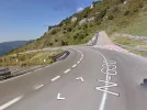
And after say a few 100 meters I took this screen shot:
There's a camino stone (or what do they call them) to the left.
Is that the way where one goes to the left?
 

Attachments

  • image.webp
    image.webp
    130.4 KB · Views: 36
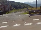
....and here is a screen shot of google maps street view pic just after the Parador. :)
Please note, there's a hole in the fence.
Maybe there is where one can turn left to avoid the highway?
(This is fun:))
 

Attachments

  • image.webp
    image.webp
    123.1 KB · Views: 42
Ideal sleeping bag liner whether we want to add a thermal plus to our bag, or if we want to use it alone to sleep in shelters or hostels. Thanks to its mummy shape, it adapts perfectly to our body.

€46,-
I'll probably be past that point by this time in two weeks. This thread has been very helpful, thanks so much for discussing it out in the open rather than by email/PM!

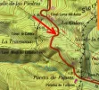
Just to confirm from Gunnar's explanation, I should stay on the left from Sta Maria de Arbas until the bar at Pajares then cross on to the track on the right until the descent at the gravel area? Is that right? Just for my own interest, is the track down from the N630 the one on the map I've highlighted (black broken line just before the power line, headed west and following the ridge along the valley)?

If I am doing OK for time I will have a look around the parador for any chance of an alternative route.

Cheers,

Stuartmap.webp
 
Ok Gunnar & Laurie,
If there isn't any way to the left just after the Parador, then where is it? Am curious.:)
So, I started the Google maps app at my iPad.
Then searched for Parador Pajares, which I found, and they also got street view out there!
So I started to walk in street view from Parador towards Pajares.
And after say a few 100 meters I took this screen shot:
There's a camino stone (or what do they call them) to the left.
Is that the way where one goes to the left?

Susanna, this is the turn-off that is 500 m from the parador. Do you see the emergency truck lane on the right?
 
....and here is a screen shot of google maps street view pic just after the Parador. :)
Please note, there's a hole in the fence.
Maybe there is where one can turn left to avoid the highway?
(This is fun:))

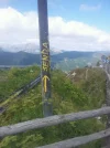
And BINGO -- there IS a camino path from right in front of the parador. If you enlarge the image, you can see arrows on the pole!!!! This is the way I went in 2012.

The earlier picture is the way I went in 2010. Does this make sense to anyone but me?
 
Ideal sleeping bag liner whether we want to add a thermal plus to our bag, or if we want to use it alone to sleep in shelters or hostels. Thanks to its mummy shape, it adapts perfectly to our body.

€46,-
I'll probably be past that point by this time in two weeks. This thread has been very helpful, thanks so much for discussing it out in the open rather than by email/PM!

Just to confirm from Gunnar's explanation, I should stay on the left from Sta Maria de Arbas until the bar at Pajares then cross on to the track on the right until the descent at the gravel area? Is that right? Just for my own interest, is the track down from the N630 the one on the map I've highlighted (black broken line just before the power line, headed west and following the ridge along the valley)?

If I am doing OK for time I will have a look around the parador for any chance of an alternative route.

Cheers,

StuartView attachment 5912

Hi, Stuart. I think the important thing between Sta Maria de Arbas and the bar at Pajares is to stay on the side of the N-630, whichever side is better to walk on (I have a vague memory of walking on the right).

And I am afraid I am helpless with maps, so I can't tell you what that map says, but Gunnar is very good with maps, so we'll hope he gets back on to comment on this. Buen camino, Laurie
 
And BINGO -- there IS a camino path from right in front of the parador. If you enlarge the image, you can see arrows on the pole!!!! This is the way I went in 2012.

The earlier picture is the way I went in 2010. Does this make sense to anyone but me?

Good!
I should be sleeping by now, but had to google as I wanted to see what that path looks like.
Ok, here is a pic of the ground in front of the Parador:
http://www.flickr.com/photos/silviayjuanjo/2471133365/sizes/l/in/photostream/

And from far away, scroll down to pic 29:
http://pelescaleyes.blogspot.se/2009_05_01_archive.html

So indeed it looks like a path, very steep hill down the way, though. But it's gotta be better than the highway.

Edit: ok here comes the best and the final (I promise) pic of the parador-camino:
http://www.flickr.com/photos/958332...qGs-6yPCeK-e6gEP6-6yPDzg-6yPDHB-6Gnq1N-6yPDpc
 
Last edited:
Laurie,

no worries, maps, particularly Spanish maps, aren't the easiest to understand. I work with maps every day so take them for granted. But I think Susanna's picture has answered my question anyway, it looks to be the same place as I can see the power lines in the background.

I'll definitely be having a poke around the Parador area now as it does indeed look like a yellow painted arrow and shell on the post by the fence in that photo.

Thanks, all. Eight days until I leave now so very excited!

Cheers,

Stuart
 
Before the Camino: Your Pocket Guide to Prepare Your Body and Mind for the Camino
;) Guys, you're great!!!
This was like reading a detective novel. I'm sure I'll remember this conversation when (hopefully) walking Salvador next year!

Ultreia!
 
Ok, Stuart, you're the guinnea pig. I can't wait to hear what happens once you get to the parador.

And I just wanted to say that I really appreciate everyone's help here. The Salvador is a stunning camino, but it is a very solitary route, and having some level of assurance and specificity with the route's "problem spots" makes a big difference, especially to those who walk alone. The arrows and markings Ender has installed have tremendously improved things, and now that we have this spot more or less resolved, I think the Salvador is good to go for anyone who gets to Leon and says -- this is too crowded, I think I'll go north to the Primitivo from Oviedo. The Salvador is a very fine way to get there on foot!!

Buen camino, Laurie
 
I love that it can be resolved collectively like this too and that so many people have put in so much effort for everyone else for rewards that aren't easily defined. Anyhow, thanks everyone for the info. If there is anything I can contribute on my return then I'll certainly do my best.
 
€2,-/day will present your project to thousands of visitors each day. All interested in the Camino de Santiago.
Hi, Joe,
Thanks for this. I think you went the way that Ender's guide describes, since you describe a path on the right of the highway. It sounds like you came back to the spot of the flashing lights on the highway/ emergency truck pull off, etc. Your experience confirms that the original route we described will still work.

But I would swear I followed a camino turn-off on the left of the highway that was not so far along the N-630 as the one you and the orginal CSJ guide describe. I thought it was right after the parador. I'm assuming you didn't see that.

I also think that there is no good solution for bad weather walking. That descent on the Camino is dangerous and slippery in bad weather, but walking on the side of the N-630 is also dangerous in bad weather (or any weather for that matter).

Anyone else with a good memory out there? Thanks, Laurie

Laurie:

I actually ate at the Meson in Arbus. I then walked up the highway staying to the right. You then come to a long parking lot. At the end of the parking lot on the right is a gate that says Privado. I climbed over the gate and walked a short distance on a stone road to an electric tower and crossed over a section of a downed barbed wire fence. Then it is down a steep slope to the highway. If you stay to the left side of the slope, when you reach the highway the path to Pajares is just across the highway. I believe I walked behind the Parador/bar you speak about. If you walk the highway from Arbas, the turnoff to Pajares is on the left side of the highway after the closed Parador and before the truck runoff. Even though I stayed to the right and walked off road, I had to cross the highway and enter the path to Pajares on the left side off the road going North.

Hope this clarifies things.

Joe
 
Hi, Joe, based on what you describe, I think you took Ender's route -- stay on the right side of the road, went up to the tower, down to the highway, cross the highway and head onto the Camino. The route I took was at the place where the parador is on the left side of the road and the bar is on the right side -- there is a little path down, but it meets up with the path you took further on, if that makes any sense. Thanks for this, it looks like there are several ways to get to that path on the left side of the highway, so good luck to everyone heading out! Buen camino, Laurie
 
For anyone who is not sick to death of this topic, here is the language I propose to put in the guide. If it seems confusing or incorrect in any way, please let me know. I know it has a tedious amount of minutia, but it is a confusing place. Thanks everyone, Laurie

Sta. Maria de Arbas del Puerto (approximately 8 km from Rodiezmo on the highway option and 9.3 km over the mountains from Poladura de la Tercia). In Sta. Maria de Arbas del Puerto there is a beautiful Romanesque church and former pilgrim hospital, with sello. Sunday Mass at 1 p.m. This church was undergoing emergency restoration work in 2012. If the meson across the road is open, you may be able to obtain the keys there if the church is closed. There is also a fountain for refilling water bottles.

From Sta. Maria, the “official” route (as described on pps. 35-36 of the guide at caminodelsalvador.net) goes to the east (right side) of the highway, but it is not well marked, it is populated by bulls and barbed wire, and it bypasses Puerto de Pajares with its welcoming bar. Most people just stay on the side of the highway for that one km, to arrive at the mountain pass, the Puerto de Pajares. If you do want to take the off-road route, you can detour down to the bar at the Puerto de Pajares and return after having your break.
The Puerto de Pajares is the dividing line between Leon and Asturias. This is not a town, just a mountain pass; the town of Pajares is further on. The pass offers up beautiful views and a family-run bar on the east (right) side of the road that serves sandwiches and full meals. That establishment is closed on Mondays. There is a now-closed Parador on the west side of the highway (for sale in 2013), and its parking lot is a popular stopping-place for travelers and truck drivers.

Leaving Puerto de Pajares, you have three options.
1. You can stay on the side of the N630 for 5 kms to the town of Pajares. This is NOT recommended because there is very little shoulder, and you may find a lot of truck traffic. The last kilometer or two has a sidewalk, but the rest does not and you will have to walk on the right side of the highway, because the left side has absolutely no shoulder in many places.
2. From the bar on the right side of the road, you can find your way to return to the marked Camino. One pilgrim from August 2013 found this alternative “difficult and confusing.” Overgrowth, barbed wire, etc. You will ascend and then descend to the N-630 at the point where there are flashing lights and a “runaway truck pull-off.” Cross the N-630 and you have a steep rocky descent to verdant pastures and bucolic scenery. (A variant of this option would be to stay on the N-630 for 500 m from the parador – when you come to the flashing lights, take the turn-off on the left and continue; this has the advantage of avoiding the overgrowth and barbed wire, but has the disadvantage that you are on the side of a busy highway for 500 m.)
3. Right in front of the parador (which is on the left side of the N-630) there is a pole with a yellow arrow. It takes you off road immediately. One of us took this route in June 2012 and it joins up with alternative number two after the initial descent. From google street view pictures, it was not clear whether the path was open, but the arrow was clearly visible.
 
Before the Camino: Your Pocket Guide to Prepare Your Body and Mind for the Camino
I'm not tired of this thread yet. :)
I've ben reading it and it looks great. Maybe, if one wants to be ever more clear, one could add something about that alternative no 3 means ones walks at the west side (left side) of n-630.
(As you mentioned earlier that the official route goes to the east side)
It will be a great guide book. I'm looking forward to read all of it. :)
 
Hi, Susanna,
Thanks for the suggestion. When are you leaving? Should I send you the most recent version or wait till next week when I have it done? Laurie

Hola Laurie,
I'm leaving on Friday the 13th September, so next week will be fine. Will be fun to see it!
Just three weeks and six days to go then I'm off to walk with the new super duper guide!:)
Thank you so much!
Susanna
 
Fail to prepare? reduce your risk by buying this book full of practical info.
2nd ed.
Maybe, if one wants to be even more clear, one could add something about that alternative no 3 means ones walks at the west side (left side) of n-630.
(As you mentioned earlier that the official route goes to the east side)
It will be a great guide book. I'm looking forward to read all of it. :)

I apologize for bringing this up again, but I am at the final stages and want to make sure I have every little detail right before I transfer it over to Rebekah for her final polishing.

I was reading your comment again, this time more carefully, Susanna, and I think that maybe I didn't explain the alternatives clearly enough based on what you said.

Perhaps the best way to think about this stretch is not from the Puerto de Pajares to the Village of Pajares, but from Sta. Maria de Arbas to the Village of Pajaes.

Then I would divide that route into two sections, each of which has alternatives.

For Sta. Maria de ARbas to the Puerto of Pajares, you have two options:
1. Take the marked Camino, which is on the right side of the N-630 but goes away from the road.

2. Walk on the side of the N-630 in the safest manner possible to get to the Puerto de Pajares, with its bar on the right and parador on the left.

Then continue on to the three options for leaving the Puerto de Pajares. (In other words, my point here is that to walk alternative no. 3, you can be on either side of the N-630 till you get to the bar/parador/pass, the only important thing is not to take the marked camino, on the right side, which takes you away from the highway. Then, at the parador, the turn-off is on the left).

Any final thoughts????? Buen camino, Laurie
 
Ok I've been reading it again. It sounds good!
My suggestion to add that alt no 3 goes to the left of the highway is based on the fact that I haven been there yet. And as I saw the photos I could imagine myself looking down the slope thinking uh oh, are we really going down that hill?
So that's why I thought it would be fool-proof to say that from puerto de Pajares alt 3 means you are really walking on the left side of the road.
Hope this make sense. ;)
Don't worry. I'm not tired of it yet.:)
 
Thanks, Susanna, I've changed it to incorporate your thoughts. It's so great that there are at least three forum members heading out to the Salvador within the next couple of months, so I'm hopeful that there will be refinements and updates soon after their return!

After I receive one more set of comments, I will be DONE!!! (At least until you guys come back and tell me how I can improve it :-) )

Buen camino to everyone starting out on the Salvador. Though this thread was kind of tedious and boring, the Salvador is anything but tedious and boring. The scenery is amazing! The little villages are bucolic! The pre-romanesque is beyond belief ! (ok, I know that last comment has limited appeal). Laurie
 
€2,-/day will present your project to thousands of visitors each day. All interested in the Camino de Santiago.
Here is a message just posted on the Spanish forum in response to my question about the Salvador near the puerto de Pajares. Translation is mine:

"I walked this route a week ago, and I stayed on the highway, because a week earlier someone told me that the route from the turn-off was closed by a gate. So, with my wife, we stayed on the highway down to the town of Pajares -- we had to walk on the right side on the lane for slower moving vehicles, with no sidewalk and with a steep descent, and we had a ***** of a time (bad word deleted). We were waving at the many trucks and cars all the time to ask them to move over out of the lane we were walking in. Bottom line - I wouldn't recommend this alternative for anything. Later it turned out that the turn-off was open because the barrier had been broken."

Just one more voice in favor of staying off the N630 from the pass to the town. I guess I'm trying to brow beat you all into submission on this point. :-)
 
Just to muddy the waters again, I was checking something on the Wise Pilgrim website and spotted this for the section from Puerto de Pajares:

The Puerto de Pajares is one of the few mountain passes which for centuries has offered passage over the mountains into Asturias from the meseta. It remained the primary corridor until the construction of the A-66 to the West. It remains a difficult road for drivers and snow is not too uncommon here in June.

Although still popular with secondary traffic and locals, most of the business here has been shuttered; including a former alpine Parador National that looks over the valleys to the North.

The village of Pajares is downhill from here, but you are advised to stay off of the road. Instead, follow it just a short way and turn to your left (information board). [My emphasis] This trail proceeds to San Miguel del Rio, and if you have no intention of stopping in Pajares you can skip it altogether

I'm just wondering if this turn at the info board is the turn at the emergency lane or if this is referring to an earlier turn off the N630? It reads like it is closer to the parador.
 
Hi, Stuart,
I agree with you, it surely doesn't sound like someone who had to walk 500 m on the highway to the emergency pull-off. So thats at least one more voice that suggests the way from right in front of the parador is open! With so many forum members setting out soon (well, at least two or three), we'll soon have the right answer. Can't wait, but I wish I were walking this route again soon. Laurie
 
A great book to listen to while training for the Camino or to relive the experience!
Well as promised I said I would have a look and post back.

As Laurie suggested, there is indeed a path from the parador to the turn off for Pajares/San Miguel which follows along outside and below the N630.

Here is the downside... you need to be a lot braver than me to walk it. I am not afraid to say I was too chicken to try.

At the viewpoint beneath the hotel there is yellow painted signage and arrows for Pajares. But in BIG letters it says both DANGER and SENDA PELIGROSA. I thought at first it meant walking down the N630 was dangerous but after a couple of attempts at the path... I know what they mean. From the viewpoint there is a concrete drain that drops to about a couple of metres below the level of the road. From there is an obvious path which follows the contour of the slope. It looks easy but it runs out after maybe 20m. The real path is actually a bit below this and I could not find a safe way down to it. There is a near vertical drop on the left and the path doesn't look wide enough to get both feet on at once. In short, it looks VERY risky, and carrying a backpack and being tired after the crossing from Poladura it really was not for me. I must have spent maybe an hour trying to work the route out and gave up because the path I think it is just looks seriously risky. I personally would not advise anyone to take it. In fact, the opposite.

The offroad route to the east, behind the bar, is actually an OK route. Yep, you go through a field of cattle and in the mountain tradition the bull lives in the field. He kept his eye on me but the track climbs out of the field very quick and he looked like his mind was on other things :)

It is well marked and obvious. Go up to the the electricity pylons at the summit, a marker points to the left but you really don't need it. You can see the escape lane and the turn off for Pajares/San Miguel below. There is a barbed wire fence, I chucked my pack over and climbed under it. Very easy to pass. The route from here is not marked but again, very obvious. DOWN! It doesn't matter, it is very steep, just find the best way down you can. I was prepared for a bit of an epic section but it was surprisingly simple. I wouldn't hesitate to recommend it over the other two options. I've got pictures that I'll upload when I get a chance.

Hope that clears it up a bit.

Regards,

Stuart
 
Wow, Stuart, thanks for that. Susanna will surely benefit from this info. I am NOT a "brave" or reckless walker, and I just cant figure out how I could have done that path, but I am sure I did because just by process of elimination I know I didn't walk on the N630 and didn't walk on the path on the right side of the N-630. So I can't explain it. I am certain I didn't experience any of what you describe, so I guess I will just have to go back next year to clear this up in my own mind! Your descriptions have brought a return to the Salvador/Primitivo right to the top of my wish list.

And about the cattle -- I have been assured by many Spaniards that there are no "vacas bravas" in the fields because it would put the owner at too great of a liability risk. Of course, knowing your heirs can sue the owner if the bull kills you isn't much consolation. Can't wait to see your pictures, and thanks again for the help on the Puerto de Pajares puzzle. Laurie
 
Dear friends,
Thank you for all info about the Parador route!
Still, I'm going to walk it. There's no way in **** I'm going to jump over barbed wire fences to be chased by a bull. Don't fancy the serpentine road full of trucks either.
Been doing some more googling here.
The result:
https://plus.google.com/app/basic/p...photos&sparm=cbp%3D19gsdjlsdw1q7%26sview%3D20
Hope the link works.
It's a bunch of kids and their teacher on a day out, and they're walking the Parador route.
If they can do it, I can do it. :)
 
A great book to listen to while training for the Camino or to relive the experience!
I think for me the big trouble was not being able to find a clear start to the right path. It all looked quite risky scrambling especially with a rucksack on. If you can work out the proper way down then the track shouldnt be that hard. The big yellow danger signs put me off too.
 

Attachments

  • uploadfromtaptalk1378107453967.webp
    uploadfromtaptalk1378107453967.webp
    74.5 KB · Views: 32
  • uploadfromtaptalk1378107497802.webp
    uploadfromtaptalk1378107497802.webp
    72.8 KB · Views: 31
Thank you Stuart, for posting the pics.
Ok there's no lack of arrows there.
The question is, what do they mean. If I was standing there now, I would think I should walk along the road ten meters or so, and then jump over the fence. It looks like a path at the right of the arrow in the middle.
But the kids did turn left just after the parador...hmmm.
Can't wait to find out.
Looks like you were lucky with the weather!
 
Por aquí hay vacas y algún buey. El toro, el que embiste, se cría en el sur de España. Sería muy muy raro que una vaca te embistiera.

Over here there are cows and a bull (buey, no toro). The bull, the onrushing, grows in southern Spain. It would be very rare for a cow rammed you.
 
A selection of Camino Jewellery
The path you mention is the one I took. The arrows looked like they indicated you went over the barrier and followed the track you can see. It looked promising but ended very quickly at the concrete retaining wall for the road. The wall was wide enough to walk on but then got very narrow.

Maybe there is a way down to the left of the parador. I looked for it at the time but it is hard to get a good view of the slope. There are goat tracks all over and one looked promising. But it went over a rocky section with sheer drop. As I was on my own I didnt feel that brave. The path is obvious at the other end where it joins the track to Pajares. If I hadn't spent so much time there I would have followed it back up to the parador to see where it comes out.

I feel defeated by a bunch of school kids now :)

Good luck, let us know how you get on!
 
Stuart, I have to believe that for some reason you just didn't see an alternative way to get to that path. I can assure you that I never experienced anything like what you described, so don't feel defeated. ;) After all you did brave the loose cows and bulls and all the barbed wire.

Susanna, no pressure here, but you now have the responsibility of clearing this all up and finding the best way onto the path to Pajares! And remember, in a pinch, angulero assures us that it would be very "unusual" for one of those cows to ram you! Somehow that's not too comforting.
 
Fail to prepare? reduce your risk by buying this book full of practical info.
2nd ed.
Laurie, I'm not only going to walk that way, I'm going to film it. :cool:
And, when I'm standing there outside the Parador, I will take a right now- pic and post it here!
Am hoping it will not be too foggy. :)
 
Stuart, I have to believe that for some reason you just didn't see an alternative way to get to that path. I can assure you that I never experienced anything like what you described, so don't feel defeated. ;) After all you did brave the loose cows and bulls and all the barbed wire.

To be honest, I never really paid the left hand side much attention. All the yellow arrows and markings were on the right so when I couldn't see any way on I had already decided to take the "bull" route so just gave the left side a cursory examination. What was weird is that I am pretty sure that in one of the pictures posted in the thread you can see a yellow marker on the parador wall.

I think I made a pretty entertaining sight going up the hill past the bull, I remember thinking my poles were going so quick I probably looked like Franz Klammer at his prime :D

Good luck, Susanna! No pressure now :)
 
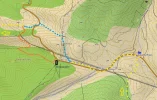
Here is a map I retreived from the latest Topographic map of Spain v5 from Garmin.
I dotted the map.
There should be a path at the left side of the Parador. This path was not on v4.
It goes steeply down, every brown height line is 20m. After -100m, it seems to follow a spring (fuente).
If I understood well, Stuart tried and the school kids did - follow a trail somewhere above the rail road (gray). The rail road is in a tunnel and comes out for 100m somewhere where the orange dotted path is very close to the rail road. I remember two people waving at us when we were at the place where blue, yellow and orange are joining.
If I understood well, Stuart took finally the blue path.
I took the orange N630 and continue with blue and yellow.
What Laurie did a few years ago is still a mistery.
Susanna, now it's up to you to clarify. Film the whole thing and don't forget to enjoy the Asturian mountains.

puerto-de-pajares.webp
 
Give back to the Camino. Join us from Logroño to Burgos May 30 to June 8.
Gunnar, that is wonderful! Thank you! Now I can't go wrong. I'm very grateful for this.
And what a great map! Wow! Now I'm jealous.
You got to have a special GPS or a Garmin app (very expensive) to buy these maps, or how is it?
 
Hello Susanna,
I bought the Garmin ETREX 20 for 159€. Small equipment but very clear display.
And you need Topomap Spain. But you can find on internet all maps of Europe for free (openmtbmap.org) but they have not all the walking trails on it.
All maps can be displayed in the free software Basecamp (or older Mapsource). That's how I made this screenshot and used "Paint" to put some dots and notes.
 
That's intetesting, Gunnar. The orange trail looks like it is a lot lower down the hillside than I was looking. Also where the track to Pajares leaves the N630 there was a path following the road which joined it immediately on the left. The orange path seems to join a lot further down. You are right, I took the blue path. Not particularly difficult but probably the longer of the three options.
 
Before the Camino: Your Pocket Guide to Prepare Your Body and Mind for the Camino
hee hee hee, this is the thread that never dies. Gunnar, your map is amazing and I sent it to REbekah to see if it's possible to squeeze it into the latest version of the CSJ guide. I am pretty sure I took the orange path without the death-defying features Stuart described, but yes I'm also mystified about my path. And we still need to see what Susanna has to say about all of this. In any event, all of this discussion has led me to the tentative decision that I will be back on the Salvador/Primitivo next year! Buen camino, Laurie
 
Hello Laurie,
Good idea to walk another time the Salvador and continue with the Primitivo.
I have some other interesting issues that I will post from time to time. So it's possible that you will get a little bit homework to take with you.
To be continued.
 
Ideal sleeping bag liner whether we want to add a thermal plus to our bag, or if we want to use it alone to sleep in shelters or hostels. Thanks to its mummy shape, it adapts perfectly to our body.

€46,-
Rebekah can be very happy I can't change my ticket.
Otherwise I would be there already, jogging up the mountain to beat her to it. ;)
 
Perfect memento/gift in a presentation box. Engraving available, 25 character max.
Oddly enough, I'm really enjoying this thread!
And Rebekah......even if we can't stay with you, I'm definitely stopping by to say HI. What, between your comment above and your delightful self-absorbed air of Pilgrim Planet comment on your blog, I've just got to meet you! I don't feel like one of those pilgrims who goes out to find themselves and answer the questions of the universe - we went for a walk with our family last year and will be doing it again with some of them to raise some money for wells in Africa next year. We don't fit that "pilgrim mold" - we've already decided to live simply (and consciously try to do so - just last week we ate UN rations for refugees so the kids could experience what it is to be in need), we already try to practise the presence of God in all we do, we are learners for life who don't need a walk to learn from (although we will learn something coz we are learning all the time).....I'm really looking forward to meeting you!
 
OM_SCREENSHOT.webp
Hola Laurie, as you can see on the attched screenshot of an electronic map you can walk on both sides of the caretera. The official camino stays on the right but you can walk also on the left side goin northbound, for about 500 meters and then join the camino again. If you chek on google maps you will see photographs of the left side path .
Buen camino
Brandy
 
A great book to listen to while training for the Camino or to relive the experience!
Laurie,

no worries, maps, particularly Spanish maps, aren't the easiest to understand. I work with maps every day so take them for granted. But I think Susanna's picture has answered my question anyway, it looks to be the same place as I can see the power lines in the background.

I'll definitely be having a poke around the Parador area now as it does indeed look like a yellow painted arrow and shell on the post by the fence in that photo.

Thanks, all. Eight days until I leave now so very excited!

Cheers,

Stuart
Stuart, could you let us know? I walk it in September and any more information would be great. Oh and by the way have a great Camino.
 
hee hee hee, this is the thread that never dies. Gunnar, your map is amazing and I sent it to REbekah to see if it's possible to squeeze it into the latest version of the CSJ guide. I am pretty sure I took the orange path without the death-defying features Stuart described, but yes I'm also mystified about my path. And we still need to see what Susanna has to say about all of this. In any event, all of this discussion has led me to the tentative decision that I will be back on the Salvador/Primitivo next year! Buen camino, Laurie
Laurie, thanks ever so much for this thread. I walk it in Sept hopefully, and have Ender's guide, do you think it explains the point well enough about where to turn off after the Parador?
 
Laurie, thanks ever so much for this thread. I walk it in Sept hopefully, and have Ender's guide, do you think it explains the point well enough about where to turn off after the Parador?
Hi Lainey,

I haven't re-read this whole thread but when I walked the Salvador last year I thought the turn-off on the left after the parador looked much more precarious than I remembered (it was the option I took the first two times I walked it). I will confess that we took the highway option till the turn-off, because to take the official camino that goes behind the bar on the right side of the road would have required a fair amount of backtracking. And one member of our party was starting to lose steam.

The thing about the "official" camino (the one that goes off to the right) is that it involves an ascent followed immediately by a descent back to the road that you left when you started the ascent. So what I've always seen is that many pilgrims choose not to take that route. I think when you get to the parador, you can look and see if the track along the side looks doable or not. If it's not, walking very very carefully for that short distance on the side of the national highway is probably your best bet. But Ender would let me have it if he heard me say that!

Either way, there are some sharp descents after the pass. They are not a lot of fun. But if the weather has been good for you, you will be filled with so many wonderful visions of mountain beauty that you won't mind.
 
3rd Edition. Vital content training & pack guides avoid common mistakes, bed bugs etc
Three or four weeks ago (so long?) the path to the left below the road looked pretty impassible with a pack. We walked the road. You have plenty of time to see / hear the trucks coming up and they aren't going at any speed. Just face the road and hang your pack over the rail if there is traffic from both directions. Having walked some of the hairier bits of the first two days of the Camino Vasco del Interior Puerto Pajares was a breeze. Oh, and the Pilg friendly bar at the Puerto has been taken over by a younger generation of the family and given a thorough overhaul.
 
We looked over the railings at the path below the old parador and were glad that we were in the car! It looked very steep indeed and narrow. Mountain goats came to mind.
 
Ideal sleeping bag liner whether we want to add a thermal plus to our bag, or if we want to use it alone to sleep in shelters or hostels. Thanks to its mummy shape, it adapts perfectly to our body.

€46,-
Hola
Hola Laurie,
I'm leaving on Friday the 13th September, so next week will be fine. Will be fun to see it!
Just three weeks and six days to go then I'm off to walk with the new super duper guide!:)
Thank you so much!
Susanna
Hola! I'll be leaving Leon on 6 September to walk the Salvador, and will also have a good look at what options are available in the area under discussion. Have enjoyed this descriptive sleuthing, thanks for all the enthusiastic notes. Hasta pronto. Buen camino. Tsondru Earthkeeper from Barcelona at the moment.
 
Hola Laurie,
I'm leaving on Friday the 13th September, so next week will be fine. Will be fun to see it!
Just three weeks and six days to go then I'm off to walk with the new super duper guide!:)
Thank you so much!
Susanna
Hello Susanna. I also start walking on the 13th Sept. I do hope we meet up.
Elaine
 
€2,-/day will present your project to thousands of visitors each day. All interested in the Camino de Santiago.
Oops! I didn't notice that. I thought it was this year.
Thanks Laurie.
Oops I was also getting confused about who was doing what, when! But I myself am setting off in early September in the year 2017!
 
Gosh I hope my brain copes better with the walk , as I am certainly not coping with the forum today!!
Last thought on the Salvador and the Primitivo. I look forward to meeting anyone who is walking either or both this sept 2017
Think I will go and lie down after I have remembered where I left my brain.....:confused:
 
€2,-/day will present your project to thousands of visitors each day. All interested in the Camino de Santiago.
I walked last week over the Puerto de Pajares. I followed the arrows to the right side of the road. It was easy to find. The descend back to the road was much longer than expected and very steep over not so easy terrain. In fact i think it was the most annoying descend of all the Salvador route. If I had known this beforehand I would probably have chosen to walk alongside the road ( I did not investigate the possibilities to the left of the road)
 
Thank you Antonius for that very useful information. I think walking that stretch of road now seems for me to be the only option.
How are you enjoying the Salvador otherwise?
 
Thank you Antonius for that very useful information. I think walking that stretch of road now seems for me to be the only option.
How are you enjoying the Salvador otherwise?
I liked the Salvador very much. There were not so much flat meters, but that is to be expected on a mountain route. The individual climbs were sometimes a little steep but doable. Most of the times you were on top in less than an hour, exception being the cross of San Salvador I assumed that it would be on the highest point the climb went on for an extra 15-20 minutes.
There were very few pilgrims. In 7 days we met less than 10.
 
Train for your next Camino on California's Santa Catalina Island March 30 to April 2
Thanks again Antonius. I start on the 13th Sept and also hope to follow the Salvador with the Primitivo finishing at Lugo. I am very excited especially with all the information and advice on the forum about both of these Caminos, which appear to be well loved by most people who have walked them.
 
I wish you a nice walk to Lugo. I walked the primitivo last year and it was also very beautiful. If the wheather is good I would go for the Hospitals route after Borres . I liked that day very much
 
...and ship it to Santiago for storage. You pick it up once in Santiago. Service offered by Casa Ivar (we use DHL for transportation).
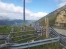
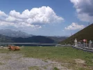
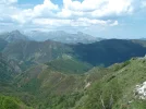
There was a way down at the left, marked with yellow arrows, in the field just at the old parador - through the gate and then the fence/crash barrier. You can just see the arrows on top of the rails in the second photoIt looked frighteningly steep! We were passing through (with car) so did not try walking down it.
 

Attachments

  • pdepajaro.webp
    pdepajaro.webp
    140 KB · Views: 57
  • pdepajaro1.webp
    pdepajaro1.webp
    129.2 KB · Views: 61
  • pdepajaro2.webp
    pdepajaro2.webp
    149.3 KB · Views: 53
Last edited:
3rd Edition. Vital content training & pack guides avoid common mistakes, bed bugs etc
I think that the actual trail from the front of the closed parador is the little path you can see next to the guard rail on the right in Tia's third picture. I walked this way once and have no memory of being freaked out, but the last time I was on the Salvador I took one look and decided to stay on the side of the highway. That's an awful choice, too, but it's not too far to the turn off to get back on the camino.
 
Thanks for that. I remember you mentioned you ended up walking the short stretch of road for about half a mile (?) before rejoining the Camino and that will be my route as well. I know it will be a bit dangerous re oncoming traffic but at least it sounds the most sensible and level option.
 
Just to be clear.
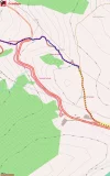
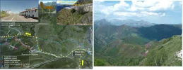
I pasted Tia's picture and put it together with a little map I made in 2013.
I don't think the situation has been changed since 2013.
At the Puerto de Pajares, you have 3 options.
1) Follow the suggested path at point b (yellow dots) till point d
2) Follow the N630 on the right side of the road till d
3) Follow the red dotted path which is (was?) a difficult path
4) From c to h (which seems an option and is also available on the Garmin Topo Map) seems not to be possible just before the railtrack marked with a X - to steep.
ppjares-2013-2017.webp
 
Perfect memento/gift in a presentation box. Engraving available, 25 character max.
Hello Lainey,

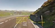
As we bought a drink in the bar at the Puerto de Pajares (I hope it still exists), we decided to walk on the right side on the N630. There is no space on the left side. We only walked at a moment when no traffic was coming from behind. There are 2 or 3 curves where you must pay attention like this one. The advantage is when a truck is coming down, it will come down with a low velocity speed - something like 30 km/h - no cars behind can bypass - so I remember there were safety gaps with a duration of something like 45 seconds. If you check street view in Google, you can "drive" the stretch between c and d. As you can see, it's not so bad. There are some stretches where you can walk in the grass. But please, always look behind you when a car or truck is coming to check if the driver has noticed you.
upload_2017-8-14_14-13-28.webp

The adventure on the N630 ends here at the emergency break track (point d)
upload_2017-8-14_14-33-13.webp
 
Last edited:
€2,-/day will present your project to thousands of visitors each day. All interested in the Camino de Santiago.
I would suggest walking that part from Parador on the left side because there are two lanes (uphill) for oncoming vehicles and they can easily keep the distance from the fence and you. If you walk on the right hand side you will have to look over your shoulder all the time instead of looking where are you stepping. Too dangerous in my opinion!

At least that's what I did last summer in rainfall and everything was cool even with roadworks going on later on the N-630.
 
I agree with @KinkyOne. Walking on the left gives you clear sight of approaching traffic. There are two ascending lanes which provides drivers with 'over-taking' space, and Trucks coming up the hill are going very slowly. (So are the cyclists ;))
 
Thanks to all suggestions. Must admit wben I have had to walk part of any N road in Spain I have always walked on the left. Though it does look a bit of a drop if I have to jump over the barrier to avoid something!
Is the stretch in question about 500m?
 
Before the Camino: Your Pocket Guide to Prepare Your Body and Mind for the Camino
@laineylainey took me & The Beloved more than 5 minutes, less than 10 to walk. We paused once and stood with our packs hanging over the rail while two trucks passed, one in each lane. It was absolutely fine, we just wanted to give the drivers a fair chance. We got a friendly wave and a blast of the horn from the near side driver.

In heavy rain, thick fog or near dark we might have made a different decision. We were on the road on a bright, sunny morning.
 
Please, please do walk on the left and not on the right. As already said the left has 2 lanes and the traffic is travelling uphill and slowly. It also has a more open view and you are facing oncoming traffic.
Having driven this both ways (up and down) I can assure you that you are visible to drivers when walking on your left and facing them. If you walk on the right you are hidden by the bends, and the rock face. The cars and heavy lorries are also moving faster downhill on only one lane and have no room to take evasive action if they only see you at the last minute.
 
Train for your next Camino on California's Santa Catalina Island March 30 to April 2
I walked Salvador a week ago. The standard route is very well signposted now, but the alternatives are not. The notorious point at the 'Water Hut' where you can go horribly wrong is now very well arrowed-up.

Referring to @laineylainey 's map above:

The official marker to turn left when you come through the little gate into Arbas at (a) is rather misleading. It's firmly on the left hand side of the road, and kind of implies you walk on a wide grassy verge, which rapidly breaks up and the path disappears. I had to ask people in the cottages opposite if it was correct to walk on the road. They didn't mention the high blue path option, unfortunately - if anyone could report on the current state of it that would be very valuable.

I think it is preferable to not walk behind the industrial building at (b) but if possible to go along the car park and then to the front of the building and past the bar, especially if walking alone. Mainly because the car park is the kind of place where a weirdo could easily stop their car and loiter with intent in the alley at the back of the big building - I didn't feel very safe there. The difference in distance is barely anything.

I did not enjoy the brief section on the road at all and wouldn't prolong it further than necessary - the descent at (e) is a delightful shady walk and not that steep, I don't see why one would swap it for being grazed by trucks.

The bar is still open at Puerto de Pajares btw.
 
Last edited:
Give back to the Camino. Join us from Logroño to Burgos May 30 to June 8.
Thanks for that @notion900 . Can I check then, you walked the official yellow route on Gunner's map?
Also has anyone rejoined the yellow route easily enough by not going through industrial estate but by going in front of the bar?
Its great to have different options.
@notion900 did you many others on route?
 

❓How to ask a question

How to post a new question on the Camino Forum.

Forum Zoom Chats

Join our Camino Forum Zoom chats every Tuesday. See the next one here.

❓How to ask a question

How to post a new question on the Camino Forum.

Forum Rules

Forum Rules

Camino Updates on YouTube

Camino Conversations

Most downloaded Resources

This site is run by Ivar at

in Santiago de Compostela.
This site participates in the Amazon Affiliate program, designed to provide a means for Ivar to earn fees by linking to Amazon
Official Camino Passport (Credential) | 2024 Camino Guides
Back
Top